
Natural Resources
Conservation Service
Ecological site R109XY032MO
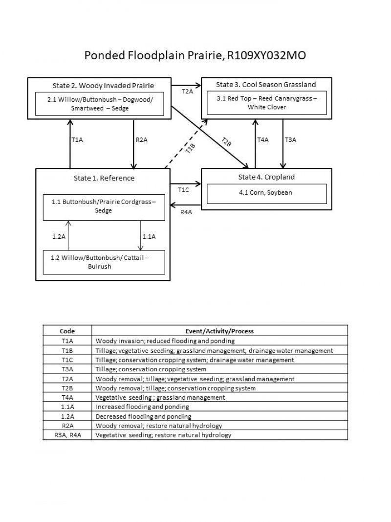
Ponded Floodplain Prairie
Last updated: 7/01/2024
Accessed: 04/10/2026
General information
Provisional. A provisional ecological site description has undergone quality control and quality assurance review. It contains a working state and transition model and enough information to identify the ecological site.
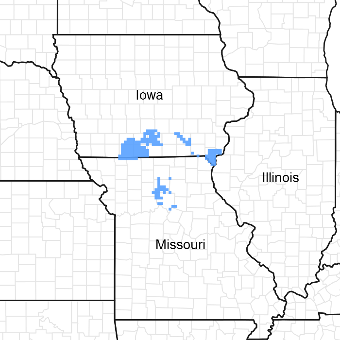
Figure 1. Mapped extent
Areas shown in blue indicate the maximum mapped extent of this ecological site. Other ecological sites likely occur within the highlighted areas. It is also possible for this ecological site to occur outside of highlighted areas if detailed soil survey has not been completed or recently updated.
MLRA notes
Major Land Resource Area (MLRA): 109X–Iowa and Missouri Heavy Till Plain
The Iowa and Missouri Heavy Till Plain is an area of rolling hills interspersed with interfluve divides and alluvial valleys. Elevation ranges from about 660 feet along the lower reaches of rivers, to about 980 feet on stable interfluve summits in southern Iowa. Relief is about 80 to 160 feet between major streams and adjacent interfluve summits. Most of the till plain drains south to the Missouri River via the Grand and Chariton River systems, but the northeastern portion drains southeast to the Mississippi River. Loess caps the pre-Illinoisan aged till on interfluves, whereas the till is exposed on side slopes. Mississippian aged limestone and Pennsylvanian aged sandstone and shale crop out on lower slopes in some areas.
Classification relationships
Terrestrial Natural Community Type in Missouri (Nelson, 2010):
The reference state for this ecological site is most similar to a Wet Bottomland Prairie, or Marsh.
National Vegetation Classification System Vegetation Association (NatureServe, 2010):
The reference state for this ecological site is most similar to Spartina pectinata - Carex spp. - Calamagrostis canadensis - Lythrum alatum - (Oxypolis rigidior) Herbaceous Vegetation (CEGL002224).
Geographic relationship to the Missouri Ecological Classification System (Nigh & Schroeder, 2002):
This ecological site occurs primarily within the Grand River Alluvial Plains Land Type Association of the Grand River Hills Subsection.
Ecological site concept
NOTE: This is a “provisional” Ecological Site Description (ESD) that is under development. It contains basic ecological information that can be used for conservation planning, application and land management. As additional information is collected, analyzed and reviewed, this ESD will be refined and published as “Approved”.
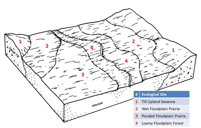
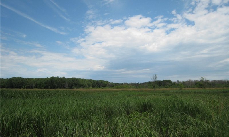
Ponded Floodplain Prairies are not extensive and are primarily in floodplains of the Grand River watershed in the southern part of the MLRA. They occur in depressional areas of the floodplain associated with former meander scars, tributary stream channels and backswamps between natural levees of these once dynamic rivers. They are often associated with Wet Floodplain Prairie ecological sites, which are on slightly higher positions. Soils are very deep, wet, and clayey, and are subject to ponding and flooding. The reference plant community is prairie dominated by a dense cover of wetland species, including buttonbush, willow, prairie cordgrass, sedges, and wet-tolerant forbs.
Associated sites
| F109XY030MO |
Loamy Floodplain Forest Loamy Floodplain Forest sites are often in adjacent, natural levee positions between this site and the active stream channel. |
|---|---|
| F109XY037MO |
Wet Floodplain Woodland Wet Floodplain Woodlands are often in adjacent, slightly higher positions closer to the active stream channel. |
| R109XY031MO |
Wet Floodplain Prairie Wet Floodplain Prairies are often in adjacent, slightly higher backswamp positions. |
| R109XY046MO |
Till Upland Savanna Till Upland Savannas, and other upland prairie and savanna ecological sites, are upslope, on gently sloping backslopes. |
Similar sites
| R109XY031MO |
Wet Floodplain Prairie Wet Floodplain Prairies have many of the same prairie species along with a similar flooding frequency but are higher on the floodplain and not subjected to long ponding periods. |
|---|
Table 1. Dominant plant species
| Tree |
Not specified |
|---|---|
| Shrub |
(1) Cephalanthus occidentalis |
| Herbaceous |
(1) Spartina pectinata |
Click on box and path labels to scroll to the respective text.