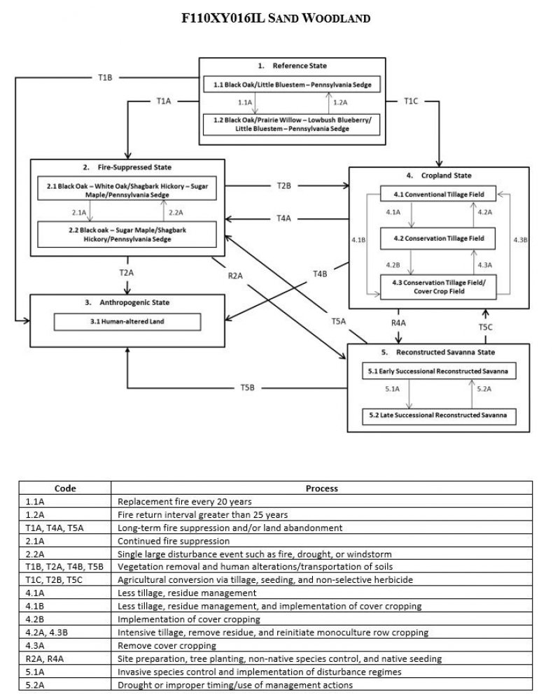
Ecological dynamics
The information in this Ecological Site Description, including the state-and-transition model (STM), was developed based on historical data, current field data, professional experience, and a review of the scientific literature. As a result, all possible scenarios or plant species may not be included. Key indicator plant species, disturbances, and ecological processes are described to inform land management decisions.
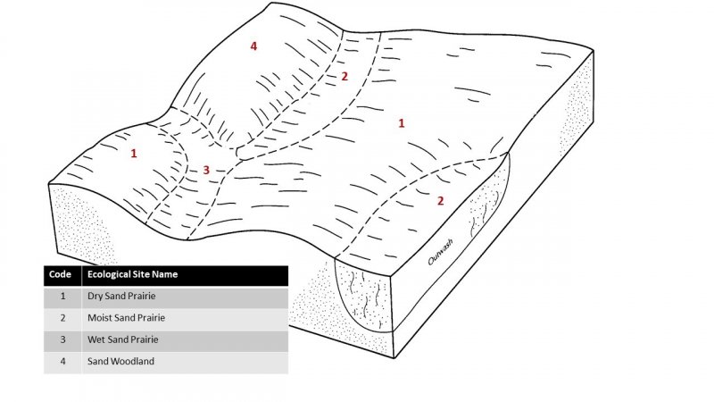
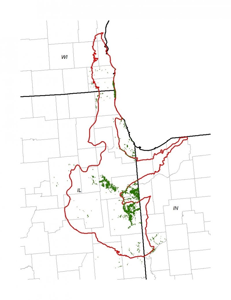
The MLRA lies within the tallgrass prairie ecosystem of the Midwest, but a variety of environmental and edaphic factors resulted in landscape that historically supported prairies, savannas, forests, and various wetlands. Sand Woodlands form an aspect of this vegetative continuum. This ecological site occurs on uplands on somewhat poorly to excessively drained soils. Species characteristic of this ecological site consist of an open canopy of oaks with a continuous understory of herbaceous vegetation.
Fire is a critical factor that maintains Sand Woodlands. Fire typically consisted of low- to moderate-severity surface fires every 15 to 25 years (LANDFIRE 2009). Ignition sources included summertime lightning strikes from convective storms and bimodal, human ignitions during the spring and fall seasons. Native Americans regularly set fires to improve sight lines for hunting, drive large game, improve grazing and browsing habitat, agricultural clearing, and enhance vital ethnobotanical plants (Barrett 1980; LANDFIRE 2009).
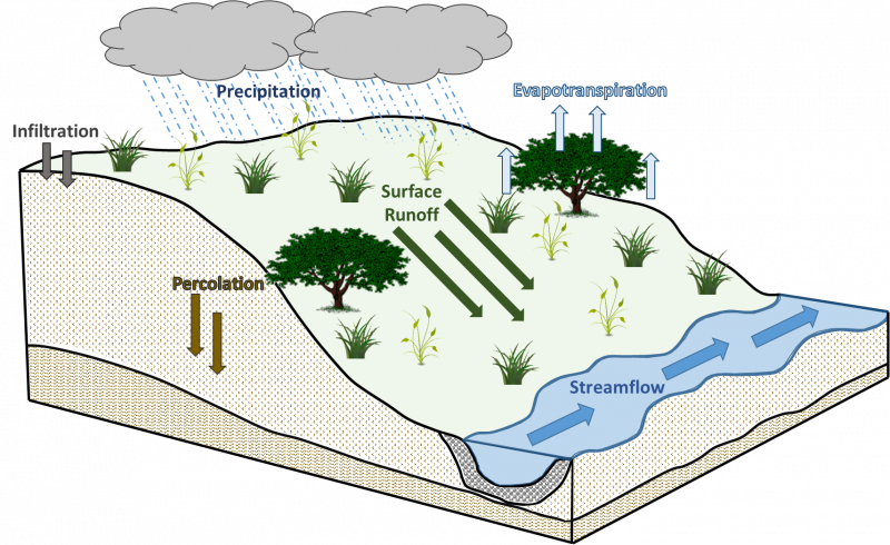
Drought, grazing, and windthrow have also played a role in shaping this ecological site. The periodic episodes of reduced soil moisture in conjunction with the somewhat poorly to excessively-drained soils have favored the proliferation of plant species tolerant of such conditions. Drought can also slow the growth of plants and result in dieback of certain species. Damage to trees from storms can vary from minor, patchy effects of individual trees to stand effects that temporarily affect community structure and species richness and diversity (Irland 2000; Peterson 2000). When coupled with fire, periods of drought, herbivory, and high wind events can greatly delay the establishment and maturation of woody vegetation (Pyne et al. 1996).
Today, Sand Woodlands have been reduced from their pre-settlement extent as a result of type-conversion to agricultural or other human-modified landscape. Remnants that do exist have had fire suppressed long enough to allow the site to convert to a closed canopy forest. A return to the historic plant community may not be possible following extensive land modification, but long-term conservation agriculture or woodland reconstruction efforts can help to restore some biotic diversity and ecological function. The state-and-transition model that follows provides a detailed description of each state, community phase, pathway, and transition. This model is based on available experimental research, field observations, literature reviews, professional consensus, and interpretations.
State 1
Reference State
The reference plant community is categorized as an open oak woodland community, dominated by deciduous trees and herbaceous vegetation. The two community phases within the reference state are dependent on recurring fire intervals. The severity and intensity of fire alters species composition, cover, and extent, while regular fire intervals keep woody species from closing the canopy. Drought, grazing, and windthrow have more localized impacts in the reference phases, but do contribute to overall species composition, diversity, cover, and productivity.
Community 1.1
Black Oak/Little Bluestem - Pennsylvania Sedge
Sites in this reference community phase are an open canopy woodland. Black oak is the dominant tree, on the site. Trees are large (21 to 33 inches DBH) and cover ranges from 61 to 80 percent (LANDFIRE 2009). The open canopy allows for a continuous herbaceous layer. Little bluestem, Pennsylvania sedge, Indiangrass, porcupinegrass are the dominant monocots. Characteristic forbs include flaxleaf whitetop aster, fernleaf yellow false foxglove, and sundial lupine (White and Madany 1978). Surface fires will maintain this phase, but replacement fires every 20 years will shift the community to phase 1.2 (LANDFIRE 2009).
Community 1.2
Black Oak/Prairie Willow - Lowbush Blueberry/Little Bluestem - Pennsylvania Sedge
This reference community phase represents natural succession as a result of reduced fire return interval. Tree size class remains steady, but canopy cover ranges from 21 to 60 percent shifting the site to a savanna. Shrubs develop due to the increasing light availability and can include prairie willow (Salix humilis Marshall), lowbush blueberry (Vaccinium angustifolium Aiton), and New Jersey tea (Ceanothus americanus L.) (White and Madany 1978). Surface fires occurring approximately every 20 years will maintain this phase, but fire intervals beyond 25 years will shift it to community phase 1.1 (LANDFIRE 2009).
Pathway 1.1A
Community 1.1 to 1.2
Replacement fire every 20 years.
Pathway 1.2A
Community 1.2 to 1.1
Fire return interval greater than 25 years.
State 2
Fire-Suppressed State
Long term fire suppression can transition the reference plant community from an open woodland to a closed canopy forest. As the natural fire regime is removed from the landscape, encroachment and dominance by shade-tolerant, fire-intolerant species ensues. This results in a positive feedback loop of mesophication whereby plant community succession continuously creates cool, damp shaded conditions that perpetuate a closed canopy ecosystem (Nowacki and Abrams 2008). Succession to this forested state can occur in as little as 50 years from the last fire (LANDFIRE 2009).
Community 2.1
Black Oak - White Oak/Shagbark Hickory - Sugar Maple/Pennsylvania Sedge
This community phase represents the early stages of long-term fire suppression. The oak canopy increases to 81 to 100 percent cover (LANDFIRE 2009). The subcanopy supports both fire-tolerant and fire-intolerant species including shagbark hickory (Carya ovata (Mill.) K. Koch) and sugar maple (Acer saccharum L.), respectively. The herbaceous layer diversity is reduced and begins to shift to shade-tolerant species. As fire suppression continues, the site will shift to community phase 2.2.
Community 2.2
Black Oak - Sugar Maple/Shagbark Hickory/Pennsylvania Sedge
Sites falling into this community phase have a well-established closed forest canopy. Tree size class is still large, but stem density increases (LANDFIRE 2009). Oaks are still present, but seedlings and saplings are greatly reduced or absent as they are unable to develop in the shade of the forest. Under these closed-canopy stands, the subcanopy and herbaceous layers support only the most shade-tolerant species.
Pathway 2.1A
Community 2.1 to 2.2
Continued fire suppression.
Pathway 2.2A
Community 2.2 to 2.1
Severe disturbance event such as a replacement fire, severe drought, or windstorm.
State 3
Anthropogenic State
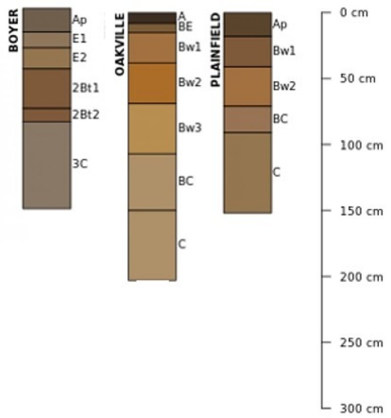
The anthropogenic state occurs when the reference state is cleared and developed for human use and inhabitation, such as for commercial and housing developments, landfills, parks, golf courses, cemeteries, earthen spoils, etc. The native vegetation has been removed and soils have either been altered in place (e.g. cemeteries) or transported from one location to another (e.g. housing developments). Most of the soils in this state have 50 to 100 cm of overburden on top of the natural soil. This natural material can be determined by observing a buried surface horizon or the unaltered subsoil, till, or lacustrine parent materials. This state is generally considered permanent.
Community 3.1
Human-altered land
Sites in this community phase have had the native plant community removed and soils heavily re-worked in support of human development projects.
State 4
Cropland State
The continuous use of tillage, row-crop planting, and chemicals (i.e., herbicides, fertilizers, etc.) has effectively eliminated the reference community and many of its natural ecological functions in favor of crop production. Corn and soybeans are the dominant crops for the site, and common wheat (Triticum aestivum L.) and alfalfa (Medicago sativa L.) may be rotated periodically. These areas are likely to remain in crop production for the foreseeable future.
Community 4.1
Conventional Tillage Field
Sites in this community phase typically consist of monoculture row-cropping maintained by conventional tillage practices. They are cropped in either continuous corn or corn-soybean rotations. The frequent use of deep tillage, low crop diversity, and bare soil conditions during the non-growing season negatively impacts soil health. Under these practices, soil aggregation is reduced or destroyed, soil organic matter is reduced, erosion and runoff are increased, and infiltration is decreased, which can ultimately lead to undesirable changes in the hydrology of the watershed (Tomer et al. 2005).
Community 4.2
Conservation Tillage Field
This community phase is characterized by rotational crop production that utilizes various conservation tillage methods to promote soil health and reduce erosion. Conservation tillage methods include strip-till, ridge-till, vertical-till, or no-till planting systems. Strip-till keeps seedbed preparation to narrow bands less than one-third the width of the row where crop residue and soil consolidation are left undisturbed in-between seedbed areas. Strip-till planting may be completed in the fall and nutrient application either occurs simultaneously or at the time of planting. Ridge-till uses specialized equipment to create ridges in the seedbed and vegetative residue is left on the surface in between the ridges. Weeds are controlled with herbicides and/or cultivation, seedbed ridges are rebuilt during cultivation, and soils are left undisturbed from harvest to planting. Vertical-till systems employ machinery that lightly tills the soil and cuts up crop residue, mixing some of the residue into the top few inches of the soil while leaving a large portion on the surface. No-till management is the most conservative, disturbing soils only at the time of planting and fertilizer application. Compared to conventional tillage systems, conservation tillage methods can improve soil ecosystem function by reducing soil erosion, increasing organic matter and water availability, improving water quality, and reducing soil compaction.
Community 4.3
Conservation Tillage Field/Alternative Crop Field
This community phase applies conservation tillage methods as described above as well as adds cover crop practices. Cover crops typically include nitrogen-fixing species (e.g., legumes), small grains (e.g., rye, wheat, oats), or forage covers (e.g., turnips, radishes, rapeseed). The addition of cover crops not only adds plant diversity but also promotes soil health by reducing soil erosion, limiting nitrogen leaching, suppressing weeds, increasing soil organic matter, and improving the overall soil ecosystem. In the case of small grain cover crops, surface cover and water infiltration are increased, while forage covers can be used to graze livestock or support local wildlife. Of the three community phases for this state, this phase promotes the greatest soil sustainability and improves ecological functioning within a cropland system.
Pathway 4.1A
Community 4.1 to 4.2
Tillage operations are greatly reduced, crop rotation occurs on a regular interval, and crop residue remains on the soil surface.
Pathway 4.1B
Community 4.1 to 4.3
Tillage operations are greatly reduced or eliminated, crop rotation occurs on a regular interval, crop residue remains on the soil surface, and cover crops are planted following crop harvest.
Pathway 4.2A
Community 4.2 to 4.1
Intensive tillage is utilized, and monoculture row-cropping is established.
Pathway 4.2B
Community 4.2 to 4.3
Cover crops are implemented to minimize soil erosion.
Pathway 4.3B
Community 4.3 to 4.1
Intensive tillage is utilized, cover crop practices are abandoned, monoculture row-cropping is established, and crop rotation is reduced or eliminated.
Pathway 4.3A
Community 4.3 to 4.2
Cover crop practices are abandoned.
State 5
Reconstructed Sand Woodland State
The combination of natural and anthropogenic disturbances occurring today has resulted in numerous forest health issues, and restoration back to the historic reference condition may not be possible. Woodlands are being stressed by non-native diseases and pests, habitat fragmentation, changes in soil conditions, and overabundant deer populations on top of naturally occurring disturbances (severe weather and native pests) (IFDC 2018). However, these habitats provide multiple ecosystem services including carbon sequestration; clean air and water; soil conservation; biodiversity support; wildlife habitat; timber, fiber, and fuel products; as well as a variety of cultural activities (e.g., hiking, camping, hunting) (Millennium Ecosystem Assessment 2005; IFDC 2018). Therefore, conservation of forests and woodlands should still be pursued. Woodland reconstructions are an important tool for repairing natural ecological functioning and providing habitat protection for numerous species associated with Sand Woodlands. Therefore, ecological restoration should aim to aid the recovery of degraded, damaged, or destroyed ecosystems. A successful restoration will have the ability to structurally and functionally sustain itself, demonstrate resilience to the ranges of stress and disturbance, and create and maintain positive biotic and abiotic interactions (SER 2002). The reconstructed sand woodland state is the result of a long-term commitment involving a multi-step, adaptive management process.
Community 5.1
Early Successional Reconstructed Woodland
This community phase represents the early community assembly from woodland reconstruction. It is highly dependent on the current condition of the site based on past and current land management actions, invasive species, and proximity to land populated with non-native pests and diseases. Therefore, no two sites will have the same early successional composition. Technical forestry assistance should be sought to develop suitable conservation management plans.
Community 5.2
Late Successional Reconstructed Woodland
Appropriately timed management practices (e.g., prescribed fire, hazardous fuels management, forest stand improvement, continuing integrated pest management) applied to the early successional community phase can help increase the stand maturity, pushing the site into a late successional community phase over time. A late successional reconstructed woodland will have an uneven-aged canopy and a well-developed shrub layer and understory.
Pathway 5.1A
Community 5.1 to 5.2
Application of stand improvement practices in line with a developed management plan.
Pathway 5.2A
Community 5.2 to 5.1
Reconstruction experiences a setback from extreme weather event or improper timing of management actions.
Transition T1A
State 1 to 2
Long-term suppression transitions the site to the fire-suppressed state (2).
Transition T1B
State 1 to 3
Vegetation removal and human alterations/transportation of soils transitions the site to the anthropogenic state (3).
Transition T1C
State 1 to 4
Tillage, seeding of agricultural crops, and non-selective herbicide transition the site to the cropland state (4).
Transition T2A
State 2 to 3
Vegetation removal and human alterations/transportation of soils transitions the site to the anthropogenic state (3).
Transition T2B
State 2 to 4
Tillage, seeding of agriculture crops, and non-selective herbicide transition this site to the cropland state (4).
Restoration pathway R2A
State 2 to 5
Site preparation, tree planting, invasive species control, and seeding native species transition this site to the reconstructed sand woodland state (5).
Transition T4A
State 4 to 2
Land abandonment transitions the site to the fire-suppressed state (2).
Transition T4B
State 4 to 3
Vegetation removal and human alterations/transportation of soils transitions the site to the anthropogenic state (3).
Restoration pathway R4A
State 4 to 5
Site preparation, tree planting, invasive species control, and seeding native species transition this site to the reconstructed sand woodland state (5).
Transition T5A
State 5 to 2
Fire suppression and removal of active management transitions this site to the fire-suppressed state (2).
Transition T5B
State 5 to 3
Vegetation removal and human alterations/transportation of soils transitions the site to the anthropogenic state (3).
Transition T5C
State 5 to 4
Tillage, seeding of agricultural crops, and non-selective herbicide transition this site to the cropland state (4).

