Natural Resources
Conservation Service
Ecological site R111XC011IN
Limnic Muck
Accessed: 12/22/2024
General information
Provisional. A provisional ecological site description has undergone quality control and quality assurance review. It contains a working state and transition model and enough information to identify the ecological site.
MLRA notes
Major Land Resource Area (MLRA): 111X–Indiana and Ohio Till Plain
A PROVISIONAL ECOLOGICAL SITE is a conceptual grouping of soil map unit components within a Major Land Resource Area (MLRA) based on the similarities in response to management. Although there may be wide variability in the productivity of the soils grouped into a Provisional Site, the soil vegetation interactions as expressed in the State and Transition Model are similar and the management actions required to achieve objectives, whether maintaining the existing ecological state or managing for an alternative state, are similar. Provisional Sites are likely to be refined into more precise group during the process of meeting the APPROVED ECOLOGICAL SITE DESCRIPTION criteria.
This PROVISIONAL ECOLOGICAL SITE has been developed to meet the standards established in the National Ecological Site Handbook. The information associated with this ecological site does not meet the Approved Ecological Site Description Standard, but it has been through a Quality Control and Quality Assurance processes to assure consistency and completeness. Further investigations, reviews and correlations are necessary before it becomes an Approved Ecological Site Description.
111C – Indiana and Ohio Till Plain, Northwestern Part. This MLRA is in the glaciated part of north-central Indiana and is dominated by glacial till plains broken in places by lake plains, outwash plains, and flood plains. Areas that parallel most of the major rivers and streams have deposits of sand.
Although it is an important agricultural region, MLRA 111C hosts a large proportion of Indiana’s biodiversity.
Classification relationships
Major Land Resource Area (MLRA)(USDA-Natural Resources Conservation Service, 2006)
USFS Ecological Regions (USDA, 2007):
Sections - Central Till Plains, Beech Maple (222H), South Central Great Lakes (222J), Central Till Plains and Grand Prairies (251D)
Subsections - Kalamazoo-Elkhart Moraines and Plains (222Jh), Steuben Interlobate Moraines (222Ji), Bluffton Till Plains (222Ha), Entrenched Valleys (222Hf), Miami-Scioto Plain-Tipton Till Plain (222Hb), Kankakee Sands (251Dg) and Eastern Grand Prairie (251Dd).
NatureServe Systems anticipated (NatureServe, 2011): Agriculture-Pasture/Hay, Agriculture-Cultivated Crops and Irrigated Agriculture, Central Tallgrass Prairie, Laurentian-Acadian Wet Meadow-Shrub Swamp, North-Central Interior and Appalachian Acidic Peatland, North-Central Interior Freshwater Marsh, North-Central Interior Wet Meadow-Shrub Swamp.
LANDFIRE Biophysical Settings anticipated (USGS, 2010): Central Interior and Appalachian Swamp Systems, Central Interior and Appalachian Shrub-Herbaceous wetland systems, North Central Wet Flatwoods, Central Tallgrass Prairie, Great Lakes Wet-Mesic Lakeplain Prairie, Laurentian-Acadian Shrub-Herbaceous Wetland Systems.
Ecological site concept
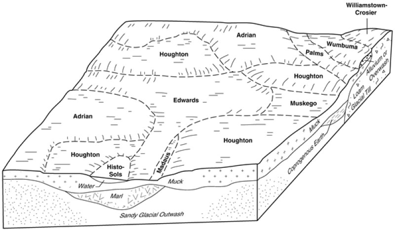
This site is an upland site formed on herbaceous organic soil parent material in depressions on lake and till plains. There are 4 distinct states: 1. mucky prairie, 2. fire suppressed state, 3. agriculture state and 4. invaded state. This is a fire dependent community in which regular fires allowed for the dominance of herbaceous species. Currently about 90% of the site is in agricultural production.
Associated sites
| R111XC012IN |
Mineral Muck Similar landform positions, but do not have marly materials in the soil profile. Prairie cordgrass is a co-dominate. |
|---|---|
| R111XC013IN |
Deep Muck Occur adjacent to and in the same landscape positions. Organic material is 51 inches thick or greater. Bullrushes, cattails, and other more water dependent species are dominant. |
Similar sites
| R111XC002IN |
Wet Sandy Interdune Vegetation type and some species are in both sites as well as similar landscape position. Soils types differ greatly; this one is sandy parent material. |
|---|---|
| R111XC005IN |
Glacial Depression Vegetation type and some species are in both sites as well as similar landscape position. Soils types differ greatly; this one is till parent material. |
Table 1. Dominant plant species
| Tree |
Not specified |
|---|---|
| Shrub |
Not specified |
| Herbaceous |
(1) Andropogon gerardii |
Click on box and path labels to scroll to the respective text.
