Natural Resources
Conservation Service
Ecological site R111XD007IN
Till Depression Prairie
Last updated: 9/11/2024
Accessed: 02/07/2026
General information
Provisional. A provisional ecological site description has undergone quality control and quality assurance review. It contains a working state and transition model and enough information to identify the ecological site.
MLRA notes
Major Land Resource Area (MLRA): 111X–Indiana and Ohio Till Plain
A PROVISIONAL ECOLOGICAL SITE is a conceptual grouping of soil map unit components within a Major Land Resource Area (MLRA) based on the similarities in response to management. Although there may be wide variability in the productivity of the soils grouped into a Provisional Site, the soil vegetation interactions as expressed in the State and Transition Model are similar and the management actions required to achieve objectives, whether maintaining the existing ecological state or managing for an alternative state, are similar. Provisional Sites are likely to be refined into more precise group during the process of meeting the APPROVED ECOLOGICAL SITE DESCRIPTION criteria.
This PROVISIONAL ECOLOGICAL SITE has been developed to meet the standards established in the National Ecological Site Handbook. The information associated with this ecological site does not meet the Approved Ecological Site Description Standard, but it has been through a Quality Control and Quality Assurance processes to assure consistency and completeness. Further investigations, reviews and correlations are necessary before it becomes an Approved Ecological Site Description.
111D – Indiana and Ohio Till Plain, Western Part. This MLRA occurs in two separate areas. One area is in the west-central part of Indiana (73 percent), and the other is in southwestern Ohio (27 percent). The MLRA makes up 5,355 square miles (13,880 square kilometers). It includes the towns of Crawfordville, Delphi, Frankfort, Lafayette, and Liberty, Indiana, and Hamilton, Lebanon, Middletown, and Wilmington, Ohio. Interstates 65 and 74 cross the part of this area in Indiana, and Interstates 71 and 75 cross the part in Ohio. Shades and Turkey Run State Parks are in the part in Indiana, and Caesar Creek and Hueston Woods State Parks are in the part in Ohio. A small portion of the Wright-Patterson Air Force Base, in Ohio, is in the northern part of the area.
This area is in the Till Plains Section of the Central Lowland Province of the Interior Plains. It is dominated by loess hills and flats that are broken in places by moraines, kames, outwash plains, and stream terraces. Narrow, shallow valleys commonly are along the few large streams in the area. Elevation ranges from 530 to 1,050 feet (160 to 320 meters), increasing gradually from southwest to northeast. Relief is mainly a few meters, but in some areas hills rise as much as 100 feet (30 meters) above the adjoining plains.
The extent of the major Hydrologic Unit Areas (identified by four-digit numbers) that make up this MLRA is as follows: Wabash (0512), 68 percent; Great Miami (0508), 15 percent; Middle Ohio (0509), 14 percent; Scioto (0506,) 2 percent; and Upper Illinois (0712), 1 percent. Wildcat Creek in Indiana and the Little Miami River in Ohio have been designated as National Wild and Scenic Rivers. Sugar Creek and Walnut Creek occur in the part of the area in northern Indiana, and the Whitewater River is in the part in southeastern Indiana. The Sevenmile, Fourmile, and Great Miami Rivers cross the part of the area in Ohio.
Most of the eastern part of this MLRA is underlain by Late Ordovician shale and limestone. The western part is underlain by shale, siltstone, sandstone, limestone, and dolostone ranging in age from Middle Pennsylvanian to Silurian. Surficial materials include glacial deposits of till, outwash, and lacustrine sediments from Wisconsin and older glacial periods. A thin or moderately thick mantle of loess overlies much of the area.
Classification relationships
Major Land Resource Area (USDA-Natural Resources Conservation Service, 2006)
USFS Ecological Regions (USDA, 2007):
Sections –Central Till Plains, Beech Maple (222H), Interior Low Plateau-Shawnee Hills (223D), Interior Low Plateau-Bluegrass (223F), Central Till Plains-Oak Hickory (223G), Central Till Plains and Grand Prairies (251D)
Subsections -Bluffton Till Plains (222Ha), Miami-Scioto Plain-Tipton Till Plain (222Hb), Little Miami Old Drift Plain (222Hc), Mad River Interlobate Plains (222Hd), Crawford Uplands (223De), Crawford Escarpment (223Df), Northern Bluegrass (223Fd), Lower Wabash Alluvial Plain (223Gc), Southwest Indiana Glaciated Lowlands (223Ge), Eastern Grand Prairie (253Dd).
NatureServe Systems anticipated (NatureServe, 2011): Agriculture - Cultivated Crops and Irrigated Agriculture, Agriculture - Pasture/Hay, Allegheny-Cumberland Dry Oak Forest and Woodland, Central Interior Acidic Cliff and Talus, Central Interior Highlands Calcareous Glade and Barrens, Central Tallgrass Prairie, Clearcut - Grassland/Herbaceous, Introduced Upland Vegetation – Treed, Managed Tree Plantation, Mississippi River Riparian Forest, North-Central Interior and Appalachian Acidic Peatland, North-Central Interior Beech-Maple Forest, North-Central Interior Dry-Mesic Oak Forest and Woodland, North-Central Interior Dry Oak Forest and Woodland, North-Central Interior Floodplain, North-Central Interior Freshwater Marsh, North-Central Interior Maple-Basswood Forest, North-Central Interior Oak Savanna, North-Central Interior Wet Flatwoods, North-Central Interior Wet Meadow-Shrub Swamp, North-Central Oak Barrens, Northern Atlantic Coastal Plain Hardwood Forest ,Ruderal Forest, Ruderal Upland - Old Field, South-Central Interior / Upper Coastal Plain Wet Flatwoods, South-Central Interior Large Floodplain, South-Central Interior Mesophytic Forest, South-Central Interior Small Stream and Riparian, Southern Appalachian Oak Forest, Southern Interior Low Plateau Dry-Mesic Oak Forest, Successional Shrub/Scrub
LANDFIRE Biophysical Settings anticipated (USGS, 2010): Allegheny-Cumberland Dry Oak Forest and Woodland, Bluegrass Savanna and Woodland, Central Interior and Appalachian Floodplain Systems, Central Interior and Appalachian Riparian Systems, Central Interior and Appalachian Shrub-Herbaceous Wetland Systems, Central Interior and Appalachian Swamp Systems, Central Interior Highlands Calcareous Glade and Barrens, Central Interior Highlands Dry Acidic Glade and Barrens, Central Tallgrass Prairie, Great Lakes Coastal Marsh Systems, Mississippi River Alluvial Plain Dry-Mesic Loess Slope Forest, North-Central Interior Beech-Maple Forest, North-Central Interior Dry-Mesic Oak Forest and Woodland, North-Central Interior Dry Oak Forest and Woodland, North-Central Interior Maple-Basswood Forest, North-Central Interior Oak Savanna, North-Central Interior Wet Flatwoods, Paleozoic Plateau Bluff and Talus, Pennyroyal Karst Plain Prairie and Barrens, South-Central Interior Mesophytic Forest, South-Central Interior/Upper Coastal Plain Flatwoods, Southern Appalachian Oak Forest, Southern Interior Low Plateau Dry-Mesic Oak Forest
Ecological site concept
This site is an upland site formed on glacial till parent materials. It is located on the depressions, toeslopes and footslopes, of glacial till plains and moraines. Soil surface is dark in color (3/2 Munsell) and extends beyond 10 inches. The soils are well drained and taxonomically mollisols.
The characteristic vegetation of this site is that of a till prairie dominated by tall-grass prairie species, specifically big bluestem and Indiangrass. Switchgrass and prairie dropseed are other grass species that are common on the site. A diverse assemblage of forbs occur on this site to include, but not limited to, milkweed, asters, sunflowers, and coneflower species. This is a fire dependent system with fires occurring nearly annually or at least every 4 years. The short fire return interval kept woody species from invading and becoming dominant. Larger scale, higher intensity fires occurred during the dormant season with more frequent, smaller fires during the growing season. Grazing by native animals probably had some impact on species richness and diversity, but not near to the extent as exhibited on prairies further west. Due to the productiveness of the mollisols in which this site is found on, the majority of this site has been converted for agricultural production. Areas that have not been converted to agricultural use are now mostly in a woodland state as the fire cycle has been altered and in most cases completely eliminated.
Associated sites
| R111XD006IN |
Mollic Till Depression Located on an adjacent landscape position; dark soil surface color extends less than 10 inches deep. |
|---|---|
| R111XD011IN |
Mollic Till Ridge Located on a swell (convex) landscape position; dark soil surface color is less than 10 inches deep. |
Similar sites
| R111XD021IN |
Dry Outwash Mollisol Located on outwash parent material; soils are moderately well to excessively drained. |
|---|---|
| R111XD012IN |
Till Ridge Prairie Located on a swell (convex) landscape position. |
| R111XD020IN |
Wet Outwash Mollisol Located on outwash parent material; soils are very poorly to somewhat poorly drained. |
| R111XD026IN |
Sand Dune Prairie Located on sand parent material on a dune landscape. |
Table 1. Dominant plant species
| Tree |
Not specified |
|---|---|
| Shrub |
Not specified |
| Herbaceous |
(1) Andropogon gerardii |
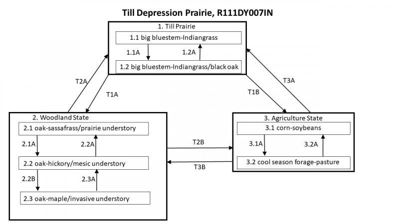
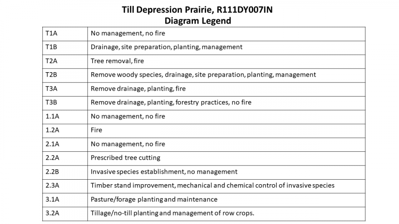
Click on box and path labels to scroll to the respective text.

