Natural Resources
Conservation Service
Ecological site F113XY919IL
Wet Silty Floodplain Forest
Last updated: 5/17/2024
Accessed: 04/12/2025
General information
Provisional. A provisional ecological site description has undergone quality control and quality assurance review. It contains a working state and transition model and enough information to identify the ecological site.
MLRA notes
Major Land Resource Area (MLRA): 113X–Central Claypan Areas
The eastern Illinois portion of the Central Claypan Areas MLRA is in the Till Plains Section of the Central Lowland Province of the Interior Plains (USDA-NRCS, 2006) and includes the Southern Till Plain Natural Division of the natural divisions of Illinois (Schwegman, 1973; 1997; IDNR, 2018) in south-central Illinois. South-central Illinois is a dissected Illinoisan till plain south of the terminal Wisconsin moraine. This region consists of nearly level to gently sloping, old till plains. Stream valleys are shallow and generally are narrow. Elevation is about 660 feet (200 meters), increasing gradually from south to north. Local relief is generally low on the broad, flat till plains and flood plains and high on the dissected hills bordering rivers or drainage systems. The Kaskaskia, Little Muddy, Little Wabash, Embarras, and Skillet Fork rivers are part of this area. This region is covered with loess, which overlies old glacial drift (Illinoisan till) that has a high content of clay. Fragipans are also present. Pennsylvanian limestone and shale bedrock underlay the glacial till. The dominant soil orders in this region are Alfisol and Mollisol. The soils in the area predominantly have a mesic soil temperature regime, an aquic or udic soil moisture regime, and mixed or smectitic mineralogy. They generally are very deep, well drained to poorly drained, and loamy or clayey. (USDA-NRCS, 2006).
Classification relationships
Major Land Resource Area (MLRA) (USDA-NRCS, 2006):
113 – Central Claypan Areas, Eastern Part
U.S. Forest Service Ecoregions (Cleland et al. 2007):
Domain: Humid Temperate Domain
Division: Hot Continental Division
Province: Eastern Broadleaf Forest (Continental)
Province Code: 222
Section: Central Till Plains, Oak-Hickory Section
Section Code: 222G
Ecological site concept
The historic pre-European settlement vegetation on this site was dominated by a continuous canopy of deciduous trees with an understory of shade-tolerant shrubs and ground flora (LANDFIRE 2009). They occur in floodplains along the channel. Soils are poorly drained and very deep formed from silty alluvium that are seasonally inundated or saturated for one or two months during the growing season resulting in a plant community with hydrophytic woody and herbaceous vegetation (Nelson 2010; White 1978).
Wet Silty Floodplain Forests resemble Loamy Floodplain Forests, except they lack species of oak (Quercus spp.) and black walnut (Juglans nigra L.)* that do not tolerate extended periods of wetness that can occur in these units. In addition, the ground flora may be barren because of frequent flooding and occasional ponding. Common hackberry (Celtis occidentalis L.) is one of the dominant and diagnostic trees in this ecological site, while green ash (Fraxinus pennsylvanica Marshall) and American elm (Ulmus americana L.) are also important canopy components along with occasional pecans (Carya illinoinensis (Wangenh.) K. Koch). The shrub layer is generally sparse but may contain roughleaf dogwood (Cornus drummondii, C.A. Mey.) and hawthorn (Crataegus spp.) species. Herbaceous species typical of an undisturbed plant community associated with this ecological site include bedstraws (Galium spp.), violets (Viola spp), sedges (Carex spp.), smallspike false nettle (Boehmeria cylindrica (L.) Sw.), Canadian woodnettle (Laportea canadensis (L.) Weddell), and touch-me-not (Impatiens spp.). Vines most often encountered include eastern poison ivy (Toxicodendron radicans (L.) Kuntze), trumpet creeper (Campsis radicans (L.) Seem. ex Bureau), and Virginia creeper (Parthenocissus quinquefolia (L.) Planch.). (Nelson 2010; Ladd and Thomas 2015). Historically, seasonal flooding was the primary disturbance factor, while windthrow events and beaver alterations were secondary factors (LANDFIRE 2009; Nelson 2010; NatureServe 2018; Voigt and Mohlenbrock 1964).
* All plant common and scientific names in this document were obtained from the U.S. Department of Agriculture – Natural Resources Conservation Service National PLANTS Database (USDA NRCS, 2018).
Associated sites
| F113XY924IL |
Clayey Floodplain Forest This ecological site is located along backwater stream river courses and experiences less disturbance from flooding being farther from the river course.. |
|---|---|
| F113XY920IL |
Silty Floodplain Forest This ecological site is located in the floodplain on better drained sites. |
Similar sites
| F113XY924IL |
Clayey Floodplain Forest This ecological site is located along backwater stream river courses and experiences less disturbance from flooding being farther from the river course. |
|---|
Table 1. Dominant plant species
| Tree |
(1) Celtis occidentalis |
|---|---|
| Shrub |
(1) Cornus drummondii |
| Herbaceous |
(1) Laportea canadensis |
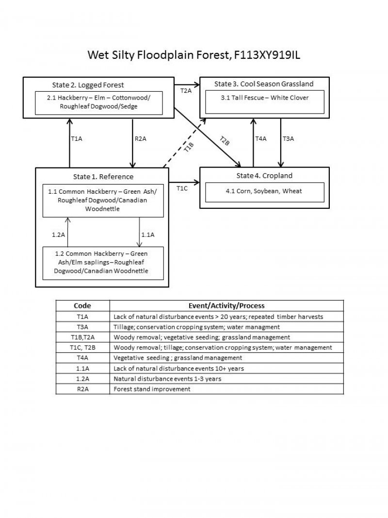
Click on box and path labels to scroll to the respective text.
| T1A | - | Lack of disturbance >20 years; repeated timber harvests. |
|---|---|---|
| T1B | - | Woody removal; vegetative seeding; grassland management |
| T1C | - | Woody removal; Tillage; conservation cropping system; water management |
| R2A | - | Forest stand improvement |
| T2A | - | Woody removal; vegetative seeding; grassland management |
| T2B | - | Woody removal; tillage; conservation cropping system; water management. |
| T3A | - | Tillage; conservation cropping system; water management |
| T4A | - | Vegetative seeding ; grassland management |
State 1 submodel, plant communities
| 1.1A | - | Lack of natural disturbance events > 10 years |
|---|---|---|
| 1.2A | - | Natural disturbance 1-3 years |
