Natural Resources
Conservation Service
Ecological site F113XY922IL
Loamy Floodplain Forest
Last updated: 5/17/2024
Accessed: 11/21/2024
General information
Provisional. A provisional ecological site description has undergone quality control and quality assurance review. It contains a working state and transition model and enough information to identify the ecological site.
MLRA notes
Major Land Resource Area (MLRA): 113X–Central Claypan Areas
The eastern Illinois portion of the Central Claypan Areas MLRA is in the Till Plains Section of the Central Lowland Province of the Interior Plains (USDA-NRCS, 2006) and includes the Southern Till Plain Natural Division of the natural divisions of Illinois (Schwegman, 1973; 1997; IDNR, 2018) in south-central Illinois. South-central Illinois is a dissected Illinoisan till plain south of the terminal Wisconsin moraine. This region consists of nearly level to gently sloping, old till plains. Stream valleys are shallow and generally are narrow. Elevation is about 660 feet (200 meters), increasing gradually from south to north. Local relief is generally low on the broad, flat till plains and flood plains and high on the dissected hills bordering rivers or drainage systems. The Kaskaskia, Little Muddy, Little Wabash, Embarras, and Skillet Fork rivers are part of this area. This region is covered with loess, which overlies old glacial drift (Illinoisan till) that has a high content of clay. Fragipans are also present. Pennsylvanian limestone and shale bedrock underlay the glacial till. The dominant soil orders in this region are Alfisol and Mollisol. The soils in the area predominantly have a mesic soil temperature regime, an aquic or udic soil moisture regime, and mixed or smectitic mineralogy. They generally are very deep, well drained to poorly drained, and loamy or clayey. (USDA-NRCS, 2006).
Classification relationships
Major Land Resource Area (MLRA) (USDA-NRCS, 2006):
113 – Central Claypan Areas, Eastern Part
U.S. Forest Service Ecoregions (Cleland et al. 2007):
Domain: Humid Temperate Domain
Division: Hot Continental Division
Province: Eastern Broadleaf Forest (Continental)
Province Code: 222
Section: Central Till Plains, Oak-Hickory Section
Section Code: 222G
Ecological site concept
The historic pre-European settlement vegetation on this site was dominated by a continuous canopy of deciduous trees with an understory of shade-tolerant shrubs and ground flora (LANDFIRE 2009). Loamy Floodplain Forests occur in floodplain steps on smaller floodplains. Soils are well drained and very deep formed from coarse, silty alluvium that are occasional to frequently flooded (Nelson 2010; White 1978).
This sycamore – black walnut mesic floodplain forest occurs on well drained floodplain steps and small streams. Stands are dominated by American sycamore (Platanus occidentalis L.)*, with a mixture of other species, including boxelder (Acer negundo L.), silver maple (Acer saccharinum L.), white ash (Fraxinus americana L.), green ash (Fraxinus pennsylvanica Marshall), black walnut (Juglans nigra L.), American elm (Ulmus americana L.), bitternut hickory (Carya cordiformis (Wangenh.), white oak (Quercus alba L.), basswood (Tilia americana L.) and slippery elm (Ulmus rubra Muhl.). Shrubs include pawpaw (Asimina triloba (L.) Dunal) and northern spicebush (Lindera benzoin (L.) Blume). Vines may be abundant, including Virginia creeper (Parthenocissus quinquefolia (L.) Planch.) and eastern poison ivy (Toxicodendron radicans (L.) Kuntze). Herbaceous species include Jack in the pulpit (Arisaema triphyllum (L.) Schott), Canadian wildginger (Asarum canadense L.), smallspike false nettle (Boehmeria cylindrica (L.) Sw.), Virginia wildrye (Elymus virginicus L.), Canadian clearweed (Pilea pumila (L.) A. Gray), and jumpseed (Polygonum virginianum L.). Historically, seasonal, short duration flooding was the primary disturbance factor, while windthrow events and beaver alterations were secondary factors (LANDFIRE 2009; Nelson 2010; NatureServe 2018; Voigt and Mohlenbrock 1964; White 1978).
Associated sites
| F113XY911IL |
Loamy Till Backslope Forest This ecological site is located on steep backslopes above Loamy Floodplain Forests. |
|---|---|
| F113XY919IL |
Wet Silty Floodplain Forest This ecological site is located in lower floodplains with Loamy Floodplain Forests. |
| F113XY920IL |
Silty Floodplain Forest This ecological site is located in floodplains generally adjacent to but lower than Loamy Floodplain Forests. |
Similar sites
| F113XY920IL |
Silty Floodplain Forest This ecological site is located in lower floodplain areas from Loamy Floodplain Forests. |
|---|
Table 1. Dominant plant species
| Tree |
(1) Platanus occidentalis |
|---|---|
| Shrub |
(1) Asimina triloba |
| Herbaceous |
(1) Elymus virginicus |
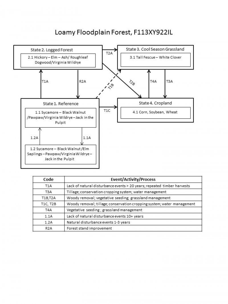
Click on box and path labels to scroll to the respective text.
| T1A | - | Lack of natural disturbance events >20 years; repeated timber harvests. |
|---|---|---|
| T1B | - | Woody removal; vegetative seeding; grassland management |
| T1C | - | Woody removal; tillage; conservation cropping system; water management |
| R2A | - | Forest stand improvement |
| T2A | - | Woody removal; vegetative seeding; grassland management |
| T2B | - | Woody removal; tillage; conservation cropping system; water management |
| T3A | - | Tillage; conservation cropping system; water management |
| T4A | - | Vegetative seeding; grassland management |
State 1 submodel, plant communities
| 1.1.A | - | No disturbance events for over 10 years |
|---|---|---|
| 1.2.A | - | Natural disturbance 1-3 years |
