Natural Resources
Conservation Service
Ecological site R113XY903IL
Wet Upland Prairie
Last updated: 5/17/2024
Accessed: 12/05/2025
General information
Provisional. A provisional ecological site description has undergone quality control and quality assurance review. It contains a working state and transition model and enough information to identify the ecological site.
MLRA notes
Major Land Resource Area (MLRA): 113X–Central Claypan Areas
The eastern Illinois portion of the Central Claypan Areas MLRA is in the Till Plains Section of the Central Lowland Province of the Interior Plains (USDA-NRCS, 2006) and includes the Southern Till Plain Natural Division of the natural divisions of Illinois (Schwegman, 1973; 1997; IDNR, 2018) in south-central Illinois. South-central Illinois is a dissected Illinoisan till plain south of the terminal Wisconsin moraine. This region consists of nearly level to gently sloping, old till plains. Stream valleys are shallow and generally are narrow. Elevation is about 660 feet (200 meters), increasing gradually from south to north. Local relief is generally low on the broad, flat till plains and flood plains and high on the dissected hills bordering rivers or drainage systems. The Kaskaskia, Little Muddy, Little Wabash, Embarras, and Skillet Fork rivers are part of this area. This region is covered with loess, which overlies old glacial drift (Illinoisan till) that has a high content of clay. Fragipans are also present. Pennsylvanian limestone and shale bedrock underlay the glacial till. The dominant soil orders in this region are Alfisol and Mollisol. The soils in the area predominantly have a mesic soil temperature regime, an aquic or udic soil moisture regime, and mixed or smectitic mineralogy. They generally are very deep, well drained to poorly drained, and loamy or clayey. (USDA-NRCS, 2006). Northern crayfish frog (Lithobates areolatus), ornate box turtle (Terrapene ornata ornate) and remnant populations of greater prairie-chickens (Tympanuchus cupido) are characteristic animals of this region (IDNR, 2018).
Classification relationships
Major Land Resource Area (MLRA) (USDA-NRCS, 2006):
113 – Central Claypan Areas, Eastern Part
U.S. Forest Service Ecoregions (Cleland et al. 2007):
Domain: Humid Temperate Domain
Division: Hot Continental Division
Province: Eastern Broadleaf Forest (Continental)
Province Code: 222
Section: Central Till Plains, Oak-Hickory Section
Section Code: 222G
Ecological site concept
This wet-mesic prairie community type is found in south-central Illinois throughout the Central Claypan Areas MLRA. Wet Upland Prairies occur on broad, flat summits of hillslopes and knolls with slopes of 0 to 2 percent in soils that formed in loess and clayey glacial till that seasonally perches water. The soils are somewhat poorly to poorly drained and deep. Standing surface water may be present for varying periods in the winter and spring or after heavy rains. A water table is near or at the surface.
The historic reference plant community was a wet-mesic grassland with a tree canopy of less than 10 percent. There is a single layer of dominant graminoids intermixed with abundant forbs and occasional scattered shrubs (NatureServe 2018). Big bluestem (Andropogon gerardii Vitman*) and prairie cordgrass (Spartina pectinata Bosc ex Link) are common in this wet-mesic community. Switchgrass (Panicum virgatum L.) is typically present as well. Other characteristic plants found in this community are fourflower yellow loosestrife (Lysimachia quadriflora Sims), meadow evening primrose (Oenothera pilosella Raf.), golden zizia (Zizia aurea (L.) W.D.J. Koch), inland rush (Juncus interior Wiegand), eastern gamagrass (Tripsacum dactyloides (L.) L), sawtooth sunflower (Helianthus grosseserratus M. Martens), common cinquefoil (Potentilla simplex Michx.), rattlesnake master (Eryngium yuccifolium Michx.), Bicknell's sedge (Carex bicknellii Britton) and bluejoint (Calamagrostis canadensis (Michx.) P. Beauv.) (White 1978; NatureServe 2018). Shrubs, such as silky dogwood (Cornus obliqua Raf.) and narrow-leaved meadowsweet (Spiraea alba), were present but not overly abundant (Mohlenbrock and Ladd, 1978; Mohlenbrock, 1986). Species diversity does not tend to be as high as in more mesic grassland communities. Fire was common in this community. (NatureServe 2018).
* All plant common and scientific names in this document were obtained from the U.S. Department of Agriculture – Natural Resources Conservation Service National PLANTS Database (USDA NRCS, 2018).
Associated sites
| R113XY902IL |
Natric Till Plain Savanna Similar landscape position and drainage but soil profile has high sodium levels that impact species composition. |
|---|---|
| F113XY905IL |
Wet Upland Woodland Similar drainage and landscape position but woody species have a greater species dominance due to Fragic soil characteristics. |
| R113XY904IL |
Upland Prairie Prairie ecological site is often on better drained soils associated with loess over till plains. |
Similar sites
| R113XY904IL |
Upland Prairie Prairie ecological site is often on better drained soils associated with loess over till plains. |
|---|
Table 1. Dominant plant species
| Tree |
Not specified |
|---|---|
| Shrub |
(1) Cornus obliqua |
| Herbaceous |
(1) Andropogon gerardii |
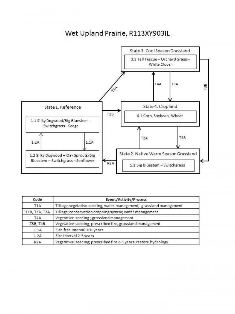
Click on box and path labels to scroll to the respective text.
| T1A | - | Tillage; vegetative seeding; grassland management |
|---|---|---|
| T1B | - | Tillage; conservation cropping system; water management |
| R2A | - | Vegetative seeding; prescribed fire 2-5 years; restore hydrology |
| T2A | - | Tillage; conservation cropping system; water management |
| T3B | - | Vegetative seeding; prescribed fire; grassland management |
| T3A | - | Tillage; conservation cropping system; water management |
| T4B | - | Vegetative seeding; prescribed fire; grassland management |
| T4A | - | Vegetative seeding ; grassland management |
State 1 submodel, plant communities
| 1.1A | - | Fire-free interval 10+ years |
|---|---|---|
| 1.2A | - | Fire interval 2-5 years |
