Natural Resources
Conservation Service
Ecological site R113XY914IL
Wet Lacustrine Terrace Prairie
Last updated: 5/17/2024
Accessed: 02/26/2026
General information
Provisional. A provisional ecological site description has undergone quality control and quality assurance review. It contains a working state and transition model and enough information to identify the ecological site.
MLRA notes
Major Land Resource Area (MLRA): 113X–Central Claypan Areas
The eastern Illinois portion of the Central Claypan Areas MLRA is in the Till Plains Section of the Central Lowland Province of the Interior Plains (USDA-NRCS, 2006) and includes the Southern Till Plain Natural Division of the natural divisions of Illinois (Schwegman, 1973; 1997; IDNR, 2018) in south-central Illinois. South-central Illinois is a dissected Illinoisan till plain south of the terminal Wisconsin moraine. This region consists of nearly level to gently sloping, old till plains. Stream valleys are shallow and generally are narrow. Elevation is about 660 feet (200 meters), increasing gradually from south to north. Local relief is generally low on the broad, flat till plains and flood plains and high on the dissected hills bordering rivers or drainage systems. The Kaskaskia, Little Muddy, Little Wabash, Embarras, and Skillet Fork rivers are part of this area. This region is covered with loess, which overlies old glacial drift (Illinoisan till) that has a high content of clay. Fragipans are also present. Pennsylvanian limestone and shale bedrock underlay the glacial till. The dominant soil orders in this region are Alfisol and Mollisol. The soils in the area predominantly have a mesic soil temperature regime, an aquic or udic soil moisture regime, and mixed or smectitic mineralogy. They generally are very deep, well drained to poorly drained, and loamy or clayey. (USDA-NRCS, 2006).
Classification relationships
Major Land Resource Area (MLRA) (USDA-NRCS, 2006):
113 – Central Claypan Areas, Eastern Part
U.S. Forest Service Ecoregions (Cleland et al. 2007):
Domain: Humid Temperate Domain
Division: Hot Continental Division
Province: Eastern Broadleaf Forest (Continental)
Province Code: 222
Section: Central Till Plains, Oak-Hickory Section
Section Code: 222G
Ecological site concept
This wet prairie community type is found in southeast-central Illinois of the Central Claypan Areas MLRA. Wet Lacustrine Terrace Prairies occur on lacustrine terraces and lake plains with slopes of 0 to 2 percent in soils that seasonally perch water. The soils are poorly drained and very deep. Standing surface water may be present for varying periods in the winter and spring or after heavy rains. A water table is near or at the surface.
The historic reference plant community was a wet grassland with a tree and shrub canopy of less than 10 percent. A dense layer of graminoids dominates this community. Forbs and shrubs are also common. The vegetation is typically 1 to 2 meters tall. Bluejoint (Calamagrostis canadensis (Michx.) P. Beauv.* ) and (Spartina pectinata Bosc ex Link) are the two most abundant species. Several common sedge species (Carex spp.) found in this community include hairy sedge (Carex lacustris Willd.), ravenfoot sedge (Carex crus-corvi Shuttlw. ex Kunze), awlfruit sedge (Carex stipata Muhl. ex Willd.), and woolly sedge (Carex pellita Muhl. ex Willd.). Other species associated with this community include (Andropogon gerardii Vitman), New England aster (Symphyotrichum novae-angliae (L.) G.L. Nesom), sawtooth sunflower (Helianthus grosseserratus M. Martens), harlequin blueflag (Iris versicolor L.), prairie blazing star (Liatris pycnostachya Michx.), winged lythrum (Lythrum alatum Pursh), switchgrass (Panicum virgatum L.), Virginia mountainmint (Pycnanthemum virginianum (L.) T. Dur. & B.D. Jacks. ex B.L. Rob. & Fernald), giant goldenrod (Solidago gigantea Aiton), purple meadow-rue (Thalictrum dasycarpum Fisch. & Avé-Lall.), and Culver's root (Veronicastrum virginicum (L.) Farw.). In some instances composition may show more of a meadow character, with swamp milkweed (Asclepias incarnata L.), rice cutgrass (Leersia oryzoides (L.) Sw.), hemlock waterparsnip (Sium suave Walter), and marsh hedgenettle (Stachys palustris L.) listed as characteristic plants. (Mohlenbrock and Ladd, 1978; Mohlenbrock, 2003; NatureServe 2018; Nelson 2010; White and Madany 1978) Periodic prolonged ponding and fire were natural disturbances that prevented woody vegetation from dominating this community (NatureServe 2018).
* All plant common and scientific names in this document were obtained from the U.S. Department of Agriculture – Natural Resources Conservation Service National PLANTS Database (USDA NRCS, 2018).
Associated sites
| F113XY905IL |
Wet Upland Woodland Wet Upland Woodlands typically occur adjacent to Wet Lacustrine Terrace Prairies and have similar slopes and drainages but are wooded. |
|---|---|
| F113XY920IL |
Silty Floodplain Forest Wet Silty Floodplain Forests occupy the areas adjacent to but lower on the landscape and are wooded. |
Similar sites
| R113XY903IL |
Wet Upland Prairie Wet Upland Prairies have similar drainage and species composition but occur higher on the landscape. |
|---|
Table 1. Dominant plant species
| Tree |
Not specified |
|---|---|
| Shrub |
(1) Cephalanthus occidentalis |
| Herbaceous |
(1) Spartina pectinata |
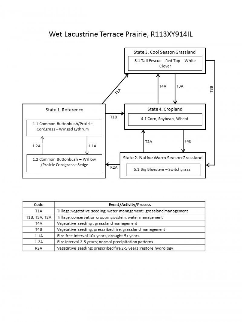
Click on box and path labels to scroll to the respective text.
| T1A | - | Tillage; vegetative seeding; water management; grassland management |
|---|---|---|
| T1B | - | Tillage; conservation cropping system; water management |
| R2A | - | Vegetative seeding; prescribed fire 2-5 years; restore hydrology |
| T2A | - | Tillage; conservation cropping system; water management |
| T3B | - | Vegetative seeding, prescribed fire,, grassland management |
| T3A | - | Tillage; conservation cropping system; water management. |
| T4B | - | Vegetative seeding; prescribed fire; grassland management |
| T4A | - | Vegetative seeding ; grassland management |
State 1 submodel, plant communities
| 1.1A | - | Fire-free interval 10+ years; drought 5 plus years |
|---|---|---|
| 1.2A | - | Fire interval 2-5 years; normal precipitation patterns |
