Natural Resources
Conservation Service
Ecological site F114XA204IN
Alluvium Forest
Last updated: 9/26/2024
Accessed: 02/07/2026
General information
Provisional. A provisional ecological site description has undergone quality control and quality assurance review. It contains a working state and transition model and enough information to identify the ecological site.
MLRA notes
Major Land Resource Area (MLRA): 114X–Southern Illinois and Indiana Thin Loess and Till Plain
MLRA 114 makes up about 4,550 square miles (11,795 square kilometers. The three parts of this MRLA are mostly in the Till Plains Section of the Central Lowland Province of the Interior Plains. The western third of the western part is in the Highland Rim Section of the Interior Low Plateaus Province of the Interior Plains. The eastern half of the eastern part is in the Kanawha Section of the Appalachian Plateaus Province of the Appalachian Highlands. Both large and small tributaries of the Ohio River dissect the nearly level to very steep glaciated uplands in this area. The major streams and rivers have well defined valleys with broad flood plains and numerous stream terraces. The flood plains along the smaller streams are narrow. Broad summits are nearly level to gently sloping. Elevation ranges from 320 feet (100 meters) on the southernmost flood plain along the Ohio River to 1,250 feet (380 meters) on the highest ridges. Local relief is mainly 10 to 50 feet (3 to 15 meters), but it can be 50 to 100 feet (15 to 30 meters) along drainageways and streams. Also, the Ohio River bluffs are as much as 300 feet (90 meters) above the river valley floor.
Classification relationships
USFS: 222 Eastern Broadleaf Forest (Continental) Province
Homoya's Natural Regions of Indiana: Bluegrass Region
The following NatureServe Explorer Ecological System has a high level of probability to match the ecological site found on these soils. Field verification is needed prior to using this information for conservation planning and/or restoration initiatives:
Ecological site concept
Alluvium Forest sites were historically a mature deciduous floodplain forest with a closed canopy consisting of multiple co-dominant species. Canopy trees included American elm (Ulmus americana), sugar maple (Acer saccharum), northern red oak (Quercus rubra), bitternut hickory (Carya cordiformis), mockernut hickory (Carya tomentosa), black walnut (Juglans nigra), and white ash (Fraxinus americana) Black walnut would be found on the better drained sites. Forest shrub and understory composition will vary depending on the flooding regime, disturbances, and microtopography. Today, many floodplain sites that are still wooded have had the oaks removed and due to disease, the American elm is no longer dominant.
Active hydrologic and geomorphic process, along with windthrow of established trees, are the causal factors in long interval disturbance regimes on these sites. These macro and micro scale disturbance events may create mixed-aged forests that contains both late and early seral species. Today, these natural dynamics have been drastically changed due to the installation of levees, dams, channeling, ditching and tiling.
Associated sites
| F114XA203IN |
Wet Alluvium Forest Wet Alluvium sites are associated with these sites. |
|---|
Similar sites
| F114XA102IN |
Lacustrine Terrace Forest Lacustrine Terrace Forest sites share many similar species. |
|---|
Table 1. Dominant plant species
| Tree |
(1) Ulmus americana |
|---|---|
| Shrub |
(1) Asimina triloba |
| Herbaceous |
(1) Parthenocissus quinquefolia |
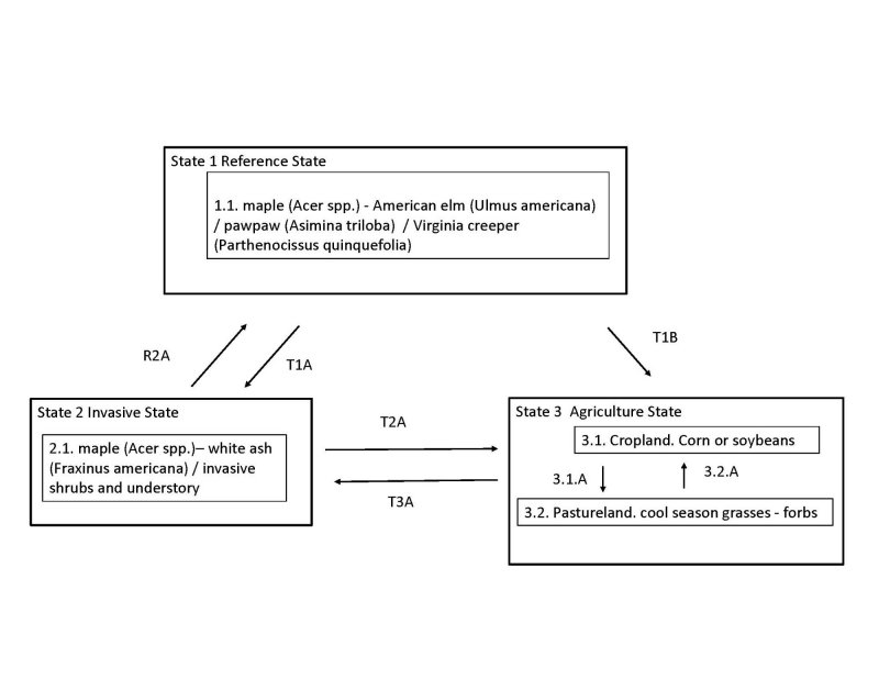
Click on box and path labels to scroll to the respective text.
| T1A | - | Large scale disturbance; invasion of non-native species |
|---|---|---|
| T1B | - | Clearing; site preparation; seeding; agriculture management |
| R2A | - | Brush and weed control; planting of desired species; timber stand improvement inputs |
| T2A | - | Clearing; site preparation; seeding; agricultural management |
| T3A | - | Abandonment; no management inputs |
State 1 submodel, plant communities
State 2 submodel, plant communities
State 3 submodel, plant communities
| 3.1A | - | Seeding; weed control; grassland management |
|---|---|---|
| 3.2A | - | Site preparation; tillage; seeding; weed control; cropland management |


