Natural Resources
Conservation Service
Ecological site F116AY090MO
Low-Base Chert Upland Pine Woodland
Last updated: 5/28/2025
Accessed: 04/10/2026
General information
Provisional. A provisional ecological site description has undergone quality control and quality assurance review. It contains a working state and transition model and enough information to identify the ecological site.
MLRA notes
Major Land Resource Area (MLRA): 116A–Ozark Highland
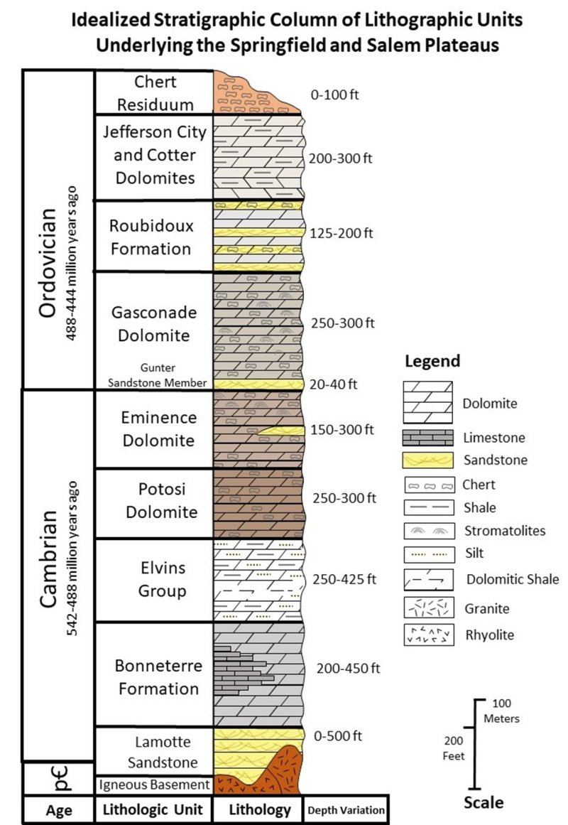
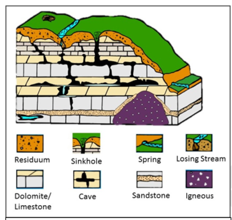
The Ozark Highland MLRA constitutes the Salem Plateau of the Ozark Uplift. Elevation ranges from about 300 feet on the southeast edge of the Ozark escarpment, to about 1,600 feet in the west, adjacent to the Burlington Escarpment of the Springfield Plateau. The underlying bedrock is mainly horizontally bedded Ordovician-aged dolomites and sandstones that dip gently away from the uplift apex in southeast Missouri. Cambrian dolomites are exposed on deeply dissected hillslopes. In some places, Pennsylvanian and Mississippian sediments overlie the plateau. Relief varies, from the gently rolling central plateau areas to deeply dissected hillslopes associated with drainageways such as the Buffalo, Current, Eleven Point and White Rivers (USDA, 2014).
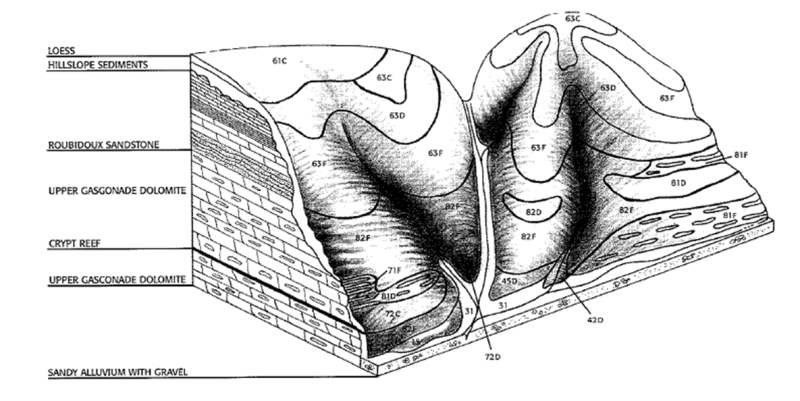
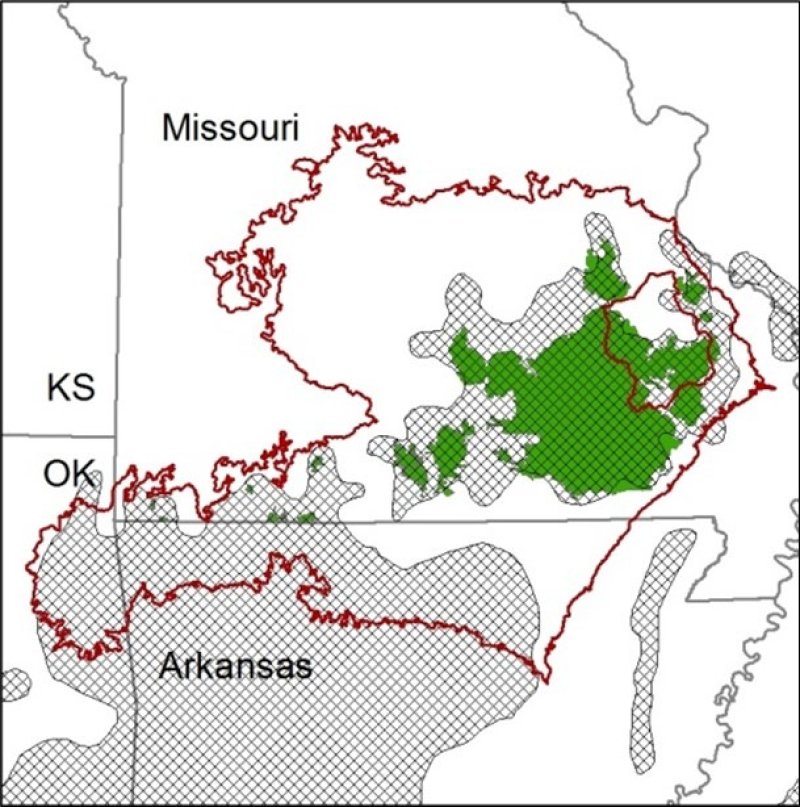
The Current River Hills subsection (OZ9) (Figure 5) of the Ozark Highland lies on the southeastern flank of the broad Ozark uplift. Strata dip gently southward, but they appear in any locality as horizontal. The subsection is underlain by a variety of formations. High, gently rolling dissected plains and hills are underlain mainly by resistant sandstones and dolomites of the Roubidoux Formation. More deeply dissected lands are cut first into the dolomites of the Ordovician Gasconade Formation, and then, in the deepest valleys, into the Cambrian Eminence-Potosi Formation. Some of the higher ridges are underlain by the Ordovician Jefferson City–Cotter dolomite, which although present, often occurs as a remnant landform with completely weathered bedrock beneath. All materials in the thick sequence of carbonate rocks are soluble and create karst topography, including some very large springs and caverns, sinkholes, box (blunt headed) valleys, and dry valleys. Although not karst, areas of sandstone often produce extensive areas of sinkholes into the weathered dolomite beneath the surface. Surficial materials are clayey or loamy with numerous rock fragments, chiefly insoluble chert left behind as the carbonate rocks are dissolved. The land surface is thoroughly dissected with narrow ridges and valleys and steep slopes near the major rivers and broader ridges and valleys more distant from the rivers. Except on the highest, loess-covered divides, the landscape, including river bottoms, is conspicuously mantled with rock fragments. Local relief throughout most of the subsection is 200 to 600 feet (Nigh and Schroeder, 2002).
LRU notes
Land-type association (LTA) in the Current River Hills subsection:
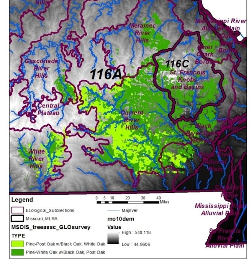
Current River Pine-Oak Woodland Dissected Plain: The LTA consists of a moderately dissected upland plain associated with the Roubidoux Formation. Relief over large tracts averages less than 100 feet but increase towards the river margins. Karst occurs in several areas (Figure 6). The LTA was historically and is currently covered in pine and pine-oak woodland and forest associated with sandy soils. It also includes many unique sinkhole pond communities (Nigh and Schroeder, 2002).
Classification relationships
• Major Land Resource Area (MLRA):116A – Ozark Highland (Current River Hills subsection)
• USDA Forest Service (FS) National Hierarchical Framework of Ecological Units: 200 Humid Temperate Domain; 222 Eastern Broadleaf Forest (Continental) Division/Province; 222A Ozark Highlands Section/Subsection
Terrestrial Natural Community Type in Missouri: The reference state for this ecological site is most like a Dry Chert Woodland; Community Variation and Subtype: shortleaf pine, post oak/lowbush blueberry (Nelson, 2010).
Missouri Department of Conservation Forest and Woodland Communities: The reference state for this ecological site is most like a Pine Oak Woodland in the historic pine range (MDC, 2006).
National Vegetation Classification System Vegetation Association: The reference state for this ecological site is most like Shortleaf Pine–Post Oak–Blackjack Oak–Little Bluestem Woodland (Pinus echinata - Quercus stellata - Quercus marilandica / Schizachyrium scoparium Woodland) (CEGL002393) (NatureServe, 2010).
LANDFIRE Biophysical Setting Reference Conditions: Ozark Ouachita Shortleaf Pine Bluestem Woodland. BsP 441507 (LANDFIRE, 2008).
Atlas of Missouri Ecoregions: This ecological site is widespread across the Ozark Highlands Section, Current River Hills subsection, OZ9a Current River Pine-Oak Woodland Dissected Plain Landtype Association (Nigh and Schroeder, 2002).
Forest Service Desired Conditions for Natural Community Types by Management Prescription: Shortleaf Pine/Oak/Bluestem (Open); Dry and Dry-mesic Chert Woodland (Forest Service, 2005).
Ecological site concept
Low-base Chert Upland Pine Woodland ecological sites are widely distributed on dissected hillslopes in the south and west regions of the Ozark Highland. These sites range from broad summits associated with the minimally dissected divides between the rivers, to narrow ridges in highly dissected rugged hills nearer the rivers. They are often associated with hillslope sediments derived from the Roubidoux and upper Gasconade geologic formations.
This ecological site typically occurs above Low Base Backslope Woodlands that frequently have Dolomite Glade/Woodland units nested within them. Within the historic pine range, shortleaf pine was a common overstory component. Soils are typically very deep, acidic, and low in bases such as calcium, with an abundance of chert fragments.
The historic vegetation contained an open canopy dominated by shortleaf pine. Common canopy associates included black hickory (Carya texana), post oak (Quercus stellata), white oak (Quercus alba), black oak (Quercus velutina), blackjack oak (Quercus marilandica), and persimmon (Diospyros virginiana). Grassy openings were dominated by little bluestem (Schizachyrium scoparium). Abundant herbs included longbract wild indigo (Baptisia bracteata), hairy sunflower (Helianthus hirsutus), tall blazing star (Liatris aspera), gray goldenrod (Solidago nemoralis), downy ragged goldenrod (Solidago petiolaris), and Virginia tephrosia (Tephrosia virginiana). (NatureServe, 2010).
Forest Service National Hierarchical Framework of Ecological Units for this area (Bailey, 1995) indicate that dry upland sites include post oak, blackjack oak, and black hickory with lichen-moss ground cover, and shortleaf pine-oak in areas of sandstone bedrock. Mesic slopes sites have white oak (Quercus alba), northern red oak (Quercus rubra), and bitternut hickory (Carya cordiformis) - flowering dogwood (Cornus florida). Glades have little bluestem and bald grass (Sporobolus vaginiflorus var. ozarkanus). Eastern redcedar (Juniperus virginiana) has invaded many of these sites because of fire suppression (Bailey, 1995).
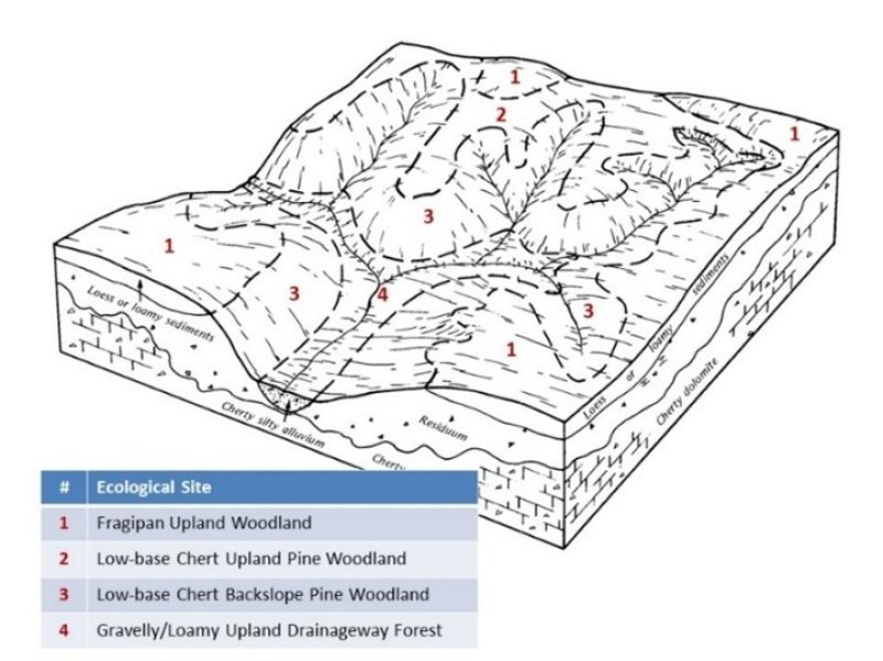
Associated sites
| F116AY004MO |
Fragipan Upland Woodland Fragipan Upland Woodlands are upslope, on summits. |
|---|---|
| F116AY037MO |
Gravelly/Loamy Upland Drainageway Forest Gravelly/Loamy Upland Drainageway Forests are often downslope. |
Similar sites
| F116AY049MO |
Low-Base Chert Exposed Backslope Woodland The Low-base Chert Exposed Backslope Woodlands occupy the southerly and westerly aspects of steep, dissected slopes. Soils are typically very deep, acidic, and low in bases such as calcium, with an abundance of chert fragments. Soil acidity is an important factor affecting the distribution of both tree and ground flora species and their growth. As a soil profile approaches or arrives at lower levels of pH, exchangeable aluminum comes into solution and can directly impact plant growth and composition. The reference plant community is a woodland of black oak and white oak, with shortleaf pine in the historic shortleaf pine range, and a ground flora of native grasses and forbs. |
|---|---|
| F116AY012MO |
Low-Base Chert Upland Woodland Low-base Chert Upland Woodlands are widely distributed on dissected hillslopes. Within the historic pine range this ecological site was usually dominated by shortleaf pine. Soils are typically very deep, acidic, and low in bases such as calcium, with an abundance of chert fragments. The reference plant community is a woodland of white oak and black oak, with shortleaf pine in the historic pine range, and a ground flora of native grasses and forbs. |
| F116AY011MO |
Chert Upland Woodland Chert Upland Woodlands are widely distributed on dissected hillslopes throughout the Ozark Highland. Soils are typically very deep, with an abundance of chert fragments. The reference plant community is woodland with an overstory dominated by white oak and black oak, and a ground flora of native grasses and forbs. |
| F116AY062MO |
Chert Exposed Backslope Woodland The Chert Exposed Backslope Woodlands occupy the southerly and westerly aspects of steep, dissected slopes, and are mapped in complex with the Chert Protected Backslope Forest ecological site. Chert Backslope ecological sites are common throughout the Ozark Highland where major streams have dissected deeply into the Salem Plateau. Soils are typically very deep, with an abundance of chert fragments. The reference plant community is a woodland with an overstory dominated by black oak and white oak and a ground flora of native grasses and forbs. |
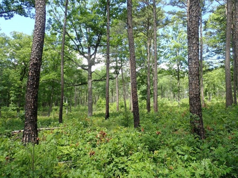
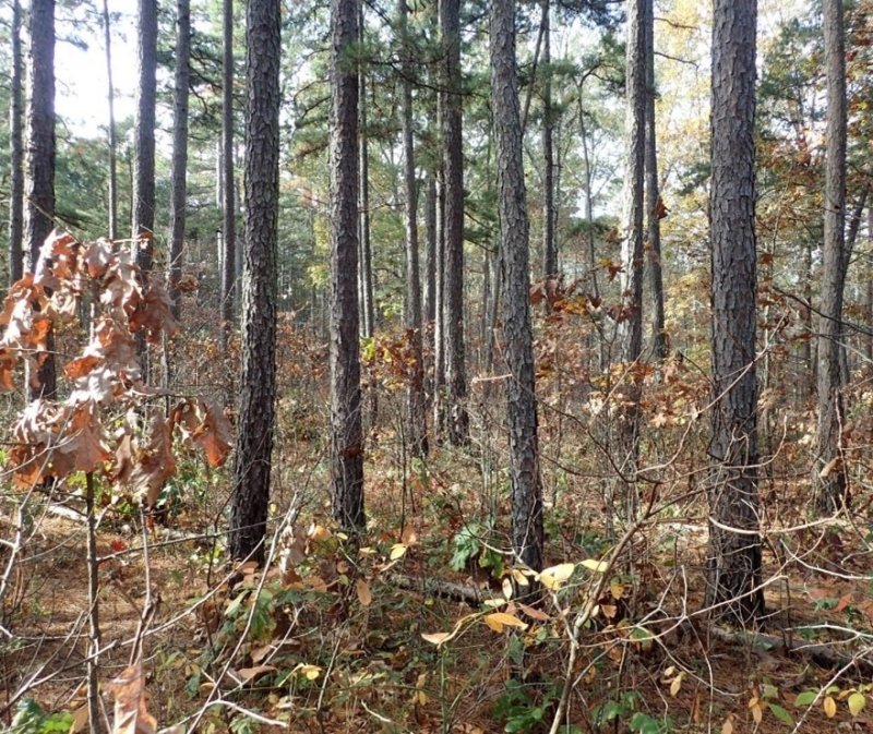
Figure 1. Pistol Barrell burn unit, Ozark National Scenic Riverways, Jacks Fork River, Shannon County (from FS).
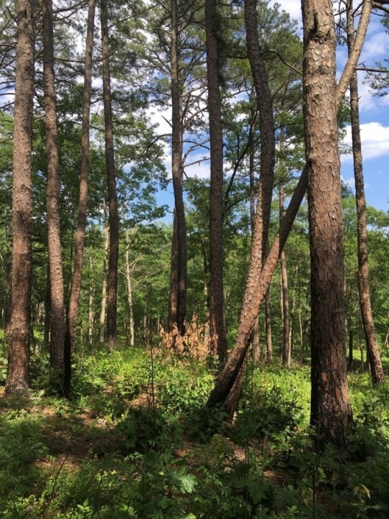
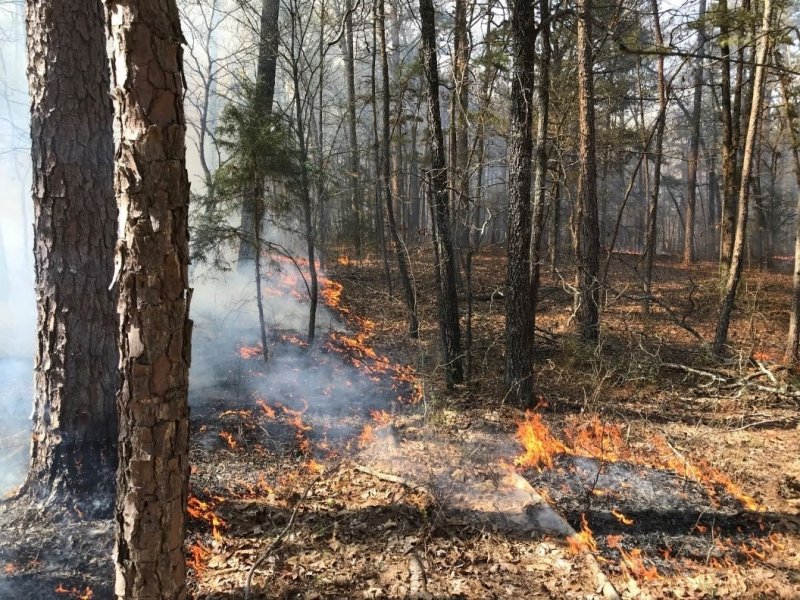
Figure 2. Pineknot Restoration Area, Ozark National Scenic Riverways, Carter County (from FS).
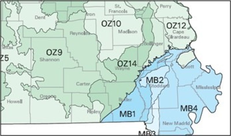
Figure 3. Location of the Current River Hills subsection associated with MLRA 116A. (Figure from Nigh and Schroeder, 2002)
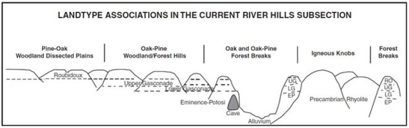
Figure 4. (Nigh and Schroeder, 2002)
Table 1. Dominant plant species
| Tree |
(1) Pinus echinata |
|---|---|
| Shrub |
(1) Vaccinium pallidum |
| Herbaceous |
(1) Schizachyrium scoparium |
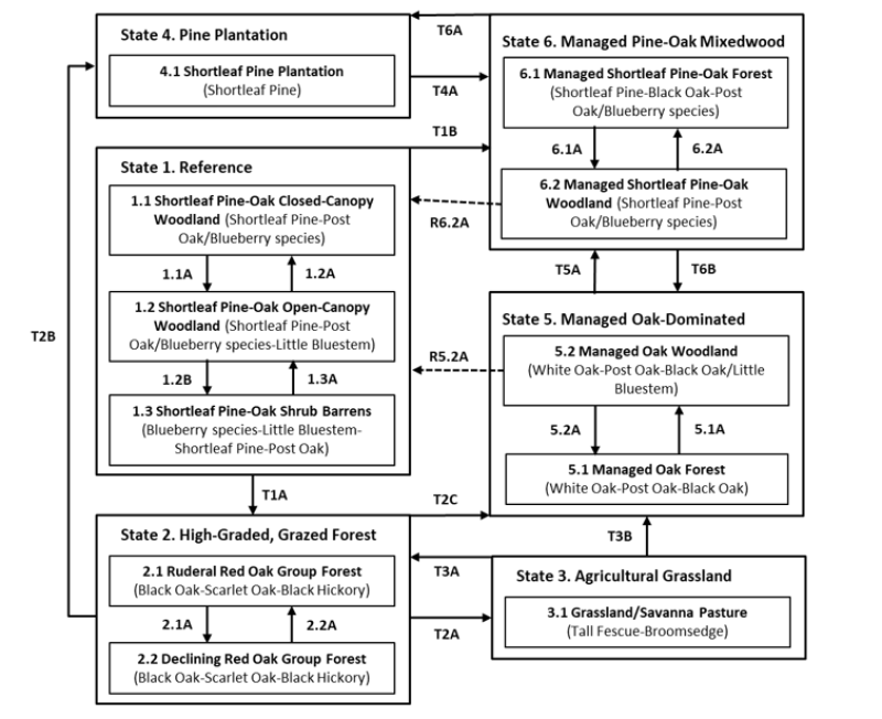
Click on box and path labels to scroll to the respective text.
Ecosystem states
States 1, 5 and 6 (additional transitions)
States 2 and 5 (additional transitions)
| T1A | - | High grading/clearcutting; uncontrolled grazing; fire suppression |
|---|---|---|
| T1B | - | Silvicultural management, including possible planting of shortleaf pine and hardwood competition control |
| T2A | - | Land clearing; pasture planting; grazing |
| T2B | - | Clearcutting; seeding or planting of shortleaf pine and associated hardwood competition control |
| T2C | - | Long-term succession (50+ years) and silvicultural management to favor establishment of white and post oaks |
| T3A | - | Grazing excluded; long-term succession (50+ years) |
| T3B | - | Planting of desireable oaks; silvicultural management including thinning; long-term succession (50+ years) |
| T4A | - | Silvicultural management to establish a new cohort, including possible planting of shortleaf pine and hardwood competition control |
| R5A | - | Long-term silvicultural management, including shortleaf pine planting and hardwood competition control, to create a mosaic of age cohorts under a regime of frequent prescribed fire |
| T5A | - | Planting of shortleaf pine and associated hardwood competition control |
| R6A | - | Long-term silvicultural management to create a mosaic of age cohorts under a regime of frequent prescribed fire |
| T6A | - | Clearcutting; planting of shortleaf pine and associated hardwood competition control |
| T6B | - | Clearcutting |
State 1 submodel, plant communities
| 1.1A | - | Increased fire frequency |
|---|---|---|
| 1.2A | - | Reduced fire frequency |
| 1.2B | - | Canopy-opening disturbance (e.g., high-severity fire or blowdown event) |
| 1.3A | - | Periodic recruitment of shortleaf pine and oaks, perhaps during a slightly longer interval between fires |
State 2 submodel, plant communities
| 2.1A | - | Succession in the absence of management |
|---|---|---|
| 2.2A | - | High grading/clearcutting; uncontrolled grazing; fire suppression |
State 3 submodel, plant communities
State 4 submodel, plant communities
State 5 submodel, plant communities
| 5.1A | - | Thinning; frequent prescribed fire |
|---|---|---|
| 5.2A | - | Cessation of prescribed fire |
State 6 submodel, plant communities
| 6.1A | - | Thinning; frequent prescribed fire |
|---|---|---|
| 6.2A | - | Cessation of prescribed fire |