
Natural Resources
Conservation Service
Ecological site R116AY020MO
Shallow Dolomite Upland Glade/Woodland
Last updated: 12/18/2024
Accessed: 02/08/2026
General information
Approved. An approved ecological site description has undergone quality control and quality assurance review. It contains a working state and transition model, enough information to identify the ecological site, and full documentation for all ecosystem states contained in the state and transition model.
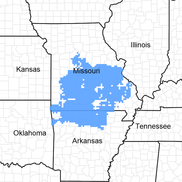
Figure 1. Mapped extent
Areas shown in blue indicate the maximum mapped extent of this ecological site. Other ecological sites likely occur within the highlighted areas. It is also possible for this ecological site to occur outside of highlighted areas if detailed soil survey has not been completed or recently updated.
MLRA notes
Major Land Resource Area (MLRA): 116A–Ozark Highland
The Ozark Highland constitutes the Salem Plateau of the Ozark Uplift. Elevation ranges from about 300 feet on the southeast edge of the Ozark escarpment, to about 1,600 feet in the west, adjacent to the Burlington Escarpment of the Springfield Plateau. The underlying bedrock is mainly horizontally bedded Ordovician-aged dolomites and sandstones that dip gently away from the uplift apex in southeast Missouri. Cambrian dolomites are exposed on deeply dissected hillslopes. In some places, Pennsylvanian and Mississipian sediments overlie the plateau. Relief varies, from the gently rolling central plateau areas to deeply dissected hillslopes associated with drainageways such as the Buffalo, Current, Eleven Point and White Rivers.
Classification relationships
Terrestrial Natural Community Type in Missouri (Nelson, 2010): The reference state for this ecological site is most like a Dolomite Glade.
National Vegetation Classification System Vegetation Association (NatureServe, 2010):
The reference state for this ecological site is most like the Schizachyrium scoparium - Sorghastrum nutans - Bouteloua curtipendula – Rudbeckia missouriensis - Hedyotis nigricans Wooded Herbaceous Vegetation (CEGL002398) and in the White River Hills watershed Juniperus ashei/Cotinus obovatus/Carex eburnea - Rudbeckia missouriensis Woodland (CEGL007833; Ozark Ashe’s Juniper Glade Woodland)
Missouri Department of Conservation Forest and Woodland Communities (MDC, 2006):
The reference state for this ecological site is most like Limestone/Dolomite Woodland.
Geographic relationship to the Missouri Ecological Classification System (Nigh and Schroeder, 2002): This ecological site is found throughout the Ozark Highlands Section (OZ).
Ecological site concept
Shallow Dolomite Upland Glade/Woodlands ecological sites are extensive in the Ozark Highland, occupying over 750,000 acres. Large glade systems occur in the western portion of the Major Land Resource Area (MLRA), within the Osage and White River Hills ecological subsections, on the Jefferson City - Cotter dolomite. Smaller, patchy glades are common in the eastern portion of the MLRA, on the Gasconade dolomite. They are closely associated with Chert Dolomite Upland Woodland ecological sites. Soils are shallow and very shallow to dolomite bedrock. The reference plant community ranges from open areas of grasses and forbs interspersed with shallow soils and bare bedrock, to areas with shrubs and widely scattered chinkapin oak and post oak.
Associated sites
| F116AY010MO |
Calcareous Dolomite Protected Backslope Forest Calcareous Dolomite Protected Backslope Forests are downslope in places, on northerly and easterly exposures. |
|---|---|
| F116AY016MO |
Chert Dolomite Protected Backslope Forest Chert Dolomite Protected Backslope Forests are downslope in places, on northerly and easterly exposures. |
| F116AY047MO |
Calcareous Dolomite Exposed Backslope Woodland Calcareous Dolomite Exposed Backslope Woodlands are downslope in places, on southerly and westerly exposures. |
| F116AY048MO |
Chert Dolomite Exposed Backslope Woodland Chert Dolomite Exposed Backslope Woodlands are downslope in places, on southerly and westerly exposures. |
Similar sites
| R115XB009MO |
Shallow Limestone/Dolomite Upland Glade/Woodland Shallow Limestone/Dolomite Upland Glade/Woodlands occur along the border with the Ozark Highlands at the eastern and southern edge of the region where they are associated with the Ordovician, Jefferson City-Cotter formation. |
|---|---|
| R116AY027MO |
Shallow Sandstone Upland Glade/Woodland Shallow Sandstone Upland Glade/Woodlands are underlain by sandstone, resulting in differences in the reference plant community. |
| R116CY006MO |
Shallow Igneous Knob Glade Shallow Igneous Knob Glades occur in and around the St Francois Mountains in Missouri and are underlain with igneous bedrock, resulting in differences in the reference plant community. |
Table 1. Dominant plant species
| Tree |
(1) Quercus stellata |
|---|---|
| Shrub |
(1) Bumelia lanuginosa |
| Herbaceous |
(1) Rudbeckia missouriensis |
Physiographic features
This site is on upland crests, shoulders and backslopes with slopes of 3 to 65 percent. The site generates runoff to adjacent, downslope ecological sites, and in places receives runoff from upslope summit and shoulder sites. This site does not flood.
The following figure (adapted from Dodd and Dettman, 1996) shows the typical landscape position of this ecological site, and landscape relationships with other ecological sites. It is within the area labeled “1” on the figure. The dashed lines within the area indicate the various soils included in this ecological site. Shallow Dolomite Upland Glade/Woodland sites are typically associated with Chert Dolomite Upland Woodland sites, labeled “2”.
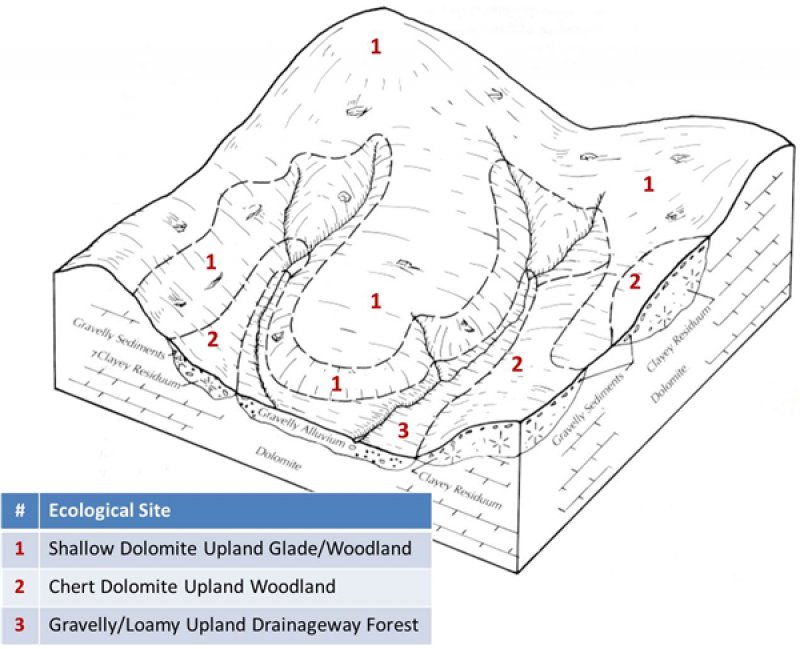
Figure 2. Landscape relationships for this ecological site.
Table 2. Representative physiographic features
| Landforms |
(1)
Ridge
(2) Hill (3) Hillslope |
|---|---|
| Flooding frequency | None |
| Slope | 3 – 15% |
| Water table depth | 99 in |
| Aspect | W, SE, S, SW |
Climatic features
The Ozark Highland has a continental type of climate marked by strong seasonality. In winter, dry-cold air masses, unchallenged by any topographic barriers, periodically swing south from the northern plains and Canada. If they invade reasonably humid air, snowfall and rainfall result. In summer, moist, warm air masses, equally unchallenged by topographic barriers, swing north from the Gulf of Mexico and can produce abundant amounts of rain, either by fronts or by convectional processes. In some summers, high pressure stagnates over the region, creating extended droughty periods. Spring and fall are transitional seasons when abrupt changes in temperature and precipitation may occur due to successive, fast-moving fronts separating contrasting air masses.
The Ozark Highland experiences regional differences in climates, but these differences do not have obvious geographic boundaries. Regional climates grade inconspicuously into each other. The basic gradient for most climatic characteristics is along a line crossing the MLRA from northwest to southeast.
The average annual precipitation in almost all of this area is 38 to 45 inches. Snow falls nearly every winter, but the snow cover lasts for only a few days. The average annual temperature is about 53 to 60 degrees F. The lower temperatures occur at the higher elevations in the western part of the MLRA. Mean January minimum temperature follows a stronger north-to-south gradient. However, mean July maximum temperature shows hardly any geographic variation in the MLRA. Mean July maximum temperatures have a range of only two or three degrees across the area.
Mean annual precipitation varies along a northwest to southeast gradient. Seasonal climatic variations are more complex. Seasonality in precipitation is very pronounced due to strong continental influences. June precipitation, for example, averages three to four times greater than January precipitation. Most of the rainfall occurs as high-intensity, convective thunderstorms in summer.
During years when precipitation comes in a fairly normal manner, moisture is stored in the top layers of the soil during the winter and early spring, when evaporation and transpiration are low. During the summer months the loss of water by evaporation and transpiration is high, and if rainfall fails to occur at frequent intervals, drought will result. Drought directly affects plant and animal life by limiting water supplies, especially at times of high temperatures and high evaporation rates.
Superimposed upon the basic MLRA climatic patterns are local topographic influences that create topoclimatic, or microclimatic variations. In regions of appreciable relief, for example, air drainage at nighttime may produce temperatures several degrees lower in valley bottoms than on side slopes. At critical times during the year, this phenomenon may produce later spring or earlier fall freezes in valley bottoms. Deep sinkholes often have a microclimate significantly cooler, moister, and shadier than surrounding surfaces, a phenomenon that may result in a strikingly different ecology. Higher daytime temperatures of bare rock surfaces and higher reflectivity of these unvegetated surfaces may create distinctive environmental niches such as glades and cliffs. Slope orientation is an important topographic influence on climate. Summits and south-and-west-facing slopes are regularly warmer and drier than adjacent north- and-east-facing slopes. Finally, the climate within a canopied forest is measurably different from the climate of a more open grassland or savanna areas.
Source: University of Missouri Climate Center - http://climate.missouri.edu/climate.php; Land Resource Regions and Major Land Resource Areas of the United States, the Caribbean, and the Pacific Basin, United States Department of Agriculture Handbook 296 - http://soils.usda.gov/survey/geography/mlra/
Table 3. Representative climatic features
| Frost-free period (characteristic range) | 154-180 days |
|---|---|
| Freeze-free period (characteristic range) | 190-207 days |
| Precipitation total (characteristic range) | 44-47 in |
| Frost-free period (actual range) | 146-185 days |
| Freeze-free period (actual range) | 186-208 days |
| Precipitation total (actual range) | 43-48 in |
| Frost-free period (average) | 167 days |
| Freeze-free period (average) | 198 days |
| Precipitation total (average) | 45 in |
Figure 3. Monthly precipitation range
Figure 4. Monthly minimum temperature range
Figure 5. Monthly maximum temperature range
Figure 6. Monthly average minimum and maximum temperature
Figure 7. Annual precipitation pattern
Figure 8. Annual average temperature pattern
Climate stations used
-
(1) POTOSI 4 SW [USC00236826], Potosi, MO
-
(2) TRUMAN DAM & RSVR [USC00238466], Warsaw, MO
-
(3) EUREKA SPRINGS 3 WNW [USC00032356], Eureka Springs, AR
-
(4) MTN HOME 1 NNW [USC00035036], Mountain Home, AR
Influencing water features
This ecological site is not influenced by wetland or riparian water features. Nearly all precipitation leaves this site as runoff, due to the shallow soils and underlying impermeable dolomite bedrock. Even though soils are shallow, vegetation sparse and slopes steep, storm hydrographs show that interflow is a major contributor to total storm runoff. Unlike those from most semi-pervious areas, storm hydrographs have rapid overland flow concentration, sharp peaks, and long tapering overland flow concentration (Gates and others 1982). A small amount infiltrates the bedrock along fracture planes, recharging local groundwater and feeding Ozark springs. Management has only a minor effect on this process, as the underlying bedrock is the primary hydrologic barrier.
Soil features
These soils are underlain with dolomite bedrock at less than 20 inches. The soils were formed under prairie vegetation, and have dark, organic-rich surface horizons. Parent material is dolomite residuum. These soils are loamy to clayey and are skeletal, with high amounts of dolomite gravel, channers and flagstones. They are not affected by seasonal wetness. Soil series associated with this site include Gasconade, Knobby, Moko, and Opequon.
The accompanying picture of a roadcut in the Moko series shows the shallow depth to the fractured dolomite bedrock that characterizes this ecological site. Picture from Baker (1998).
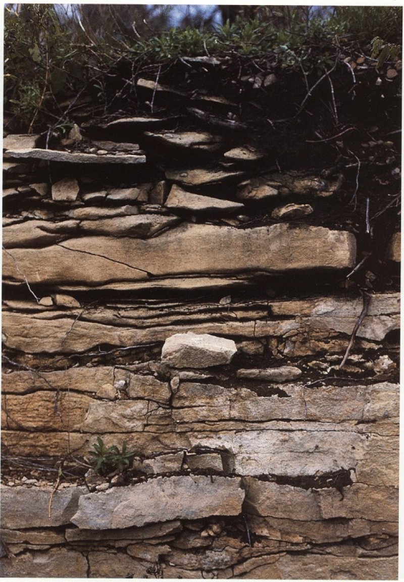
Figure 9. Moko series
Table 4. Representative soil features
| Parent material |
(1)
Residuum
–
dolomite
|
|---|---|
| Surface texture |
(1) Gravelly clay loam (2) Very gravelly silty clay loam (3) Very cobbly loam |
| Family particle size |
(1) Clayey |
| Drainage class | Well drained to somewhat excessively drained |
| Permeability class | Very slow |
| Soil depth | 4 – 20 in |
| Surface fragment cover <=3" | 7 – 55% |
| Surface fragment cover >3" | 2 – 60% |
| Available water capacity (0-40in) |
1 – 2 in |
| Calcium carbonate equivalent (0-40in) |
Not specified |
| Electrical conductivity (0-40in) |
2 mmhos/cm |
| Sodium adsorption ratio (0-40in) |
Not specified |
| Soil reaction (1:1 water) (0-40in) |
6.1 – 7.8 |
| Subsurface fragment volume <=3" (Depth not specified) |
5 – 40% |
| Subsurface fragment volume >3" (Depth not specified) |
5 – 50% |
Ecological dynamics
Information contained in this section was developed using historical data, professional experience, field reviews, and scientific studies. The information is representative of very complex vegetation communities. Not all scenarios or plants are included or discussed. Key indicator plants, animals and ecological processes are described to help guide land management decisions. Plant communities will differ across the MLRA because of the naturally occurring variability in weather, soils, and aspect. The Reference Plant Community is not necessarily the management goal. The biological processes on this site are complex. Therefore, representative values are presented in a land management context. The species lists are representative and are not botanical descriptions of all species occurring, or potentially occurring, on this site. They are not intended to cover every situation or the full range of conditions, species, and responses for the site.
Dolomite glades are open, rocky areas with very shallow soils dominated by drought-adapted herbaceous flora, generally occurring on south-and west-facing slopes of otherwise wooded sites (Nelson 2010). One of the most striking aspects of dolomite glades is their unique and characteristic flora. Many plants have an affinity for calcareous dolomite substrates. Glade plants in general possess many adaptations enabling them to survive in a harsh environment often subject to widely fluctuating extremes of temperature and moisture. The following conditions are general characteristic of most dolomite glades (Nelson and Ladd 1983; Nelson et al. 2013):
• Calcareous dolomite bedrock at or near the surface as a result of major erosional activity and resistance to weathering;
• Moderate to steep slopes in deeply dissected drainages or hilly to mountainous terrain with a southern or western exposure with intense solar radiation;
• Extremely thin soil cover interspersed with abundant rock fragments and rock outcrops;
• Exceptionally dry conditions throughout much of the growing season, although soils may be seasonally saturated in spring, winter, and fall;
• Peripheral areas and sometimes large expanses of the glades themselves characterized by a mosaic of stunted, often gnarled trees and shrubs.
Fire, drought, frost upheaval, and native grazers were the primary natural disturbances on pre-settlement glades. It is likely that these sites burned at least once every 3 to five years (Guyette and McGinnes 1982). These periodic fires removed the litter and stimulated the growth and flowering of the grasses and forbs. They also limited the growth and dominance of trees, especially eastern redcedar. Fire tolerant chinkapin oak (Quercus muehlenbergii) and post oak (Quercus stellata) occupied islands and edges where the deeper range of the soil component occurred, creating a complex mosaic of open glade and low-density woodland. During fire-free intervals, woody species increased, but not to densities on over-grazed or fire-excluded glades.
In the long term absence of fire, woody species, especially eastern redcedar (Juniperus virginiana), quickly occupy the site. This is especially true after grazing has reduced grass cover and exposed more surface to the dispersal of cedar seeds by birds. Once established, eastern redcedar will quickly fill in a glade/woodland system, especially if grazing has diminished the vigor of the diverse flora. Many current glades have been heavily grazed and suffer substantial eastern redcedar invasion along with many exotic species such as yellow sweet clover (Melilotus officinale), tall fescue (Schedonorus arundinaceus) and common teasel (Dipsacus fullonum). Removal of the eastern redcedar and the application of herbicides and prescribed fire have proven to be an effect way to manage these systems (Nelson, et al. 2013).
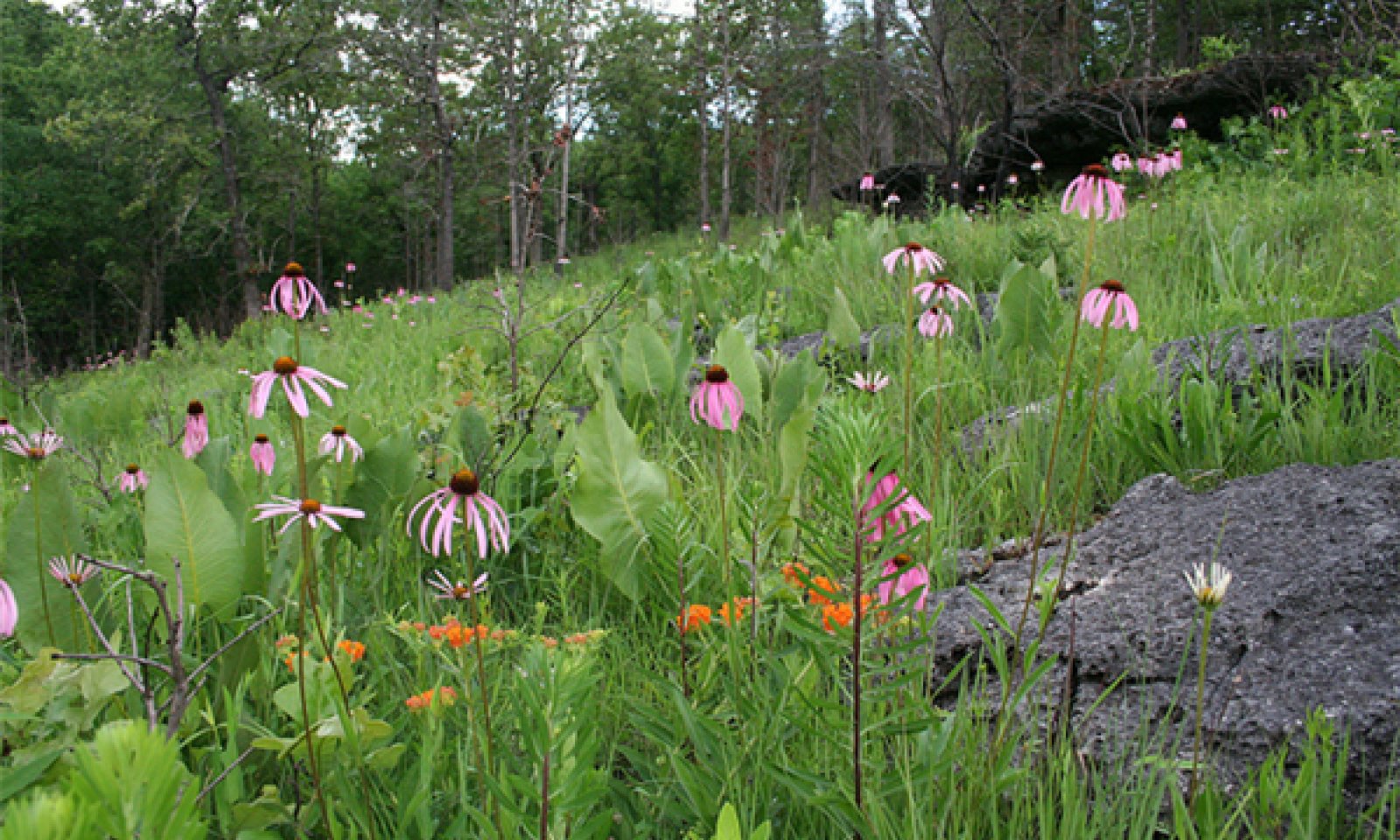
Dolomite glade/woodland systems harbor a wide diversity of plants and animals. Common native prairie grasses that are present include little bluestem (Schizachyrium scoparium), Indian grass (Sorghastrum nutans), and sideoats grama (Bouteloua curtipendula), which are also found on deeper soil prairies. But other species, such as Missouri coneflower (Rudbeckia missouriensis) and calamint (Calamintha arkansana), shown in the photo on the left, are only found on these dolomite glades. Lichens may be locally abundant. Desert-adapted animals, like lizards, scorpions and tarantulas, also occupy healthy glades (Missouri Department of Conservation 2014; Sexton 1982).
Dolomite glades in the different watersheds in the Ozark Highlands exhibit unique subsets of characteristic species. The floral glade assemblage of the White River Hills watershed contains several southwestern species at the eastern edge of their range. These include Trelease’s delphinium (Delphinium treleasei), Ashe’s juniper (Juniperus ashei), soap weed (Yucca arkansana) and American smoke tree (Cotinus obovatus), along with species of conservation concern such as western soapberry (Sapindus drummondii), umbrella plant (Eriogonum longifolium), and purple tassels prairie clover (Dalea gattingeri). Missouri bladderpod (Physaria filiformis) and Bush’s skullcap (Scutellaria bushii) are also endemic glade plants of the Ozark highlands (Yatskievych 1999; Nelson 2010; Nelson, et al. 2013; Nigh and Schroeder 2002).
Dolomite glades of the Ozark Highlands also provide valuable habitat for priority or watch-listed bird species, including the field sparrow (Spizella pusilla), brown thrasher (Toxostoma rufum), and painted bunting (Passerina ciris) (Jacobs 2001). The greater roadrunner (Geococcyx californicus), shown in the photo, is the only bird largely restricted to the dolomite glades in southwestern Missouri. Bachman’s sparrow (Aimophila aestivalis) is often found on dolomite glades. The Texas mouse (Peromyscus attwateri) is the only mammal restricted to glades in Missouri (Schwartz et al. 2001).
The presence of restricted animals, including insects, presents a challenge, when using prescribed burning as a management tool. While the use of fire existed prior to European settlement, for populations to remain viable in a fire mediated landscape, today’s intensively altered watersheds may impose greater stress on certain plant and animal populations when using fire in contemporary confined landscapes (e.g. small tracts, lack of landscape connectivity, public-private conflicts) (Nelson, et al. 2013).
Finally, of growing concern are the feral hog numbers that are dramatically increasing throughout the Ozark Highlands. Feral hogs dig and overturn extensive vegetation mats on glades looking for insects, reptiles, small mammals, and plant roots. This results in extensive rutting that increases soil erosion and loss of plant and animal species diversity
A state and transition model diagram for the Shallow Dolomite Upland Glade/Woodland Ecological Site (R116AY020MO) follows this narrative. Descriptions of each state, transition, plant community, and pathway follow the model. Experts base this model on available experimental research, field observations, professional consensus, and interpretations. It is likely to change as knowledge increases. The following diagram suggests some pathways that the vegetation on this site might take. There may be other states not shown on the diagram. This information is intended to show what might happen in a given set of circumstances. It does not mean that this would happen the same way in every instance. Local professional guidance should always be sought before pursuing a treatment scenario.
State and transition model
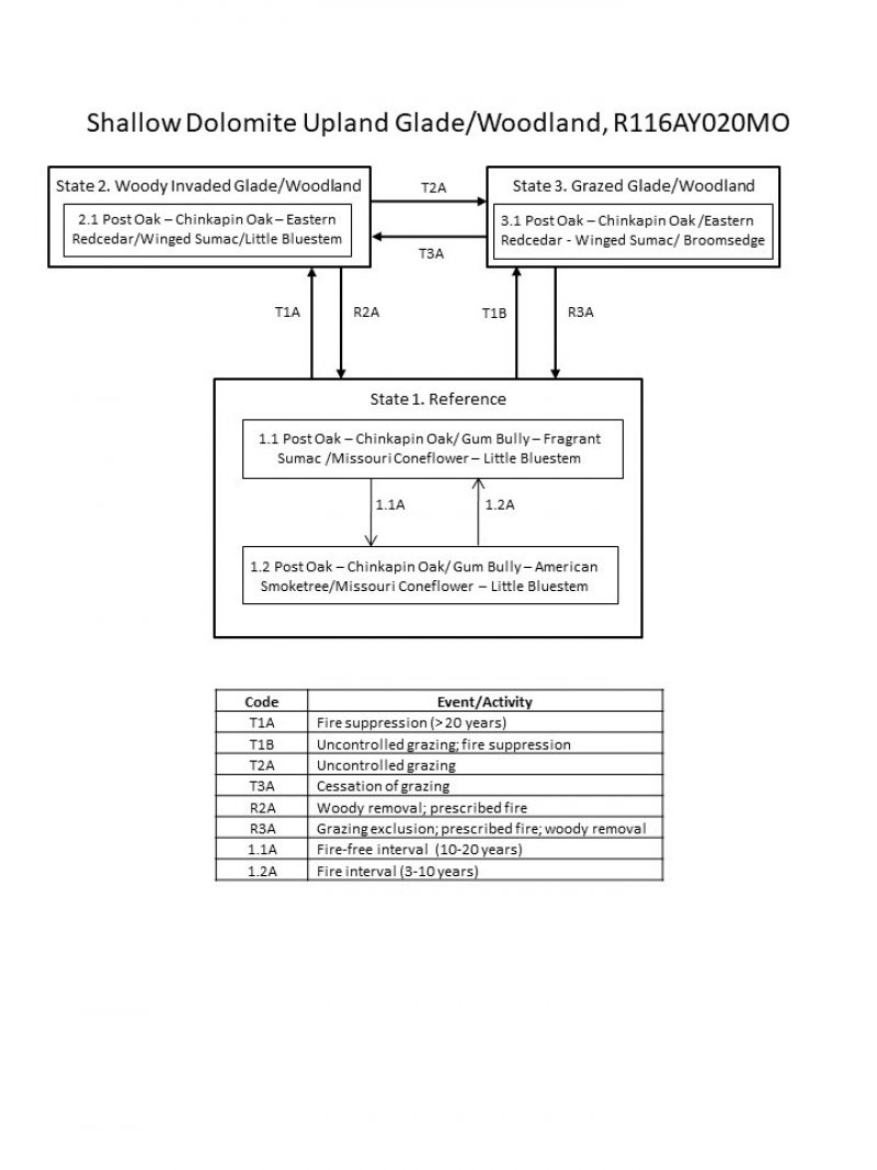
Figure 10. State and transition diagram for this ecological site.
More interactive model formats are also available.
View Interactive Models
More interactive model formats are also available.
View Interactive Models
Click on state and transition labels to scroll to the respective text
Ecosystem states
State 2 submodel, plant communities
State 3 submodel, plant communities
State 1
Reference
The reference state can be found in scattered locations throughout the Ozark Highlands. The reference state ranges from wide open grassy areas with shallow soils and bare bedrock, to areas with widely scattered chinkapin oak and post oak on locations with soil depths at the deeper extreme of the range for this soil component. On protected slopes and along the outer edges of glades, open woodlands are more common. Here the deeper soil depth range for this soil component and protected aspects allow more woody components to dominate. Periodic disturbances from fire maintained the dominance of drought adapted native grasses and forbs by limiting the growth and dominance of trees, especially eastern redcedar. Long disturbance-free periods allowed an increase in woody species. Two community phases are recognized in this state, with shifts between phases based on fire frequency. With decreasing fire frequency, a shift to Community Phase 1.2 will occur and exhibit an increase in woody densities.
Community 1.1
Post Oak – Chinkapin Oak/ Gum Bully – Fragrant Sumac /Missouri Coneflower – Little Bluestem

Figure 11. Reference state glade at Peck Ranch Conservation Area, north of Fremont, Missouri. Photo credit - MDC
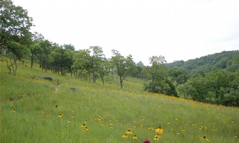
Figure 12. Reference state glade at Ha Ha Tonka State Park near Lake of the Ozarks in Missouri. Photo credit - MODNR
This phase has widely scattered chinkapin oak and post oak with little bluestem, side oats grama, and sedges (Carex spp.) dominating the open ground layer. Numerous forbs such as coneflower and lichens are also present and locally abundant. Bedrock outcropping is common.
Forest overstory. Overstory Species list is based on field reconnaissance as well as commonly occurring species listed in Nelson 2010; names and symbols are from USDA PLANTS database.
Forest understory. Understory Species list is based on field reconnaissance as well as commonly occurring species listed in Nelson 2010; names and symbols are from USDA PLANTS database.
Table 5. Ground cover
| Tree foliar cover | 0.00-0.99% |
|---|---|
| Shrub/vine/liana foliar cover | 0.0-0.1% |
| Grass/grasslike foliar cover | 0.1-25.0% |
| Forb foliar cover | 0.01-2.00% |
| Non-vascular plants | 0.01-0.99% |
| Biological crusts | 0.01-5.00% |
| Litter | 1-25% |
| Surface fragments >0.25" and <=3" | 0.01-50.00% |
| Surface fragments >3" | 0.01-50.00% |
| Bedrock | 0.01-50.00% |
| Water | 0% |
| Bare ground | 0.1-50.0% |
Table 6. Soil surface cover
| Tree basal cover | 0% |
|---|---|
| Shrub/vine/liana basal cover | 0% |
| Grass/grasslike basal cover | 0% |
| Forb basal cover | 0% |
| Non-vascular plants | 0% |
| Biological crusts | 0% |
| Litter | 1-25% |
| Surface fragments >0.25" and <=3" | 0% |
| Surface fragments >3" | 0% |
| Bedrock | 0% |
| Water | 0% |
| Bare ground | 0% |
Table 7. Woody ground cover
| Downed wood, fine-small (<0.40" diameter; 1-hour fuels) | 0-0% N* |
|---|---|
| Downed wood, fine-medium (0.40-0.99" diameter; 10-hour fuels) | 0-0% N* |
| Downed wood, fine-large (1.00-2.99" diameter; 100-hour fuels) | 0-0% N* |
| Downed wood, coarse-small (3.00-8.99" diameter; 1,000-hour fuels) | 0-0% N* |
| Downed wood, coarse-large (>9.00" diameter; 10,000-hour fuels) | 0% |
| Tree snags** (hard***) | – |
| Tree snags** (soft***) | – |
| Tree snag count** (hard***) | |
| Tree snag count** (hard***) | 0-10 per acre |
* Decomposition Classes: N - no or little integration with the soil surface; I - partial to nearly full integration with the soil surface.
** >10.16cm diameter at 1.3716m above ground and >1.8288m height--if less diameter OR height use applicable down wood type; for pinyon and juniper, use 0.3048m above ground.
*** Hard - tree is dead with most or all of bark intact; Soft - most of bark has sloughed off.
Table 8. Canopy structure (% cover)
| Height Above Ground (ft) | Tree | Shrub/Vine | Grass/ Grasslike |
Forb |
|---|---|---|---|---|
| <0.5 | 0% | 0% | 1-95% | 0-25% |
| >0.5 <= 1 | 0-1% | 0-1% | 0-50% | 0-25% |
| >1 <= 2 | 0-25% | 0-5% | 0-25% | 0-25% |
| >2 <= 4.5 | 0-10% | 0-2% | 0-5% | 0-2% |
| >4.5 <= 13 | 0-5% | – | – | – |
| >13 <= 40 | 1-2% | – | – | – |
| >40 <= 80 | – | – | – | – |
| >80 <= 120 | – | – | – | – |
| >120 | – | – | – | – |
Community 1.2
Post Oak – Chinkapin Oak/ Gum Bully – American Smoketree/Missouri Coneflower – Little Bluestem
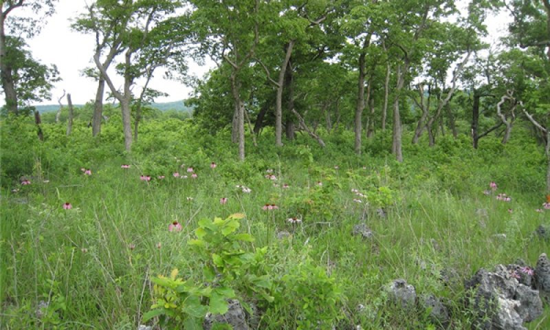
Figure 13. Reference state with lower fire frequency at Ha Ha Tonka State Park near Lake of the Ozarks in Missouri. Photo credit - MDC
This phase is similar to community phase 1.1 but post oak, chinkapin oak and numerous shrubs are increasing due to longer periods of fire suppression. Some displacement of grasses and forbs may be occurring due to shading and competition from the increased densities of shrubs and oaks.
Pathway 1.1A
Community 1.1 to 1.2


This pathway results from fire suppression. With fire-free intervals of 10 to 20 years, woody species will increase in density and cover causing the community to gradually shift to phase 1.2 Some displacement of grasses and forbs may be occurring due to shading and competition from the increased densities of shrubs and oaks.
Pathway 1.2A
Community 1.2 to 1.1


With increased fire frequencies, woody species will decrease in density and cover, and over time, this community will gradually shift back to community phase 1.1.
Conservation practices
| Prescribed Burning |
|---|
State 2
Woody Invaded Glade/Woodland
This state is dominated by eastern redcedar with significant increases of oak density due to extended or permanent periods of fire suppression. This state can form relatively even-age stands, dating to when fire suppression began. Canopy closures can approach 50 to 80 percent with little or no ground flora.
Community 2.1
Post Oak – Chinkapin Oak – Eastern Redcedar/Winged Sumac/Little Bluestem
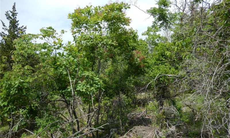
Figure 14. A dolomite glade in Arkansas being invaded by woody species due to lack of fire. Photo credit - Doug Wallace, NRCS
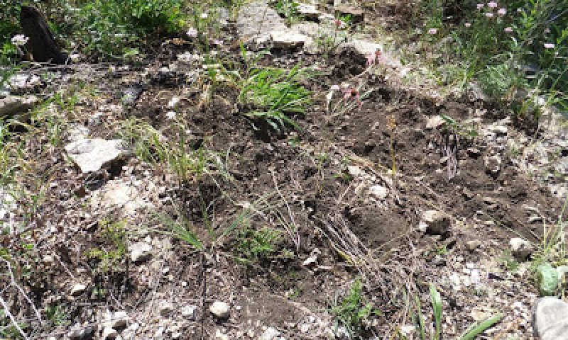
Figure 15. Feral hog damage on a dolomite glade in the White River watershed; photo credit NRCS
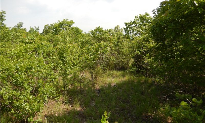
Figure 16. A dolomite glade in Arkansas being invaded by woody species due to lack of fire. Photo credit - Doug Wallace, NRCS
This phase is dominated by eastern redcedar and numerous shrub species. They can form relatively even-age stands, dating to when fire suppression began. This stage can occur relatively quickly (10 to 20 years). Canopy closures can approach 50 to 80 percent with little or no ground flora under the overstory canopy. Without active management, such as prescribed fire and woody removal, these sites will continue increasing in canopy coverage except on the shallowest soil and open bedrock areas where droughty conditions often keep woody invasion in check.
State 3
Heavily Grazed Glade/Woodland
Overgrazing can erode the shallow, fragile, original soil layer from glades. This overgrazing will decrease the number and diversity of species and cause changes in the distribution of opportunistic and conservative glade species. Eastern redcedar along with many exotic species such as yellow sweet clover (Melilotus latissimus), tall fescue (Schedonorus arundinaceus), cheat grass (Bromus tectorum) and common teasel (Dipsacus laciniatus) readily invade grazed dolomite glades. Grazing animals also reduce the quality of glade and barrens habitat through soil compaction and the selective removal of plant species essential to the survival of glade insects (Erickson et al. 1942).
Community 3.1
Post Oak – Chinkapin Oak /Eastern Redcedar - Winged Sumac/ Broomsedge
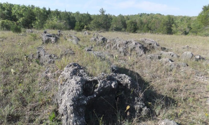
Figure 17. Heavily grazed dolomite glade near Decaturville, Missouri. Photo credit - Allison Vaughn
Due to long periods of domestic livestock grazing grass and forb diversity and ground cover are severly reduced increasing the potential for soil erosion and increased water runoff. This phase may also have increased densities of eastern redcedar, oak, and shrubs. Other weedy species such as non-native grasses and forbs also increase.
Transition T1A
State 1 to 2
This gradual transition results from prolonged periods of fire suppression, generally over 20 years.
Conservation practices
| Brush Management | |
|---|---|
| Prescribed Burning |
Transition T1B
State 1 to 3
This transition results from persistent cattle grazing accompanied by fire suppression.
Restoration pathway R2A
State 2 to 1
Restoration requires cutting most of the invading woody species such as eastern redcedar, accompanied by prescribed fire on a continued basis.
Conservation practices
| Brush Management | |
|---|---|
| Prescribed Burning |
Transition T2A
State 2 to 3
This transition results from long periods of uncontrolled domestic livestock grazing.
Restoration pathway R3A
State 3 to 1
Restoration requires exclusion of livestock grazing, accompanied by prescribed burning and brush managment.
Conservation practices
| Brush Management | |
|---|---|
| Prescribed Burning | |
| Access Control |
Transition T3A
State 3 to 2
This gradual transition results from the sessation of grazing by domestic livestock.
Additional community tables
Table 9. Community 1.1 forest overstory composition
| Common name | Symbol | Scientific name | Nativity | Height (ft) | Canopy cover (%) | Diameter (in) | Basal area (square ft/acre) |
|---|---|---|---|---|---|---|---|
|
Tree
|
|||||||
| post oak | QUST | Quercus stellata | Native | – | 0–5 | – | – |
| chinquapin oak | QUMU | Quercus muehlenbergii | Native | – | 0–5 | – | – |
| American smoketree | COOB2 | Cotinus obovatus | Native | – | 0–5 | – | – |
| dwarf hackberry | CETE | Celtis tenuifolia | Native | – | 0–5 | – | – |
Table 10. Community 1.1 forest understory composition
| Common name | Symbol | Scientific name | Nativity | Height (ft) | Canopy cover (%) | |
|---|---|---|---|---|---|---|
|
Grass/grass-like (Graminoids)
|
||||||
| little bluestem | SCSC | Schizachyrium scoparium | Native | – | – | |
| puffsheath dropseed | SPNE2 | Sporobolus neglectus | Native | – | – | |
| big bluestem | ANGE | Andropogon gerardii | Native | – | – | |
| sideoats grama | BOCU | Bouteloua curtipendula | Native | – | – | |
| rough dropseed | SPCL | Sporobolus clandestinus | Native | – | – | |
| Indiangrass | SONU2 | Sorghastrum nutans | Native | – | – | |
| switchgrass | PAVI2 | Panicum virgatum | Native | – | – | |
| hairy fimbry | FIPU | Fimbristylis puberula | Native | – | – | |
| Heller's rosette grass | DIOL | Dichanthelium oligosanthes | Native | – | – | |
| arrowfeather threeawn | ARPU8 | Aristida purpurascens | Native | – | – | |
| composite dropseed | SPCO16 | Sporobolus compositus | Native | – | – | |
| fewflower nutrush | SCPA5 | Scleria pauciflora | Native | – | – | |
| slender woodland sedge | CADI5 | Carex digitalis | Native | – | – | |
| bristleleaf sedge | CAEB2 | Carex eburnea | Native | – | – | |
| rock muhly | MUSO | Muhlenbergia sobolifera | Native | – | – | |
| hairy woodland brome | BRPU6 | Bromus pubescens | Native | – | – | |
| Mead's sedge | CAME2 | Carex meadii | Native | – | – | |
| Crawe's sedge | CACR3 | Carex crawei | Native | – | – | |
| parasol sedge | CAUM4 | Carex umbellata | Native | – | – | |
|
Forb/Herb
|
||||||
| Missouri orange coneflower | RUMI | Rudbeckia missouriensis | Native | – | – | |
| diamond-flowers | STNI6 | Stenaria nigricans | Native | – | – | |
| prairie rosinweed | SITE | Silphium terebinthinaceum | Native | – | – | |
| limestone calamint | CLAR5 | Clinopodium arkansanum | Native | – | – | |
| fewleaf sunflower | HEOC2 | Helianthus occidentalis | Native | – | – | |
| Ontario blazing star | LICY | Liatris cylindracea | Native | – | – | |
| aromatic aster | SYOB | Symphyotrichum oblongifolium | Native | – | – | |
| skyblue aster | SYOO | Symphyotrichum oolentangiense | Native | – | – | |
| tall blazing star | LIAS | Liatris aspera | Native | – | – | |
| widowsfrill | SIST | Silene stellata | Native | – | – | |
| yellow pimpernel | TAIN | Taenidia integerrima | Native | – | – | |
| golden zizia | ZIAU | Zizia aurea | Native | – | – | |
| tall thoroughwort | EUAL3 | Eupatorium altissimum | Native | – | – | |
| Ozark milkvetch | ASDI4 | Astragalus distortus | Native | – | – | |
| butterfly milkweed | ASTU | Asclepias tuberosa | Native | – | – | |
| spiked crested coralroot | HESP3 | Hexalectris spicata | Native | – | – | |
| Curtis' star-grass | HYCU5 | Hypoxis curtissii | Native | – | – | |
| crowpoison | NOBI2 | Nothoscordum bivalve | Native | – | – | |
| slimflower scurfpea | PSTE5 | Psoralidium tenuiflorum | Native | – | – | |
| smooth rockcress | ARLA | Arabis laevigata | Native | – | – | |
| groovestem Indian plantain | ARPL4 | Arnoglossum plantagineum | Native | – | – | |
| groundplum milkvetch | ASCRT | Astragalus crassicarpus var. trichocalyx | Native | – | – | |
| western silver aster | SYSE2 | Symphyotrichum sericeum | Native | – | – | |
| branched noseburn | TRRA5 | Tragia ramosa | Native | – | – | |
| Gattinger's goldenrod | SOGA | Solidago gattingeri | Native | – | – | |
| gray goldenrod | SONE | Solidago nemoralis | Native | – | – | |
| fringeleaf wild petunia | RUHU | Ruellia humilis | Native | – | – | |
| smooth blue aster | SYLA3 | Symphyotrichum laeve | Native | – | – | |
| small palafox | PACA3 | Palafoxia callosa | Native | – | – | |
| wild quinine | PAHI8 | Parthenium hispidum | Native | – | – | |
| Michaux's stitchwort | MIMI2 | Minuartia michauxii | Native | – | – | |
| Nuttall's sensitive-briar | MINU6 | Mimosa nuttallii | Native | – | – | |
| hairy sunflower | HEHI2 | Helianthus hirsutus | Native | – | – | |
| hogwort | CRCA6 | Croton capitatus | Native | – | – | |
| prairie tea | CRMO6 | Croton monanthogynus | Native | – | – | |
| purple prairie clover | DAPU5 | Dalea purpurea | Native | – | – | |
| pasture heliotrope | HETE3 | Heliotropium tenellum | Native | – | – | |
| grooved flax | LISU4 | Linum sulcatum | Native | – | – | |
| common cinquefoil | POSI2 | Potentilla simplex | Native | – | – | |
| slimflower scurfpea | PSTE5 | Psoralidium tenuiflorum | Native | – | – | |
| Buckley's goldenrod | SOBU | Solidago buckleyi | Native | – | – | |
| marbleseed | ONOSM | Onosmodium | Native | – | – | |
| lanceleaf tickseed | COLA5 | Coreopsis lanceolata | Native | – | – | |
| stiff tickseed | COPA10 | Coreopsis palmata | Native | – | – | |
| Indianhemp | APCA | Apocynum cannabinum | Native | – | – | |
| downy gentian | GEPU5 | Gentiana puberulenta | Native | – | – | |
| rose mock vervain | GLCA2 | Glandularia canadensis | Native | – | – | |
| wavyleaf purple coneflower | ECSI | Echinacea simulata | Native | – | – | |
| western rough goldenrod | SORA | Solidago radula | Native | – | – | |
| autumn onion | ALST | Allium stellatum | Native | – | – | |
| flowering spurge | EUCO10 | Euphorbia corollata | Native | – | – | |
| hoary puccoon | LICA12 | Lithospermum canescens | Native | – | – | |
| Atlantic camas | CASC5 | Camassia scilloides | Native | – | – | |
| downy pagoda-plant | BLCI | Blephilia ciliata | Native | – | – | |
| scarlet Indian paintbrush | CACO17 | Castilleja coccinea | Native | – | – | |
| bastard toadflax | COUM | Comandra umbellata | Native | – | – | |
| annual ragweed | AMAR2 | Ambrosia artemisiifolia | Native | – | – | |
| slender threeseed mercury | ACMO4 | Acalypha monococca | Native | – | – | |
| prairie fleabane | ERST3 | Erigeron strigosus | Native | – | – | |
| narrowleaf gumweed | GRLA3 | Grindelia lanceolata | Native | – | – | |
| slimleaf milkweed | ASST | Asclepias stenophylla | Native | – | – | |
| whorled milkweed | ASVE | Asclepias verticillata | Native | – | – | |
| green comet milkweed | ASVI | Asclepias viridiflora | Native | – | – | |
| slender yellow woodsorrel | OXDI2 | Oxalis dillenii | Native | – | – | |
| violet woodsorrel | OXVI | Oxalis violacea | Native | – | – | |
| narrowleaf stoneseed | LIIN2 | Lithospermum incisum | Native | – | – | |
| largeflower fameflower | PHCA48 | Phemeranthus calycinus | Native | – | – | |
| Virginia groundcherry | PHVI5 | Physalis virginiana | Native | – | – | |
| Nuttall's prairie parsley | PONU4 | Polytaenia nuttallii | Native | – | – | |
| blackeyed Susan | RUHI2 | Rudbeckia hirta | Native | – | – | |
| false aloe | MAVI5 | Manfreda virginica | Native | – | – | |
| trailing lespedeza | LEPR | Lespedeza procumbens | Native | – | – | |
| creeping lespedeza | LERE2 | Lespedeza repens | Native | – | – | |
| slender lespedeza | LEVI7 | Lespedeza virginica | Native | – | – | |
| Dillenius' ticktrefoil | DEGL4 | Desmodium glabellum | Native | – | – | |
| sessileleaf ticktrefoil | DESE | Desmodium sessilifolium | Native | – | – | |
| Lady Bird's centaury | CETE2 | Centaurium texense | Native | – | – | |
| partridge pea | CHFA2 | Chamaecrista fasciculata | Native | – | – | |
| spotted sandmat | CHMA15 | Chamaesyce maculata | Native | – | – | |
| stiff ticktrefoil | DEOB5 | Desmodium obtusum | Native | – | – | |
| poorjoe | DITE2 | Diodia teres | Native | – | – | |
| Bush's purple coneflower | ECPA2 | Echinacea paradoxa | Native | – | – | |
| shaggy dwarf morning-glory | EVNU | Evolvulus nuttallianus | Native | – | – | |
| hairy bedstraw | GAPI2 | Galium pilosum | Native | – | – | |
| American ginseng | PAQU | Panax quinquefolius | Native | – | – | |
| purple cliffbrake | PEAT2 | Pellaea atropurpurea | Native | – | – | |
| pale beardtongue | PEPA7 | Penstemon pallidus | Native | – | – | |
| thickleaf phlox | PHCA19 | Phlox carolina | Native | – | – | |
| pitcher's stitchwort | MIPA6 | Minuartia patula | Native | – | – | |
| bigfruit evening primrose | OEMA | Oenothera macrocarpa | Native | – | – | |
| prairie goldenrod | OLAL2 | Oligoneuron album | Native | – | – | |
| Bush's skullcap | SCBU | Scutellaria bushii | Native | – | – | |
| sleepy silene | SIAN2 | Silene antirrhina | Native | – | – | |
| prairie blue-eyed grass | SICA9 | Sisyrinchium campestre | Native | – | – | |
| Great Plains lady's tresses | SPMA5 | Spiranthes magnicamporum | Native | – | – | |
| smooth violet prairie aster | SYTU2 | Symphyotrichum turbinellum | Native | – | – | |
| fluxweed | TRBR5 | Trichostema brachiatum | Native | – | – | |
| feverwort | TRPE5 | Triosteum perfoliatum | Native | – | – | |
| narrowleaf vervain | VESI | Verbena simplex | Native | – | – | |
| birdfoot violet | VIPE | Viola pedata | Native | – | – | |
| meadow zizia | ZIAP | Zizia aptera | Native | – | – | |
| roundhead lespedeza | LECA8 | Lespedeza capitata | Native | – | – | |
| false boneset | BREU | Brickellia eupatorioides | Native | – | – | |
|
Shrub/Subshrub
|
||||||
| fragrant sumac | RHAR4 | Rhus aromatica | Native | – | – | |
| gum bully | SILA20 | Sideroxylon lanuginosum | Native | – | – | |
| coralberry | SYOR | Symphoricarpos orbiculatus | Native | – | – | |
| winged sumac | RHCO | Rhus copallinum | Native | – | – | |
| Carolina rose | ROCA4 | Rosa carolina | Native | – | – | |
| smooth sumac | RHGL | Rhus glabra | Native | – | – | |
| leadplant | AMCA6 | Amorpha canescens | Native | – | – | |
| rusty blackhaw | VIRU | Viburnum rufidulum | Native | – | – | |
|
Tree
|
||||||
| chinquapin oak | QUMU | Quercus muehlenbergii | Native | – | – | |
| common persimmon | DIVI5 | Diospyros virginiana | Native | – | – | |
| winged elm | ULAL | Ulmus alata | Native | – | – | |
| Shumard's oak | QUSH | Quercus shumardii | Native | – | – | |
| dwarf hackberry | CETE | Celtis tenuifolia | Native | – | – | |
| slippery elm | ULRU | Ulmus rubra | Native | – | – | |
| common hoptree | PTTR | Ptelea trifoliata | Native | – | – | |
|
Vine/Liana
|
||||||
| saw greenbrier | SMBO2 | Smilax bona-nox | Native | – | – | |
| eastern poison ivy | TORA2 | Toxicodendron radicans | Native | – | – | |
| Alabama supplejack | BESC | Berchemia scandens | Native | – | – | |
| summer grape | VIAE | Vitis aestivalis | Native | – | – | |
| fiveangled dodder | CUPE3 | Cuscuta pentagona | Native | – | – | |
| eastern milkpea | GARE2 | Galactia regularis | Native | – | – | |
| Virginia creeper | PAQU2 | Parthenocissus quinquefolia | Native | – | – | |
|
Nonvascular
|
||||||
| fishscale lichen | PSDE60 | Psora decipiens | Native | – | – | |
| Calkins' wart lichen | VECA14 | Verrucaria calkinsiana | Native | – | – | |
| Russell's fishscale lichen | PSRU3 | Psora russellii | Native | – | – | |
Table 11. Community 1.2 forest overstory composition
| Common name | Symbol | Scientific name | Nativity | Height (ft) | Canopy cover (%) | Diameter (in) | Basal area (square ft/acre) |
|---|---|---|---|---|---|---|---|
|
Tree
|
|||||||
| post oak | QUST | Quercus stellata | Native | – | 1–5 | – | – |
| chinquapin oak | QUMU | Quercus muehlenbergii | Native | – | 1–5 | – | – |
| eastern redcedar | JUVI | Juniperus virginiana | Native | – | 0–2 | – | – |
Interpretations
Animal community
Wildlife
Wildlife habitat: oaks provide hard mast; numerous native legumes provide high-quality wildlife food; native warm-season grasses provide extensive cover and nesting habitat; and a diversity of forbs provides a diversity and abundance of insects. Post-burn areas can provide temporary bare-ground – herbaceous cover habitat important for turkey poults and quail chicks.
Game species that utilize this ecological site include:
Northern Bobwhite will utilize this ecological site for food (seeds, insects), cover needs (escape, nesting and roosting cover) and brood-rearing habitat.
Cottontail rabbits will utilize this ecological site for food (seeds, soft mast) and cover needs.
Turkey will utilize this ecological site for food (seeds, green browse, soft mast, and insects) and nesting and brood-rearing cover. Turkey poults feed heavily on insects provided by this site type.
White-tailed Deer will utilize this ecological site for browse (plant leaves in the growing season, seeds and soft mast in the fall/winter). (Pitts and McGuire 2000; Schwartz, et al. 2001)
Breeding bird species associated with this ecological site’s reference state condition:
Field Sparrow, Yellow-breasted Chat, Blue-winged Warbler, Brown Thrasher, Indigo Bunting, Red-headed Woodpecker, Eastern Bluebird, Northern Bobwhite, Prairie Warbler, and Eastern Towhee. In the White River watershed these additional species may be present: Painted Bunting, Greater Roadrunner, and Bachman’s Sparrow. (Fitzgerald and Pashley 2000a; Jacobs 2001)
Amphibian and reptile species that may be associated with this ecological site’s reference state: collared lizard (Crotaphytus collaris collaris), five-lined skink (Eumeces fasciatus), six-lined racerunner (Cnemidophorus sexlineatus), flat-headed snake (Tantilla gracilis), eastern coachwhip (Masticophis flagellum flagellum), red milk snake (Lampropeltis triangulum syspila), eastern narrow-mouthed toad (Gastrophyne carolinensis), coal skink (Eumeces anthracinus pluvialis), ground snake (Snora semiannulata), western pygmy rattlesnake (Sistrurus miliarius streckeri) and prairie ring-necked snake (Diadophis punctatus arnyi). (Johnson 2000)
Small mammals likely associated with this ecological site’s reference state condition: eastern woodrat (Neotoma floridana) and Peromyscus species. In the White River watershed, the Texas mouse (Peromyscus attwateri) occurs. (Schwartz, et al. 2001)
Invertebrates – Many native insect species are likely associated with this ecological site’s reference state condition, especially native bees, ants, beetles, butterflies and moths, and crickets, grasshoppers and katydids.
Insect species likely associated with this ecological site’s reference state condition: dusted skipper butterfly (Atrytonopsis hianna), cobweb skipper butterfly (Hesperia metea), pepper and salt skipper butterfly (Amblyscirtes hegon), delaware skipper butterfly (Atryone logan logan), crossline skipper butterfly (Polites origenes), native ants (Pheidole tysoni, Formica schaufussi), and native bees (Colletes aestivalis, Andrena helianthiformis, Protandrena rudbeckiae, Lasioglossum coreopsis, Anthidium psoraleae and Dianthidium subrufulum). In the White River watershed, the largest tiger beetle in the state occurs on these sites, Cicindela obsoleta vulturina. (Heitzman and Heitzman, 1996)
Other invertebrates: black widow spider (Latrodectus mactans), Texas brown tarantula (Aphonopelma hentzi) and striped bark scorpion (Centruroides vittatus)
(This section was developed by Mike Leahy, Natural Areas Coordinator, Missouri Department of Conservation, 2013)
Hydrological functions
Nearly all precipitation leaves this site as runoff, due to the shallow soils and underlying impermeable dolomite bedrock. Even though soils are shallow, vegetation sparse and slopes steep, storm hydrographs show that interflow is a major contributor to total storm runoff. Unlike those from most semi-pervious areas, storm hydrographs have rapid overland flow concentration, sharp peaks, and long tapering overland flow concentration (Gates and others 1982). A small amount infiltrates the bedrock along fracture planes, recharging local groundwater and feeding Ozark springs. Management has only a minor effect on this process, as the underlying bedrock is the primary hydrologic barrier.
Recreational uses
Hiking and wildlife viewing are the primary recreational uses of this ecological site. Endemic plants, birds, and reptiles, wildflower displays, and often spectacular views across the Ozark landscape make well-managed sites uniquely attractive for visitors. Poorly managed sites, where fire exclusion and grazing have resulted in cedar encroachment, do not offer these features, and have limited recreational value.
Wood products
Forest Management
Field measured site index values are 22 to 34 for eastern redcedar and 34 to 38 for chinkapin oak. Productivity is very low. No practical timber management opportunities exist. These sites are valuable for wildlife purposes and watershed protection. Severely reduced rooting depth restricts tree growth and increases windthrow hazards. These sites respond well to prescribed fire as a management tool.
Other information
Site Limitations: Surface stones and surface rock; very shallow soil depth. Surface stones and rocks are problems for efficient and safe equipment operation. Severe seedling mortality due to high soil surface temperatures and low available water holding capacity is possible. Machine planting and mechanical site preparation is not recommended. Hard bedrock at shallow depths may interfere with equipment operation. Rock outcrops may cause breakage of timber when harvesting. Surface stones and rocks will make equipment use extremely difficult. Erosion is a hazard when slopes exceed 15 percent. Equipment use is not recommended.
Supporting information
Inventory data references
Potential Reference Sites: Shallow Dolomite Upland Glade/Woodland
Plot CAMOCA01
Located in Caney Mountain Conservation Area, Ozark County, MO.
Latitude: 36.677194
Longitude: 92.390578
Plot CAMOCA07
Located in Caney Mountain Conservation Area, Ozark County, MO
Latitude: 36.698095
Longitude: 92.455858
Plot HATOSP01
Located in Ha Ha Tonka State Park, Camden, MO.
Latitude: 37.982841
Longitude: 92.764619
Plot HATOSP02
Located in Ha Ha Tonka State Park, Camden, MO.
Latitude: 37.982616
Longitude: 92.764864
Plot HATOSP05
Located in Ha Ha Tonka State Park, Camden, MO.
Latitude: 37.96363
Longitude: 92.763162
Plot MERASP01
Located in Meramec State Park, Crawford County, MO.
Latitude: 38.194715
Longitude: 91.107875
Plot PERACA02
Located in Peck Ranch Conservation Area, Carter County, MO.
Latitude: 37.038814
Longitude: 91.161315
Plot PERACA03
Located in Peck Ranch Conservation Area, Carter County, MO.
Latitude: 37.039494
Longitude: 91.161128
May 2014: Reconnaissance work in Arkansas:
Harold E. Alexander Spring River Wildlife Management Area (Sharp County, west of Ash Flat)
Carrollton Glade (Bull Shoals Lake, NW of Lead Hill, Boone County); Jim Turbo property (NW Baxter County)
Type locality
| Location 1: Carter County, MO | |
|---|---|
| Township/Range/Section | T27N R2W S3 |
| UTM zone | N |
| UTM northing | 4100759 |
| UTM easting | 663524 |
| Latitude | 37° 2′ 19″ |
| Longitude | 91° 9′ 40″ |
| General legal description | Plot PERACA02 Peck Ranch Conservation Area Knobby pedon |
| Location 2: Carter County, MO | |
| Township/Range/Section | T27N R2W S3 |
| UTM zone | N |
| UTM northing | 4100835 |
| UTM easting | 663539 |
| Latitude | 37° 2′ 22″ |
| Longitude | 91° 9′ 40″ |
| General legal description | Plot PERACA03 Peck Ranch Conservation Area Opequon pedon |
| Location 3: Ozark County, MO | |
| Township/Range/Section | T23N R13W S16 |
| UTM zone | N |
| UTM northing | 4059236 |
| UTM easting | 554453 |
| Latitude | 36° 40′ 37″ |
| Longitude | 92° 23′ 26″ |
| General legal description | Plot CAMOCA01 Caney Mountain Conservation Area |
| Location 4: Ozark County, MO | |
| Township/Range/Section | T23N R14W S1 |
| UTM zone | N |
| UTM northing | 4061520 |
| UTM easting | 548607 |
| Latitude | 36° 41′ 53″ |
| Longitude | 92° 27′ 21″ |
| General legal description | Plot CAMOCA07 Caney Mountain Conservation Area |
| Location 5: Camden County, MO | |
| Township/Range/Section | T38N R17W S35 |
| UTM zone | N |
| UTM northing | 4203937 |
| UTM easting | 520671 |
| Latitude | 37° 58′ 58″ |
| Longitude | 92° 45′ 52″ |
| General legal description | Plot HATOSP01 Ha Ha Tonka State Park Knobby pedon |
| Location 6: Camden County, MO | |
| Township/Range/Section | T37N R17W S11 |
| UTM zone | N |
| UTM northing | 4201806 |
| UTM easting | 520804 |
| Latitude | 37° 57′ 49″ |
| Longitude | 92° 45′ 47″ |
| General legal description | Plot HATOSP05 Ha Ha Tonka State Park Knobby pedon |
| Location 7: Camden County, MO | |
| Township/Range/Section | T38N R17W S35 |
| UTM zone | N |
| UTM northing | 4203912 |
| UTM easting | 520649 |
| Latitude | 37° 58′ 57″ |
| Longitude | 92° 45′ 53″ |
| General legal description | Plot HATOSP02 Ha Ha Tonka State Park Knobby pedon |
| Location 8: Crawford County, MO | |
| Township/Range/Section | T40N R2W S23 |
| UTM zone | N |
| UTM northing | 4229111 |
| UTM easting | 665690 |
| Latitude | 38° 11′ 40″ |
| Longitude | 91° 6′ 28″ |
| General legal description | Plot MERASP01 Meramec State Park Knobby pedon |
Other references
Anderson, R.C. 1990. The historic role of fire in North American grasslands. Pp. 8-18 in S.L. Collins and L.L. Wallace (eds.). Fire in North American tallgrass prairies. University of Oklahoma Press, Norman.
Baker, J. L. 1998. Soil Survey of Cooper County, Missouri. U.S. Dept. of Agric. Natural Resources Conservation Service.
Batek, M.J., A.J. Rebertus, W.A. Schroeder, T.L. Haithcoat, E. Compas, and R.P. Guyette. 1999. Reconstruction of early nineteenth-century vegetation and fire regimes in the Missouri Ozarks. Journal of Biogeography 26:397-412.
Dodd, J. A., & E. J. Dettman. 1996. Soil Survey of Taney County, Missouri. U.S. Dept. of Agric. Natural Resources Conservation Service.
Erickson, R. O., L. G. Brenner, and J. Wraight. 1942. Dolomitic glades of east-central Missouri. Annals of the Missouri Botanical Garden 29(2):89-101.
Fitzgerald, J.A. and D.N. Pashley. 2000a. Partners in Flight bird conservation plan for the Ozark/Ouachitas. American Bird Conservancy.
Guyette, R.P. and E.A. McGinnes, Jr. 1982. Fire history of an Ozark glade in Missouri.
Transactions of the Missouri Academy of Science 16: 85-89.
Harlan, J.D., T.A. Nigh and W.A. Schroeder. 2001. The Missouri original General Land Office survey notes project. University of Missouri, Columbia.
Heitzman, J.R. and J.E. Heitzman. 1996. Butterflies and moths of Missouri. 2nd ed. Missouri Department of Conservation, Jefferson City.
Jacobs, B. 2001. Birds in Missouri. Missouri Department of Conservation, Jefferson City.
Janowski-Bell, M.E. 2001. Ecology of an American tarantula, Aphonopelma hentzi (Girard) (Theraphosidae). Ph.D. dissertation, University of Missouri, Columbia.
Johnson, T.R. 2000. The amphibians and reptiles of Missouri. 2nd ed. Missouri Department of Conservation, Jefferson City.
Missouri Department of Conservation. Retrieved July 2014. Field Guide: Missouri Tarantula. http://mdc.mo.gov/discover-nature/field-guide/missouri-tarantula
NatureServe. 2014. International Ecological Classification Standard: Terrestrial Ecological
Classifications. NatureServe Central Databases. Arlington, VA USA, Data current as of July 9,
2014.
Nelson, P.W. 2010. The terrestrial natural communities of Missouri. Missouri Natural Areas
Committee, Jefferson City, Missouri. 550 pp.
Nelson P.W. and D. Ladd. 1983. Preliminary report on the identification, distribution, and classification of Missouri glades. Pp. 59-76 in C.L. Kucera (ed.). Proceedings of the seventh North American Prairie Conference. Southwest Missouri State University, Springfield, Missouri.
Nelson, P. W., J. A. Fitzgerald, K. Larson, R. McCoy, A. Schotz, J. Taft, T. Witsell, B. Yahn. 2013. Central Hardwoods Joint Venture Glade Conservation Assessment for the Interior Highlands and Interior Low Plateaus of the Central Hardwoods Region. Central Hardwoods Joint Venture. http://www.chjv.org/projects.html.
Nigh, T. A. and W. A. Schroeder. 2002. Atlas of Missouri Ecoregions. Missouri Department of Conservation, Jefferson City, Missouri.
Pitts, D.E. and W.D. McGuire. 2000. Wildlife management for Missouri landowners. 3rd ed. Missouri Department of Conservation, Jefferson City.
Schoolcraft, H.R. 1821. Journal of a tour into the interior of Missouri and Arkansas from Potosi, or Mine a Burton, in Missouri territory, in a southwest direction, toward the Rocky Mountains: performed in the years 1818 and 1819. Richard Phillips and Company, London.
Schwartz, C.W., E.R. Schwartz and J.J. Conley. 2001. The wild mammals of Missouri. University of Missouri Press, Columbia and Missouri Department of Conservation, Jefferson City.
Sexton, O.J. 1982. Life history notes on the terrestrial vertebrates inhabiting some glades of eastern Missouri with emphasis on amphibians and reptiles. Proceedings of the cedar glade symposium, Missouri Academy of Science, Occasional Paper 7:21-55.
United States Department of Agriculture – Natural Resource Conservation Service (USDA-NRCS). 2006. Land Resource Regions and Major Land Resource Areas of the United States, the Caribbean, and the Pacific Basin. U.S. Department of Agriculture Handbook 296. 682 pgs.
Yatskievych, G. 1999. Steyermark’s Flora of Missouri, Volume 1. Revised edition. Missouri
Department of Conservation in cooperation with the Missouri Botanical Garden Press, St. Louis, Missouri.
Contributors
Doug Wallace
Fred Young
Approval
Suzanne Mayne-Kinney, 12/18/2024
Acknowledgments
Missouri Department of Conservation and Missouri Department of Natural Resources personnel provided significant and helpful field and technical support in the development of this ecological site.
Rangeland health reference sheet
Interpreting Indicators of Rangeland Health is a qualitative assessment protocol used to determine ecosystem condition based on benchmark characteristics described in the Reference Sheet. A suite of 17 (or more) indicators are typically considered in an assessment. The ecological site(s) representative of an assessment location must be known prior to applying the protocol and must be verified based on soils and climate. Current plant community cannot be used to identify the ecological site.
| Author(s)/participant(s) |
Douglas Wallace NRCS ACES Ecologist |
|---|---|
| Contact for lead author |
Parkade Center NRCS 601 Business Loop 70 West Columbia, MO 65203 |
| Date | 07/28/2014 |
| Approved by | Suzanne Mayne-Kinney |
| Approval date | |
| Composition (Indicators 10 and 12) based on | Foliar Cover |
Indicators
-
Number and extent of rills:
Rills are rare due to the extensive rock outcrops and stoney nature of the surface. -
Presence of water flow patterns:
Water flows in interstitial areas between bedrock occurrences. -
Number and height of erosional pedestals or terracettes:
rare; < 1 inch in height -
Bare ground from Ecological Site Description or other studies (rock, litter, lichen, moss, plant canopy are not bare ground):
Areas of bare ground exist. When present they are generally underneath and associated with woody species that have shaded out other vegetation. -
Number of gullies and erosion associated with gullies:
none -
Extent of wind scoured, blowouts and/or depositional areas:
none -
Amount of litter movement (describe size and distance expected to travel):
minimal - little surface litter is present -
Soil surface (top few mm) resistance to erosion (stability values are averages - most sites will show a range of values):
Soil surface is minimal in most areas. Sites are dominated by rock outcrops, stones, boulders and cobbly surfaces. -
Soil surface structure and SOM content (include type of structure and A-horizon color and thickness):
0-6 inches very dark grayish brown; SOM <2% -
Effect of community phase composition (relative proportion of different functional groups) and spatial distribution on infiltration and runoff:
Low due to low plant densities. Runoff rates can be high due to the shallow soil depths, large areas of bedrock outcropping and stoney nature of the ground surface. -
Presence and thickness of compaction layer (usually none; describe soil profile features which may be mistaken for compaction on this site):
None -
Functional/Structural Groups (list in order of descending dominance by above-ground annual-production or live foliar cover using symbols: >>, >, = to indicate much greater than, greater than, and equal to):
Dominant:
Warm season grasses > forbs > sedgesSub-dominant:
Other:
shrubsAdditional:
-
Amount of plant mortality and decadence (include which functional groups are expected to show mortality or decadence):
All plant species should be capable of reproduction depending on water availibility. All plants should be vigorous, healthy and reproductive depending on disturbance (e.g., drought). Plants should have numerous seed heads, vegetative tillers etc.
The only limitations are weather-related effects, wildfire, and natural disease that may temporarily reduce reproductive capability. Plant mortality can be high due to droughty conditions and high sun exposure during summer months. -
Average percent litter cover (%) and depth ( in):
-
Expected annual annual-production (this is TOTAL above-ground annual-production, not just forage annual-production):
less than 200 pounds per acre per year -
Potential invasive (including noxious) species (native and non-native). List species which BOTH characterize degraded states and have the potential to become a dominant or co-dominant species on the ecological site if their future establishment and growth is not actively controlled by management interventions. Species that become dominant for only one to several years (e.g., short-term response to drought or wildfire) are not invasive plants. Note that unlike other indicators, we are describing what is NOT expected in the reference state for the ecological site:
eastern redcedar, smooth sumac, sweet clover, tall fescue, teasel -
Perennial plant reproductive capability:
Better in normal to wet years and seasons. Poorer in dry years and seasons.
Print Options
Sections
Font
Other
The Ecosystem Dynamics Interpretive Tool is an information system framework developed by the USDA-ARS Jornada Experimental Range, USDA Natural Resources Conservation Service, and New Mexico State University.
Click on box and path labels to scroll to the respective text.