Natural Resources
Conservation Service
Ecological site NX118AY009
Sandy Bottomland
Last updated: 1/03/2019
Accessed: 02/15/2026
General information
Provisional. A provisional ecological site description has undergone quality control and quality assurance review. It contains a working state and transition model and enough information to identify the ecological site.

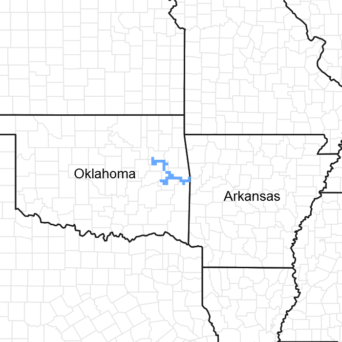
Figure 1. Mapped extent
Areas shown in blue indicate the maximum mapped extent of this ecological site. Other ecological sites likely occur within the highlighted areas. It is also possible for this ecological site to occur outside of highlighted areas if detailed soil survey has not been completed or recently updated.
MLRA notes
Major Land Resource Area (MLRA): 118A–Arkansas Valley and Ridges, Eastern Part
118A—Arkansas Valley and Ridges, Eastern Part Major Land Resource Area (MLRA) is in Arkansas (75 percent) and Oklahoma (25 percent) encompassing an area of approximately 6,755 square miles (17,510 square kilometers). The towns of Poteau and Sallisaw, OK, and Booneville, Clarksville, Fort Smith, Greenwood, and Ozark, AR, are in the western part. The Arkansas towns of Conway, Morrilton, Russellville, and Searcy are in the eastern section along with a part of Little Rock in the southeast corner. Interstate 40 passes through from east to west and parallels the northern side of the Arkansas River. The Ozark National Forest and the northern fringe of the Ouachita National Forest occur in this area as does Ft. Chaffee, Camp Joseph T. Robinson, and Little Rock Air Force Base (USDA 2006).
Most of 118A is in the Arkansas Valley Section of the Ouachita Province of the Interior Highlands. Long, narrow ridges and high flat-topped mountains capped with sandstone trend northeastward. Crests are narrow and rolling on ridges and broad and flat on mountaintops. The intervening valleys are broad and smooth. Elevation ranges from 300 ft. (90 m) on the lowest valley floors to 2,750 ft. (840 m) on the mountaintops. The Arkansas River is a major inland navigational river. It flows from the northwestern part of the MLRA, at Robert S. Kerr Lake, in Oklahoma to Little Rock in the southeast.
The ridges and valleys of 118A are underlain by slightly folded to level beds of sandstone and shale, respectively. The area principally consists of the following geologic groups: Savanna, McAlester, Hartshorne sandstone, and the upper and lower Atoka. These are of Pennsylvanian age (formed approximately 300 million years ago). The terrace deposits along the Arkansas River include a complex sequence of unconsolidated gravel, sandy gravel, sands, silty sands, silts, clayey silts, and clays. At least three terrace levels are recognized. The lowest is the youngest.
Classification relationships
This ecological site is found in Major Land Resource Area 118A - the Arkansas Valley and Ridges, Eastern Part. MLRA 118A is located within Land Resource Region N - the East and Central Farming and Forest Region (USDA 2006). In addition, MLRA118A falls within area #37 of EPA Ecoregion Level III - the Arkansas Valley (USEPA 2013). The Sandy Bottomland ecological site occurs in United States Forest Service Ecoregions -255A – the Prairie Parkland (Subtropical) Province, and in M222A – the Ozark Broadleaf Forest-Meadow Province (Bailey 1995). This ecological site is found primarily in 37b - Arkansas River Floodplain of EPA Ecoregion IV (Woods et. al. 1996).
South-Central Interior Large Floodplain - CES202.705
(NatureServe 2017).
Ecological site concept
The Sandy Bottomland ecological site is of limited extent, and occurs on flood plains, stream terraces, and point bars along the Arkansas River floodplain within the Arkansas Valley and Ridges Major Land Resource Area. Floodplain forests and oak woodlands occupied much of this ecological site. Although vegetation was variable, typical species included Acer saccharinum (silver maple), Platanus occidentalis (American sycamore), Liquidambar styraciflua (sweetgum), and Quercus spp. (oaks). Typical understory grassland species included Schizachyrium scoparium (little bluestem). Close to 23 percent of this ecological site has been converted to pasture and hay land. At least 13 percent is used for row crops. This ecological is much drier and sandier than the Loamy Bottomland and the Calcareous Bottomland ecological sites. It is less naturally fertile than the Calcareous Bottomland.
Associated sites
| NX118A01Y007 |
Seasonally Wet Terraces and Footslopes |
|---|
Similar sites
| F119XY013AR |
Loamy Floodplain |
|---|
Table 1. Dominant plant species
| Tree |
(1) Quercus macrocarpa |
|---|---|
| Shrub |
Not specified |
| Herbaceous |
Not specified |
Legacy ID
F118AY009OK
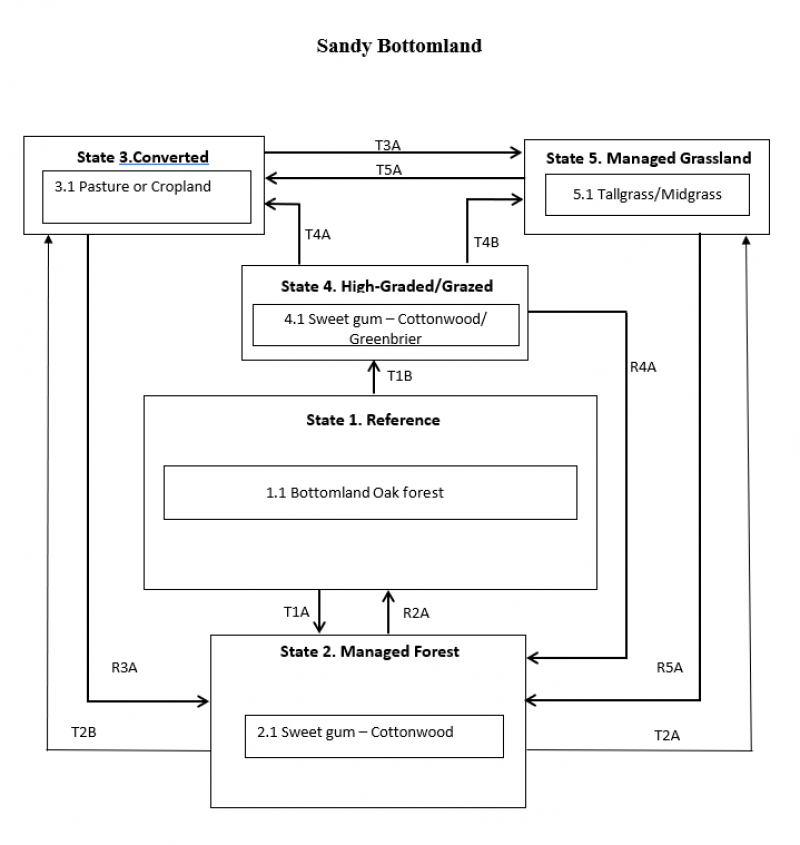
Click on box and path labels to scroll to the respective text.
Ecosystem states
States 2 and 5 (additional transitions)
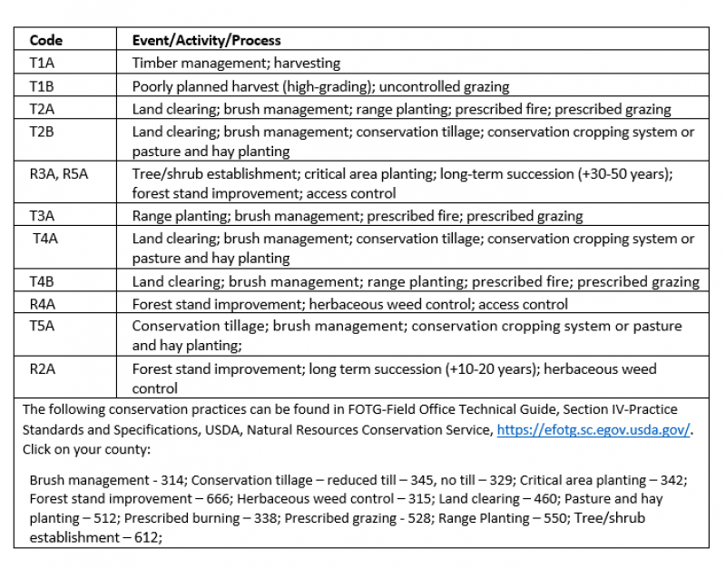
| T1A | - | Timber management; harvesting |
|---|---|---|
| T1B | - | Poorly planned harvest (high-grading); uncontrolled grazing |
| R2A | - | Forest stand improvement; long term succession (+10-20 years); herbaceous weed control |
| T2B | - | Land clearing; brush management; conservation tillage; conservation cropping system or pasture and hay planting |
| T2A | - | Land clearing; brush management; range planting; prescribed fire; prescribed grazing |
| R3A | - | Tree/shrub establishment; critical area planting; long-term succession (+30-50 years); forest stand improvement; access control |
| T3A | - | Range planting; brush management; prescribed fire; prescribed grazing |
| R4A | - | Forest stand improvement; herbaceous weed control; access control |
| T4A | - | Land clearing; brush management; conservation tillage; conservation cropping system or pasture and hay planting |
| T4B | - | Land clearing; brush management; range planting; prescribed fire; prescribed grazing |
| R5A | - | Tree/shrub establishment; critical area planting; long-term succession (+30-50 years); forest stand improvement; access control |
| T5A | - | Conservation tillage; brush management; conservation cropping system or pasture and hay planting; |

