Natural Resources
Conservation Service
Ecological site F119XY004AR
Loamy Wet Depression
Accessed: 02/06/2026
General information
Provisional. A provisional ecological site description has undergone quality control and quality assurance review. It contains a working state and transition model and enough information to identify the ecological site.

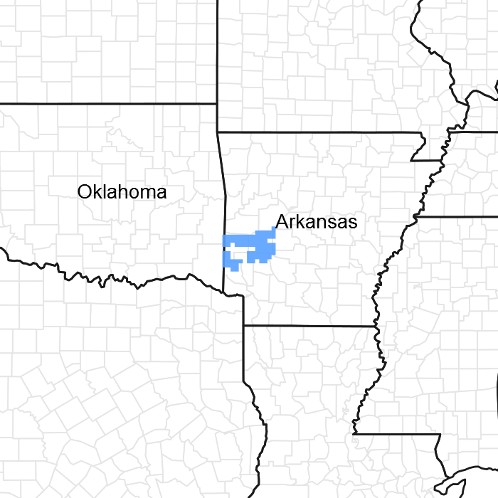
Figure 1. Mapped extent
Areas shown in blue indicate the maximum mapped extent of this ecological site. Other ecological sites likely occur within the highlighted areas. It is also possible for this ecological site to occur outside of highlighted areas if detailed soil survey has not been completed or recently updated.
MLRA notes
Major Land Resource Area (MLRA): 119X–Ouachita Mountains
This ecological site is found in MLRA 119: Ouachita Mountains.
This area is in the Ouachita Mountains Section of the Ouachita Province of the Interior Highlands. The steep mountains are underlain by folded and faulted sedimentary and metamorphic rocks. Most of the stream valleys are narrow and have steep gradients, but wide terraces and flood plains border the Ouachita River in western Arkansas. Elevation ranges from 330 feet (100 meters) on the lowest valley floors to 2,625 feet (800 meters) on the highest mountain peaks. Local relief is generally 100 to 200 feet (30 to 60 meters), but it can exceed 980 feet (300 meters).
Classification relationships
Nature Serve area Ozark-Ouachita Shortleaf Pine-Bluestem Woodland.
Summary: This system represents woodlands of the Ouachita and Ozark mountains region of Arkansas, adjacent Oklahoma, and southern Missouri in which Pinus echinata is the canopy dominant, and the understory is characterized by Andropogon gerardii, Schizachyrium scoparium, and other prairie plants. Although examples of this system occur throughout this region, there is local variation in the extent to which they were present. The center of distribution is the northern and western Ouachita Mountains, and it is best developed in large, dry, and flat to gently undulating portions of the landscape which carry fire well, creating extensive natural fire compartments. In the Ouachitas, the system occurs on the northern Hogback Ridges excluding the Novaculite areas to the south. These are large, gently sloping, east/west-trending ridges of sandstone and shale, the south-facing slopes of which constitute large fire compartments. In nearly all examples, Pinus echinata occurs with a variable mixture of hardwood species. The exact composition of the hardwoods is much more closely related to aspect and topographic factors than is the pine component. In the Ozark Highlands this system is less extensive but was historically prominent where sandstone-derived soils are common. In Missouri and Oklahoma, this system occurs on gently dissected upland cherty plains (in addition to sandstone ridges).
Notes: LandFire is a complex, model-based system of estimating current and potential vegetation on a national basis. The LandFire system contains a peer-reviewed and spatially-oriented vegetation database that can be compared to NRCS SSURGO soil data and used in the development of provisional ecological sites (PES).
LandFire vegetation coverages have been developed under a partnership of multiple federal agencies and non-profit ecological groups including NatureServe. The entire United States has been mapped using predictive landscape models based on field-referenced data, satellite imagery, and biophysical gradient layers.
LandFire uses computer modeling to estimate vegetation reference conditions. Within the LandFire system, the Biophysical Settings (BpS) layer represents the vegetation that was likely dominant prior to European settlement. The BpS layer is based on the current environment and an approximation of the historical disturbance regime. The vegetation community descriptions derived from this computer modeling scenario may be in actuality be very rare or in some cases, non-existent, in the current environment.
Most LandFire vegetation coverages incorporate NatureServe's “Ecological Systems” classification thereby allowing users to access detailed descriptions of various ecological communities through the on-line NatureServe Explorer. Although these Ecological Systems are usually a larger scale than most PES groupings, the detailed plant community information found in these System descriptions can still augment PES narratives and provide assistance in state and transition model development.
Ecological site concept
This site is a wet depressional woodland on slopes less three percent with udic moisture and thermic temperature regimes. It has poorly and very poorly drained loamy soils.
Table 1. Dominant plant species
| Tree |
(1) Pinus echinata |
|---|---|
| Shrub |
Not specified |
| Herbaceous |
(1) Andropogon |
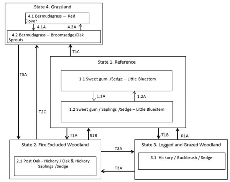
Click on box and path labels to scroll to the respective text.

