Natural Resources
Conservation Service
Ecological site R119XY075OK
Sandy Savannah
Accessed: 12/06/2025
General information
Provisional. A provisional ecological site description has undergone quality control and quality assurance review. It contains a working state and transition model and enough information to identify the ecological site.

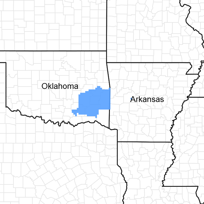
Figure 1. Mapped extent
Areas shown in blue indicate the maximum mapped extent of this ecological site. Other ecological sites likely occur within the highlighted areas. It is also possible for this ecological site to occur outside of highlighted areas if detailed soil survey has not been completed or recently updated.
MLRA notes
Major Land Resource Area (MLRA): 119X–Ouachita Mountains
This ecological site is found in MLRA 119: Ouachita Mountains.
This area is in the Ouachita Mountains Section of the Ouachita Province of the Interior Highlands. The steep mountains are underlain by folded and faulted sedimentary and metamorphic rocks. Most of the stream valleys are narrow and have steep gradients, but wide terraces and flood plains border the Ouachita River in western Arkansas. Elevation ranges from 330 feet (100 meters) on the lowest valley floors to 2,625 feet (800 meters) on the highest mountain peaks. Local relief is generally 100 to 200 feet (30 to 60 meters), but it can exceed 980 feet (300 meters).
Classification relationships
Crosstimbers Oak Forest and Woodland
Summary: This system is primarily found within central Texas and Oklahoma, ranging north to southeastern Kansas and east into eastern Oklahoma. It is distinct from the surrounding prairie by the higher density of tree species. The area consists of irregular plains with primarily sandy to loamy Ustalf soils that range from shallow to moderately deep. Rainfall can be moderate, but somewhat erratic, therefore moisture is often limiting during part of the growing season. Short, stunted Quercus stellata and Quercus marilandica characterize and dominate this system. Other species, such as Carya texana, Carya cordiformis, Quercus prinoides, Ulmus crassifolia, and other Quercus spp., can also be present within their respective ranges. The understory often contains species typical of the surrounding prairies, in particular Schizachyrium scoparium. Shrubs such as Rhus spp. may also be present. Drought, grazing, and fire are the primary natural processes that affect this system. Overgrazing and conversion to agriculture, along with fire suppression, have led to the invasion of some areas by problematic brush species such as Juniperus virginiana and Juniperus ashei and Prosopis glandulosa farther south in Texas and Oklahoma. It has also led to decreases in native grass cover allowing for annual grasses and forbs to invade.
Table 1. Dominant plant species
| Tree |
Not specified |
|---|---|
| Shrub |
Not specified |
| Herbaceous |
Not specified |
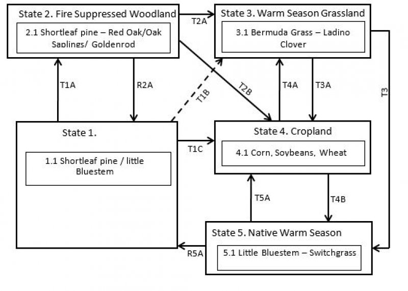
Click on box and path labels to scroll to the respective text.


