Natural Resources
Conservation Service
Ecological site F120CY006IN
Deep Moderately Well Drained Siltstone-Shale Uplands
Last updated: 10/01/2024
Accessed: 02/08/2026
General information
Provisional. A provisional ecological site description has undergone quality control and quality assurance review. It contains a working state and transition model and enough information to identify the ecological site.
MLRA notes
Major Land Resource Area (MLRA): 120C–Kentucky and Indiana Sandstone and Shale Hills and Valleys, Northeastern Part
120C—Kentucky and Indiana Sandstone and Shale Hills and Valleys, Northeastern Part
This area is entirely in Indiana and makes up about 1,050 square miles (2,725 square kilometers). Physiography: This area is in the Highland Rim Section of the Interior Low Plateaus Province of the Interior Plains. Both large and small tributaries of the Ohio River and the East Fork of the White River dissect the nearly level to very steep uplands in the area. The major streams and rivers have well defined valleys with broad flood plains and numerous stream terraces. The flood plains along the smaller streams are narrow. Summits are narrow and are nearly level to gently sloping. Geology: The geologic materials in this area are of Early and Middle Pennsylvanian and Late Mississippian age. The rocks consist mainly of flat-lying, interbedded sandstone, shale, coal, and siltstone with minor areas of limestone. Bedrock outcrops are common on the bluffs along the Ohio River and its major tributaries. The surficial geologic materials consist mainly of a layer of loess, typically less than 3.5 feet (1 meter) thick, on the less eroded parts of the landscape and stratified sediments of Pleistocene age along the Ohio River and its tributaries. Unconsolidated alluvium is deposited in the river valleys.
Soils: The dominant soil orders in this MLRA are Alfisols, Ultisols, and Inceptisols. The soils in the area have a mesic soil temperature regime, an udic or aquic soil moisture regime, and dominantly mixed mineralogy. They formed dominantly in loess and in residuum derived from siltstone and shale. They range from moderately deep to very deep and from somewhat poorly drained to well drained and are loamy, silty, or clayey. Fragiudults (Spickert and Tilsit series) and Hapludults (Wrays series) are the dominant soils on ridgetops and the upper parts of hills and knobs. Halpudalfs (Kurtz series), Hapludults (Gilwood and Gnawbone series), and Dystrudepts (Brownstown series) are on moderately sloping to very steep side slopes. Hapludalfs (Coolville, Rarden, Stonehead, and Wellrock series) are on the gently sloping to moderately steep lower parts of side slopes. Hapludalfs (Elkinsville series), Fragiudalfs (Pekin series), and Fragiaqualfs (Bartle series) are on stream terraces. Dystrudepts (Beanblossom, Cuba, and Steff series) and Endoaquepts (Stendal series) are on flood plains.
Classification relationships
Fagus grandifolia - Acer saccharum - Liriodendron tulipifera Unglaciated Forest
CEGL002411
Ecological site concept
The Deep Moderately Well Drained Siltstone-Shale Uplands ecological site is located on upland hills and benches. Representative soils include: Shircliff and Stonehead.
The communities described in this provisional document reflect plant communities that are likely to be found on these soils and have not been field verified. This PES describes hypotheses based on available data of many different scales and sources and has not been developed utilizing site-specific ecological field monitoring. This PES does not encompass the entire complexity or diversity of these sites. Field studies would be required to develop a comprehensive and science-based native plant restoration plan for these sites.
The hypotheses below were developed utilizing Purdue University data from the Hoosier National Forest (Andriy Vladimirovich Zhalnin and George R. Parker, 2007, Delineation and spatial analysis of ecological classification units for the Hoosier National Forest in Southern Indiana), NatureServe.org Explorer, VegBank.org, Plant Communities of the Midwest –Indiana Subset, and Indiana DNR.
Forest:
Aspect, topography, and soil depth will influence the gradient of communities on single mapunits. The herb dominance may show variation depending on aspect.
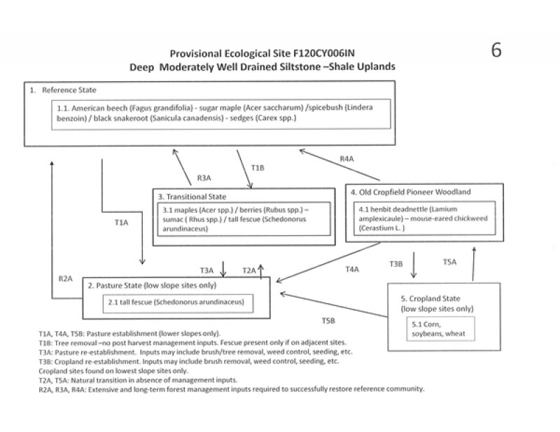
1.1. American beech (Fagus grandifolia) - sugar maple (Acer saccharum) /spicebush (Lindera benzoin)/black snakeroot (Sanicula canadensis) - sedges (Carex spp.)
Plant Communities of the Midwest (Indiana subset) describes these communities:
These sites will have diversity in the overstory, shrub layer and especially the herbaceous layer due to available water. Other trees on these sites may include Liriodendron tulipifera, Liquidambar styraciflua, Fraxinus americana, Quercus rubra, Carya glabra, and Carya cordiformis. Shrubs commonly found in this community are Asimina triloba and Lindera benzoin. Herbaceous species are diverse, forming a dense cover. They include Adiantum pedatum, Arisaema triphyllum, Asarum canadense, Carex blanda, Dicentra canadensis, Dioscorea quaternata, Galium circaezans, Menispermum canadense, Phegopteris hexagonoptera, Polystichum acrostichoides, and Sanguinaria canadensis. The large size of dominant canopy species (over 30 m tall), herbaceous diversity, and accumulated litter emphasize the high degree of mesophytism (TNC 1995a).
Purdue (Hoosier NF) found multiple species of Sanicula on sites associated with tulip trees, beech, and maples.
Pasture:
State 2, Phase 2.1. Plant species dominants: Schedonorus arundinaceus (tall fescue). Species present are dependent upon seeding and management.
Transitional Field: This phase is best described as an old field habitat with a mixture of native and introduced grasses, herbs, forbs, seedlings, and saplings.
State 3, Phase 3.1. maples (Acer spp.) / berries (Rubus spp.) – sumac ( Rhus spp.) / tall fescue (Schedonorus arundinaceus)
Cropland states were included in the state and transition model for the lower sloping sites only.
Abandoned Cropland (lower slopes only):
State 4 Phase 4.1. henbit deadnettle (Lamium amplexicaule) – mouse-eared chickweed (Cerastium L. )
Abandonment of cropland would result in many weed species taking over the site. Initially, annual weeds would be predominate followed by grasses, shrubs and pioneers trees.
Cropland: State: 5. Phase 5.1. Dependent upon seeding and management. Most common crops are corn and soybeans.
Associated sites
| F120CY005IN |
Moderately Deep Siltstone-Shale Uplands Moderately Deep Siltstone-Shale Uplands |
|---|---|
| F120CY007IN |
Deep Well Drained Siltstone-Shale Uplands Deep Well Drained Siltstone-shale Uplands |
Table 1. Dominant plant species
| Tree |
(1) Fagus grandifolia |
|---|---|
| Shrub |
(1) Lindera benzoin |
| Herbaceous |
(1) Sanicula canadensis |
Click on box and path labels to scroll to the respective text.
