Natural Resources
Conservation Service
Ecological site F121XY014KY
Poorly Drained & Very Poorly Drained Terrace Lakebed
Last updated: 10/01/2024
Accessed: 02/26/2026
General information
Provisional. A provisional ecological site description has undergone quality control and quality assurance review. It contains a working state and transition model and enough information to identify the ecological site.
MLRA notes
Major Land Resource Area (MLRA): 121X–Kentucky Bluegrass
General: MLRA 121 is in Kentucky (83 percent), southern Ohio (11 percent), and southern Indiana (6 percent). It makes up about 10,680 square miles (27,670 square kilometers). The cities of Cincinnati, Ohio, and Louisville, Frankfort, and Lexington, Kentucky, are in this area.
Physiography: This area is primarily in the Lexington Plain Section of the Interior Low Plateaus Province of the Interior Plains.
Soils: The dominant soil orders in MLRA 121 are Alfisols, Inceptisols, and Mollisols. The soils in the area dominantly have a mesic soil temperature regime, an udic soil moisture regime, and mixed mineralogy. They are shallow to very deep, generally well-drained, and loamy or clayey. Hapludalfs formed in residuum on hills and ridges (Beasley, Cynthiana, Eden, Faywood, Lowell, and McAfee series) and in loess over residuum on hills and ridges (Carmel and Shelbyville series). Paleudalfs (Crider and Maury series) formed in loess or other silty sediments over residuum on hills and ridges. Fragiudalfs (Nicholson series) formed in loess over residuum on ridges. Hapludolls formed in residuum on hills and ridges (Fairmount series) and in alluvium on floodplains (Huntington series). Eutrudepts (Nolin series) formed in alluvium on flood plains.
Geology: Most of this area has an Ordovician-age limestone that has been brought to the surface in the Jessamine Dome, a high part of a much larger structure called the Cincinnati Arch. The strata of limestone have a propensity to form caves and karst topography. Younger units of thin-bedded shale, siltstone, and limestone occur at the eastern and western edges of the area.
The area has no coal-bearing units. Pleistocene-age loess deposits cover most of the bedrock units in this MLRA, and some glacial lake sediments are at the surface in the northwest corner of the area. Unconsolidated alluvium is deposited in the river valleys.
Classification relationships
Wet bottomland forest (Kentucky State Nature Preserves Commission)
Ecological site concept
The Poorly Drained & Very Poorly Drained Terrace Lakebed ecological site is characterized by poorly drained/very poorly drained soils generally located on terrace lakebeds. Representative soils include: Mullins , Peoga, Robertsville, Zipp.
The natural vegetation of these sites will vary in relationship to the setting, patterns of drainage, disturbances, and previous vegetation communities.
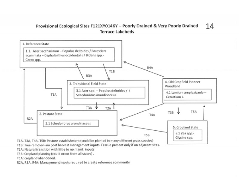
State 1. (Reference), Phase 1.1:
Acer saccharinum- Populus deltoides /Forestiera acuminata- Cephalanthus occidentalis /Bidens spp. – Carex spp.
(Silver maple – cottonwood / eastern swamp privet – buttonbush / beggartick – sedges)
These locations are characterized by poorly drained and very poorly drained soils. Most of these sites in MLRA 121 are tiled or drained and utilized as cropland, pasture, urban, or low-quality successional woodlands; therefore, the exact characteristics of a true historic reference community is difficult to accurately define.
State: 2. Pasture
State 2, Phase 2.1: Managed Pasture. Plant species dominants: Schedonorus arundinaceus (tall fescue)
State: 3 – Transitional (Abandoned) Field
State 3, Phases 3.1: Acer spp. - Populus deltoides / /Schedonorus arundinaceus
Narrative: Tree species regeneration on these sites will depend on the severity and duration of disturbance, soil characteristics, adjacent plant communities and seed sources, post-disturbance management inputs, presence or absence of continued site disturbances (grazing), slope, and aspect. Silver maple, red maple, cottonwood, and sycamore seedlings would likely be common on many wet sites.
State: 4. Old Cropfield Pioneer Woodland
State 4, Phase 4.1: Plant species dominants: henbit deadnettle (Lamium amplexicaule)- mouse-eared chickweed (Cerastium L.)
State: 5. Cropland
Phase 5.1: Plant species dominants: Zea spp. – Glycine spp.
Plants on these sites will be dependent upon seeding and management. Most common crops are corn and soybeans. Due to the drainage issues on these soil, many have been tiled extensively to facilitate crop production.
Associated sites
| F121XY015KY |
Somewhat Poorly Drained Terrace Lakebeds Somewhat Poorly Drained Terrace lakebeds |
|---|
Similar sites
| F121XY030KY |
Poorly Drained & Very Poorly Drained Floodplain Poorly drained and Very Poorly Drained Floodplains |
|---|
Table 1. Dominant plant species
| Tree |
(1) Acer saccharinum |
|---|---|
| Shrub |
(1) Forestiera acuminata |
| Herbaceous |
(1) Bidens |
Click on box and path labels to scroll to the respective text.
