Natural Resources
Conservation Service
Ecological site F122XY003KY
Deep Well Drained Loamy Uplands
Last updated: 5/14/2025
Accessed: 02/06/2026
General information
Provisional. A provisional ecological site description has undergone quality control and quality assurance review. It contains a working state and transition model and enough information to identify the ecological site.
MLRA notes
Major Land Resource Area (MLRA): 122X–Highland Rim and Pennyroyal
MLRA 122 is in Tennessee (47 percent), Kentucky (43 percent), Indiana (7 percent), and Alabama (3 percent). It makes up about 21,530 square miles (55,790 square kilometers).
SOILS:
Many of the soils in this MLRA are Udalfs. The moderately deep to very deep, well drained, clayey soils formed in limestone residuum. They are dominantly in rolling to steep areas of the “Outer Basin” (Mimosa, Braxton, Gladdice, and Hampshire series) and the undulating to hilly areas of the “Inner Basin” (Talbott and Bradyville series). The most agriculturally productive soils are the very deep, well drained, clayey or loamy soils that formed in alluvium and/or loess over alluvium or limestone residuum in nearly level to undulating areas (Armour, Cumberland, Harpeth, Lomond, and Maury series). The less extensive soils generally are moderately well drained to somewhat poorly drained and formed in loamy or clayey alluvium and/or residuum (Byler, Capshaw, Colbert, and Tupelo series). This MLRA has a significant acreage of Mollisols. Shallow or moderately deep, well drained, clayey Udolls (Ashwood and Barfield series) formed in limestone residuum dominantly in rolling to steep areas. Very shallow, well drained, clayey Rendolls (Gladeville series) formed in limestone residuum dominantly in undulating to rolling areas of the “Inner Basin.” Very deep, well drained or moderately well drained Udolls (Arrington, Egam, Lynnville, and Staser series) and somewhat poorly drained or poorly drained Aquolls (Agee, Godwin, and Lanton series) formed in loamy or clayey alluvium derived from limestone on flood plains. Most of the remaining soils on flood plains are moderately well drained or well drained Udepts (Lindell and Ocana series). Udults are of small extent in this area. Most are very deep, well drained, and loamy and formed in gravelly colluvium or colluvium and the underlying residuum on steep hillsides (Dellrose soils). Rock outcrops are common on uplands.
BIOLOGICAL RESOURCES:
This area supports mixed oak forest vegetation. White oak, black oak, northern red oak, and some scarlet oak are the dominant tree species. Shagbark hickory, bitternut hickory, pignut hickory, and mockernut hickory also occur. Oak, blackgum, flowering dogwood, sassafras, Virginia pine, pitch pine, and shortleaf pine grow mostly on ridgetops.
(Excerpt from United States Department of Agriculture, Natural Resources Conservation Service. 2006. Land Resource Regions and Major Land Resource Areas of the United States, the Caribbean, and the Pacific Basin. U.S. Department of Agriculture Handbook 296.)
Classification relationships
Scientific Name: Southern Interior Low Plateau Dry-Mesic Oak Forest, Unique Identifier: CES202.898
Possible Association:
Quercus velutina - Quercus alba - Carya(glabra, ovate) Forest
Unique Identifier: CEGL002076
Classification Approach: International Vegetation Classification (IVC)
Ecological site concept
Deep Well Drained Loamy Uplands
Initial Soil Series: Allegheny, Carpenter, Frankstown, Riney, Sonora
Communities described in this provisional document reflect plant communities that are likely to be found on these soils and have not been field verified. This PES also does not encompass the entire complexity or diversity of these sites. Field studies would be required to develop a comprehensive and science-based native plant restoration plan for these sites.
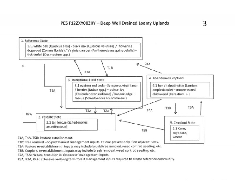
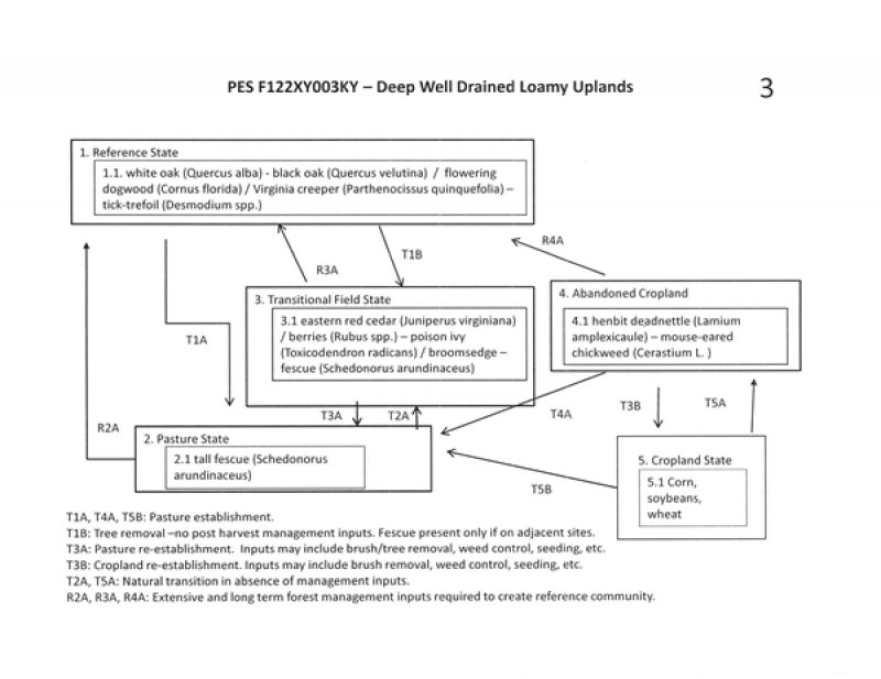
State 1. (Reference)
Phase 1.1: Plant species dominants:
Only two tree species can be selected for entry into the database as dominants; however, multiple tree species may be dominant on these sites depending on aspect, soil depth, seed sources, management, and disturbance history. Trees documented on these sites include oaks, hickories, elm, ash, maple, poplar, black walnut, dogwood, persimmon and sassafras.
black oak – white oak / flowering dogwood / Virginia creeper – ticktrefoil
(Quercus velutina – Quercus alba / Cornus florida / Parthenocissus quinquefolia - Desmodium spp.)
The absence of a natural fire regime and a history of disturbances (logging, grazing, etc.) are influences that will move this community from an old growth mixed-oak or oak-hickory community to a more mesic hardwood community. Long-term lack of a natural fire regime or human disturbances can create a more mesic, shady environment which enhances the reproduction of quick growing, fire intolerant, shade-tolerant species such as maples and reduces the successful regeneration of oaks and hickories.
The forested state may be impacted by the invasion of non-native honeysuckle within the understory.
See additional ecological states and phases under the Community Phase Data Section.
Associated sites
| F122XY001KY |
Deep Well Drained Cherty Uplands Deep, Well Drained Cherty Uplands |
|---|
Table 1. Dominant plant species
| Tree |
(1) Quercus alba |
|---|---|
| Shrub |
(1) Cornus florida |
| Herbaceous |
(1) Parthenocissus quinquefolia |
Click on box and path labels to scroll to the respective text.

