Natural Resources
Conservation Service
Ecological site F123XY005TN
Floodplains
Last updated: 5/13/2025
Accessed: 02/08/2026
General information
Provisional. A provisional ecological site description has undergone quality control and quality assurance review. It contains a working state and transition model and enough information to identify the ecological site.
MLRA notes
Major Land Resource Area (MLRA): 123X–Nashville Basin
123—Nashville Basin
This area is entirely in Tennessee (fig. 123-1). It makes up about 5,625 square miles (14,580 square kilometers). The cities of Nashville, Franklin, Hendersonville, Columbia, Murfreesboro, and Shelbyville are in this area.
Physiography
Most of this area is in the Nashville Basin Section of the Interior Low Plateaus Province of the Interior Plains. A small part of the northeast corner and the western and southern fourth of the area are in the Highland Rim Section of the same province and division. Most of the outer part of the Nashville Basin is deeply dissected and consists of steep slopes between narrow, rolling ridgetops and narrow valleys. The inner part of the basin is dominantly undulating and rolling. In many areas the land surface is deeply pitted by limestone sinks, and outcrops of limestone are almost everywhere. Elevation generally is about 650 feet (200 meters), but it is 1,000 to 1,325 feet (305 to 405 meters) on isolated hills and is as low as 450 feet (135 meters) in some of the more deeply cut stream channels.
Geology
The bedrock geology in this area consists of Ordovician limestone exposed by geologic erosion of the top of the Nashville Dome (a high part of the Cincinnati Arch) throughout this area. Sinkholes are common in the limestone and are either open to the subsurface or are covered by soils and colluvium that have collected in the depressions formed on the land surface above the sinkhole. Younger rocks occur as a rim just outside this area. Surficial deposits include loess on the less eroded landforms and alluvium along the rivers and streams.
Source: United States Department of Agriculture, Natural Resources Conservation Service. 2006. Land Resource Regions and Major Land Resource Areas of the United States, the
Caribbean, and the Pacific Basin. U.S. Department of Agriculture Handbook 296.
Classification relationships
Scientific Name: South-Central Interior Large Floodplain. Unique Identifier: CES202.705
Scientific Name: South-Central Interior Small Stream and Riparian
Unique Identifier: CES202.706
Ecological site concept
This PES grouping is in the thermic temperature regime. Soils are alluvium and on or near floodplains in MLRA 123 in central Tennessee. Historic vegetation was a variety of water tolerant hardwood tree species.
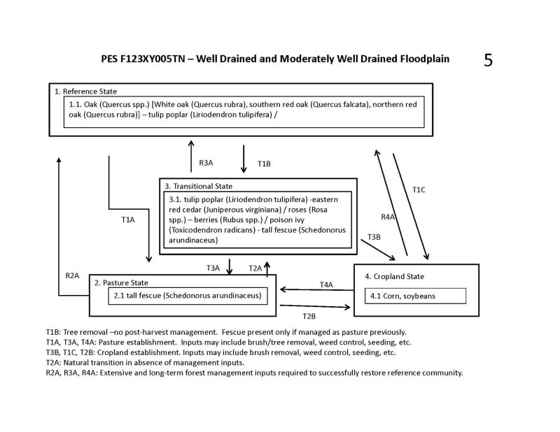
Most of these sites have historically been disturbed either through logging, grazing, other agricultural practices or development. Currently a large portion of these soils are used as croplands. The native vegetation is a mixed hardwood forest of oaks, tulip poplar, birch, sycamore, beech, elm, hickory, and maples. Species vary depending on flooding regime, available soil moisture, past disturbance severity, ongoing disturbances, and other soil properties. On soils with poorer drainage, the natural vegetation would be water tolerant oaks, sweet gum, willows, cottonwood, elm, ash, alder and maples.
Many areas are highly disturbed by decades of agricultural practices and urban development. Natural hydrology on many sites have been altered through ditching or tiling greatly altering the vegetation of present sites.
Future ESD development will result in further refinement of this group into multiple ESDs based on soil characteristics and flooding regimes.
Associated sites
| F123XY004TN |
Deep Loamy Terraces And Depressions Deep Loamy Terraces and Depressions |
|---|
Table 1. Dominant plant species
| Tree |
(1) Quercus |
|---|---|
| Shrub |
(1) Asimina triloba |
| Herbaceous |
(1) Boehmeria cylindrica |
Click on box and path labels to scroll to the respective text.
