Natural Resources
Conservation Service
Ecological site F124XY002OH
Acid Mixed Sedimentary Upland
Last updated: 9/26/2024
Accessed: 04/10/2026
General information
Provisional. A provisional ecological site description has undergone quality control and quality assurance review. It contains a working state and transition model and enough information to identify the ecological site.
MLRA notes
Major Land Resource Area (MLRA): 124X–Western Allegheny Plateau
Major Land Resource Area (MLRA): 124—Western Allegheny Plateau (USDA-NRCS, 2006)
MLRA 124, Western Allegheny Plateau extends from and includes western PA just north of Pittsburgh through southeastern OH to and includes northeastern KY. This area is primarily in the Kanawha Section of the Appalachian Province of the Appalachian Highlands. This MLRA is on an unglaciated dissected plateau with narrow level valley floors, rolling ridgetops, and hilly to steep slopes with dendritic stream drainages. A notable exception is the broad, Teays Valley, and other glacio-fluvial and glacio-lacustrine features attributed to nearby Pleistocene glaciation. Elevation ranges from 660 to 1310 feet (200 to 400 meters). The geology is predominantly cyclic beds of sandstone, siltstone, clay, shale and coal of Pennsylvanian age. Soils are dominated by Udalfs, Udults, and Ochcrepts with a mesic temperature regime in combination with five parent materials, residuum, colluvium, alluvium, eolian, and extra-glacial material of glacio-fluvial and glaciolacustrine mesic materials. The climate is predominately a humid continental to temperate, with 940 to 1145 millimeters (37 to 45 inches) of precipitation. Average annual temperature is 8 to 13 degree C (46 to 56 degrees F) with a freeze-free period averaging 185 days. Much of the areas is either forest or in farms, principally for hay and pasture, with fruits and vegetables grown locally. Coal and gas extraction are important industries in the northern part of the MLRA.
Classification relationships
USDA-NRCS (USDA 2006):
Land Resource Region (LRR): N—East and Central Farming and Forest Region
Major Land Resource Area (MLRA): 124—Western Allegheny Plateau
USDA-FS (Cleland et al. 2007):
Province: 221 - Eastern Broadleaf Province
Section: 221E - Southern Unglaciated Allegheny Plateau
Subsection: 221Ea - Pittsburgh Low Plateau
221Eb - Teays Plateau
221Ee - Unglaciated Muskingam Plains
221Ef - Western Hocking Plateau
221Eg - Lower Scotio River Plateau
221En - Kinniconick and Licking Knobs
Section: 221H - North Cumberland Plateau (in Part)
Subsection: 221Hb - Kinniconick and Licking Knobs
221He - Miami - Scioto Plain - Tipton Till Plain
Ecological site concept
Within the dissected plateau of the unglaciated Western Allegheny Plateau, the Acid Mixed Sedimentary Uplands ecological site is set in upland landscapes of high to rolling hills occupying summits, shoulders and convex slopes. The ecological site is derived from non-calcareous to acid mixed sedimentary geology primarily composed of sandstone, shale, siltstone, and coal. Most sites are well-drained to somewhat excessively-drained. Representative soils include: Aaron, Alticrest, Berks, Blairton, Bratton, Brownsville, Cavode, Clymer, Cookport, Coshocton, Cranston, Cruze, Culleoka, Dekalb, Ernest, Germano, Gilpin, Guernsey, Hazleton, Latham, Library variant, Lily, Marrowbone, Matewan, Muse, Muskingum, Opequon, Rarden, Rayne, Richland, Rigley, Schaffenaker, Shelocta, Steinsburg, Tilsit, Trappist, Upshur, Wernock, Westmoreland, Wharton. Reference plant communities include: Appalachian Chestnut Oak - Mixed Oak Forest, and White Oak - Red Oak Dry-Mesic Acidic Forest.
Associated sites
| F124XY001OH |
Shallow Acid Mixed Sedimentary Upland Shallow Acid Mixed Sedimentary Upland ecological site is often adjacent to Acid Mixed Sedimentary Upland. |
|---|---|
| F124XY004OH |
Acid Mixed Sedimentary Toeslope Acid Mixed Sedimentary Toeslope ecological site often shares in the topgraphic sequence of the same local landscape. |
Table 1. Dominant plant species
| Tree |
(1) Quercus montana |
|---|---|
| Shrub |
(1) Viburnum acerifolium |
| Herbaceous |
(1) Symphyotrichum cordifolium |
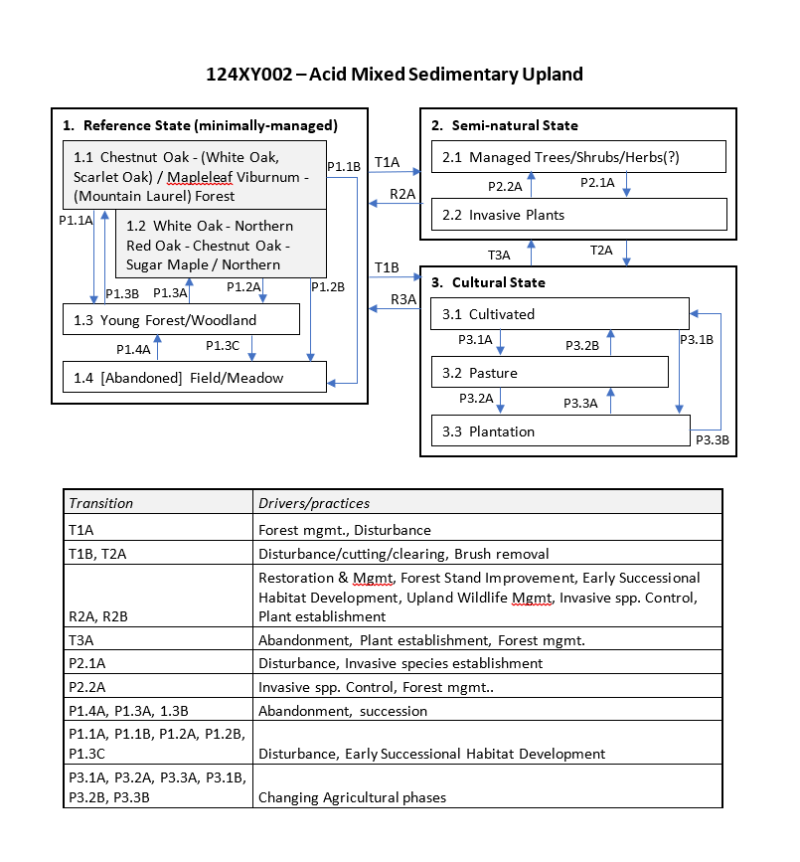
Click on box and path labels to scroll to the respective text.