Natural Resources
Conservation Service
Ecological site F126XY001OH
Dry Ridge
Last updated: 9/27/2024
Accessed: 04/10/2025
General information
Provisional. A provisional ecological site description has undergone quality control and quality assurance review. It contains a working state and transition model and enough information to identify the ecological site.
MLRA notes
Major Land Resource Area (MLRA): 126X–Central Allegheny Plateau
This ecosite is found in Alleghany plateau in MLRA 126. Steep slopes are dominant, but level to gently rolling plateau remnants exist. The area is dominantly forest, containing large blocks of state forest, game lands, and national forest. Less than one-tenth of the MLRA consists of urban areas. These sites occur on summits and are well drained.
Classification relationships
USDA-NRCS (USDA 2006):
Land Resource Region (LRR): N—East and Central Farming and Forest Region
Major Land Resource Area (MLRA): 126—Central Allegheny Plateau
USDA-FS (Cleland et al. 2007)
Province: 221 - Eastern Broadleaf Province
Section: 221E - Southern Unglaciated Allegheny Plateau
Subsection: 221Ea - Pittsburgh Low Plateau
221Eb - Teays Plateau
221Ec - Ohio Valley Lowland
221Ed - East Hocking Plateau
This site crosswalks to Landfire biophysical setting (BpS) Allegheny-Cumberland Dry Oak Forest and Woodland.
See also NatureServe’s description (2007):
Allegheny-Cumberland Dry Oak Forest and Woodland CES202.359
Component Associations
Association Unique ID Association Name
CEGL004761 Pinus echinata - Quercus prinus - Quercus (coccinea, velutina) Forest
CEGL004786 Quercus prinus - Carya (alba, glabra, ovata) / Juniperus virginiana var. virginiana Forest
CEGL005023 Quercus prinus - Quercus (alba, coccinea, velutina) / Viburnum acerifolium - (Kalmia latifolia) Forest
CEGL006557 Pinus rigida - Quercus coccinea / Vaccinium angustifolium Woodland
CEGL007119 Pinus virginiana - Pinus (rigida, echinata) - (Quercus prinus) / Vaccinium pallidum Forest
CEGL007231 Quercus alba - Quercus velutina - Carya (ovata, alba, glabra) - Pinus sp. Forest
CEGL007240 Quercus alba - Quercus rubra - Carya ovata / Cercis canadensis - Juniperus virginiana var. virginiana Forest
CEGL007244 Quercus falcata - Quercus alba - Carya alba / Oxydendrum arboreum / Vaccinium stamineum Forest
CEGL007247 Quercus falcata - Quercus (coccinea, stellata) / Vaccinium (pallidum, stamineum) Forest
CEGL007261 Quercus prinus - Carya spp. - Quercus velutina / Vaccinium arboreum / Iris verna var. smalliana Forest
CEGL007269 Quercus prinus - Quercus rubra - Carya (ovata, glabra) - Pinus virginiana Forest
CEGL007517 Pinus strobus - Quercus alba - (Carya alba) / Gaylussacia ursina Forest
CEGL007519 Pinus strobus - Quercus (coccinea, prinus) / (Gaylussacia ursina, Vaccinium stamineum) Forest
CEGL007700 Quercus prinus - Quercus spp. / Vaccinium arboreum - (Kalmia latifolia, Styrax grandifolius) Forest
CEGL007795 Quercus alba - Carya alba - (Quercus velutina) / Desmodium nudiflorum - (Carex picta) Forest
CEGL008406 Quercus stellata - Pinus virginiana / (Schizachyrium scoparium, Piptochaetium avenaceum) Woodland
CEGL008430 Quercus alba - (Quercus prinus) / (Hydrangea quercifolia) - Viburnum acerifolium / Carex picta - Piptochaetium avenaceum Forest
CEGL008431 Quercus prinus - (Quercus coccinea) / Carya pallida / Vaccinium arboreum - Vaccinium pallidum Forest
CEGL008443 Quercus alba - Quercus stellata / Ostrya virginiana - Acer barbatum / Chasmanthium sessiliflorum Forest
CEGL008521 Quercus alba - Quercus (coccinea, velutina, prinus) / Gaylussacia baccata Forest
CEGL008567 Quercus alba - Quercus falcata / Vaccinium (arboreum, hirsutum, pallidum) Forest
Ecological site concept
These sites generally occur on sumits with well drained soils and MAAT > 45 degree F.
From Landfire http://www.landfire.gov/index.php:
This ecological section comprises part of the Appalachian Plateaus geomorphic province (USDA Forest Service 1995). It is a maturely dissected plateau characterized by high hills, sharp ridges, and narrow valleys. Bedrock is overlain by Quaternary residuum on the ridges and hilltops, colluvium on the slopes, and either or both alluvium and Pleistocene lacustrine materials in the valleys. Udalfs, Udults, and Ochrepts dominate, in combination with mesic soil temperature regime, an udic soil moisture regime, and mixed or illitic mineralogy. Soils formed in parent materials are divided into five groups:residual material, which developed in place by the weathering of underlying bedrock; colluvial material which weathered from bedrock strata transported by water and gravity to the lower slopes; alluvium, lacustrine sediments and outwash deposited by water; and loess deposited by wind. Precipitation averages 35 to 45in (900 to 1,150mm0150mm); it occurs mainly during summer, winter, and spring. Rain on snow is common during winter and early spring. Summers are dry with low humidity. Temperature averages 52 degrees F (11 degrees C). The growing season is 120 to 180 days. This ecological section is characterized by a relatively high density of streams, with gradients ranging from high, steep headwaters streams to low gradient rivers that flow into the OH River.
NatureServe (2007) provides the following description pertaining to this system type. These oak-dominated forests are one of the matrix forest systems in the northeastern and north-central US Occurring in dry-mesic settings, they are typically closed-canopy forests, though there may be areas of patchy-canopy woodlands. They cover large expanses at low to mid elevations, where the topography is flat to gently rolling, occasionally steep. Soils are acidic and relatively infertile but not strongly xeric.
Associated sites
| F126XY003OH |
Moist Ridge Moist Ridge |
|---|
Table 1. Dominant plant species
| Tree |
(1) Quercus prinus |
|---|---|
| Shrub |
(1) Kalmia latifolia |
| Herbaceous |
Not specified |
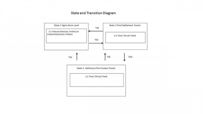
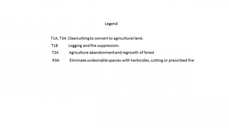
Click on box and path labels to scroll to the respective text.

