
Natural Resources
Conservation Service
Ecological site F128XY002TN
Thermic Shallow Well Drained Alfic Limestone Uplands
Accessed: 04/28/2025
General information
Approved. An approved ecological site description has undergone quality control and quality assurance review. It contains a working state and transition model, enough information to identify the ecological site, and full documentation for all ecosystem states contained in the state and transition model.
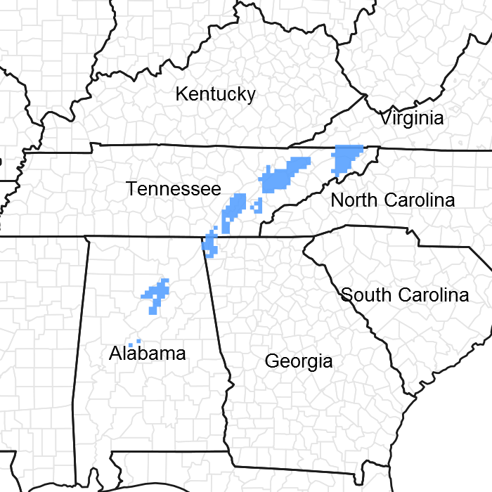
Figure 1. Mapped extent
Areas shown in blue indicate the maximum mapped extent of this ecological site. Other ecological sites likely occur within the highlighted areas. It is also possible for this ecological site to occur outside of highlighted areas if detailed soil survey has not been completed or recently updated.
MLRA notes
Major Land Resource Area (MLRA): 128X–Southern Appalachian Ridges and Valleys
MLRA 128, partially shown as the gray shaded area on the accompanying figure, falls into the East and Central Farming and Forest Region. This MLRA is in Tennessee (36 percent), Alabama (27 percent), Virginia (25 percent), and Georgia (12 percent). It makes up about 21,095 square miles (54,660 square kilometers).
Most of this MLRA is in the Tennessee Section of the Valley and Ridge Province of the Appalachian Highlands. The thin stringers in the western part of the area are mostly in the Cumberland Plateau Section of the Appalachian Plateaus Province of the Appalachian Highlands. A separate area of the MLRA in northern Alabama is in the Highland Rim Section of the Interior Low Plateaus Province of the Interior Plains. The western side of the area is dominantly hilly to very steep and is rougher and much steeper than the eastern side, much of which is rolling and hilly. Elevation ranges from 660 feet (200 meters) near the southern end of the area to more than 2,400 feet (730 meters) in the part of the area in the western tip of Virginia. Some isolated linear mountain ridges rise to nearly 4,920 feet (1,500 meters) above sea level.
The MLRA is highly diversified. It has many parallel ridges, narrow intervening valleys, and large areas of low, irregular hills. The bedrock in this area consists of alternating beds of limestone, dolomite, shale, and sandstone of early Paleozoic age. Ridgetops are capped with more resistant carbonate and sandstone layers, and valleys have been eroded into the less resistant shale beds. These folded and faulted layers are at the southernmost extent of the Appalachian Mountains. The narrow river valleys are filled with unconsolidated deposits of clay, silt, sand, and gravel.
Classification relationships
This ESD is within NRCS Major Land Resource Area (MLRA) 128 - Southern Appalachian Ridges and Valleys. It falls within the Environmental Protection Agency's "Southern Limestone/Dolomite Valleys and Low Rolling Hills" ecoregional classification (Authors: Glenn Griffith, James Omernik, Sandra Azevedo). Most of this site is covered by the "Central Ridge and Valley, Rolling Limestone Hills" Subsection of the U.S. Forest Service's Ecological Units of the Eastern United States (Authors: J.E. Keys, Jr., C. Carpenter, S. Hooks, F. Koenig, W.H. McNab, W. Russell and M.L. Smith). Additionally, the USGS National Gap Analysis Program and Natureserve classifies the vegetation on this site under multiple communities including: Southern Ridge and Valley/Cumberland Dry Calcareous Forest, Central Appalachian Pine-Oak Rocky Woodland and South-Central Interior Mesophytic Forest, among others. Natureserve describes the glade component of the ecological site under the Southern Ridge and Valley Calcareous Glade and Woodland classification (Natureserve 2014).
Ecological site concept
The Thermic Well Drained Alfic Limestone Upland ecological site is of small extent in this MLRA, primarily occurring in Tennessee but with small acreages in Alabama and Georgia. Part of this ecological site falls outside MLRA 128, in MLRA 129. Vegetation communities on this site occur as a mosaic and can include forests, woodlands and glades. The potential natural vegetation (reference state) can vary depending largely on the depth of the soil at very small scales, often determined by the strike of limestone bedrock. This localized variability cannot be captured at the scale of Order 2 soils mapping. In addition, vegetation communities shift temporally due to localized erosion and weather conditions.
This site is characterized by nearly level to extremely steep upland slopes with gradients ranging from 0 to 70 percent. Some areas have Karst topography. Most of this ecological site has been cleared of natural vegetation. About 70 percent of the cleared areas are in pasture and hay. Crops are not typically an important part of this site. Many areas are idle.
Threatened calcareous habitats occur within this ecological site, including xeric limestone prairies, limestone glades and barrens (naming follows Lawless, Baskin and Baskin, 2006). These communities are a conservation priority due to relatively high taxonomic richness and associated occurrence of rare and endemic plant species.
Table 1. Dominant plant species
| Tree |
(1) Quercus muehlenbergii |
|---|---|
| Shrub |
(1) Cercis canadensis |
| Herbaceous |
(1) Pleopeltis polypodioides |
Physiographic features
This ecological site occurs on nearly level to extremely steep uplands weathered from limestone and extremely steep ridge tops, shoulder slopes, and side slopes derived from interbedded limestone and shale or weathered calcareous siltstone, shale or mudstone. Slopes range from 0 - 70%. Elevation ranges from 800 to 1400 feet. Some areas have karst topography. Soils in this ecological site are often associated with bedrock outcrops.
This site can generate medium and high runoff to adjacent ecological sites. This site does not flood.
Table 2. Representative physiographic features
| Landforms |
(1)
Ridge
(2) Hill (3) Valley |
|---|---|
| Flooding frequency | None |
| Ponding frequency | None |
| Elevation | 244 – 427 m |
| Slope | 0 – 70% |
Climatic features
This area falls under the humid, mesothermal climate classification (Thornwaite 1948). Precipitation is fairly evenly distributed throughout the year, with little or no water deficiency during any season. The average annual precipitation in most of this area is 45 – 55 inches. It increases to the south. Maximum precipitation occurs in midwinter and midsummer, and the minimum occurs in autumn. Most rainfall occurs as high-intensity, convective thunderstorms. Snowfall may occur in winter.
Average annual temperatures range from 46 - 70 degrees F, increasing to the south. The freeze-free period averages 205 days and is longest in the southern part of the area and shortest at higher elevations to the north. The growing season corresponds. Local climate can be variable and microclimates factor into the distribution of plants. In general, topographic features such as slope aspect, landform, steepness and position of the ridges and valleys are important site variables in the distribution of vegetation across the landscape (Martin, 1989).
Table 3. Representative climatic features
| Frost-free period (average) | 195 days |
|---|---|
| Freeze-free period (average) | 172 days |
| Precipitation total (average) | 1,346 mm |
Figure 2. Monthly precipitation range
Figure 3. Monthly average minimum and maximum temperature
Figure 4. Annual precipitation pattern
Figure 5. Annual average temperature pattern
Influencing water features
This site is not influenced by water from a wetland or stream.
Soil features
This ecological site is represented by soils in the Mollisols and Alfisols soil orders. Major soil series for this ecological site are Barfield, Loyston, and Gladeville.
The Barfield and Gladeville soils are found on gently sloping to steep uplands on tilted, thinly bedded limestone bedrock.
Loyston also occurs on gently sloping to steep uplands and overlies tilted, interbedded shale and limestone or calcareous siltstone, shale or mudstone.
Map units having these soils as both major and minor components, either in consociations or complexes, make up the majority of the ecological site. Soil complexes often include a rock outcrop component. These soils have a thermic temperature regime and an udic moisture regime.
Soil map units named "rockland" are not included in this ecological site. They are present in counties with old surveys and will be addressed in future update projects to assess what their appropriate ecological site will be.
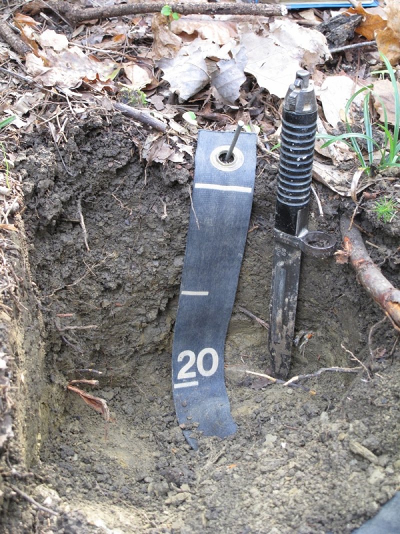
Figure 6. Loyston Soil Series
Table 4. Representative soil features
| Parent material |
(1)
Residuum
–
limestone
|
|---|---|
| Surface texture |
(1) Gravelly silt loam (2) Channery silty clay loam (3) Clay |
| Drainage class | Well drained to excessively drained |
| Permeability class | Moderately slow to moderate |
| Soil depth | 0 – 130 cm |
| Surface fragment cover <=3" | 0 – 40% |
| Surface fragment cover >3" | 2 – 15% |
| Calcium carbonate equivalent (0-101.6cm) |
0% |
| Electrical conductivity (0-101.6cm) |
0 mmhos/cm |
| Sodium adsorption ratio (0-101.6cm) |
0 |
| Soil reaction (1:1 water) (0-101.6cm) |
5.6 – 7.8 |
Ecological dynamics
The information contained in the State and Transition Model (STM) and the Ecological Site Description was developed using archeological and historical data, professional experience, and scientific studies. The information presented is representative of a very complex set of plant communities. Not all scenarios or plants are included. Key indicator plants, animals and ecological processes are described to inform land management decisions.
The historic reference plant community phase of this site was probably a mosaic of forests, woodlands and glades. The vegetation type varies across the extent of the MLRA and is influenced by the strike of limestone bedrock, human and natural disturbances and edaphic conditions over time. Species composition is affected by aspect, slope position and soil depth.
This site contains limestone glade ecosystems that occur at scales too small to map. However, these are extremely important ecosystems as they can contain a high number of rare plants and provide habitat for unique animal communities. Glades are naturally persistent due to the harsh edaphic conditions locally present where bedrock outcrops occur and where soils are extremely shallow. Glades are frequently disrupted by frost upheavals, which aids in their persistence. Dry conditions prevail throughout most of the growing season, but the ground may be saturated in spring, winter and fall. Where soils become slightly deeper, woodland tree encroachment begins. As bedrock dissolves and depressions form, soil also forms and becomes deeper. As this occurs, plant communities change and add to the soil so this ecological site is in constant temporal flux. During dry, hot years glades can reappear in places where they had been lost to woodland. Geology strike appears to be extremely important to the occurrence of glades and especially to the size and extent of glades in the Ridge and Valley. In the Tennessee portion of the Ridge and Valley, strike is sharper and so glades are of much smaller extent. Also, glades have a harder time persisting without management because of increased pressure from surrounding woodlands.
Fire frequencies in these systems are poorly understood, as not much research has been conducted to date. However, fire undoubtedly did have some influence, although it is probably not needed on a frequent basis (Schotz, 2014). Any management recommendations involving fire need to be site based and will probably require adjustment over time, as data are collected on plant community responses to that disturbance.
Much of this ecological site is currently being grazed or has been grazed in the past. Depending on the extent of the disturbance, invasive, exotic plants can become problematic.
Recovery times on degraded glades and glade-woodlands within this site appear to be dictated by a combination of the degree to which the original vegetation cover has been altered and the dryness of the site (Schotz, 2014). For example, on the dry calcareous forest component of the reference state, sites with seed trees present such as oaks, ash, and hickory, will likely have less recovery time than sites where all seed trees have been logged out.
In order to depict the variability in vegetation communities on this site, the reference state in the State and Transition diagram has been modified to show both the forested and more open glade components separately. Data tables will reflect some of the differences in species composition, canopy coverage, etc.
State and transition model
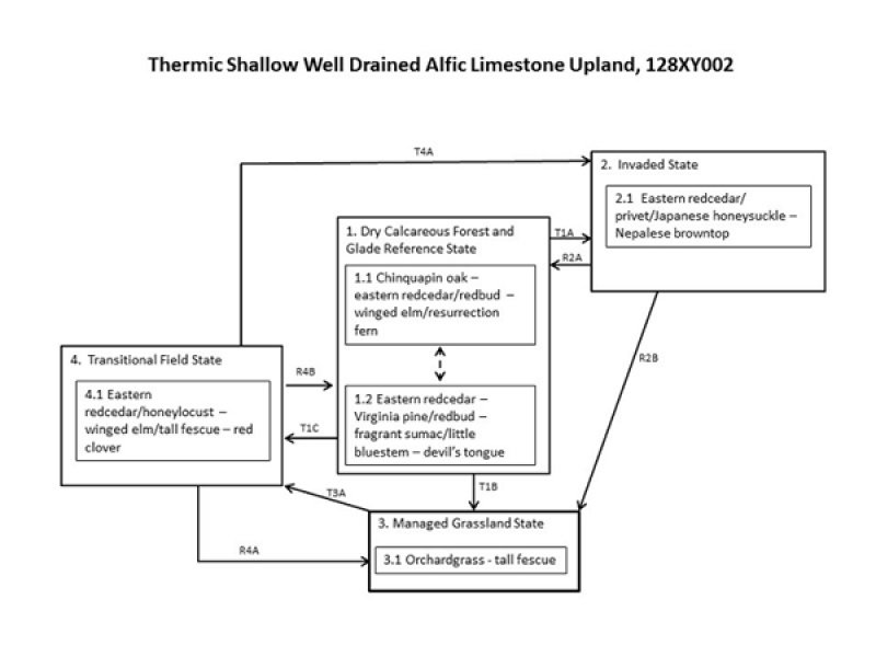
Figure 7. State and Transition Diagram

Figure 8. Legend
More interactive model formats are also available.
View Interactive Models
More interactive model formats are also available.
View Interactive Models
Click on state and transition labels to scroll to the respective text
State 2 submodel, plant communities
State 3 submodel, plant communities
State 4 submodel, plant communities
State 1
Dry Calcareous Forest and Glade Reference State
The reference community for this ecological state occurs as a mosaic of dry forests, woodlands and small glades across the landscape. Past disturbance, both human caused and naturally occurring, can influence the degree of openness and thereby the distribution of species. In addition, the strike of limestone bedrock often determines where true glades versus forests occur. Where strike is sharp, solution pipes form and deeper soils accumulate, favoring tree growth. Where bedrock is more level, with shallow soils forming, glades and woodlands tend to occur. This is highly variable across the Major Land Resource Area and species can shift temporally due to edaphic conditions from year to year. For example, in periods of drought, forest species retreat, which creates the open conditions that favor grasses and herbs.
Community 1.1
Chinquapin oak – eastern redcedar/redbud – winged elm/resurrection fern
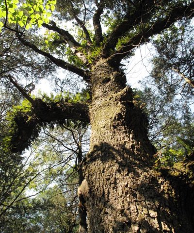
Figure 9. Chinquapin oak covered in resurrection fern

Figure 10. Resurrection fern
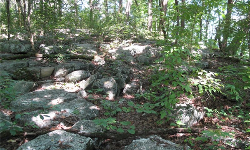
Figure 11. Calcareous forest 1
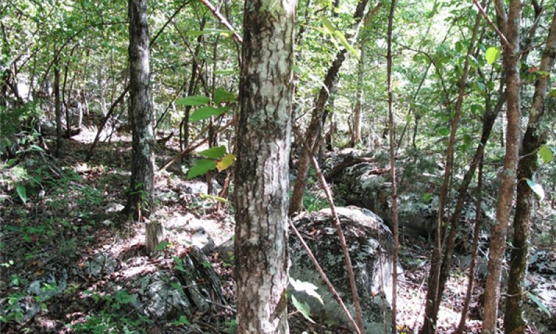
Figure 12. Calcareous forest 2
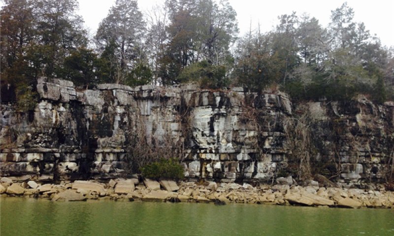
Figure 13. Bedrock geology under Barfield soil series
This phase of the reference state occurs over soils derived from limestone that typically have a neutral pH and relatively dry conditions. Forests are dominated by calciphiles, including chinquapin oak, Shumard oak, white ash, eastern red cedar, eastern redbud, and many elms and hickories. Shrubs and small trees include fragrant sumac, rusty blackhaw, dwarf hackberry, and Carolina buckthorn. Plant composition will vary according to the pH and level of moisture in the soil as well as soil depth. These forests typically occur as part of a vegetation mosaic with cedar glades on more level limestone. They can also occur on limestone outcrop at the base of other geologic formations, such as the Rome formation. In Georgia, these communities occur on the lower slopes of the eastern side of Lookout Mountain and Pigeon Mountain and on parts of Lavender Mountain at Berry College (Edwards, Ambrose and Kirkman 2013). The neutral pH and resulting pattern of calciphytic plants are the main factors that differentiate this ecological site from others. Without disturbance, such as fire, these forests will succeed from oak dominated canopies to more shade tolerant species such as red maple, sugar maple and American beech (Edwards, Ambrose and Kirkman 2013). The presence of oak and pine possibly reflects past disturbances that opened canopies up enough to facilitate their establishment. Gaps were likely an important component of forest dynamics, especially on steeper bluffs or through openings created by fire (W.L. Lipps 1966; Wharton 1978; Pyne 1982; Schuler and McClain 2003 in Edwards, Ambrose and Kirkman 2013). The variation in the composition of this plant community complicates fire management. Currently, the Georgia Department of Natural Resources recommends fire-return intervals of five - seven years for some plant communities on this ecological site. However, any fire management plan should be developed with professionals on site, based on local conditions. Fires can foster high herbaceous diversity in these communities but can also damage fire-intolerant trees and shrubs that can be important features of the natural system (Edwards, Ambrose and Kirkman 2013).
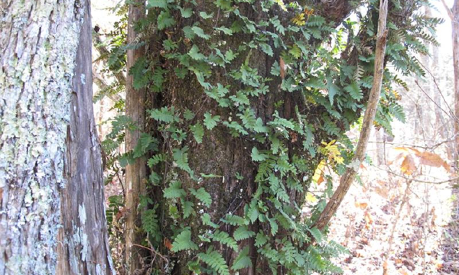
Forest overstory. The forests occurring on this phase of the ecological site are closed canopy stands distinguished by calcium-loving species in all strata (Edwards, Ambrose and Kirkman 2013). Important overstory trees include chinquapin oak, Shumard oak, white oak, eastern red cedar and numerous hickory species. The ones most commonly noted were shagbark and mockernut hickory. Ashes, especially white ash, are important on this site, as well as slippery elm, winged elm, and the hawthorns. Vines and ferns can be important in this community phase and a common sight is a chinquapin oak or eastern red cedar covered in resurrection fern (pictured above).
Forest understory. Forest understories in this phase tend to be sparse, due to the closed canopy. However, because it favors calciphiles, species composition can be quite different from other ecological sites in the Ridge and Valley. Resurrection fern and purple cliffbrake are common. Typical herbs include Indian pink, hoary puccoon, smallhead blazing star, wild petunia, and trailing lespedeza. Tree and shrub regeneration is well represented in the understory with white ash and sugar maple predominating. Vines can be important, perhaps reflecting past disturbance. Common vines include crossvine, trumpet creeper, common moonseed, and greenbrier. Mosses and lichens can be important components of this site and commonly grow on bedrock outcrops. Depending on the percent of canopy cover, grasses may occur on this phase. Some of the native panic grasses and purpletop tridens are common and can be prolific in places.
Table 5. Soil surface cover
| Tree basal cover | 5-8% |
|---|---|
| Shrub/vine/liana basal cover | 1-3% |
| Grass/grasslike basal cover | 1-10% |
| Forb basal cover | 1-5% |
| Non-vascular plants | 0-3% |
| Biological crusts | 0-15% |
| Litter | 30-80% |
| Surface fragments >0.25" and <=3" | 0-7% |
| Surface fragments >3" | 2-10% |
| Bedrock | 15-47% |
| Water | 0% |
| Bare ground | 0-3% |
Table 6. Woody ground cover
| Downed wood, fine-small (<0.40" diameter; 1-hour fuels) | 5-20% |
|---|---|
| Downed wood, fine-medium (0.40-0.99" diameter; 10-hour fuels) | 5-20% |
| Downed wood, fine-large (1.00-2.99" diameter; 100-hour fuels) | 5-10% |
| Downed wood, coarse-small (3.00-8.99" diameter; 1,000-hour fuels) | 5-10% |
| Downed wood, coarse-large (>9.00" diameter; 10,000-hour fuels) | 0-10% |
| Tree snags** (hard***) | – |
| Tree snags** (soft***) | – |
| Tree snag count** (hard***) | |
| Tree snag count** (hard***) |
* Decomposition Classes: N - no or little integration with the soil surface; I - partial to nearly full integration with the soil surface.
** >10.16cm diameter at 1.3716m above ground and >1.8288m height--if less diameter OR height use applicable down wood type; for pinyon and juniper, use 0.3048m above ground.
*** Hard - tree is dead with most or all of bark intact; Soft - most of bark has sloughed off.
Table 7. Canopy structure (% cover)
| Height Above Ground (m) | Tree | Shrub/Vine | Grass/ Grasslike |
Forb |
|---|---|---|---|---|
| <0.15 | – | 1-1% | 1-2% | 0-1% |
| >0.15 <= 0.3 | – | 1-2% | 1-2% | 1-3% |
| >0.3 <= 0.6 | – | 1-5% | 1-1% | 1-1% |
| >0.6 <= 1.4 | – | 1-10% | – | – |
| >1.4 <= 4 | – | 2-20% | – | – |
| >4 <= 12 | 5-25% | – | – | – |
| >12 <= 24 | 25-60% | – | – | – |
| >24 <= 37 | 0-5% | – | – | – |
| >37 | – | – | – | – |
Community 1.2
Eastern redcedar – Virginia pine/redbud - fragrant sumac/little bluestem – devil's-tongue
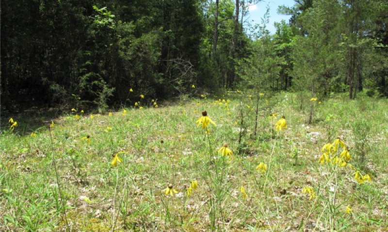
Figure 14. Cedar glade in June
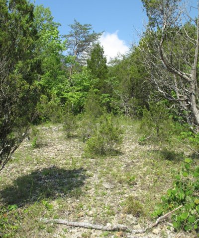
Figure 15. Gravelly surface fragments
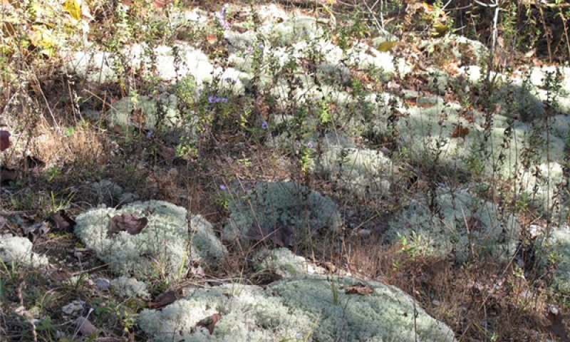
Figure 16. Moss and asters in November
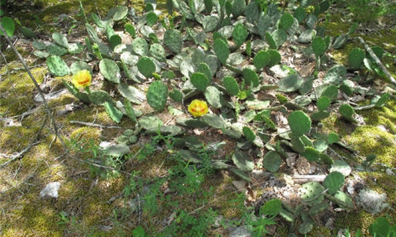
Figure 17. Opuntia humifusa blooming in late May
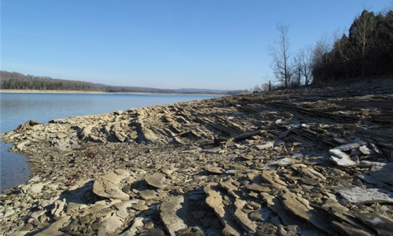
Figure 18. Limestone parent material in winter
The natural forest openings that correspond to glade communities on this ecological site are chiefly scattered in areas underlain by limestone of the Chickamauga group, especially Lenoir limestone (Martin 1989). Stunted cedar and pine and a few shrub species surround an herb-dominated outcrop. Wherever joints in the rock have accumulated soil, woody plants will establish. Climate conditions vary from year to year. Woody plants, especially cedar trees, will do better in years with more precipitation and fall back in hot, dry periods. Vegetation is similar to the cedar glades of middle Tennessee, but pine is a significant component (Martin 1989). This phase may be considered distinct from other prairie-like areas in that it is chiefly edaphic in nature. The bare rock and shallow soils create moisture and temperature extremes that fluctuate from year to year and season to season, restricting these sites to plant species that have adapted to heat and drought (Edwards, Ambrose and Kirkman 2013). Precipitation differences cause these sites to have radically different appearances from year to year. Correspondingly, these sites can change greatly in appearance with the season. In spring, open glades might be carpeted with wildflowers but when the annuals die, xerophytes such as devil's tongue, false aloe and croton become more conspicuous (Edwards, Ambrose and Kirkman 2013). Erosion, drought, fire, grazing, frost-heave and shrink-swell soils can all contribute to keeping these systems open (Edwards, Ambrose and Kirkman 2013). The role of fire is not well understood from a management perspective. However, in Georgia, a fire-return interval of 13 - 25 years has been suggested (Frost 1998; NatureServe Ecology South 2008; in Edwards, Ambrose and Kirkman 2013).
Forest overstory. There are very few forest canopy trees in this phase of the reference state but, when present, common species include Virginia pine and eastern red cedar. Occasionally oak species occur, such as chinquapin oak and shumard oak. Trees in this phase are often shrubby and rarely reach their height potential. Shrub and small tree species include redbud, winged elm, persimmon, fragrant sumac and dogwood.
Forest understory. The Natural Communities of Georgia (2013) divides the vegetation into four categories: gravel glades, grassy glades, shrub thickets and glade woodlands, which are all driven by soil depth at very small scales. Understory composition can vary widely, depending on the location within the site. On gravel glades where there is very little soil, lichens, mosses and least glade cress will dominate. In areas with slightly deeper soils, the gravel glades can support other herbs, typically annuals. Grasses can dominate on sites where there is deeper soil, but not deep enough to support shrubs and small trees. Little bluestem is a typical species noted on these areas.
Some characteristic plants of this phase include hoary puccoon, false aloe, devil's tongue, the ragworts, and the goldenrods.
Table 8. Soil surface cover
| Tree basal cover | 0-8% |
|---|---|
| Shrub/vine/liana basal cover | 0-4% |
| Grass/grasslike basal cover | 0-15% |
| Forb basal cover | 0-2% |
| Non-vascular plants | 0% |
| Biological crusts | 0-1% |
| Litter | 0-10% |
| Surface fragments >0.25" and <=3" | 0-30% |
| Surface fragments >3" | 0-15% |
| Bedrock | 0-10% |
| Water | 0% |
| Bare ground | 0-5% |
Table 9. Woody ground cover
| Downed wood, fine-small (<0.40" diameter; 1-hour fuels) | 0-2% N* |
|---|---|
| Downed wood, fine-medium (0.40-0.99" diameter; 10-hour fuels) | 0-3% |
| Downed wood, fine-large (1.00-2.99" diameter; 100-hour fuels) | 0-2% |
| Downed wood, coarse-small (3.00-8.99" diameter; 1,000-hour fuels) | 0-1% |
| Downed wood, coarse-large (>9.00" diameter; 10,000-hour fuels) | 0% |
| Tree snags** (hard***) | – |
| Tree snags** (soft***) | – |
| Tree snag count** (hard***) | 0 per hectare |
| Tree snag count** (hard***) |
* Decomposition Classes: N - no or little integration with the soil surface; I - partial to nearly full integration with the soil surface.
** >10.16cm diameter at 1.3716m above ground and >1.8288m height--if less diameter OR height use applicable down wood type; for pinyon and juniper, use 0.3048m above ground.
*** Hard - tree is dead with most or all of bark intact; Soft - most of bark has sloughed off.
Table 10. Canopy structure (% cover)
| Height Above Ground (m) | Tree | Shrub/Vine | Grass/ Grasslike |
Forb |
|---|---|---|---|---|
| <0.15 | – | – | 0-1% | 0-1% |
| >0.15 <= 0.3 | – | – | 0-2% | 0-1% |
| >0.3 <= 0.6 | – | – | – | – |
| >0.6 <= 1.4 | – | – | – | – |
| >1.4 <= 4 | – | – | – | – |
| >4 <= 12 | – | – | – | – |
| >12 <= 24 | – | – | – | – |
| >24 <= 37 | – | – | – | – |
| >37 | – | – | – | – |
State 2
Invaded State
Invasive exotic plants are species of plants that have been intentionally or unintentionally introduced into an area outside of their natural range. These plants are rapidly becoming one of the most pressing management issues for land managers. Exotic species can overwhelm native plants by claiming resources such as nutrients, water, light, and space and can ultimately totally displace native species (Tennessee Exotic Pest Plant Council). By modifying or completely altering the vegetation community, exotic plants can significantly threaten native wildlife communities, including insects that act as pollinators for agriculture crops. The effects are cascading and far reaching and can be extremely detrimental to ecosystem health and stability. Invasion by exotic plants is a significant threat to this ecological site. In the glade phase of the reference state, invasion by the native eastern redcedar due to fire suppression can also be a threat. Prescribed fire and mechanical removal can be useful for creating open conditions conducive to glade plants. For clarification, this state description refers only to invasion by exotic plants. Exotic plant invasion is particularly problematic on this site for a number of reasons. Most of this site (glades and woodlands) has at one time been grazed by domestic livestock, which both introduced exotic plants into the site and created a disturbance that favored their establishment (Baskin and Baskin 1996; Cofer et al. 2008). Not all grazed sites were entirely cleared for pasture. The degree of disturbance as well as the time since abandonment will determine the extent of invasion. Secondly, the lack of natural disturbances, such as fire, have led to the expansion of invasive exotic plants due to the processes of natural succession. One of the most problematic exotic species on this site is Nepalese browntop, which is extremely tolerant of shade. As open conditions become closed forests, it spreads. Likewise, Chinese privet has invaded both glade and forested phases of this site. Both Nepalese browntop and privet inhibit the use of prescribed fire, complicating restoration efforts. Two of the protected areas that fall within this ecological site have management plans that describe their issues with exotic plant encroachment into glade/woodland systems. In one, autumn olive, sericea lespedeza, Chinese privet, Amur honeysuckle, Japanese honeysuckle, multiflora rose, crownvetch, Nepalese browntop, and Johnsongrass are listed as threats to their preserve. In another plan, Chinese privet is listed as a significant threat to the natural integrity of the site. Cofer et al. (2008) found that the exotic species Chinese privet, oxeye daisy, and common dandelion occurred on the majority of the glades in their study of 40 cedar glades in Rutherford County, Tennessee. The occurrence and abundance of exotic plant species on this ecological site will vary based on disturbance history and location. Sites adjacent to roads or disturbed areas are more likely to become invaded. Management plans should be based on local conditions and tailored to the exotic species present. In most cases, if no action is taken to combat invasions, the site will never entirely return to the reference plant community.
Community 2.1
Eastern redcedar/privet/Japanese honeysuckle – Nepalese browntop
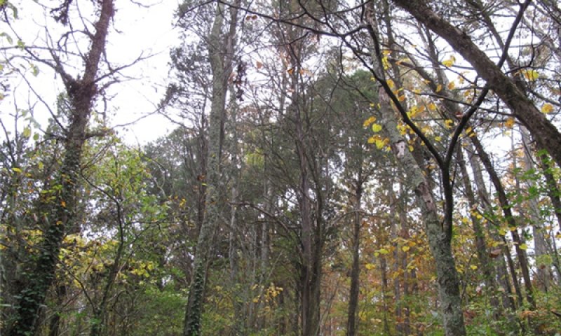
Figure 19. Invaded forest
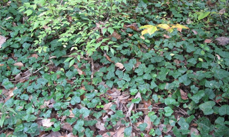
Figure 20. English ivy and Amur honeysuckle
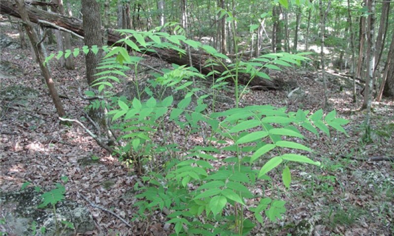
Figure 21. Tree of heaven
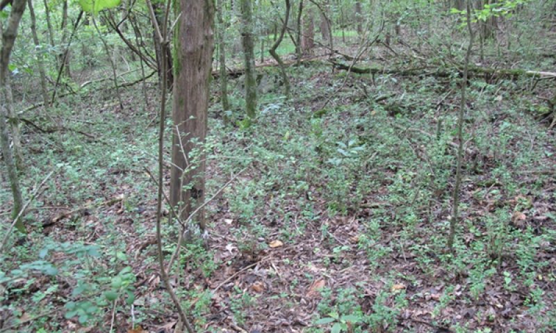
Figure 22. Exotic privet
Invasion by exotic plant species is a serious problem on this ecological site. Because of the high pH relative to other sites, and the somewhat fragile nature of plant communities, this site may be more susceptible than others in the Ridge and Valley. This site, especially where bedrock is relatively level, would have been heavily grazed in the past, adding to the potential for invasion. This site does not seem to recover as quickly from negative disturbance. Invaded states may never recover their former plant communities if management intervention is not attempted. The species listed in this phase represent a typical assemblage on an invaded state. Species composition will vary according to local conditions and past disturbance history. The species list below is a record of all species noted in the field while investigating this phase of the site. No one plot contained all listed species.
Forest overstory. Forest overstories are not typically different from the reference community, except where eastern redcedar has become dominate on glades. Typical species noted in woodlands and forests include eastern redcedar, chinquapin oak, Shumard oak, and post oak. Other oak species can occur as well as the maples and American beech, although this was not noted frequently. Often, disturbance history can be discerned to some extent by the presence of Virginia pine, which is considered a pioneer species.
Midstory species are also not different from the reference community and include eastern redbud, dwarf hackberry, dogwood, winged elm, and Carolina buckthorn. Notably, mid-story species were less common on highly invaded sites, indicating that their regeneration and establishment potential may be negatively impacted by the presence of invasive exotic plants in the understory. It can be inferred that this also applies to overstory species, given long enough timeframes. Concurrently, grazing animals utilize the mid-story and so would have impacted mid-story species on abandoned sites that were grazed woodlands.
Forest understory. Forest understories are typically highly altered, with invasive exotic species dominating and native species only present in small populations. Species assemblages are altered as well. The presence and abundance of invasive exotic species can be highly variable across the site and is most often an effect of past disturbance history and location.
Table 11. Soil surface cover
| Tree basal cover | 0-10% |
|---|---|
| Shrub/vine/liana basal cover | 0-10% |
| Grass/grasslike basal cover | 0-1% |
| Forb basal cover | 0-2% |
| Non-vascular plants | 0% |
| Biological crusts | 0-5% |
| Litter | 0-72% |
| Surface fragments >0.25" and <=3" | 0% |
| Surface fragments >3" | 0% |
| Bedrock | 0% |
| Water | 0% |
| Bare ground | 0% |
Table 12. Woody ground cover
| Downed wood, fine-small (<0.40" diameter; 1-hour fuels) | – |
|---|---|
| Downed wood, fine-medium (0.40-0.99" diameter; 10-hour fuels) | – |
| Downed wood, fine-large (1.00-2.99" diameter; 100-hour fuels) | – |
| Downed wood, coarse-small (3.00-8.99" diameter; 1,000-hour fuels) | – |
| Downed wood, coarse-large (>9.00" diameter; 10,000-hour fuels) | – |
| Tree snags** (hard***) | – |
| Tree snags** (soft***) | – |
| Tree snag count** (hard***) | 0-12 per hectare |
| Tree snag count** (hard***) | 0-5 per hectare |
* Decomposition Classes: N - no or little integration with the soil surface; I - partial to nearly full integration with the soil surface.
** >10.16cm diameter at 1.3716m above ground and >1.8288m height--if less diameter OR height use applicable down wood type; for pinyon and juniper, use 0.3048m above ground.
*** Hard - tree is dead with most or all of bark intact; Soft - most of bark has sloughed off.
Table 13. Canopy structure (% cover)
| Height Above Ground (m) | Tree | Shrub/Vine | Grass/ Grasslike |
Forb |
|---|---|---|---|---|
| <0.15 | – | 2-60% | 0-1% | 1-2% |
| >0.15 <= 0.3 | – | 0-5% | 0-1% | 1-2% |
| >0.3 <= 0.6 | – | 2-10% | – | – |
| >0.6 <= 1.4 | – | 2-20% | – | – |
| >1.4 <= 4 | – | 2-30% | – | – |
| >4 <= 12 | 5-20% | – | – | – |
| >12 <= 24 | 50-60% | – | – | – |
| >24 <= 37 | – | – | – | – |
| >37 | – | – | – | – |
State 3
Managed Grassland State
This state represents a once-forested area now cleared for pasture. The Official Soil Series description for Barfield states that about 50 percent of the original vegetation has been cleared and that most cleared areas are used for pasture. Pasture may be slightly less common on the other mapped soil series included in this site description. Limestone rock outcrop and bare ground related to rock outcrop is common on this site and is often noted in pastures. Most pastures are very old and have been established for a long time. Management practices focus primarily on maintaining healthy pasture conditions rather than new pasture establishment, although that is certainly an option. Balancing stocking rates, grazing rotation, and nutrient inputs are the primary management concerns. In general, pasture management recommendations focus on maximizing desirable forage species to outcompete undesirable or weedy species. Production practices that result in overgrazing and low fertility levels favor emergence, propagation, and growth of weeds (Green et al., 2006). Effective pasture management includes the following practices: - maintaining proper soil pH and fertility levels - using controlled grazing practices - mowing at proper timing and stage of maturity - allowing new seedlings to become well established before use, and - renovating pastures when needed (Green et al. 2006). Tennessee has developed a list of desirable species, intermediate species and undesirable species for use in a Pasture Condition Scoresheet, which can be used to develop management recommendations on a site by site basis. District Conservationists as well as the State Grazing Specialist can be consulted to assist in developing management recommendations. Perilla (Perilla frutescens) mint is an exotic, invasive weed that has become a major problem in many pastures. It causes more cattle deaths (in Tennessee) than any other toxic plant (Steckel and Rhodes, 2007). Keeping a ready supply of quality feed available for farm animals in the late summer and early fall will help to minimize the risk to livestock. Cattle will not normally feed on perilla unless there is a shortage of other feed.
Community 3.1
Orchardgrass - tall fescue
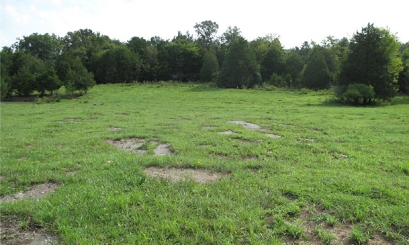
Figure 23. Typical pasture
The dominance of orchardgrass, red clover and tall fescue in this community phase indicate that nutrient levels are adequate and grazing rotations are long enough to allow pasture plants to recover. Overstocking and infrequent pasture rotation will allow weedier species to invade such as nimblewill and rush. If mowing is infrequent, honey locust and Eastern redcedar will begin to colonize. Patches of bare ground and rock outcrop are common in pastures on this site.
Forest overstory. The overstory in the grassland state is minimal and consists of a few trees growing along the perimeter of pastures and scattered shade trees within pastures.
Forest understory. Ideally, pastures in the grassland state would be primarily composed of tall fescue, red clover and orchardgrass. Numerous other plants could be present in varying numbers depending on the objectives and management approaches of the landowner.
Table 14. Ground cover
| Tree foliar cover | 0% |
|---|---|
| Shrub/vine/liana foliar cover | 0% |
| Grass/grasslike foliar cover | 0-50% |
| Forb foliar cover | 0-20% |
| Non-vascular plants | 0% |
| Biological crusts | 0% |
| Litter | 0-5% |
| Surface fragments >0.25" and <=3" | 0-3% |
| Surface fragments >3" | 0% |
| Bedrock | 0-2% |
| Water | 0% |
| Bare ground | 0-25% |
Table 15. Canopy structure (% cover)
| Height Above Ground (m) | Tree | Shrub/Vine | Grass/ Grasslike |
Forb |
|---|---|---|---|---|
| <0.15 | – | – | 0-50% | 0-40% |
| >0.15 <= 0.3 | – | – | 0-1% | 0-1% |
| >0.3 <= 0.6 | – | – | – | – |
| >0.6 <= 1.4 | – | – | – | – |
| >1.4 <= 4 | – | – | – | – |
| >4 <= 12 | – | – | – | – |
| >12 <= 24 | – | – | – | – |
| >24 <= 37 | – | – | – | – |
| >37 | – | – | – | – |
State 4
Transitional Field State
This is a transitional state representing an important step in the natural succession of this ecological site. In this state, the plant community is moving from a cleared or managed grassland state to a forested state, whether in reference condition or invaded. Typically, the plant community consists of a high number of grasses, both native and introduced. The types and amounts of grasses are largely related to past land-use. If the site was cleared but never grazed by domestic livestock or managed as a pasture, native warm-season grass species would be more common. Obviously, where land was cleared for pasture, species such as tall fescue would be present, along with a higher number of weedy exotics. This state will also contain a high number of native asters, including the goldenrods and the daisies, which can be important to pollinators and wildlife. One plot was on a wildlife management area, which was focused on dove habitat. Woody species that will begin to encroach include eastern redcedar, honeylocust, winged elm, black walnut (Juglans nigra), and boxelder (Acer negundo). Periodic mowing can keep this state in an open condition. In some areas, rock outcrop will naturally maintain openness. Mowing becomes almost impossible quickly, as honeylocust especially, begins to encroach. If openness is desired, mowing should be done at least once per year, if not more often. Exotic plant species can become a problem in this state, especially as it transitions over to the invaded state. Because of the openness and relatively short time period since clearance, it is susceptible to a host of non-native plant pests, which can change natural succession pathways and push this state into an invaded state rather than back to the reference community. The type and amount of past disturbance, the degree of interruption of natural disturbance cycles and the surrounding flora will all play a role in which trajectory and to what degree, this state can move. Typical exotic species found in this state include the privets, the exotic lespedezas, Nepalese browntop and the exotic honeysuckles to name a few. In most cases, this state will require some type of exotic plant management if it is to return to the reference plant community.
Community 4.1
Eastern redcedar/honeylocust – winged elm/tall fescue – red clover
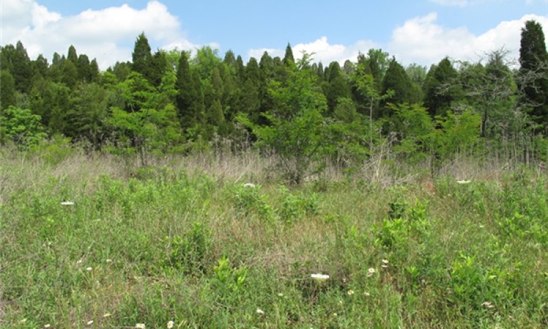
Figure 24. Transitional field
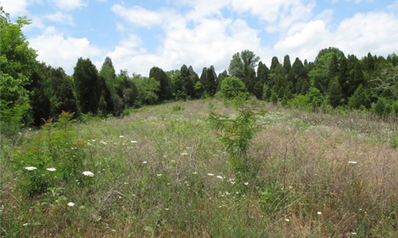
Figure 25. Mowed field being colonized by trees
This state is succeeding to forest in most cases. It will have varying degrees of openness based on depth to bedrock and, relatedly, soil depth. Naturally shallow areas will largely remain open while areas with deeper soil will host woody plant species. Typical early colonizers include eastern redcedar, honeylocust and winged elm. Succession happens rapidly on this state and so, if openness is desirable, mowing regimes must occur with regularity and relative frequency. In many cases, this site will be susceptible to invasion by exotic invasive plant species. If restoration to the reference plant community is desired, exotic plant management will likely be needed. It should be site based and species specific. The reintroduction of natural disturbances such as fire could be beneficial in some cases. However, it has also been known to spread invasive, exotic plants and so should be used with caution.
Forest overstory. This site has none to very little forest overstory but in some cases an individual tree will occur. In that case, species might include eastern redcedar, boxelder (Acer negundo), honeylocust, and black walnut (Juglans nigra).
Forest understory. Forest understories can be variable, depending on the type and degree of past disturbance and the plant composition of the surrounding landscape. If invasive exotics occur all around a site in this state, it will be much more likely to be colonized by problematic species. Concurrently, clearings that represent this state within a larger mosaic of forests and woodlands will be colonized by native pioneer woody species more rapidly and to a greater degree. Typical understory species can include native and exotic grasses, numerous genera in the Asteraceae family, lespedezas, and tree and shrub seedlings.
Transition 1A
State 1 to 2
The reference community can become susceptible to invasion by exotic plants if natural disturbance regimes are hampered, if there is a history of human-caused disturbance such as unrestricted grazing, and/or if a site is located close to an invaded area, such as a roadside. In some cases, eastern redcedar, a native species, can become invasive on glades.
Transition 1B
State 1 to 3
The reference community can be and has been in many cases, transitioned into a managed grassland. This requires typical pasture establishment techniques such as clearing trees, establishing pasture grasses and forbs and continuing management such as fertilizing, rotational grazing, etc.
Transition 1C
State 1 to 4
If an area is cleared of trees and abandoned, natural succession will begin and in a short amount of time, woody species such as eastern redcedar, honeylocust (Gleditsia triacanthos) and winged elm will dominate the site, making mowing almost impossible. In some places, these areas are intentionally kept open for wildlife. Mowing schedules should consider the rapid colonization of native woody species. In areas where succession starts from an abandoned pasture, species such as tall fescue and red clover may be present. These areas are particularly susceptible to invasion by exotic plant species.
Restoration pathway 2A
State 2 to 1
For glade areas where eastern redcedar has encroached, some mechanical/chemical clearing may be in order before any use of prescribed fire would be effective. In areas where there is a severe exotic plant invasion in addition to cedar encroachment, prescribed fire should be used with extreme caution. Fire is known to favor exotic plants and a misapplication could result in exacerbating the invasion extent. Management of exotic, invasive plants is critical to restore this state to reference conditions. Most invasions require long-term management over years, involving multiple treatments which can vary by species and extent of invasion. Management should be site based and species specific. Technical resources should be consulted to develop site-based management prescriptions.
Conservation practices
| Native Plant Community Restoration and Management | |
|---|---|
| Invasive Plant Species Control | |
| Herbaceous Weed Control |
Transition 3A
State 3 to 4
The managed grassland state will quickly begin to revert to forest, in most cases, once management and grazing stops. Typically, redcedar and honeylocust will be the first woody invaders and will dominate the site in very little time. Once established, these woody species, especially honeylocust, make it difficult to push this state back to a managed grassland because mowing becomes impossible at a point. Exotic plant species are commonly noted in areas transitioning from a managed grassland state to a different plant community. In some cases, exotic plant management will be needed, depending on management objectives.
Restoration pathway 4B
State 4 to 1
Depending on the degree of ecological degradation present on a site in this state, it can generally be restored back to a reference plant community through natural succession, exotic plant management and mechanical control of undesirable tree species. Encouraging oak regeneration can also help to push this state back into the reference community. In some cases, prescribed fire might be beneficial but care should be taken as it has been known to spread invasive, exotic plants.
Transition 4A
State 4 to 2
This state is likely to transition to the Invaded State if no management is done to control exotic species. Native trees will naturally seed in over time as well.
Restoration pathway 4A
State 4 to 3
This state can be returned to a managed grassland state with appropriate pasture management such as mowing, seeding and fertilizing.
Additional community tables
Table 16. Community 1.1 forest overstory composition
| Common name | Symbol | Scientific name | Nativity | Height (m) | Canopy cover (%) | Diameter (cm) | Basal area (square m/hectare) |
|---|---|---|---|---|---|---|---|
|
Tree
|
|||||||
| eastern redcedar | JUVI | Juniperus virginiana | Native | 4.9–13.1 | 5–50 | 10.2–27.9 | – |
| chinquapin oak | QUMU | Quercus muehlenbergii | Native | 12.5–21.3 | 5–40 | 17.8–30.5 | – |
| white ash | FRAM2 | Fraxinus americana | Native | 10.1–14.6 | 1–30 | 12.7–27.9 | – |
| Virginia pine | PIVI2 | Pinus virginiana | Native | 6.4–12.2 | 2–15 | 12.7–22.9 | – |
| northern red oak | QURU | Quercus rubra | Native | 18.9–21.9 | 0–5 | 22.9–27.9 | – |
| winged elm | ULAL | Ulmus alata | Native | 3–7 | 1–5 | 5.1–12.7 | – |
| sassafras | SAAL5 | Sassafras albidum | Native | 1.5–5.5 | 0–2 | 10.2–12.7 | – |
| eastern white pine | PIST | Pinus strobus | Native | 9.1–15.2 | 0–2 | 0–17.8 | – |
| flowering dogwood | COFL2 | Cornus florida | Native | 3.7–4.6 | 0–2 | 7.6–10.2 | – |
| common persimmon | DIVI5 | Diospyros virginiana | Native | 7.6–10.7 | 0–2 | 0–20.3 | – |
Table 17. Community 1.1 forest understory composition
| Common name | Symbol | Scientific name | Nativity | Height (m) | Canopy cover (%) | |
|---|---|---|---|---|---|---|
|
Grass/grass-like (Graminoids)
|
||||||
| panicgrass | PANIC | Panicum | Native | 0–0.2 | 0–1 | |
| purpletop tridens | TRFL2 | Tridens flavus | Native | 0–0.2 | 0–1 | |
| purpletop tridens | TRFL2 | Tridens flavus | Native | 0.2–0.3 | 0–1 | |
|
Forb/Herb
|
||||||
| trailing lespedeza | LEPR | Lespedeza procumbens | Native | 0–0.2 | 2–5 | |
| aster | ASTER | Aster | Native | 0.2–0.3 | 0–5 | |
| wavyleaf aster | SYUN | Symphyotrichum undulatum | Native | 0.2–0.3 | 1–3 | |
| agueweed | GEQUQ | Gentianella quinquefolia ssp. quinquefolia | Native | 0–0.2 | 2–3 | |
| goldenrod | SOLID | Solidago | Native | 0–0.2 | 1–2 | |
| white crownbeard | VEVI3 | Verbesina virginica | Native | 0.2–0.3 | 1–2 | |
| trailing lespedeza | LEPR | Lespedeza procumbens | Native | 0.2–0.3 | 1–2 | |
| sunflower | HELIA3 | Helianthus | Native | 0–0.2 | 1–2 | |
| sunflower | HELIA3 | Helianthus | Native | 0.2–0.3 | 1–2 | |
| ticktrefoil | DESMO | Desmodium | Native | 0–0.2 | 1–2 | |
| purple false foxglove | AGPU5 | Agalinis purpurea | Native | 0–0.2 | 1–2 | |
| bedstraw | GALIU | Galium | Native | 0–0.2 | 0–1 | |
| sericea lespedeza | LECU | Lespedeza cuneata | Introduced | 0–0.2 | 0–1 | |
| shaggy blazing star | LIPI7 | Liatris pilosa | Native | 0–0.2 | 0–1 | |
| trailing lespedeza | LEPR | Lespedeza procumbens | Native | 0–0.2 | 0–1 | |
| white crownbeard | VEVI3 | Verbesina virginica | Native | 0–0.2 | 0–1 | |
| Virginia strawberry | FRVI | Fragaria virginiana | Native | 0–0.2 | 0–1 | |
| wavyleaf aster | SYUN | Symphyotrichum undulatum | Native | 0–0.2 | 0–1 | |
| wild petunia | RUELL | Ruellia | Native | 0–0.2 | 0–1 | |
| smallhead blazing star | LIMI7 | Liatris microcephala | Native | 0–0.2 | 0–1 | |
|
Fern/fern ally
|
||||||
| resurrection fern | PLPO2 | Pleopeltis polypodioides | Native | 0–0.2 | 1–2 | |
| resurrection fern | PLPO2 | Pleopeltis polypodioides | Native | 0.2–0.3 | 1–2 | |
| resurrection fern | PLPO2 | Pleopeltis polypodioides | Native | 0.3–0.6 | 1–2 | |
| resurrection fern | PLPO2 | Pleopeltis polypodioides | Native | 0.6–1.4 | 1–2 | |
| resurrection fern | PLPO2 | Pleopeltis polypodioides | Native | 1.4–4 | 1–2 | |
| purple cliffbrake | PEAT2 | Pellaea atropurpurea | Native | 0–0.2 | 0–1 | |
|
Shrub/Subshrub
|
||||||
| rusty blackhaw | VIRU | Viburnum rufidulum | Native | 0.6–1.4 | 2–5 | |
| American beautyberry | CAAM2 | Callicarpa americana | Native | 0.6–1.4 | 1–4 | |
| fragrant sumac | RHAR4 | Rhus aromatica | Native | 0.3–0.6 | 1–3 | |
| autumn olive | ELUM | Elaeagnus umbellata | Introduced | 0.3–0.6 | 1–3 | |
| autumn olive | ELUM | Elaeagnus umbellata | Introduced | 0.6–1.4 | 1–3 | |
| dwarf hackberry | CETE | Celtis tenuifolia | Native | 1.4–4 | 1–3 | |
| rusty blackhaw | VIRU | Viburnum rufidulum | Native | 1.4–4 | 1–2 | |
| common serviceberry | AMAR3 | Amelanchier arborea | Native | 1.4–4 | 1–2 | |
| American bladdernut | STTR | Staphylea trifolia | Native | 0.6–1.4 | 1–2 | |
| fragrant sumac | RHAR4 | Rhus aromatica | Native | 0.2–0.3 | 1–2 | |
| Carolina buckthorn | FRCA13 | Frangula caroliniana | Native | 0.2–0.6 | 1–2 | |
| Amur honeysuckle | LOMA6 | Lonicera maackii | Introduced | 0–0.2 | 0–1 | |
| fragrant sumac | RHAR4 | Rhus aromatica | Native | 0–0.2 | 0–1 | |
| rusty blackhaw | VIRU | Viburnum rufidulum | Native | 0–0.2 | 0–1 | |
| autumn olive | ELUM | Elaeagnus umbellata | Introduced | 0–0.2 | 0–1 | |
| autumn olive | ELUM | Elaeagnus umbellata | Introduced | 0.2–0.3 | 0–1 | |
| autumn olive | ELUM | Elaeagnus umbellata | Introduced | 1.4–4 | 0–1 | |
| rusty blackhaw | VIRU | Viburnum rufidulum | Native | 0.2–0.3 | 0–1 | |
| rusty blackhaw | VIRU | Viburnum rufidulum | Native | 0.3–0.6 | 0–1 | |
| dwarf hackberry | CETE | Celtis tenuifolia | Native | 0–0.2 | 0–1 | |
| dwarf hackberry | CETE | Celtis tenuifolia | Native | 0.2–0.3 | 0–1 | |
| dwarf hackberry | CETE | Celtis tenuifolia | Native | 0.6–1.4 | 0–1 | |
| dwarf hackberry | CETE | Celtis tenuifolia | Native | 0–0.2 | 0–1 | |
| dwarf hackberry | CETE | Celtis tenuifolia | Native | 0.2–0.3 | 0–1 | |
| dwarf hackberry | CETE | Celtis tenuifolia | Native | 0.6–1.4 | 0–1 | |
| dwarf hackberry | CETE | Celtis tenuifolia | Native | 1.4–4 | 0–1 | |
| striped prince's pine | CHMA3 | Chimaphila maculata | Native | 0–0.2 | 0–1 | |
|
Tree
|
||||||
| winged elm | ULAL | Ulmus alata | Native | 1.4–4 | 2–8 | |
| eastern redcedar | JUVI | Juniperus virginiana | Native | 1.4–4 | 2–5 | |
| American beech | FAGR | Fagus grandifolia | Native | 1.4–4 | 1–4 | |
| shagbark hickory | CAOV2 | Carya ovata | Native | 0–0.2 | 1–4 | |
| eastern redcedar | JUVI | Juniperus virginiana | Native | 0.6–1.4 | 1–4 | |
| eastern redbud | CECA4 | Cercis canadensis | Native | 1.4–4 | 1–4 | |
| flowering dogwood | COFL2 | Cornus florida | Native | 1.4–4 | 2–4 | |
| eastern redbud | CECA4 | Cercis canadensis | Native | 0.6–1.4 | 1–3 | |
| chinquapin oak | QUMU | Quercus muehlenbergii | Native | 0.6–1.4 | 1–3 | |
| American beech | FAGR | Fagus grandifolia | Native | 0.6–1.4 | 1–2 | |
| eastern redbud | CECA4 | Cercis canadensis | Native | 0.2–0.3 | 1–2 | |
| eastern redbud | CECA4 | Cercis canadensis | Native | 0.3–0.6 | 1–2 | |
| eastern redbud | CECA4 | Cercis canadensis | Native | 0–0.2 | 1–2 | |
| shagbark hickory | CAOV2 | Carya ovata | Native | 0.3–0.6 | 1–2 | |
| shagbark hickory | CAOV2 | Carya ovata | Native | 0.6–1.4 | 1–2 | |
| shagbark hickory | CAOV2 | Carya ovata | Native | 1.4–4 | 1–2 | |
| winged elm | ULAL | Ulmus alata | Native | 0.2–0.3 | 1–2 | |
| winged elm | ULAL | Ulmus alata | Native | 0.3–0.6 | 1–2 | |
| sugar maple | ACSA3 | Acer saccharum | Native | 0.3–0.6 | 1–2 | |
| sugar maple | ACSA3 | Acer saccharum | Native | 0.6–1.4 | 1–2 | |
| sugar maple | ACSA3 | Acer saccharum | Native | 1.4–4 | 1–2 | |
| sugar maple | ACSA3 | Acer saccharum | Native | 0–0.2 | 1–2 | |
| sugar maple | ACSA3 | Acer saccharum | Native | 0.2–0.3 | 1–2 | |
| Shumard oak | QUSHS2 | Quercus shumardii var. shumardii | Native | 0–0.2 | 0–1 | |
| slippery elm | ULRU | Ulmus rubra | Native | 1.4–4 | 0–1 | |
| white ash | FRAM2 | Fraxinus americana | Native | 0–0.2 | 0–1 | |
| white ash | FRAM2 | Fraxinus americana | Native | 0.2–0.3 | 0–1 | |
| winged elm | ULAL | Ulmus alata | Native | 0–0.2 | 0–1 | |
| dwarf hackberry | CETE | Celtis tenuifolia | Native | 0.3–0.6 | 0–1 | |
| ash | FRAXI | Fraxinus | Native | 0–0.2 | 0–1 | |
| eastern redcedar | JUVI | Juniperus virginiana | Native | 0–0.2 | 0–1 | |
| eastern redcedar | JUVI | Juniperus virginiana | Native | 0.2–0.3 | 0–1 | |
| eastern redcedar | JUVI | Juniperus virginiana | Native | 0.3–0.6 | 0–1 | |
| black cherry | PRSE2 | Prunus serotina | Native | 0–0.2 | 0–1 | |
| chinquapin oak | QUMU | Quercus muehlenbergii | Native | 0–0.2 | 0–1 | |
| chinquapin oak | QUMU | Quercus muehlenbergii | Native | 0.2–0.3 | 0–1 | |
| chinquapin oak | QUMU | Quercus muehlenbergii | Native | 0.3–0.6 | 0–1 | |
| post oak | QUST | Quercus stellata | Native | 0–0.3 | 0–1 | |
| chinquapin oak | QUMU | Quercus muehlenbergii | Native | 1.4–4 | 0–1 | |
| common persimmon | DIVI5 | Diospyros virginiana | Native | 0–0.2 | 0–1 | |
| flowering dogwood | COFL2 | Cornus florida | Native | 0.6–1.4 | 0–1 | |
| red maple | ACRU | Acer rubrum | Native | 0–0.2 | 0–1 | |
|
Vine/Liana
|
||||||
| trumpet creeper | CARA2 | Campsis radicans | Native | 0–0.2 | 1–2 | |
| trumpet creeper | CARA2 | Campsis radicans | Native | 0.2–0.3 | 1–2 | |
| Virginia creeper | PAQU2 | Parthenocissus quinquefolia | Native | 0.2–0.3 | 1–2 | |
| Virginia creeper | PAQU2 | Parthenocissus quinquefolia | Native | 0–0.2 | 0–1 | |
| Virginia creeper | PAQU2 | Parthenocissus quinquefolia | Native | 0.3–0.6 | 0–1 | |
| common moonseed | MECA3 | Menispermum canadense | Native | 0–0.2 | 0–1 | |
| common moonseed | MECA3 | Menispermum canadense | Native | 0.2–0.3 | 0–1 | |
| common moonseed | MECA3 | Menispermum canadense | Native | 0.3–0.6 | 0–1 | |
| crossvine | BICA | Bignonia capreolata | Native | 0–0.2 | 0–1 | |
| crossvine | BICA | Bignonia capreolata | Native | 0.2–0.3 | 0–1 | |
| crossvine | BICA | Bignonia capreolata | Native | 0.3–0.6 | 0–1 | |
| crossvine | BICA | Bignonia capreolata | Native | 0.6–1.4 | 0–1 | |
| crossvine | BICA | Bignonia capreolata | Native | 0.6–1.4 | 0–1 | |
| devil's darning needles | CLVI5 | Clematis virginiana | Native | 0.3–0.6 | 0–1 | |
| common moonseed | MECA3 | Menispermum canadense | Native | 0–0.2 | 0–1 | |
| common moonseed | MECA3 | Menispermum canadense | Native | 0.2–0.3 | 0–1 | |
| common moonseed | MECA3 | Menispermum canadense | Native | 0.3–0.6 | 0–1 | |
| eastern poison ivy | TORA2 | Toxicodendron radicans | Native | 0.2–0.3 | 0–1 | |
| eastern poison ivy | TORA2 | Toxicodendron radicans | Native | 0.3–0.6 | 0–1 | |
| eastern poison ivy | TORA2 | Toxicodendron radicans | Native | 0.6–1.4 | 0–1 | |
| grape | VITIS | Vitis | Native | 0–0.2 | 0–1 | |
| grape | VITIS | Vitis | Native | 0.2–0.3 | 0–1 | |
| greenbrier | SMILA2 | Smilax | – | 0–0.2 | 0–1 | |
| greenbrier | SMILA2 | Smilax | Native | 0.6–1.4 | 0–1 | |
| roundleaf greenbrier | SMRO | Smilax rotundifolia | Native | 0–0.2 | 0–1 | |
| roundleaf greenbrier | SMRO | Smilax rotundifolia | Native | 0.2–0.3 | 0–1 | |
| roundleaf greenbrier | SMRO | Smilax rotundifolia | Native | 0.3–0.6 | 0–1 | |
| eastern poison ivy | TORA2 | Toxicodendron radicans | Native | 0–0.2 | 0–1 | |
| crossvine | BICA | Bignonia capreolata | Native | 1.4–4 | 0–1 | |
Table 18. Community 1.2 forest overstory composition
| Common name | Symbol | Scientific name | Nativity | Height (m) | Canopy cover (%) | Diameter (cm) | Basal area (square m/hectare) |
|---|---|---|---|---|---|---|---|
|
Tree
|
|||||||
| eastern redcedar | JUVI | Juniperus virginiana | Native | 1.2–6.1 | 5–10 | 5.1–38.1 | – |
| winged elm | ULAL | Ulmus alata | Native | 1.2–2.4 | 0–2 | 5.1–12.7 | – |
| Virginia pine | PIVI2 | Pinus virginiana | Native | 6.4–12.2 | 0–2 | 17.8–30.5 | – |
| eastern redbud | CECA4 | Cercis canadensis | Native | – | 0–1 | – | – |
Table 19. Community 1.2 forest understory composition
| Common name | Symbol | Scientific name | Nativity | Height (m) | Canopy cover (%) | |
|---|---|---|---|---|---|---|
|
Grass/grass-like (Graminoids)
|
||||||
| little bluestem | SCSC | Schizachyrium scoparium | Native | 0–0.3 | 0–5 | |
| broomsedge bluestem | ANVI2 | Andropogon virginicus | Native | – | – | |
| bald brome | BRRA2 | Bromus racemosus | Introduced | – | – | |
| eastern woodland sedge | CABL | Carex blanda | Native | – | – | |
| orchardgrass | DAGL | Dactylis glomerata | Introduced | – | – | |
| purpletop tridens | TRFL2 | Tridens flavus | Native | – | – | |
| composite dropseed | SPCOC2 | Sporobolus compositus var. compositus | Native | – | – | |
| poverty dropseed | SPVA | Sporobolus vaginiflorus | Native | – | – | |
| meadow fescue | SCPR4 | Schedonorus pratensis | Introduced | – | – | |
| Bosc's panicgrass | DIBO2 | Dichanthelium boscii | Native | – | – | |
| poverty oatgrass | DASP2 | Danthonia spicata | Native | – | – | |
| gonolobus | GONOL | Gonolobus | Introduced | – | – | |
| wiry panicgrass | PAFL2 | Panicum flexile | Native | – | – | |
|
Forb/Herb
|
||||||
| pinnate prairie coneflower | RAPI | Ratibida pinnata | Native | – | 0–5 | |
| gladecress | LEAVE | Leavenworthia | Native | – | – | |
| daisy | CHRYS2 | Chrysanthemum | Introduced | – | – | |
| Queen Anne's lace | DACA6 | Daucus carota | Introduced | – | – | |
| hairyfruit chervil | CHTA | Chaerophyllum tainturieri | Native | – | – | |
| fivestamen chickweed | CESE4 | Cerastium semidecandrum | Introduced | – | – | |
| redring milkweed | ASVA | Asclepias variegata | Native | – | – | |
| wild bergamot | MOFI | Monarda fistulosa | Native | – | – | |
| woodland pinkroot | SPMA3 | Spigelia marilandica | Native | – | – | |
| diamondflowers | STNIN | Stenaria nigricans var. nigricans | Native | – | – | |
| tall thimbleweed | ANVI3 | Anemone virginiana | Native | – | – | |
| violet | VIOLA | Viola | Unknown | – | – | |
| common chickweed | STME2 | Stellaria media | Introduced | – | – | |
| lyreleaf sage | SALY2 | Salvia lyrata | Native | – | – | |
| Leonard's skullcap | SCPAM | Scutellaria parvula var. missouriensis | Native | – | – | |
| clover | TRIFO | Trifolium | Unknown | – | – | |
| goldenrod | SOLID | Solidago | Native | – | – | |
| Virginia plantain | PLVI | Plantago virginica | Native | – | – | |
| false aloe | MAVI5 | Manfreda virginica | Native | – | – | |
| licorice bedstraw | GACI2 | Galium circaezans | Native | – | – | |
| hairy sunflower | HEHI2 | Helianthus hirsutus | Native | – | – | |
| Carolina geranium | GECA5 | Geranium carolinianum | Native | – | – | |
| flowering spurge | EUCO10 | Euphorbia corollata | Native | – | – | |
| hoary puccoon | LICA12 | Lithospermum canescens | Native | – | – | |
| trailing lespedeza | LEPR | Lespedeza procumbens | Native | – | – | |
| common yellow oxalis | OXST | Oxalis stricta | Native | – | – | |
| foxglove beardtongue | PEDI | Penstemon digitalis | Native | – | – | |
| Allegheny-spurge | PAPR7 | Pachysandra procumbens | Native | – | – | |
| garden vetch | VISAN2 | Vicia sativa ssp. nigra | Introduced | – | – | |
| violet woodsorrel | OXVI | Oxalis violacea | Native | – | – | |
|
Fern/fern ally
|
||||||
| purple cliffbrake | PEAT2 | Pellaea atropurpurea | Native | 0–0.2 | 0–1 | |
| glade fern | DIPY | Diplazium pycnocarpon | Native | – | – | |
| resurrection fern | PLPOP | Pleopeltis polypodioides ssp. polypodioides | Native | – | – | |
|
Shrub/Subshrub
|
||||||
| fragrant sumac | RHAR4 | Rhus aromatica | Native | 0–0.2 | 0–1 | |
| fragrant sumac | RHAR4 | Rhus aromatica | Native | 0.2–0.3 | 0–1 | |
| fragrant sumac | RHAR4 | Rhus aromatica | Native | 0.3–0.6 | 0–1 | |
| fragrant sumac | RHAR4 | Rhus aromatica | Native | 0.6–1.4 | 0–1 | |
|
Vine/Liana
|
||||||
| saw greenbrier | SMBO2 | Smilax bona-nox | Native | 0–0.2 | 0–1 | |
| saw greenbrier | SMBO2 | Smilax bona-nox | Native | 0.2–0.3 | 0–1 | |
| saw greenbrier | SMBO2 | Smilax bona-nox | Native | 0.3–0.6 | 0–1 | |
| saw greenbrier | SMBO2 | Smilax bona-nox | Native | 0.6–1.4 | 0–1 | |
| trumpet honeysuckle | LOSE | Lonicera sempervirens | Native | – | 0–1 | |
Table 20. Community 2.1 forest overstory composition
| Common name | Symbol | Scientific name | Nativity | Height (m) | Canopy cover (%) | Diameter (cm) | Basal area (square m/hectare) |
|---|---|---|---|---|---|---|---|
|
Tree
|
|||||||
| eastern redcedar | JUVI | Juniperus virginiana | Native | 7.6–16.2 | 0–40 | 22.9–30.5 | – |
| chinquapin oak | QUMU | Quercus muehlenbergii | Native | 4.6–18.3 | 0–10 | 10.2–20.3 | – |
| post oak | QUST | Quercus stellata | Native | 13.7–20.7 | 0–10 | 20.3–43.2 | – |
| silktree | ALJU | Albizia julibrissin | Introduced | – | – | 33 | – |
| elm | ULMUS | Ulmus | Native | 12.2–18.3 | – | 17.8–30.5 | – |
| Shumard oak | QUSHS2 | Quercus shumardii var. shumardii | Native | 13.7–18.3 | – | 22.9 | – |
| shagbark hickory | CAOV2 | Carya ovata | Native | – | – | 0–50.8 | – |
| white ash | FRAM2 | Fraxinus americana | Native | – | – | 0–30.5 | – |
| common persimmon | DIVI5 | Diospyros virginiana | Native | – | – | 0–22.9 | – |
| mockernut hickory | CATO6 | Carya tomentosa | Native | – | – | 0–30.5 | – |
| white oak | QUAL | Quercus alba | Native | – | – | 0–22.9 | – |
| Virginia pine | PIVI2 | Pinus virginiana | Native | – | – | 0–33 | – |
Table 21. Community 2.1 forest understory composition
| Common name | Symbol | Scientific name | Nativity | Height (m) | Canopy cover (%) | |
|---|---|---|---|---|---|---|
|
Grass/grass-like (Graminoids)
|
||||||
| Nepalese browntop | MIVI | Microstegium vimineum | Introduced | 0–0.2 | 50–75 | |
|
Forb/Herb
|
||||||
| sericea lespedeza | LECU | Lespedeza cuneata | Introduced | – | – | |
|
Fern/fern ally
|
||||||
| resurrection fern | PLPO2 | Pleopeltis polypodioides | Native | 0–4 | 0–2 | |
|
Shrub/Subshrub
|
||||||
| Amur honeysuckle | LOMA6 | Lonicera maackii | Introduced | – | 5–25 | |
| Chinese privet | LISI | Ligustrum sinense | Introduced | – | 5–25 | |
| Dahurian buckthorn | RHDA | Rhamnus davurica | Introduced | – | 0–5 | |
| winter creeper | EUFO5 | Euonymus fortunei | Introduced | – | – | |
| autumn olive | ELUM | Elaeagnus umbellata | Introduced | – | – | |
| burningbush | EUAL13 | Euonymus alatus | Introduced | – | – | |
|
Tree
|
||||||
| American beech | FAGR | Fagus grandifolia | Native | – | 0–5 | |
| eastern redbud | CECA4 | Cercis canadensis | Native | 0.6–1.4 | 2–5 | |
| paper mulberry | BRPA4 | Broussonetia papyrifera | Introduced | – | 0–2 | |
| white ash | FRAM2 | Fraxinus americana | Native | 0.2–0.6 | 0–1 | |
| eastern redbud | CECA4 | Cercis canadensis | Native | – | 0–1 | |
| dwarf hackberry | CETE | Celtis tenuifolia | Native | – | 0–1 | |
| tree of heaven | AIAL | Ailanthus altissima | Introduced | – | – | |
| Callery pear | PYCA80 | Pyrus calleryana | Introduced | – | – | |
|
Vine/Liana
|
||||||
| English ivy | HEHE | Hedera helix | Introduced | – | 5–75 | |
| Japanese honeysuckle | LOJA | Lonicera japonica | Introduced | – | 0–10 | |
| trumpet creeper | CARA2 | Campsis radicans | Native | 0–4 | 0–5 | |
| grape | VITIS | Vitis | Native | 0–12.2 | 1–2 | |
| eastern poison ivy | TORA2 | Toxicodendron radicans | Native | – | 1–2 | |
| crossvine | BICA | Bignonia capreolata | Native | 0.2–0.3 | 0–1 | |
| Chinese wisteria | WISI | Wisteria sinensis | Introduced | – | – | |
Table 22. Community 3.1 forest overstory composition
| Common name | Symbol | Scientific name | Nativity | Height (m) | Canopy cover (%) | Diameter (cm) | Basal area (square m/hectare) |
|---|---|---|---|---|---|---|---|
|
Tree
|
|||||||
| post oak | QUST | Quercus stellata | Native | – | – | – | – |
| shagbark hickory | CAOV2 | Carya ovata | Native | – | – | – | – |
| common persimmon | DIVI5 | Diospyros virginiana | Native | – | – | – | – |
| eastern redcedar | JUVI | Juniperus virginiana | Native | – | – | – | – |
Table 23. Community 3.1 forest understory composition
| Common name | Symbol | Scientific name | Nativity | Height (m) | Canopy cover (%) | |
|---|---|---|---|---|---|---|
|
Grass/grass-like (Graminoids)
|
||||||
| panicgrass | PANIC | Panicum | Unknown | – | – | |
| broomsedge bluestem | ANVI2 | Andropogon virginicus | Native | – | – | |
| field brome | BRAR5 | Bromus arvensis | Introduced | – | – | |
| purpletop tridens | TRFL2 | Tridens flavus | Native | – | – | |
| purpletop tridens | TRFL2 | Tridens flavus | Native | – | – | |
| tall fescue | SCAR7 | Schedonorus arundinaceus | Introduced | – | – | |
| orchardgrass | DAGL | Dactylis glomerata | Introduced | – | – | |
| Kentucky bluegrass | POPR | Poa pratensis | Introduced | – | – | |
| Nepalese browntop | MIVI | Microstegium vimineum | Introduced | – | – | |
| crabgrass | DIGIT2 | Digitaria | Unknown | – | – | |
|
Forb/Herb
|
||||||
| hogwort | CRCA6 | Croton capitatus | Native | – | – | |
| red clover | TRPR2 | Trifolium pratense | Introduced | – | – | |
| Queen Anne's lace | DACA6 | Daucus carota | Introduced | – | – | |
| Carolina wild petunia | RUCA4 | Ruellia caroliniensis | Native | – | – | |
| vetch | VICIA | Vicia | Unknown | – | – | |
| white clover | TRRE3 | Trifolium repens | Introduced | – | – | |
| lespedeza | LESPE | Lespedeza | Unknown | – | – | |
| narrowleaf plantain | PLLA | Plantago lanceolata | Introduced | – | – | |
| fleabane | ERIGE2 | Erigeron | Unknown | – | – | |
| blessed thistle | CNBE | Cnicus benedictus | Introduced | – | – | |
| ragweed | AMBRO | Ambrosia | Native | – | – | |
|
Vine/Liana
|
||||||
| Carolina coralbead | COCA | Cocculus carolinus | Native | – | – | |
Table 24. Community 4.1 forest overstory composition
| Common name | Symbol | Scientific name | Nativity | Height (m) | Canopy cover (%) | Diameter (cm) | Basal area (square m/hectare) |
|---|---|---|---|---|---|---|---|
|
Tree
|
|||||||
| black walnut | JUNI | Juglans nigra | Native | – | – | – | – |
| eastern redcedar | JUVI | Juniperus virginiana | Native | – | – | – | – |
| boxelder | ACNE2 | Acer negundo | Native | – | – | – | – |
Table 25. Community 4.1 forest understory composition
| Common name | Symbol | Scientific name | Nativity | Height (m) | Canopy cover (%) | |
|---|---|---|---|---|---|---|
|
Grass/grass-like (Graminoids)
|
||||||
| bluegrass | POA | Poa | Unknown | – | – | |
|
Forb/Herb
|
||||||
| lespedeza | LESPE | Lespedeza | Unknown | – | – | |
|
Tree
|
||||||
| honeylocust | GLTR | Gleditsia triacanthos | Native | – | – | |
| boxelder | ACNE2 | Acer negundo | Native | – | – | |
| eastern redcedar | JUVI | Juniperus virginiana | Native | – | – | |
Interpretations
Animal community
The dry calcareous forest state of this site is very important to wildlife. Mammals include the eastern chipmunk, short-tailed shrew, pine vole, gray squirrel, white-tailed deer, golden mouse, gray fox, striped skunk, eastern spotted skunk, least shrew, southern flying squirrel, opossum, and raccoon (Edwards et al. 2013). Bats can include the hoary, little brown, evening, eastern pipistrelle, and big brown. The Indiana bat is the primary threatened and endangered bat species. Shaggy bark (e.g., shagbark hickory) and scaly bark species provide excellent roosting sites for this bat. The Northern long eared bat is not listed yet, but is expected to be and would also use associated trees as roosting sites.
Bird species are similar to other forested ecological sites nearby. The Appalachian region, the location of this ecological site, is the center of the summer breeding range of neotropical migratory birds. Neotropical migrants include forest-interior, forest-edge, and early-successional species and comprise 65 to 85 percent of breeding birds (Smith, 1995).
Few amphibians are present because this site can be so dry but reptiles are common in this environment. Lizards can include southeastern five-lined skinks and eastern fence lizards. Burrowing snakes common in dry forests are the smooth earth and southeastern crowned snakes. Larger snakes include black racers and the semi-arboreal rat snake (Edwards et al. 2013).
The more open glade environments that occur within the vegetation mosaic of this ecological site can be very important to wildlife. Many bird species will use glades depending on the composition and structure of the vegetation. Eastern towhees, brown thrashers, and gray catbirds nest in shrub thickets, as will white-eyed vireos, indigo buntings, and common yellowthroats (Edwards et al. 2013). Common nighthawks might nest in these areas, as they place their eggs directly on the ground (Poulin et al. 1996). Cedar waxwings feed heavily on the arils of the eastern redcedar from late fall through early spring (Edwards et al. 2013). It also provides valuable cover and food for numerous other species including chipping sparrows, robins, song sparrows, and mockingbirds (Martin et al. 1951).
Reptiles that occur on these more open environments within this site can include six-lined racerunners, slender glass lizards, five-lined skinks and eastern fence lizards (Edwards et al. 2013). Common snakes include coachwhips, black racers, corn snakes, rat snakes, copperheads and timber rattlesnakes (Edwards et al. 2013). Notably, copperheads and timber rattlesnakes are poisonous to humans.
Numerous invertebrates graze on the vegetation, pollinate flowering plants and provide food sources for larger fauna (Edwards et al. 2013). One study in Tennessee found over 400 species of invertebrates in the open areas with ants comprising over half of all species (Quarterman et al. 1993, citing Meyer 1937).
The transitional field state on this ecological site is of particular value to wildlife and often occurs as a result of wildlife management. Much of the site occurs as public land, owned by wildlife resources agencies. One field sampled for this state was being managed for dove habitat but numerous game birds would benefit from the vegetation structure of this state.
Several plant species that occur commonly on this state are beneficial to wildlife. In particular, the hickories provide a valuable food source for squirrels and chipmunks as well as other wildlife species (Martin et al. 1951). Chinquapin oak is probably the most important species occurring on this site in terms of food. Acorns rate at or near the top of the wildlife food list. This is not so much because they are widely preferred as they are widely available. Martin et al. (1951) considered acorns a staple for many wildlife species and called them "the stuff of life."
Recreational uses
This ecological site is associated with multiple sources of recreation, some sustainable and some not. Throughout the range of the site private easements, nature centers, county parks, and state wildlife management areas are included. Much of the field sampling for this site was done on these protected lands.
Hunting on wildlife management areas is a common activity associated with the transitional field state of this ecological site. The early successional habitat (a mix of forbs, grasses and small woody trees and shrubs) provides good habitat for several game birds of interest to hunters. Open conditions favor multiple species that hunters are interested in. In some areas, a matrix of vegetation is maintained for maximum wildlife value. Examples of Wildlife Management Areas (WMAs) containing this ecological site in Tennessee include Eastern State WMA, Yuchi WMA, and Armstrong Ferry WMA.
Mountain biking has become a popular sport associated with this ecological site, especially in Knox and Anderson counties (TN). In some cases, this activity can be detrimental in that it causes erosion, especially in steeper areas. The shallow limestone soils degrade easily. However, the biking community has done wonders to conserve property that contains this site. Areas where mountain biking is currently occurring include Haw Ridge Park, the Knoxville Urban Wilderness, and I.C. King Park. Hikers and wildlife viewers also utilize biking trails in most cases.
Wood products
Due to the extremely shallow soils, this site is not conducive for forestry. Although some trees could be harvested, in most cases the ends would not justify the means as it is too rocky for easy access with equipment.
Supporting information
Inventory data references
ESD is based on 38 plots, including 6 tier 3 plots for the reference community. Hal DeSelm's data were used where plot locations could be verified. Type locations are only provided for reference plots.
Type locality
| Location 1: Meigs County, TN | |
|---|---|
| Latitude | 35° 26′ 82″ |
| Longitude | 84° 58′ 41″ |
| General legal description | Armstrong Ferry Wildlife Management Area in Meigs County off Armstrong Ferry Road. |
| Location 2: Meigs County, TN | |
| Latitude | 35° 26′ 37″ |
| Longitude | 84° 58′ 27″ |
| General legal description | Armstrong Ferry WMA |
| Location 3: Meigs County, TN | |
| Latitude | 35° 24′ 34″ |
| Longitude | 85° 0′ 21″ |
| General legal description | Reference plot at Cherokee Removal Park in Meigs County, TN near Route 60. |
| Location 4: Rhea County, TN | |
| UTM zone | N |
| UTM northing | 35.57497 |
| UTM easting | 84.84277 |
| General legal description | Reference plot on Yuchi Wildlife Management Area in Rhea County. Soils mapped Bre (Barfield rock outcrop). |
| Location 5: Walker County, GA | |
| Latitude | 34° 49′ 8″ |
| Longitude | 85° 24′ 31″ |
| General legal description | Reference plot on Lookout Mountain in Walker County, GA. Soils mapped Barfield rock outcrop Talbott. Plot is on the Barfield component. |
| Location 6: Anderson County, TN | |
| Latitude | 36° 0′ 10″ |
| Longitude | 84° 10′ 37″ |
| General legal description | Reference plot at Haw Ridge park in Anderson County, TN. |
Other references
Literature Cited:
Apsley, David and S. Gehert. 2006. Enhancing food (mast) production for woodland wildlife in Ohio. Extension Fact Sheet F-60-06, Ohio State University Extension, School of Natural Resources, Columbus, OH.
Baskin, J.M. and C.C. Baskin. 1996. The Grindelia lanceolata plant community type in cedar glades of the central basin of Tennessee. Castanea 61: 339-347.
Braun, E. Lucy. 1947. Development of the Deciduous Forests of Eastern North America. Ecological Monographs 17(2): 211 - 219.
Buol, Stan W., F.D. Hole, R.J. McCracken, R.J. Southard. 1997. Soil Genesis and Classification (4th ed.). Ames, Iowa: Iowa State University Press. Pp. 353 - 359.
Case, Earl C. 1925. The valley of east Tennessee: The adjustment of industry to natural environment. Bulletin 36. Division of Geology, Nashville, Tennessee.
Chapman, Jefferson, P.A. Delcourt, P.A. Cridlebaugh, A.B. Shea, and H.R. Delcourt. 1982. Man-land interaction: 10,000 years of American Indian impact on native ecosystems in the lower little Tennessee River valley, eastern Tennessee. Southeastern Archaeology 1: 115–121.
Cofer, M.S., J.L. Walck, and S.N. Hidayati. 2008. Species richness and exotic species invasion in middle Tennessee cedar glades in relation to abiotic and biotic factors. Journal of the Torrey Botanical Society 135(4): 540-553.
DeSelm, Hal. R. 1984. Potential national natural landmarks of the Appalachian ranges natural region: Ecological report. University of Tennessee, Knoxville.
DeSelm, Hal. R. 1994. Tennessee Barrens. Castanea 59(3): 214 - 225.
Edwards, Leslie, J. Ambrose, and L. K. Kirkman. 2013. The Natural Communities of Georgia. The University of Georgia Press.
Green, Jonathan D., W.W. Witt, and J.R. Martin. 2006. Weed management in grass pastures, hayfields, and other farmstead sites. University of Kentucky Cooperative Extension Service publication AGR-172.
Johnson, E.A. 1952. Effect of farm woodland grazing on watershed values in the southern Appalachian Mountains. Journal of Forestry 50(2): 109 – 113.
Lawless, P.J., J.M. Baskin, and C.C. Baskin. 2006. Xeric Limestone Prairies of Eastern United States: Review and Synthesis. The Botanical Review 72(3): 235-272.
Lorimer, Craig G. 2001. Historical and ecological roles of disturbance in Eastern North American forests: 9,000 years of change. Wildlife Society Bulletin 29: 425–439.
Martin, Alexander C., H.C. Zim, and A.L. Nelson. 1951. American wildlife and plants: A guide to wildlife food habits. Dover, New York, New York, USA.
Martin, William H. 1971. Forest communities of the dissected uplands in the Great Valley of east Tennessee and their relationship to soil and topographic properties. PhD Dissertation. The University of Tennessee, Knoxville.
Martin, William H. 1989. Forest patterns in the Great Valley of Tennessee. Journal of the Tennessee Academy of Science 64(3): 137 – 143.
NatureServe. 2014. NatureServe Explorer: An online encyclopedia of life [web application]. Version 7.1. NatureServe, Arlington, Virginia. Available http://explorer.natureserve.org. (Accessed: February 3, 2015 ).
Poulin, R.G., S.D. Grindal, and R.M. Brigham. 1996. Common nighthawk (Chordeiles minor). In Poole and F. Gill, eds., The Birds of North America, no. 213. Philadelphia: Academy of Natural Sciences; Washington, D.C.: American Ornithologists' Union.
Quarterman, Elsie M., M.P. Burbanck, and D.J. Shure. 1993. Rock outcrop communities: Limestone, sandstone, and granite. Pp. 35 - 86 in W.H. Martin, S.G. Boyce, and A.C. Echternacht, eds., Biodiversity of the Southeastern United States: Upland Terrestrial Communities. New York: Wiley.
Rhodes, G. Neil Jr., and W.P. Phillips Jr. 2012. PB1801 Weed Management in Pastures and Hay Crops, http://trace.tennessee.edu/utk_agexcrop/157.
Steckel, Larry and N. Rhodes. 2007. Perilla mint. University of Tennessee Extension Service publication W135.
Tennessee Exotic Pest Plant Council. Tennessee's Native Plant Alternatives to Exotic Invasives: A Garden and Landscape Guide (Accessed: February 6, 2015).
Thornthwaite, Charles W. 1948. An approach toward a rational classification of climate. Geographical Review 38(1): 55-94.
Williams, Samuel C. 1928. Early travels in the Tennessee country, 1540-1800: With introductions, annotations and index. The Watauga Press, Johnson City, Tennessee.
Contributors:
Jennifer Mason, USDA-NRCS
Dillon Gray, USDA-NRCS
Nathan Hartgrove, USDA-NRCS
David Moore, USDA-NRCS
Alfred Schotz, Alabama Natural Heritage
Dr. Stacy Clark, USFS
Matt Walker, USDA-NRCS
Barry Hart, USDA-NRCS
Allison Mains, University of Tennessee
Contributors
Belinda Esham
Belinda Esham Ferro
Rangeland health reference sheet
Interpreting Indicators of Rangeland Health is a qualitative assessment protocol used to determine ecosystem condition based on benchmark characteristics described in the Reference Sheet. A suite of 17 (or more) indicators are typically considered in an assessment. The ecological site(s) representative of an assessment location must be known prior to applying the protocol and must be verified based on soils and climate. Current plant community cannot be used to identify the ecological site.
| Author(s)/participant(s) | |
|---|---|
| Contact for lead author | |
| Date | |
| Approved by | |
| Approval date | |
| Composition (Indicators 10 and 12) based on | Annual Production |
Indicators
-
Number and extent of rills:
-
Presence of water flow patterns:
-
Number and height of erosional pedestals or terracettes:
-
Bare ground from Ecological Site Description or other studies (rock, litter, lichen, moss, plant canopy are not bare ground):
-
Number of gullies and erosion associated with gullies:
-
Extent of wind scoured, blowouts and/or depositional areas:
-
Amount of litter movement (describe size and distance expected to travel):
-
Soil surface (top few mm) resistance to erosion (stability values are averages - most sites will show a range of values):
-
Soil surface structure and SOM content (include type of structure and A-horizon color and thickness):
-
Effect of community phase composition (relative proportion of different functional groups) and spatial distribution on infiltration and runoff:
-
Presence and thickness of compaction layer (usually none; describe soil profile features which may be mistaken for compaction on this site):
-
Functional/Structural Groups (list in order of descending dominance by above-ground annual-production or live foliar cover using symbols: >>, >, = to indicate much greater than, greater than, and equal to):
Dominant:
Sub-dominant:
Other:
Additional:
-
Amount of plant mortality and decadence (include which functional groups are expected to show mortality or decadence):
-
Average percent litter cover (%) and depth ( in):
-
Expected annual annual-production (this is TOTAL above-ground annual-production, not just forage annual-production):
-
Potential invasive (including noxious) species (native and non-native). List species which BOTH characterize degraded states and have the potential to become a dominant or co-dominant species on the ecological site if their future establishment and growth is not actively controlled by management interventions. Species that become dominant for only one to several years (e.g., short-term response to drought or wildfire) are not invasive plants. Note that unlike other indicators, we are describing what is NOT expected in the reference state for the ecological site:
-
Perennial plant reproductive capability:
Print Options
Sections
Font
Other
The Ecosystem Dynamics Interpretive Tool is an information system framework developed by the USDA-ARS Jornada Experimental Range, USDA Natural Resources Conservation Service, and New Mexico State University.
Click on box and path labels to scroll to the respective text.