Natural Resources
Conservation Service
Ecological site F130AY003PA
Phyllite-Metasandstone Upland
Last updated: 9/27/2024
Accessed: 02/07/2026
General information
Provisional. A provisional ecological site description has undergone quality control and quality assurance review. It contains a working state and transition model and enough information to identify the ecological site.
MLRA notes
Major Land Resource Area (MLRA): 130A–Northern Blue Ridge
Major Land Resource Area 130A is in the Northern Section of the Blue Ridge Province of the Appalachian Highlands. The region is characterized by rugged mountains with steep slopes, sharp crests, and narrow valleys. The mountain range forms a narrow band that runs north to south between the Piedmont Upland Section to the east, the Ridge and Valley section to the west, and the Southern Section of the Blue Ridge to the south. Stream dissection is deep and intricate. Major streams and their tributaries flow through gorges and gaps. Elevation ranges from about 820 feet (250 meters) in the lower valleys and on footslopes along the Potomac River just east of Harpers Ferry, where West Virginia joins Maryland and Virginia, to more than 4,200 feet (1,280 meters) along the Appalachian Trail in Bedford County, Virginia. Apple Orchard Mountain, the highest peak, is at an elevation of 4,225 feet (1,288 meters) (USDA 2006).
The backbone of the northern Blue Ridge is an anticline composed of rocks that can be can be divided into geological groupings based on age. In general, the oldest rocks are the furthest east, and become younger towards the west (Fichter and Baedke, 2000; Barnes and Sevon, 2002). The first group are plutonic rocks that formed when liquid molten rock, called magma, solidified deep within the earth’s crust over a billion years ago. Collectively referred to as the Grenville rocks, they make up much of the eastern half of the mountains and are composed of granites, gneisses, and granulites. The second group, characterized by the Catoctin greenstone formation, is slightly younger, and is made up of metabasalts and metarhyolites, types of igneous rocks that have been metamorphosed by heat and pressure. The third group was formed during the Cambrian period about 500 million years ago and are represented by the Harpers, Antiedam, Weverton, and Loudoun formations which comprise the Chilhowee group. These rocks are primariliy quartzites, phyllites, and meta-sandstones, and form the western flank of the Blue Ridge.
Preliminary ecological site differentiation is based on these three main age groups and geologies. The variable characteristics of the underlying rocks give rise to different soil physical and chemical properties and exert control on the landscape, slope shape, aspect, and elevation, all of which affect vegetation.
Classification relationships
This ecological site is found in Major Land Resource Area 130a - the Northern Blue Ridge. MLRA 130a is located within Land Resource Region N - the East and Central Farming and Forest Region (USDA 2006), and in United States Forest Service ecoregion M221D - the Central Appalachian Broadleaf Forest-Coniferous Forest-Meadow Province (Bailey 1995). In addition, MLRA 130a falls within area #66 of EPA Ecoregion Level III - the Blue Ridge Mountains (USEPA 2013). The Phyllite-Metasandstone Upland ecological site occurs within 66b, the Northern Sedimentary and Metasedimentary Ridges of EPA Ecoregion IV (Woods et. al. 1996).
Central Appalachian Dry Oak-Pine Forest System - CES202.591
Quercus alba - Quercus prinus - Carya glabra / Cornus florida / Vaccinium pallidum Forest association (CEGL008515; NatureServe 2017).
Quercus prinus - Quercus rubra / Vaccinium pallidum - (Rhododendron periclymenoides) Forest association (CEGL008523; NatureServe 2017)
Northeastern Interior Dry-Mesic Oak Forest System - CES202.592
Quercus prinus - Quercus rubra - Carya ovalis / Carex pensylvanica - (Calamagrostis porteri) Forest association (CEGL008516; NatureServe 2017)
Ecological site concept
The Phyllite-Metasandstone Upland ecological sites are located in the Northern Blue Ridge region of the Appalachian highlands. This ecological site is found on mountain slopes and mountain tops formed from metaquartzite, mica schist, phyllite, quarztite, schist, shale, and siltstone. Soils are generally strongly acidic and can be shallow in the most convex areas. Also included are patches of exposed ridgetops, and outcrops, as well as small sheltered drainageways and coves which may support plant communities that are different from the predominant forest type. This site is distinguished from other mountainous and hilly areas of the Blue Ridge by its distinctive phyllite, schist, and metasedimentary geology. Other ecological sites are underlain by metabasalts which weather into soils with more inherent fertility; quartzites and sandstones that tend to support vegetation that can withstand drier conditions; and, granitic geology that is similar in drainage and acidity but is somewhat less dry.
The reference state is a combination of several vegetation communities within the Central Appalachian Dry Oak-Pine Forest and the Northeastern Interior Dry-Mesic Oak Forest Systems as defined by NatureServe (NatureServe 2009). The forest is mostly closed-canopy but can include patches of more open woodlands. The coarse, acidic, well drained soils, will host a variable mixture of dry-site oak and pine species. Heath shrubs are common in the understory. Convex, shallow, exposed ridgetop, and rocky areas will tend to have more open canopies and will include pine species and herbaceous species that tolerate very dry conditions.
Associated sites
| F130AY005PA |
Mixed Metamorphic - Metabasalt Footslopes And Terraces The Mixed Metamorphic-Metabasalt footslope and terraces ecological site occurs on concave areas and drainageways within the Phyllite - Metasandstone Upland and on adjacent lower slopes. |
|---|
Similar sites
| F147XY008PA |
Shallow Mixed Sedimentary Upland The Shallow to Moderately Deep Mixed Sedimentary Upland provisional ecological site of Major Land Resource Region 147 – Northern Ridge and Valleys is very similar to this site but generally has shallower soils and therefore drier growing conditions. |
|---|---|
| F147XY002PA |
Mixed Sedimentary Upland The Mixed Sedimentary Upland of Major Land Resource Region 147 – the Northern Ridge and Valleys is very similar and future field work and analysis may result in combining these ecological sites. |
Table 1. Dominant plant species
| Tree |
(1) Quercus alba |
|---|---|
| Shrub |
(1) Cornus florida |
| Herbaceous |
Not specified |
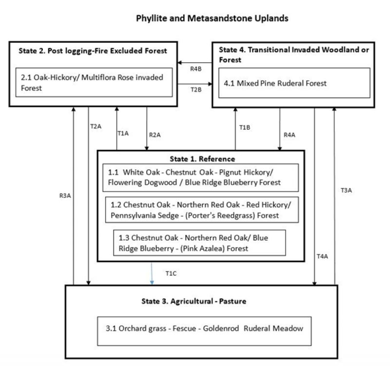
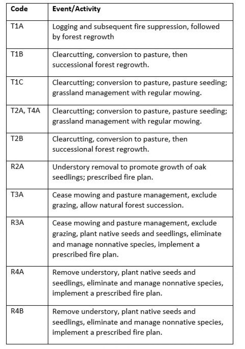
Click on box and path labels to scroll to the respective text.

