Natural Resources
Conservation Service
Ecological site F130BY012WV
Non-Hydric Floodplains
Last updated: 9/07/2018
Accessed: 02/07/2026
General information
Provisional. A provisional ecological site description has undergone quality control and quality assurance review. It contains a working state and transition model and enough information to identify the ecological site.
MLRA notes
Major Land Resource Area (MLRA): 130B–Southern Blue Ridge
This MLRA is in North Carolina (51 percent), Tennessee (18 percent), Georgia (17 percent), Virginia (10 percent), and South Carolina (4 percent). It makes up about 16,080 square miles (41,665 square kilometers). It is locally known as the Southern Appalachians. It includes Lenoir, Morganton, Marion, Hendersonville, Waynesville, and Asheville, North Carolina; Gatlinburg, Tennessee; Damascus and Galax, Virginia; Walhalla, South Carolina; and Cleveland, Dahlonega, and Ellijay, Georgia. Interstate 40 crosses the parts of the area in Tennessee and North Carolina. Interstate 77 crosses the part in Virginia. Many national forests are in the area, including the Jefferson, Cherokee, Nantahala, Pisgah, and Chattahoochee National Forests. The Appalachian Trail begins on Springer Mountain in Georgia, near Amicalola State Park. The Great Smoky Mountains National Park is in this MLRA. The Mount Rogers National Recreation Area is in the part of the MLRA in Virginia. The Cherokee Indian Reservation is west of Waynesville, North Carolina.
Classification relationships
This ecosite is found in mountians in MLRA 130B: Southern Blue Ridge
This is a complex system that encompasses a matrix of co-occurring vegetation communities. Data and maps produced by the SE GAP Analysis Project were queried (USGS 2001). At the most detailed level natural vegetation is represented by NatureServe's Ecological System classification (NatureServe 2017). Data has been cross-walked with NVC classification levels (Class, Subclass, Formation, Division, Macrogroup, Ecological System). The classification approach used was the International Terrestrial Ecological Systems Classification (ITESC) (NatureServe 2007 and White 2003). Ecological Systems were cross-checked with the Vegetation Classification System developed for the Great Smoky Mountains National Park (GRSM) in 2009.
Ecological site concept
About 80 percent of the acreage is cleared and used for pasture or cropland. The remainder is in woods. Wooded areas are mainly mixed hardwoods that include yellow-poplar, northern red oak, sycamore, black walnut, red maple, and hickories. Understory plants include rhododendron, ironwood, flowering dogwood, alder, greenbrier, and switchcane. Important crops grown are corn, tobacco, small grain, and vegetable crops. The soils included in this site concept are more well-drained than those in hydric floodplains and therefore differences in vegetation based on water tolerance is likely. This should be investigated in the field where future projects are identified. At the scale of PES, very little difference was discernable.
Associated sites
| F130BY011WV |
Hydric Floodplains |
|---|
Similar sites
| F130BY011WV |
Hydric Floodplains |
|---|
Table 1. Dominant plant species
| Tree |
Not specified |
|---|---|
| Shrub |
Not specified |
| Herbaceous |
Not specified |
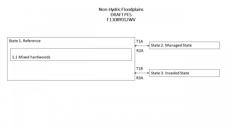
Click on box and path labels to scroll to the respective text.

