
Delta Plain - Frequently Flooded Ponded Very Poorly Drained Oxbows and Swales
List model
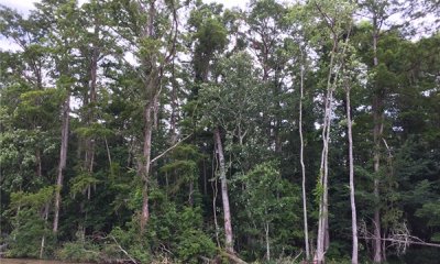
Historic Community Backswamp Hardwood
Open Canopy
Open Water Sparse Trees
New River Run & Floodplain
Converted State - Cropland
Converted State - Pasture or Grassland
Converted State - Urban development
Converted State - Woody Encroached
Scenario model
Current ecosystem state
Select a state
Management practices/drivers
Select a transition or restoration pathway
-
Transition T1A
Subsidence of soil surface or increased water depth.
More details -
Transition T*-4
Catastrophic event river change in channel location to new run.
More details -
Transition T1B
Build levees and install and maintain artificial drainage of site.
More details -
Transition T1B
Build levees and install and maintain artificial drainage of site.
More details -
Transition T1B
Build levees and install and maintain artificial drainage of site.
More details -
Transition T2A
Sediment accumulation or reduced water depth.
More details -
Transition T2B
Subsidence of soil surface or increased water depth.
More details -
Transition T*-4
Catastrophic event river change in channel location to new run.
More details -
Transition T3A
Sediment accumulation or reduced water depth.
More details -
Transition T*-4
Catastrophic event river change in channel location to new run.
More details -
Transition T4A
Channel change in path/ Reduced connection to main channel flow.
More details -
Transition T5A
Loss or removal of levees and artificial drainage system.
More details -
Transition T*-6
Establish desired forage species and manage for grazing.
More details -
Transition T*-7
Build homes, roads, and other urban infrastructure.
More details -
Transition T5A
Loss or removal of levees and artificial drainage system.
More details -
Transition T*-5
Establish and manage crop rotation.
More details -
Transition T*-7
Build homes, roads, and other urban infrastructure.
More details -
Transition T6A
Lack of disturbance: Natural growth succession of woody species.
More details -
Transition T5A
Loss or removal of levees and artificial drainage system.
More details -
Transition T5A
Loss or removal of levees and artificial drainage system.
More details -
No transition or restoration pathway between the selected states has been described
Target ecosystem state
Select a state
Description
Mixed Bottomland Hardwood - Baldcypress, Tupelo, Green Ash, Buttonbush
Submodel
Description
Open Canopy stand of cypress trees, marsh grasses, and open water.
Submodel
Description
Open water - Sparse trees and sparse herbaceous vegetation.
Submodel
Description
Catastrophic river change in channel (AVULSION)
When the river changes courses, which is caused by multiple factors, this site will be affected in potentially many ways. This site may become the location of the new channel when the river re-occupies and older course or that of another river. Conversely when the river changes course and abandons previous backswamps the site may lose sediment and water inputs and become drier, which will allow the fluid sediments to consolidate.. This State potentially has more phases compared to all other Ecological Site states in this sub region.
Submodel
Description
This site is generally considered not suited for crop production due to flooding and wetness. When the site hydrology has been altered mechanically by the construction of levees, water control structures, and potentially pumps, crop species may be established, and the site utilized for production. Maintenance of the hydrologic control must be continued to maintain production and if control is abandoned or lost, site conditions may return to excessively wet conditions which will prevent utilization of the land for crop production. Conditions even with control may only allow production on an irregular basis.
This state represents a crop production field. Annual plantings for forage production would also be included in this phase, which may include cool-season annual grasses and legumes and warm-season forage species. Vegetable crops are grown on this site and are generally on a small scale. Sugarcane, corn, and soybeans are dominant crops and can be planted in fields with adequate management. Wheat may be included in the rotation or as a standalone crop. Other row crop species have been produced on these sites. Often two or more crops will be grown in a multiyear rotation, this breaks pest cycles and some crops produce higher amounts of residue, which is left on the soil to improve soil health. Maintenance of monoculture crop stands also requires the control of unwanted species, which will require pest management and nutrient management to maintain the needed fertility for production of the desired species. Refer to E-Field Office Technical Guide (EFOTG) and the local NRCS Field Office for management assistance.
Submodel
Description
This site is generally considered not suited for grazing due to flooding and wetness. When the site hydrology has been altered mechanically by the construction of levees, water control structures, and potentially pumps, forage species may be established, and the site utilized for grazing. Maintenance of the hydrologic control must be continued to maintain production and if control is abandoned or lost, site conditions may return to excessively wet conditions which will prevent utilization of the land for forage production. Conditions even with control may only allow forage production on an irregular basis. Additionally, adjacent higher elevation areas or protected areas may be needed for the storage of harvested forage or holding of livestock when wet or flooded conditions occur. Some forage operations on this site may experience none to multiple extreme wetness events in a single year that will require preplanning and resources to meet the needs of the livestock.
This state is characterized by a monoculture or a mixture of forage species planted or allowed to establish from naturalized species managed for forage production or as herbaceous ground cover.
Submodel
Description
This site is generally considered not suited for urban development due to flooding and wetness. When the site hydrology has been altered mechanically by the construction of levees, water control structures and pumps development may be possible. Maintenance of the hydrologic control must be continued and if control is abandoned or lost, site conditions may return to excessively wet conditions which will inhibit urban development on this site.
This state represents an area that has been altered to provide locations for homes, businesses, and infrastructure where people live, work, and recreate. The human population is higher than in the surrounding rural area. It is where buildings are close together and are usually considered cities and towns. This state may be found in small clusters in rural areas where multiple buildings are in close proximity with roads and infrastructure that support a rural population.
The changes to the landscape will not generally return to the historic community of Hardwood trees, however, some of this landcover may be present in areas. There are generally many introduced species and potentially invasive species located in these areas and managed as ornamentals. These non-native species should be managed to prevent infestation and invasion into other areas where they can become a problem.
Within this land use, there are expansive networks of infrastructure both above and below ground for use by the inhabitants of the area. These include roads, drainage channels and structures, electrical distribution systems, telecommunications systems, drinking water distribution systems, and many other components that contribute to the quality of human life.
Submodel
Mechanism
Avulsion occurs when the river changes course to a new location. When this occurs, there are major changes to both locations on the landscape as well as the hydrologic regime. The transition will cause any given location to move into potentially any of the ecological site concepts which fit the sub-region of the MLRA.
Mechanism
Build levees and install and maintain artificial drainage of site.
Mechanism
Build levees and install and maintain artificial drainage of site.
Mechanism
Build levees and install and maintain artificial drainage of site.
Mechanism
Avulsion occurs when the river changes course to a new location. When this occurs, there are major changes to both locations on the landscape as well as the hydrologic regime. The transition will cause any given location to move into potentially any of the ecological site concepts which fit the sub-region of the MLRA.
Mechanism
Channel change in path. Reduced connection to main channel flow.
When a river channel is abandoned or reduced flow in the system, the Open Water Sparse Trees State begins to trap sediment and the transition pathway will turn towards the stable Backswamp Hardwoods state through the Open Canopy state.
Mechanism
Lack of disturbance: Natural growth succession of woody species.
Model keys
Briefcase
Add ecological sites and Major Land Resource Areas to your briefcase by clicking on the briefcase (![]() ) icon wherever it occurs. Drag and drop items to reorder. Cookies are used to store briefcase items between browsing sessions. Because of this, the number of items that can be added to your briefcase is limited, and briefcase items added on one device and browser cannot be accessed from another device or browser. Users who do not wish to place cookies on their devices should not use the briefcase tool. Briefcase cookies serve no other purpose than described here and are deleted whenever browsing history is cleared.
) icon wherever it occurs. Drag and drop items to reorder. Cookies are used to store briefcase items between browsing sessions. Because of this, the number of items that can be added to your briefcase is limited, and briefcase items added on one device and browser cannot be accessed from another device or browser. Users who do not wish to place cookies on their devices should not use the briefcase tool. Briefcase cookies serve no other purpose than described here and are deleted whenever browsing history is cleared.
Ecological sites
Major Land Resource Areas
The Ecosystem Dynamics Interpretive Tool is an information system framework developed by the USDA-ARS Jornada Experimental Range, USDA Natural Resources Conservation Service, and New Mexico State University.