
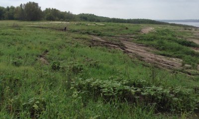
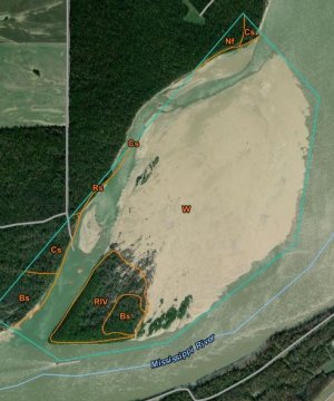
Batture - Frequently Flooded Pointbars, Sandbars, and Splays
Scenario model
Current ecosystem state
Select a state

Management practices/drivers
Select a transition or restoration pathway
-
Transition T 1-2
Wind or water force causing canopy gaps or removal of vegetation.
More details -
Transition T 1-3
Erosion or soil surface
More details -
Transition T 2-1
Regeneration of woody species.
More details -
Transition T 2-3
Erosion of Soil Surface
More details -
Transition T 3-2
Accumulation of sediment.
More details -
No transition or restoration pathway between the selected states has been described
Target ecosystem state
Select a state
Description
This state consists of forest canopy openings that are created by catastrophic disturbances, allowing sunlight to reach understory strata and ground surfaces. Depending on local conditions and disturbance regime and intensity, a continuum or range of successional stages and community structure (physiognomy) is represented. Provisionally, this state includes seral stages ranging from recent disturbances that consist mainly of sparse herbaceous cover over mostly bare soil to the regeneration of woody species among a dense herbaceous cover (early stand initiation stage) to the initial stem exclusion stage where woody growth overtops and shades out the herbaceous stratum. In future ecological site development efforts, multiple community phases that describe the composition and progression from one stage to the next may be warranted for specifying management strategies and actions.
Submodel
Mechanism
Wind or water force causing canopy gaps or removal of vegetation.
Mechanism
Wind or water force eroding soil surface removal of vegetation and allowing water to cover the soil, other than by normal river stages.
Mechanism
Erosion of soil surface allowing water to cover the soil, other than by normal river stages.
Model keys
Briefcase
Add ecological sites and Major Land Resource Areas to your briefcase by clicking on the briefcase (![]() ) icon wherever it occurs. Drag and drop items to reorder. Cookies are used to store briefcase items between browsing sessions. Because of this, the number of items that can be added to your briefcase is limited, and briefcase items added on one device and browser cannot be accessed from another device or browser. Users who do not wish to place cookies on their devices should not use the briefcase tool. Briefcase cookies serve no other purpose than described here and are deleted whenever browsing history is cleared.
) icon wherever it occurs. Drag and drop items to reorder. Cookies are used to store briefcase items between browsing sessions. Because of this, the number of items that can be added to your briefcase is limited, and briefcase items added on one device and browser cannot be accessed from another device or browser. Users who do not wish to place cookies on their devices should not use the briefcase tool. Briefcase cookies serve no other purpose than described here and are deleted whenever browsing history is cleared.
Ecological sites
Major Land Resource Areas
The Ecosystem Dynamics Interpretive Tool is an information system framework developed by the USDA-ARS Jornada Experimental Range, USDA Natural Resources Conservation Service, and New Mexico State University.