
Natural Resources
Conservation Service
Ecological site F131BY005AR
Wet Clay Bottomland
Last updated: 9/22/2023
Accessed: 04/02/2025
General information
Provisional. A provisional ecological site description has undergone quality control and quality assurance review. It contains a working state and transition model and enough information to identify the ecological site.

Figure 1. Mapped extent
Areas shown in blue indicate the maximum mapped extent of this ecological site. Other ecological sites likely occur within the highlighted areas. It is also possible for this ecological site to occur outside of highlighted areas if detailed soil survey has not been completed or recently updated.
MLRA notes
Major Land Resource Area (MLRA): 131B–Arkansas River Alluvium
Major Land Resource Area (MLRA) 131B, the Arkansas River Alluvium, is in Arkansas (67 percent) and Louisiana (33 percent). It makes up about 3,955 square miles. The towns of Montrose, Dumas, and England, Arkansas, and Monroe, Louisiana, are in this MLRA. Interstate 20 passes through Monroe, Louisiana. Most parts of the Overflow National Wildlife Refuge, the Upper Ouachita National Wildlife Refuge, and the D’Arbonne National Wildlife Area are in this MLRA.
Classification relationships
USDA-Natural Resources Conservation Service, 2006.
-Major Land Resource Area (MLRA) 131B
Ecological site concept
The ecological site has very deep, very poorly drained soils that are ponded throughout a portion of the year. A wetland plant community exists because it is the lowest position on the landscape, along with the flooding and ponding regimes.
Associated sites
F131BY006AR |
Clayey Flood Plain Site is not as wet and does not pond for as long. |
---|
Similar sites
F131CY004LA |
Wet Clay Bottomland Site is very similar, except in a different MLRA. |
---|
Table 1. Dominant plant species
Tree |
(1) Taxodium distichum |
---|---|
Shrub |
Not specified |
Herbaceous |
(1) Carex |
Physiographic features
These level to depressional soils are in backswamps, sloughs and abandon oxbows of the Arkansas River, Red River, and their tributaries. Slopes range form 0 to 1 percent. These soils are typically ponded with water, 0.5 to 5 feet, for 10 or more months in a normal year.
Table 2. Representative physiographic features
Landforms |
(1)
Alluvial plain
> Flood plain
(2) Alluvial plain > Backswamp |
---|---|
Runoff class | Negligible |
Flooding duration | Long (7 to 30 days) to very long (more than 30 days) |
Flooding frequency | Frequent |
Ponding duration | Long (7 to 30 days) to very long (more than 30 days) |
Ponding frequency | Frequent |
Elevation | 30 – 76 m |
Slope | 0 – 1% |
Ponding depth | 15 – 152 cm |
Water table depth | 0 cm |
Aspect | Aspect is not a significant factor |
Climatic features
The average annual precipitation is 56 inches, which increases from north to south. Most of the rainfall occurs as frontal storms during late fall, winter, and early spring, although an appreciable amount of precipitation also occurs as convective thunderstorms during the early part of the growing season. The total amount of the precipitation that occurs as snow ranges from less than one percent in the southern part of the MLRA to five percent in the northern part. Temperatures range from highs in the low 90's during the summer to lows in the low 30's during the winter. The frost-free period averages 222 days, while the freeze-free period averages 256 days.
Table 3. Representative climatic features
Frost-free period (average) | 222 days |
---|---|
Freeze-free period (average) | 256 days |
Precipitation total (average) | 1,422 mm |
Figure 2. Monthly precipitation range
Figure 3. Monthly average minimum and maximum temperature
Figure 4. Annual precipitation pattern
Figure 5. Annual average temperature pattern
Climate stations used
-
(1) DERMOTT 3 NE [USC00031962], Dermott, AR
-
(2) DUMAS [USC00032148], Dumas, AR
-
(3) PORTLAND [USC00035866], Portland, AR
-
(4) RAYVILLE [USC00167691], Rayville, LA
-
(5) MONROE ULM [USC00166314], Monroe, LA
-
(6) MONROE RGNL AP [USW00013942], Monroe, LA
-
(7) ROHWER 2 NNE [USC00036253], Pickens, AR
-
(8) COLUMBIA LOCK [USC00161979], Columbia, LA
-
(9) KEO [USC00033862], England, AR
-
(10) BASTROP [USC00160537], Bastrop, LA
Influencing water features
This site is influenced by proximity to backswamps, sloughs and abandon oxbows of the Arkansas River, Red River, and their tributaries. Sites are inundated from 0.5 to 5 feet up to 10 months in a normal year.
Wetland description
Soils associated with this site have a hydric soil rating. An on-site wetland determination is recommended.
Soil features
The Yorktown series consists of very deep, very poorly drained, very slowly permeable soils that formed in clayey alluvium. Only Yorktown is correlated to this ecological site. The taxonomic classification is a very-fine, smectitic, nonacid, thermic Vertic Epiaquept.
Table 4. Representative soil features
Parent material |
(1)
Alluvium
–
igneous and sedimentary rock
|
---|---|
Surface texture |
(1) Clay (2) Silty clay |
Family particle size |
(1) Clayey |
Drainage class | Very poorly drained |
Permeability class | Very slow |
Soil depth | 203 cm |
Surface fragment cover <=3" | 0% |
Surface fragment cover >3" | 0% |
Available water capacity (0-101.6cm) |
10.16 – 12.7 cm |
Calcium carbonate equivalent (0-101.6cm) |
0% |
Electrical conductivity (0-101.6cm) |
0 – 2 mmhos/cm |
Sodium adsorption ratio (0-101.6cm) |
0 |
Soil reaction (1:1 water) (0-101.6cm) |
5.6 – 8.4 |
Subsurface fragment volume <=3" (Depth not specified) |
0% |
Subsurface fragment volume >3" (Depth not specified) |
0% |
Ecological dynamics
The information in this ecological site description (ESD), including the state-and-transition model (STM), was developed using archeological and historical data, professional experience, and scientific studies. The information is representative of a complex set of plant communities. Not all scenarios or plants are included. Key indicator plants, animals, and ecological processes are described to inform land management decisions.
Introduction - This Arkansas River Alluvium (MLRA 131B) is on the alluvial plains along the lower Arkansas River in Arkansas and the Ouachita River in Louisiana and Arkansas. The landforms in the area are level or depressional to very gently undulating alluvial plains, backswamps, oxbows, natural levees, and terraces. Landform shapes range from convex on natural levees and undulating terraces, to concave in oxbows. Landform shapes differentiate water-shedding positions from water-receiving positions, both of which affect soil formation and hydrology. Average elevations start at about 50 feet in the southern part of the area and gradually rise to about 250 feet in the northwestern part. Maximum local relief is about 10 feet, but relief is considerably lower in most of the area.
Geology - Bedrock in this area consists of Tertiary and Cretaceous sands formed as beach deposits during the retreat of the Cretaceous ocean from the midsection of the United States. Alluvial deposits from flooding and lateral migration of the Arkansas and Ouachita Rivers typically lie above the bedrock. These sediments are sandy to clayey fluvial deposits of Holocene to late Pleistocene age and are many feet thick. The geologic surfaces are identified as the Arkansas Lowlands, which extend from the Yazoo Basin up the Arkansas River to the margin of the Coastal Plain, and the parts of the Tensas Basin west of Macon Ridge. The deposits on both of these surfaces are of Holocene age. In some areas late Pleistocene terrace deposits are within several feet of the present surfaces, but they do not crop out in the MLRA.
Biological Resources - This area once consisted entirely of bottomland hardwood deciduous forest and mixed hardwood and cypress swamps pocked with areas of prairies on the terraces. The major tree species in the native plant communities in the areas of bottomland hardwoods formerly were and currently are water oak (Quercus nigra), Nuttall oak (Quercus texana), cherrybark oak (Quercus pagoda), pecan (Carya illinoensis), red maple (Acer rubrum), sweetgum (Liquidambar styraciflua), eastern cottonwood (Populus deltoides), and hickory (Carya sp.). The major tree species in the native plant communities in the swamps formerly were and currently are bald cypress (Taxodium distichum), water tupelo (Nyssa aquatica), green ash (Fraxinus pennsylvanica), and black willow (Salix nigra). The important native understory species are palmetto (Sabal minor), greenbrier (Smilax sp.), wild grape (Vitis sp.), and poison ivy (Toxicodendron radicans) in the areas of bottomland hardwoods and buttonbush (Cephalanthus occidentalis), lizardtail (Saururus cernuus), waterlily (Nymphaea sp.), sedges (Carex sp.), and rushes (Juncus sp.) in the swamps. Switchgrass (Panicum virgatum), big bluestem (Andropogon gerardii), little bluesetm (Schizachyrium scoparium), Indiangrass (Sorghastrum nutans), and eastern gamagrass (Tripsacum dactyloides) vegetate the prairie terraces.
Land Use - Land use varies throughout the MLRA consisting of 80 percent cropland, 2 percent grassland, 10 percent forest, 6 percent water, and 2 percent other. Wildlife and waterfowl habitat and forested wetlands make up nearly all of this area. Wildlife (Squirrels, Rabbits, Whitetail deer, and Migratory waterfowl are harvested throughout the area. Hardwood timber is harvested on some forested wetlands, and most forested areas are managed for wildlife.
Conservation - The major resource concerns are flood control, water quality, management of soil moisture, and maintenance of the content of organic matter and productivity of the soils. Conservation practices for wildlife and waterfowl habitat generally include creating brush piles for resting/escape cover and den sites for small mammals and birds. Control of invasive species. Leaving varying size snags, dead or partially dead standing trees provide cavities for nesting and resting, perches for hunting and displaying, and an abundant supply of food for insect eaters. Establishing permanent vegetation for wildlife. Provide
nesting boxes or other structures where natural nest sites (particularly cavities) are available in low numbers.
State and transition model

Figure 6. STM
More interactive model formats are also available.
View Interactive Models
More interactive model formats are also available.
View Interactive Models
Click on state and transition labels to scroll to the respective text
Ecosystem states
State 1 submodel, plant communities
State 2 submodel, plant communities
State 1
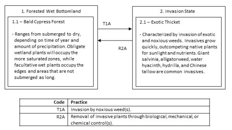
Forested Wet Bottomland
The ecological site is a Bald Cypress Forest. The dominant force in shaping the vegetation is the semi-permanent inundation of water. The hydrology does not allow oxygen to flow through the soil, causing anoxic conditions. Some soil indicators include: gleyed (grey) colors with redoximorphic features (reds and yellow intermixed) and the smell of rotten eggs when disturbed (release of hydrogen-sulfide gases). Bald cypress have adapted to the conditions and are the dominant as the overstory tree with water tupelo. Cypress “knees” can usually be found emerging from the soil as an adaption to saturated soil conditions.
Community 1.1
Bald Cypress Forest
The vegetation that has adapted to the anaerobic conditions are dominant. The United State Army Corps of Engineers (USACOE) classifies plants that occur in wetlands with an estimated probability greater than 99 percent obligate (OBL), and those 67 to 99 percent facultative wetland (FACW) plants. Obligate and facultative wetland plants are the most common encountered throughout the Swamps. When submerged, indicator species include coon’s tail (Ceratophyllum demersum) and duckweeds (Azolla sp., Lemna sp., and Wolffia sp.). When the conditions are drier, or more near the periphery, indicator species are swamp smartweed (Polygonum hydropiperoides), marsh seedbox (Ludwigia palustris), and various sedges (Carex sp. and Cyperus sp.).
State 2
Invasion
Giant salvinia (Salvinia molesta) is a small free-floating plant native to South America. It is rapidly growing and able to double in size every 4 to 10 days under good conditions. Colonies that cover the surface cut off light to native plants and can cause oxygen depletions. The depletions are detrimental to an already low-oxygen environment. Further, decomposition of dead salvinia in the water column can further deplete oxygen levels, causing fish kills. Salvinia has no known direct food value to native wildlife.
Community 2.1
Exotic Thicket
Other aquatic pests include alligatorweed (Alternanthera philoxeroides), water hyacinth (Eichhornia crassipes), hydrilla (Hydrilla sp.), and Chinese tallow (Triadica sebifera). As with salvinia, these noxious weeds out-compete the native plants. They lack natural control and upset the balance of the natural environment. Control of noxious weeds often proves difficult, expending great amounts of energy. Research, federal, and state agencies have devoted a great deal of time in developing management options for the control of these species.
Transition T1A
State 1 to 2
The transition from the State 1 to State 2 is a result of occupancy by noxious weeds. Invasion can be enhanced by clearing of the overstory. Invasive plants outcompete, and eventually choke out, all other native species.
Restoration pathway R2A
State 2 to 1
The driver for restoration is removal of the noxious invasives. Control of the many aquatic invasives is difficult, requiring great effort. Mechanical options include seining or raking, but the plants will reestablish from any remaining fragments. Biological controls include using triploid grass carp. Permits are required before usage and may be purchased through certified dealers. Salvinia weevils (Cyrtobagous salvinae) have also been used for control. They are natural predators and feed only on salvinia. Biological controls will not completely eradicate invasives, but have proven beneficial in some circumstances. Several chemicals methods are available, including diquat, fluridone, glyphosate, penoxsalum, and flumioxazin. Some aquatic herbicides have water use restrictions and can potentially affect non-target species, so labels and restrictions should be studied prior to application. Careful understanding of consequences is necessary before application of any control method.
Additional community tables
Interpretations
Supporting information
Inventory data references
This site description was developed as part of the provisional ecological site initiative using historic soil survey manuscripts, available range site descriptions, and low intensity field sampling.
Other references
Allen, J. A., B. D. Keeland, J. A. Stanturf, and A. F. Kennedy Jr. 2001. A guide to bottomland hardwood restoration. Technical report, USGS/BRD/ITR-2000-0011.
Louisiana Natural Heritage Program. 2009. The Natural Communities of Louisiana. Baton Rouge, LA, U.S.A. Data current as of August 2009.
NatureServe. 2013. International Ecological Classification Standard: Terrestrial Ecological Classifications. NatureServe Central Databases. Arlington, VA, U.S.A. Data current as of 12 July 2013.
Randall, J. M., and J. Marinelli. 1996. Invasive plants: weeds of the global garden. Volume 149. Brooklyn Botanic Garden, Brooklyn, NY.
Soil Survey Staff, Natural Resources Conservation Service, United States Department of Agriculture. Soil Survey Geographic (SSURGO) Database.
Stanturf, J. A., S. H. Schoenholtz, C. J. Schweitzer, and J. P. Shepard. 2001. Achieving restoration success: Myths in bottomland hardwood forests. Restoration Ecology, 9:189-200.
Stringham, T. K., W. C. Krueger, and P. L. Shaver. 2003. State and transition modeling: An ecological process approach. Journal of Range Management 56:106-113.
U.S. Army Corps of Engineers. 2010. Regional supplement to the Corps of Engineers Wetland Delineation Manual: Atlantic and Gulf Coastal Plain Region (Version 2.0). U.S. Army Corps of Engineers, Engineer Research and Development Center, Environmental Laboratory ERDC/EL TR-10-20.
USDA-NRCS Ag Handbook 296 (2006).
Contributors
Tyson Hart
Marc Bordelon
Approval
Bryan Christensen, 9/22/2023
Rangeland health reference sheet
Interpreting Indicators of Rangeland Health is a qualitative assessment protocol used to determine ecosystem condition based on benchmark characteristics described in the Reference Sheet. A suite of 17 (or more) indicators are typically considered in an assessment. The ecological site(s) representative of an assessment location must be known prior to applying the protocol and must be verified based on soils and climate. Current plant community cannot be used to identify the ecological site.
Author(s)/participant(s) | |
---|---|
Contact for lead author | |
Date | 11/08/2021 |
Approved by | Bryan Christensen |
Approval date | |
Composition (Indicators 10 and 12) based on | Annual Production |
Indicators
-
Number and extent of rills:
-
Presence of water flow patterns:
-
Number and height of erosional pedestals or terracettes:
-
Bare ground from Ecological Site Description or other studies (rock, litter, lichen, moss, plant canopy are not bare ground):
-
Number of gullies and erosion associated with gullies:
-
Extent of wind scoured, blowouts and/or depositional areas:
-
Amount of litter movement (describe size and distance expected to travel):
-
Soil surface (top few mm) resistance to erosion (stability values are averages - most sites will show a range of values):
-
Soil surface structure and SOM content (include type of structure and A-horizon color and thickness):
-
Effect of community phase composition (relative proportion of different functional groups) and spatial distribution on infiltration and runoff:
-
Presence and thickness of compaction layer (usually none; describe soil profile features which may be mistaken for compaction on this site):
-
Functional/Structural Groups (list in order of descending dominance by above-ground annual-production or live foliar cover using symbols: >>, >, = to indicate much greater than, greater than, and equal to):
Dominant:
Sub-dominant:
Other:
Additional:
-
Amount of plant mortality and decadence (include which functional groups are expected to show mortality or decadence):
-
Average percent litter cover (%) and depth ( in):
-
Expected annual annual-production (this is TOTAL above-ground annual-production, not just forage annual-production):
-
Potential invasive (including noxious) species (native and non-native). List species which BOTH characterize degraded states and have the potential to become a dominant or co-dominant species on the ecological site if their future establishment and growth is not actively controlled by management interventions. Species that become dominant for only one to several years (e.g., short-term response to drought or wildfire) are not invasive plants. Note that unlike other indicators, we are describing what is NOT expected in the reference state for the ecological site:
-
Perennial plant reproductive capability:
Print Options
Sections
Font
Other
The Ecosystem Dynamics Interpretive Tool is an information system framework developed by the USDA-ARS Jornada Experimental Range, USDA Natural Resources Conservation Service, and New Mexico State University.
Click on box and path labels to scroll to the respective text.