Ecological dynamics
The information in this ecological site description (ESD), including the state-and-transition model (STM), was developed using archeological and historical data, professional experience, and scientific studies. The information is representative of a complex set of plant communities. Not all scenarios or plants are included. Key indicator plants, animals, and ecological processes are described to inform land management decisions.
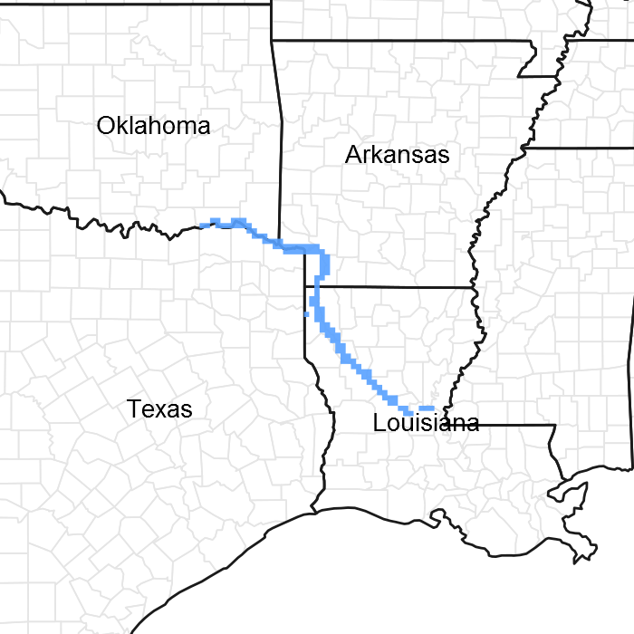
Introduction - Almost all of the Red River Alluvium (MLRA 131C) is in the West Gulf Coastal Plain Section of the Coastal Plain Province of the Atlantic Plain. The southern end is in the Mississippi Alluvial Plain Section of the same province and division. The landforms in the area are level or depressional to very gently undulating alluvial plains, backswamps, oxbows, natural levees, and terraces. Landform shapes range from convex on natural levees and undulating terraces to concave in oxbows. Landform shapes differentiate water-shedding positions from water-receiving positions, both of which have a major effect on soil formation and hydrology. Average elevations start at about 40 feet in the southern part of the area and gradually rise to about 270 feet in the northwestern part. Maximum local relief is about 10 feet, but relief is considerably lower in most of the area.
Geology - Bedrock in this area consists of Tertiary and Cretaceous sands formed as beach deposits during the retreat of the Cretaceous ocean from the midsection of the United States. Alluvial deposits from flooding and lateral migration of the Red River typically lie above the bedrock. These sediments are sandy to clayey fluvial deposits of Holocene to late Pleistocene age and are many feet thick. In some areas late Pleistocene terrace deposits are within several feet of the present surfaces, but they do not crop out in this MLRA. The geologic history of the area is greatly influenced by a large logjam that formed in the Red River channel in the middle part of the area during the late 18th century and the early 19th century. At the time of its largest extent, the logjam obstructed the river and its tributary outlets for a distance of 160 miles downstream from the Arkansas state boundary. Backwater flooding, reformation of natural levees, and crevasse splays caused by this logjam played a major role in covering large parts of the area with a mantle of recent clayey to sandy material. Destruction of the logjam in the late 1800's resulted in the drainage of many large lakes that had formed.
Biological Resources - This area once consisted entirely of bottomland hardwood deciduous forest and mixed hardwood and cypress swamps. The major tree species in the native plant communities in the areas of bottomland hardwoods formerly were and currently are water oak (Quercus nigra), Nuttall oak (Quercus texana), cherrybark oak (Quercus pagoda), pecan (Carya illinoensis), red maple (Acer rubrum), sweetgum (Liquidambar styraciflua), eastern cottonwood (Populus deltoides), and hickory (Cary sp.). The major tree species in the native plant communities in the swamps formerly were and currently are bald cypress (Taxodium distichum), water tupelo (Nyssa aquatica), green ash (Fraxinus pennsylvanica), and black willow (Salix nigra). The important native understory species are palmetto (Sabal minor), greenbrier (Smilax sp.), wild grape (Vitis sp.), and poison ivy (Toxicodendron radicans) in the areas of bottomland hardwoods and buttonbush (Cephalanthus occidentalis), lizardtail (Saururus cernuus), waterlily (Nymphaea sp.), sedges (Carex sp.), and rushes (Juncus sp.) in the swamps.
Land use - Land use varies throughout the MLRA, consisting of 37 percent cropland, 20 percent grassland, 31 percent forest, 5 percent urban development, 5 percent water, and 2 percent other. Farms and scattered tracts of forested wetlands make up nearly all of this area. The farms produce mainly cash crops. Cotton, soybeans, milo, and corn are the main crops. Sugarcane is a major crop in the southernmost part of the area. In many areas furrow irrigation is used during droughty parts of the growing season. Throughout the area, catfish are produced commercially on farm ponds that are contained by levees. Migratory waterfowl are harvested throughout the area. Hardwood timber is harvested on some forested wetlands, and most forested areas are managed for wildlife.
Conservation - The major resource concerns are control of surface water, management of soil moisture, and maintenance of the content of organic matter and productivity of the soils. Conservation practices on cropland generally include nutrient management, crop residue management, and alternative tillage systems, especially no-till systems. In many areas land leveling or shaping optimizes the control of surface water. Other major cropland management practices are control of competing vegetation and insects through aerial or ground spraying of herbicides and insecticides and fertility management programs that make use of chemical fertilizers.
State 1
Forest
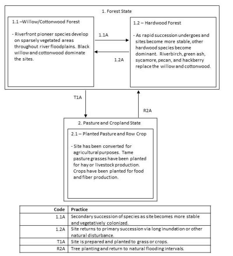
The Sandy Floodplain is a rapidly-changing state due to its proximity to rivers and streams. Sands and silts are dumped each time the area floods, as evidenced in the soil's weakly formed horizons. The Forest State has two communities, the 1.1 Willow/Cottonwood Forest Community and the 1.2 Hardwood Forest Community.
Community 1.1
Willow/Cottonwood Forest
The Willow/Cottonwood Forest Community represents primary succession and the earliest vegetative colonization of newly formed point bars and splays. Black willow (Salix nigra) is the immediate colonizer, while cottonwood (Populus deltoides) is a secondary associate. The willows will eventually give way as cottonwoods age and secondary colonizers arrive.
Community 1.2
Hardwood Forest
After the initial colonization by willows and cottonwood, many other hardwoods take root. Cottonwood will remain the primary associate, but consociates include: riverbirch (Betula nigra), green ash, American sycamore (Platanus occidentalis), pecan, hackberry (Celtis laevigata), red maple, swamp privet (Forestiera acuminate), water elm (Planera aquatic), and American elm (Ulmus Americana). The successional sequence largely relies on river and stream meandering. As soils are deposited and removed, the community moves back and forth between 1.1 and 1.2.
Pathway 1.1A
Community 1.1 to 1.2
Secondary succession occurs as willow and cottonwood are replaced by hardwoods. The 1.1 vegetative community stabilizes the site and provides good growing conditions for the community 1.2 plants.
Pathway 1.2A
Community 1.2 to 1.1
Rivers and streams can shift or meander and remove or dump new sediments. These sandy sites have loose horizons and large floods can remove all vegetation. Site returns to community 1.1 by long inundation by flooding or other natural disturbance.
State 2
Pasture and Cropland
The Pasture and Cropland State is a result of conversion activities. The landowner has maximized agriculture production by planting a monoculture of introduced grass species or agricultural row crops.
Community 2.1
Planted Pasture and Row Crop
Typical perennial warm-season grasses include Bermudagrass, bahiagrass, dallisgrass, and Johnsongrass. Spring and fall forages may include legumes such as clover. The grasses are grown for livestock production through direct grazing or baling hay for later use. Agricultural row crops are grown for food and fiber production. Typical crops include cotton, soybeans, milo, corn, rice, and sugarcane. Many farmers use herbicides to reduce unwanted plant competition which yields a plant community unrepresentative of State 1 or subsequent vegetative states.
Transition T1A
State 1 to 2
The transition is due to the land manager maximizing agricultural production. If present, merchantable timber is harvested by clearcut, then the site is prepared and planted to either a tame grass or row crop.
Restoration pathway R2A
State 2 to 1
This restoration path can be accomplished by planting a mix of native species to their natural frequencies. Management will be required to control unwanted species by burning, mowing, and/or herbicides. Controlling introduced pasture grasses is difficult, with complete control likely not attainable. The herbaceous understory will take time to develop, but this process can be expedited if adapted plant material seed is available.


