Ecological dynamics
The information in this ecological site description (ESD), including the state-and-transition model (STM), was developed using archeological and historical data, professional experience, and scientific studies. The information is representative of a complex set of plant communities. Not all scenarios or plants are included. Key indicator plants, animals, and ecological processes are described to inform land management decisions.
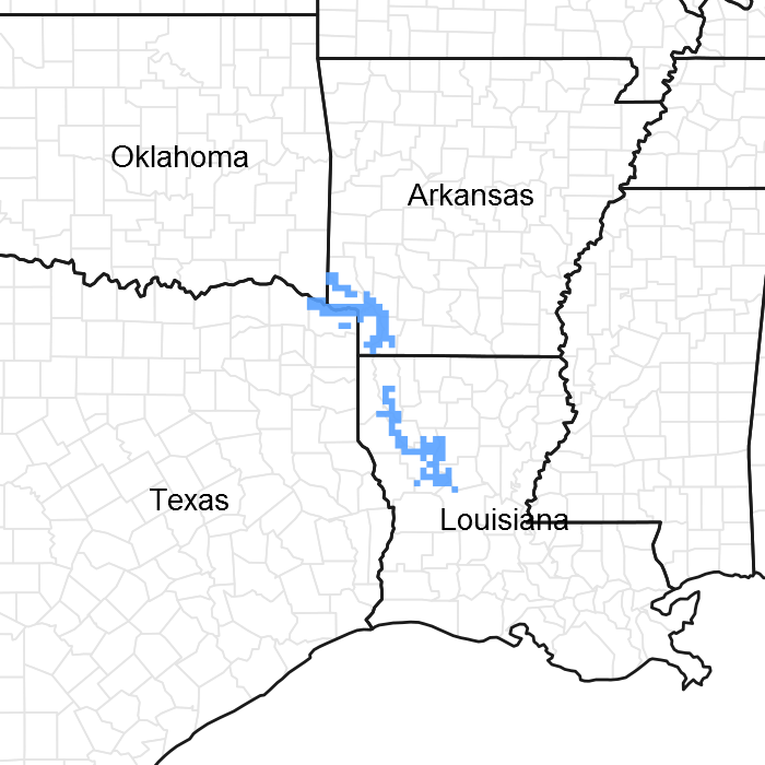
Introduction - Almost all of the Red River Alluvium (MLRA 131C) is in the West Gulf Coastal Plain Section of the Coastal Plain Province of the Atlantic Plain. The southern end is in the Mississippi Alluvial Plain Section of the same province and division. The landforms in the area are level or depressional to very gently undulating alluvial plains, backswamps, oxbows, natural levees, and terraces. Landform shapes range from convex on natural levees and undulating terraces to concave in oxbows. Landform shapes differentiate water-shedding positions from water-receiving positions, both of which have a major effect on soil formation and hydrology. Average elevations start at about 40 feet in the southern part of the area and gradually rise to about 270 feet in the northwestern part. Maximum local relief is about 10 feet, but relief is considerably lower in most of the area.
Geology - Bedrock in this area consists of Tertiary and Cretaceous sands formed as beach deposits during the retreat of the Cretaceous ocean from the midsection of the United States. Alluvial deposits from flooding and lateral migration of the Red River typically lie above the bedrock. These sediments are sandy to clayey fluvial deposits of Holocene to late Pleistocene age and are many feet thick. In some areas late Pleistocene terrace deposits are within several feet of the present surfaces, but they do not crop out in this MLRA. The geologic history of the area is greatly influenced by a large logjam that formed in the Red River channel in the middle part of the area during the late 18th century and the early 19th century. At the time of its largest extent, the logjam obstructed the river and its tributary outlets for a distance of 160 miles downstream from the Arkansas state boundary. Backwater flooding, reformation of natural levees, and crevasse splays caused by this logjam played a major role in covering large parts of the area with a mantle of recent clayey to sandy material. Destruction of the logjam in the late 1800's resulted in the drainage of many large lakes that had formed.
Biological Resources - This area once consisted entirely of bottomland hardwood deciduous forest and mixed hardwood and cypress swamps. The major tree species in the native plant communities in the areas of bottomland hardwoods formerly were and currently are water oak (Quercus nigra), Nuttall oak (Quercus texana), cherrybark oak (Quercus pagoda), pecan (Carya illinoensis), red maple (Acer rubrum), sweetgum (Liquidambar styraciflua), eastern cottonwood (Populus deltoides), and hickory (Cary sp.). The major tree species in the native plant communities in the swamps formerly were and currently are bald cypress (Taxodium distichum), water tupelo (Nyssa aquatica), green ash (Fraxinus pennsylvanica), and black willow (Salix nigra). The important native understory species are palmetto (Sabal minor), greenbrier (Smilax sp.), wild grape (Vitis sp.), and poison ivy (Toxicodendron radicans) in the areas of bottomland hardwoods and buttonbush (Cephalanthus occidentalis), lizardtail (Saururus cernuus), waterlily (Nymphaea sp.), sedges (Carex sp.), and rushes (Juncus sp.) in the swamps.
Land use - Land use varies throughout the MLRA, consisting of 78 percent wildlife and waterfowl habitat, 10 percent forest, 10 percent water, and 2 percent other. Scattered tracts of forested wetlands make up nearly all of this area. Migratory waterfowl are harvested throughout the area. Hardwood timber is harvested on some forested wetlands, and most forested areas are managed for wildlife and waterfowl. Throughout the area, catfish are produced commercially on farm ponds that are contained by levees.
Conservation - The major resource concerns are control of surface water and water quality. Conservation practices in wildlife and waterfowl habitat is water quality, wildlife species enhancement, and encroachment of invasive plant species. Other major wildlife management practices are control of competing vegetation, maintaining wildlife and song bird buffers which provide cover and feeding areas for small game animals and birds. Introduction of pollinator areas.
State 1
Forested Wet Bottomland
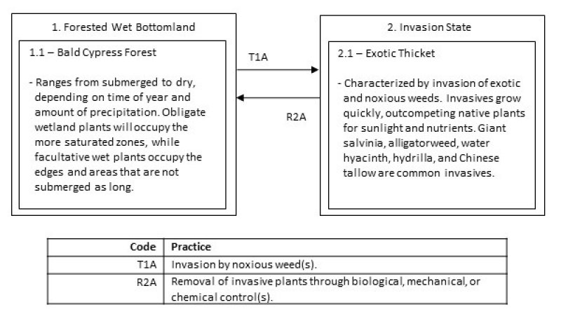
The ecological site is a Bald Cypress Forest. The dominant force in shaping the vegetation is the semi-permanent inundation of water. The hydrology does not allow oxygen to flow through the soil, causing anoxic conditions. Some soil indicators include: gleyed (grey) colors with redoximorphic features (reds and yellow intermixed) and the smell of rotten eggs when disturbed (release of hydrogen-sulfide gases). Bald cypress have adapted to the conditions and are the dominant as the overstory tree with water tupelo. Cypress “knees” can usually be found emerging from the soil as an adaption to saturated soil conditions.
Community 1.1
Bald Cypress Forest
The vegetation that has adapted to the anaerobic conditions are dominant. The United State Army Corps of Engineers (USACOE) classifies plants that occur in wetlands with an estimated probability greater than 99 percent obligate (OBL), and those 67 to 99 percent facultative wetland (FACW) plants. Obligate and facultative wetland plants are the most common encountered throughout the Swamps. When submerged, indicator species include coon’s tail (Ceratophyllum demersum) and duckweeds (Azolla sp., Lemna sp., and Wolffia sp.). When the conditions are drier, or more near the periphery, indicator species are swamp smartweed (Polygonum hydropiperoides), marsh seedbox (Ludwigia palustris), and various sedges (Carex sp. and Cyperus sp.).
State 2
Invasion
Giant salvinia (Salvinia molesta) is a small free-floating plant native to South America. It is rapidly growing and able to double in size every 4 to 10 days under good conditions. Colonies that cover the surface cut off light to native plants and can cause oxygen depletions. The depletions are detrimental to an already low-oxygen environment. Further, decomposition of dead salvinia in the water column can further deplete oxygen levels, causing fish kills. Salvinia has no known direct food value to native wildlife.
Community 2.1
Exotic Thicket
Other aquatic pests include alligatorweed (Alternanthera philoxeroides), water hyacinth (Eichhornia crassipes), hydrilla (Hydrilla sp.), and Chinese tallow (Triadica sebifera). As with salvinia, these noxious weeds out-compete the native plants. They lack natural control and upset the balance of the natural environment. Control of noxious weeds often proves difficult, expending great amounts of energy. Research, federal, and state agencies have devoted a great deal of time in developing management options for the control of these species.
Transition T1A
State 1 to 2
The transition from the State 1 to State 2 is a result of occupancy by noxious weeds. Invasion can be enhanced by clearing of the overstory. Invasive plants outcompete, and eventually choke out, all other native species.
Restoration pathway R2A
State 2 to 1
The driver for restoration is removal of the noxious invasives. Control of the many aquatic invasives is difficult, requiring great effort. Mechanical options include seining or raking, but the plants will reestablish from any remaining fragments.
Biological controls include using triploid grass carp. Permits are required before usage and may be purchased through certified dealers. Salvinia weevils (Cyrtobagous salvinae) have also been used for control. They are natural predators and feed only on salvinia. Biological controls will not completely eradicate invasives, but have proven beneficial in some circumstances.
Several chemicals methods are available, including diquat, fluridone, glyphosate, penoxsalum, and flumioxazin. Some aquatic herbicides have water use restrictions and can potentially affect non-target species, so labels and restrictions should be studied prior to application. Careful understanding of consequences is necessary before application of any control method.


