Natural Resources
Conservation Service
Ecological site F133AY003NC
Atlantic Coastal Plain Small Brownwater River Floodplain - PROVISIONAL
Accessed: 02/09/2026
General information
Provisional. A provisional ecological site description has undergone quality control and quality assurance review. It contains a working state and transition model and enough information to identify the ecological site.
MLRA notes
Major Land Resource Area (MLRA): 133A–Southern Coastal Plain
This MLRA (shown in orange in the figure above) is in Alabama (26 percent), Mississippi (24 percent), Georgia (21 percent), Florida (8 percent), North Carolina (7 percent), Virginia (5 percent), South Carolina (4 percent), Tennessee (4 percent), and Louisiana (1 percent). It makes up about 106,485 square miles (275,930 square kilometers). It is the largest MLRA in the U.S. The city of Alexandria, Virginia, is at the northernmost tip of the area. The MLRA also includes Fredericksburg, Richmond, and Petersburg, Virginia; Rocky Mount, Goldsboro, Fayetteville, and Lumberton, North Carolina; Florence, Sumter, and Orangeburg, South Carolina; Albany and Tifton, Georgia; Tallahassee, Florida; Tuskegee, Eufaula, Selma, and Tuscaloosa, Alabama; Savannah, Tennessee; Corinth, Starkville, Grenada, Meridian, Hattiesburg, and McComb, Mississippi; and Bogalusa, Louisiana. Interstates 95, 64, 85, 40, 20, 20/59, 26, 16, 75, 10, 65, 59, and 55 cross this area from north to south. This area extends from Virginia to Louisiana and Mississippi, but it is almost entirely within three sections of the Coastal Plain Province of the Atlantic Plain. The northern part is in the Embayed Section, the middle part is in the Sea Island Section, and the southern part is in the East Gulf Coastal Plain Section. This MLRA is strongly dissected into nearly level and gently undulating valleys and gently sloping to steep uplands. Stream valleys generally are narrow in their upper reaches but become broad and have widely meandering stream channels as they approach the coast. Elevation ranges from 80 to 655 feet (25 to 200 meters), increasing gradually from the lower Coastal Plain northward. Local relief is mainly 10 to 20 feet (3 to 6 meters), but it is 80 to 165 feet (25 to 50 meters) in some of the more deeply dissected areas.
Classification relationships
ATTENTION: This ecological site meets the requirements for PROVISIONAL. A provisional ecological site is established after ecological site concepts are developed and an initial state-and-transition model is drafted. A provisional ecological site typically will include literature reviews, land use history information, legacy data, and must include some soils data, ocular estimates for canopy and/or species composition by weight, and some line-point intercept information. A provisional ecological site provides the conceptual framework of soil-site correlation for the development of the ESD. For more information about this ecological site, please contact your local NRCS office.
Ecological site concept
This system encompasses the floodplains of small to medium brownwater rivers of the Atlantic Coastal Plain which are intermediate between the smaller streams and the largest rivers. Brownwater rivers originate in clayey areas and carry substantial amounts of mineral sediment, creating well-developed deposition alluvial landforms and fertile soils. Vegetation is a mosaic of cypress and gum swamps, oak-dominated bottomland hardwoods, and mixed levee forests, with only local non-forested communities. Occurs in floodplains of medium to small Coastal Plain rivers that carry significant mineral sediment (brownwater or redwater rivers). These rivers have their headwaters in the Piedmont, Blue Ridge, Interior Plateaus, or in portions of the Coastal Plain where fine-textured sediment predominates. The water generally carries substantial amounts of silt, clay, and sometimes sand.
Depositional landforms such as point bars, natural levees, backswamps, and ridge-and-swale systems (scrollwork) are well-developed and form patterns of significant variation in flooding duration and nutrient input. Soil texture varies from sandy to clayey. Soils are generally fertile and not strongly acidic. Flooding ranges from semipermanent in the wettest areas to intermittent and short on the higher portions of the floodplain. The highest terraces may no longer flood at all and belong to a different system. Descriptions of Ecological Systems for
Modeling of LANDFIRE Biophysical Settings
Ecological Systems
06 October 2007
Descriptions provided to TNC and LANDFIRE by NatureServe
Table 1. Dominant plant species
| Tree |
(1) Taxodium distichum |
|---|---|
| Shrub |
(1) Betula nigra |
| Herbaceous |
(1) Boehmeria cylindrica |
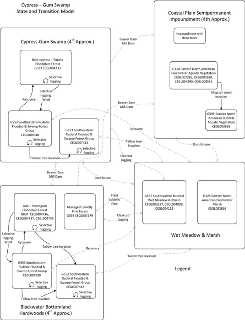
Click on box and path labels to scroll to the respective text.
