
Shallow to Moderately Deep Well Drained Silty Clay to Clay Alkaline Broad Flats
Scenario model
Current ecosystem state
Select a state
Management practices/drivers
Select a transition or restoration pathway
-
Transition T1-2
Leave undisturbed
More details -
Transition T1-3
Manage for pasture
More details -
Transition T1-4
Manage for crops
More details -
Transition T2-3
Clear and manage pasture
More details -
Transition T2-4
Manage for crops
More details -
Transition T2-5
Manage for native prairie
More details -
Transition T3-2
Leave unmanaged
More details -
Transition T3-4
Manage for crops
More details -
Transition T3-5
Manage for native prairie
More details -
Transition T3-6
Management practices degrade the soil
More details -
Transition T4-3
Manage for pasture
More details -
Transition T4-5
Manage for native prairie
More details -
Transition T4-6
Management practices degrade the soil
More details -
Transition T5-2
There is not enough disturbance to maintain a prairie
More details -
Transition T5-3
Manage for pasture
More details -
Transition T5-4
Manage for crops
More details -
Transition T6-2
Measures are taken to prevent erosion and redcedar might be able to be established
More details -
No transition or restoration pathway between the selected states has been described
Target ecosystem state
Select a state
Description
This ecological state can be broadly defined as any mixed species grassland (potentially with a few trees) on thin calcareous uplands that have not been modified for pasture, hay production, or cropland. Evidence suggests that this ecological state initially occurred as a result of rotational burning done by the Native American Tribes in the region. Native grasslands were described by many of the early explorers of this region; however, they are seldom, if ever, seen in pristine condition in modern times. Most remnants of the native grasslands occur in small patches between 1-10 acres, and almost all of these remnants now contain non-native and invasive species. Anthropogenic effects, such as changes in land management, introduction of non-native species, and soil erosion, have all led to the degradation and diminishing representation of this ecological state.
Characteristics and indicators
This state is characterized by a mixture of grasses, forbs, sedges, and other herbaceous plants with relatively few trees. Additionally, there may be areas of exposed chalk where there is little to no plant life.
Resilience management
This ecological state requires regular disturbance to be maintained. This disturbance predominantly occurs as burning or mowing. If an area growing as a native grassland is not being managed it will transition into a redcedar forest over time.
Submodel
Description
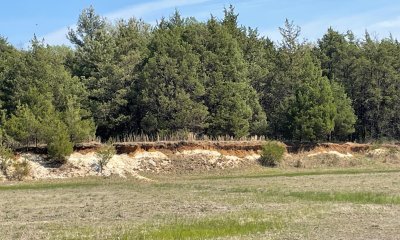
This ecological state is commonly seen adjacent to cropland and pasture, and it frequently occurs on steeper areas and along property lines, areas that are less likely to be disturbed by agricultural processes. Historic documentation indicates that wooded thickets used to be comprised of species such as Chickasaw plum (Prunus angustifolia), hawthorns (Crataegus engelmannii), and crab apple (Malus angustifolia). Furthermore, these records indicate that prior to European settlement there was very little eastern redcedar (Juniperus virginiana) on these sites. Today theses wooded thickets are dominated by eastern redcedar, white ash (Fraxinus americana), and Osage orange (Maclura pomifera). The understory is typically still comprised of grasses and other herbaceous species, but these will not be nearly as prolific in this ecological state as they are in native grassland.
Characteristics and indicators
This state is characterized by having a majority of eastern redcedar trees mixed with a few other species all growing in close proximity to each other.
Resilience management
This state will likely be maintained so long as there is no disturbance. There is a possibility, assuming there is no disturbance and soil conditions are adequate, that post oak (Quercus stellata) and other hardwoods will take over (community change). To change ecological states it would require burning or clearcutting.
Submodel
Description
Pasture is a grassland that occurs as a result of heavy land management changes (clearcutting, herbicide, grazing, planting etc.) in order to produce livestock or hay. Pasture differs from native grassland as the plant species in the pasture are typically selected and planted specifically for forage quality as opposed to allowing livestock to graze on the existing native plant community. Livestock can greatly alter the plant community if proper grazing practices are not followed.
Resilience management
In areas with shallow soils these practices can lead to erosional problems that if left unchecked can turn into chalk gullies.
Submodel
Description
Cropland occurs as a result of heavy land management changes (clearcutting, herbicide, tilling, etc.) in order to produce crops. This ecological site is not ideal for growing crops due to the shallow depth and alkaline chemistry of the soil, but there is a small percentage of acres where grains and oil seed are grown. There are different management styles used for cropland communities including conventional till, no till, cover crop, double crop, and others. Some of these practices are mutually exclusive, but others can be combined. In areas with shallow soils these practices can lead to erosional problems that if left unchecked can turn into chalk
gullies.
Resilience management
In areas with shallow soils these practices can lead to erosional problems that if left unchecked can turn into chalk gullies.
Submodel
Description
Conservation areas are sites set aside to try and recapture the historical plant and animal communities of the reference state. These states will never be a perfect replication because of anthropogenic and natural changes to the ecological system. Some of these changes include fire suppression, changes in hydrology (channeling waterways...), extinction of species, introduced species, invasive species, altering landscapes (farming practices and urbanization) and probable changes to the soil microbial communities. These sites are meant to be the best representation possible for these historical communities given the changes that have occurred. For this ecological site, a restoration area would be a native grassland that experiences regular disturbance.
Resilience management
This will require managing for specific native prairie species and incorporating a regular burning or mowing regiment.
Submodel
Description
Gullied Land is an ecological state occurring on steeper portions of this ecological site in areas where soils are especially shallow. Different farming and grazing practices allow the soils to compact creating an impermeability of the soil. This impermeability combined with the steepness of the slopes allows for runoff that erode the soils down to the chalk parent material. If this process continues the landscape can turn into steep chalk gullies that do not support plant life. If the erosion is not addressed the issue will proliferate. Solutions to addressing these issues depend on the initial cause (i.e. cattle wearing down the soil, water runoff, etc.), location, severity, and steepness. Possible solutions include less invasive methods such as mulching, hay planting, and implementation of vegetative barriers, to more invasive methods such as dikes, diversions, sediment basins, streambank and shoreline protection, rock check dams, and grade stabilization structures. Consult NRCS engineering in your area to determine best practices.
Submodel
Mechanism
This is the natural progression for this ecological site. If a grassland is left undisturbed it will trend to a redcedar thicket.
Mechanism
Pasture is a grassland that occurs as a result of heavy land management changes (clearcutting, herbicide, tilling, grazing, planting etc.) in order to produce livestock or hay.
Mechanism
Cropland occur as a result of heavy land management changes (clearcutting, herbicide, tilling, etc.) in order to produce crops.
Mechanism
Remove trees and plant a diverse variety of native prairie species. Once this state is established it will require intermittent disturbance to maintain.
Mechanism
This is the natural progression for this ecological site if it is left undisturbed.
Mechanism
Clear pasture species and plant a diverse variety of native prairie species. Once this state is established it will require intermittent disturbance to maintain.
Mechanism
Different land management practices can wear down the soil in especially shallow areas.
Mechanism
Remove crops and plant a diverse variety of native prairie species. Once this state is established it will require intermittent disturbance to maintain.
Mechanism
Different land management practices can wear down the soil in especially shallow areas.
Mechanism
This progression occurs when there is not enough disturbance to maintain the restored prairie.
Model keys
Briefcase
Add ecological sites and Major Land Resource Areas to your briefcase by clicking on the briefcase (![]() ) icon wherever it occurs. Drag and drop items to reorder. Cookies are used to store briefcase items between browsing sessions. Because of this, the number of items that can be added to your briefcase is limited, and briefcase items added on one device and browser cannot be accessed from another device or browser. Users who do not wish to place cookies on their devices should not use the briefcase tool. Briefcase cookies serve no other purpose than described here and are deleted whenever browsing history is cleared.
) icon wherever it occurs. Drag and drop items to reorder. Cookies are used to store briefcase items between browsing sessions. Because of this, the number of items that can be added to your briefcase is limited, and briefcase items added on one device and browser cannot be accessed from another device or browser. Users who do not wish to place cookies on their devices should not use the briefcase tool. Briefcase cookies serve no other purpose than described here and are deleted whenever browsing history is cleared.
Ecological sites
Major Land Resource Areas
The Ecosystem Dynamics Interpretive Tool is an information system framework developed by the USDA-ARS Jornada Experimental Range, USDA Natural Resources Conservation Service, and New Mexico State University.