Natural Resources
Conservation Service
Ecological site RX141X505
Loamy over Sandy
Last updated: 10/03/2024
Accessed: 02/07/2026
General information
Provisional. A provisional ecological site description has undergone quality control and quality assurance review. It contains a working state and transition model and enough information to identify the ecological site.
MLRA notes
Major Land Resource Area (MLRA): 141X–Tug Hill Plateau
MLRA 141 is entirely in New York and makes up about 1,173 square kilometers (3,037 square kilometers). It consists of a relatively small but unique upland that lies just off the eastern end of Lake Ontario and west of the Black River Valley and Adirondack Mountain region. It is essentially a north- and east-facing glaciated cuesta scarp and is underlain by thick Wisconsin till and small areas of outwash. Most of the plateau is woodland, so forestry and recreation are the primary uses, but small isolated dairy operations and hobby farms are located around the perimeter.
The area is bordered on the east by the Black River Valley, on the north by the St. Lawrence Lowland, on the west by the Ontario Lowland, and on the south by the Upper Mohawk Valley. The northern and eastern boundaries of MLRA 141 are distinct where they contact the physiographically dissimilar southwestern part of MLRA 142 (St. Lawrence-Champlain Plain). The western and southern boundaries are also distinct where they contact the physiographically dissimilar MLRA 101 (Ontario-Erie Plain and Finger Lakes Region).
Ecological site concept
This site occurs on various landforms where soils are stratified, with finer textures underlain by sandy textures. This site concept requires further consideration, but generally seems to support conifer and/or hardwood species, notably hemlock, red maple, and beech.
Table 1. Dominant plant species
| Tree |
(1) Quercus rubra |
|---|---|
| Shrub |
Not specified |
| Herbaceous |
Not specified |
Legacy ID
F141XY505NY
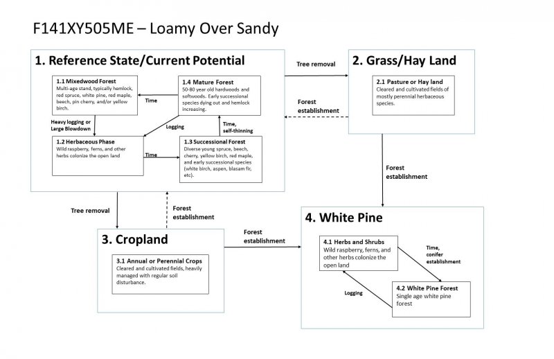
Click on box and path labels to scroll to the respective text.
