Major Land Resource Area 142X
St. Lawrence-Champlain Plain
Accessed: 04/10/2026
Description
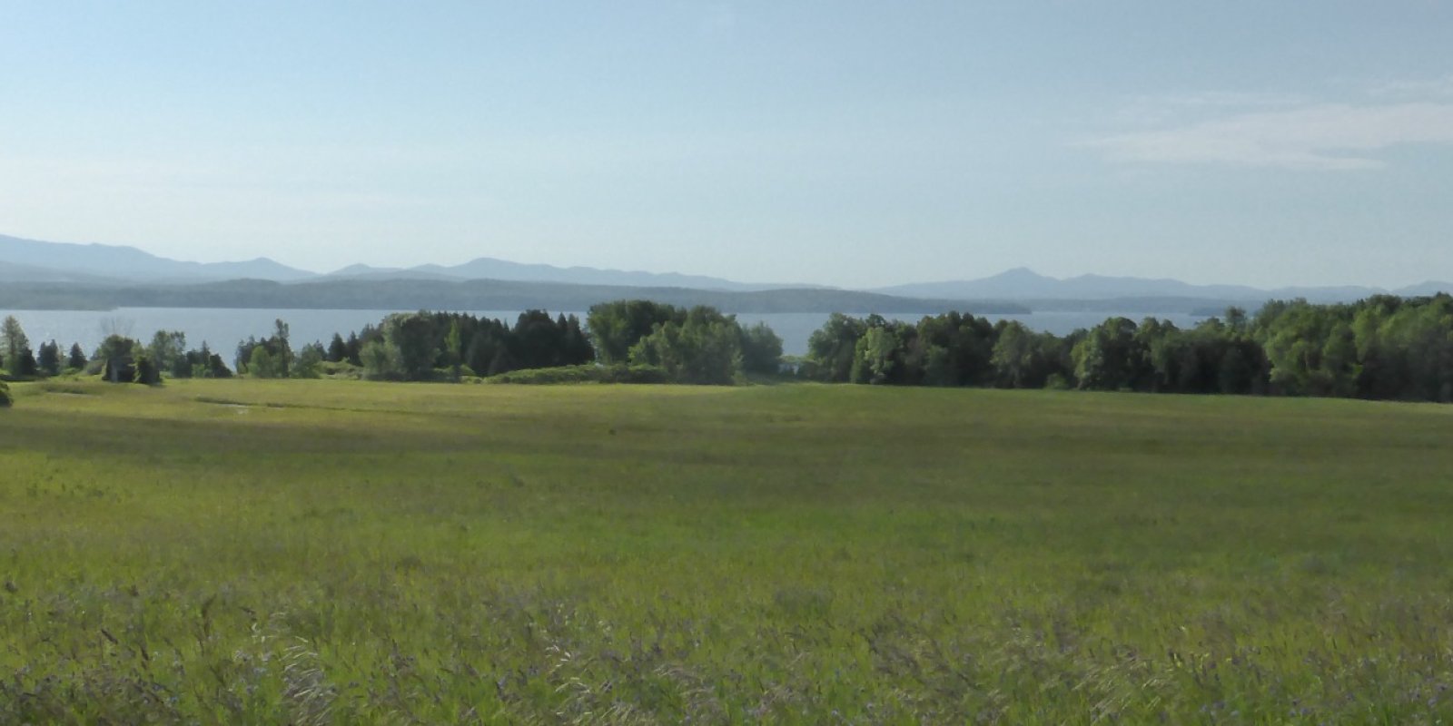
MLRA 142 is in New York (75 percent) and Vermont (25 percent). It makes up about 7,067 square miles (18,305 square kilometers). The MLRA is made up of two broad valleys, the St. Lawrence and Champlain, that coalesce to form a broad contiguous lowland underlain by relatively thick Wisconsin till, outwash, lacustrine, and marine deposits. It adjoins Lake Champlain at the New York-Vermont border. MLRA 142 is roughly U-shaped, with the open end to the south. A distinct southern boundary occurs in New York with the physiographically dissimilar Adirondack Mountains part of MLRA 143. The eastern boundary is distinct where it contacts the physiographically dissimilar Green Mountains part of MLRA 143 in Vermont. The southwestern boundary, in New York, is distinct with the physiographically dissimilar Tug Hill Plateau (MLRA 141) but is more diffuse with small parts of MLRA 101. The southeastern part of MLRA 142 forms a relatively diffuse boundary with MLRAs 144A and 144B in New York and Vermont. The northern boundary of the MLRA is he Canadian border and the St. Lawrence River. Lake Ontario is along the western boundary. The dominant soil orders are Alfisols, Inceptisols, Spodosols, and Entisols. The soils in the area have a frigid or mesic temperature regime, an aquic or udic moisture regime, and mixed or isotic mineralogy. They are shallow to very deep, excessively drained to very poorly drained, and sandy to clayey. Most of this area is in forests or farms. The forests consist of northern hardwoods and conifers. Sawlogs and pulpwood are the main forest products. Christmas trees and maple syrup also are produced throughout the area. Dairy operations and some beef operations are common. Hay for dairy cattle is the principal crop, but small grain and corn are grown for silage in some areas. Corn for grain, soybeans, and small grains also make up a significant acreage. Potatoes are an important cash crop in some areas, and a few apple orchards are on the slopes along Lake Champlain, but the total acreage of these crops is small. Some areas are used for urban development. The major soil resource concerns on cropland are sheet, rill, and gully erosion; the content of organic matter and productivity of the soils; and surface compaction (resulting primarily from the harvest of crops under wet conditions). Some erosion results from logging practices. Conservation practices on cropland generally include conservation tillage, contour stripcropping, crop rotations, crop residue management (primarily mulch-till), cover crops, diversions, and grassed waterways. Conservation practices on forestland generally include forest stand improvement and proper construction, use, and maintenance of skid trails, water bars, access roads, and log landings.
Key publications
Geographic subunits
Land Resource Unit 1. The Frigid Soil Temperature Regime LRU is located primarily in the St. Lawrence Valley and Upper Champlain Valley portions of New York and Vermont. These soils will have a mean annual temperature is between 0 and 8°C and the difference between mean summer (June, July, August) and mean winter (December, January, February) soil temperatures is 6°C or more either at a depth of 50cm below the soil surface or at root restriction, whichever is shallower (USDA Keys to Soil Taxonomy, 13th Edition). The total area of this LRU is approximately 2,300,000 acres. This LRU will have a shorter growing season than the Mesic LRU. Species more tolerant of harsher year round temperatures will be more evident in this LRU, portraying lower species diversity.
Land Resource Unit 2. The Mesic Soil Temperature Regime LRU is located primarily in the Eastern Ontario Plain and Lower Champlain Valley portions of New York and Vermont. These soils will have a mean annual soil temperature 8°C or higher but lower than 15°C and the difference between mean summer (June, July, August) and mean winter (December, January, February) soil temperatures is 6°C or more either at a depth of 50cm below the soil surface or at root restriction, whichever is shallower (USDA Keys to Soil Taxonomy, 13th Edition). The total area of this LRU is approximately 1,900,000 acres. This LRU will have a longer growing season than the Frigid LRU. Species more tolerant of milder year round temperatures will be more evident in this LRU, portraying higher species diversity.
Next steps
-
1
Select an ecological site
Select an ecological site using the list, keys, photos, briefcase, or quick search option located on this page. -
2
Explore the ecological site description
Next, learn more about the selected ecological site and its characteristic dynamics by browsing the ecological site description and exploring alternative state and transition model formats.
Ecological site list
-
i
Key Characteristics
- Site periodically flooded during the growing season, adjacent to a river or stream [Medomak, Sloan, Redwater]
-
i
Key Characteristics
- Site not periodically flooded during the growing season, not adjacent to a river or stream
- Substrate mostly organic (Histosols)
- pH greater 4.5; swamps, fens, and marshes landforms [Wonsqueak, Markey, Dorval]
-
i
Key Characteristics
- Site not periodically flooded during the growing season, not adjacent to a river or stream
- Substrate mostly organic (Histosols)
- pH less than 4.5, bog landforms [Wonsqueak, Loxley, Knob Lock, Dawson, Churubusco]
-
i
Key Characteristics
- Site not periodically flooded during the growing season, not adjacent to a river or stream
- Substrate mostly mineral (Alfisols, Inceptisols, Spodosols, Entisols)
- Parent material glacial outwash, soils coarse textured (sands) to moderately coarse textured (sandy loams)
- Soils excessively- to well-drained
- pH of upper 50 cm less than 5.5, low base saturation (acidic)
- Soils shallow (< 50cm) to root restricting ortstein layer (iron cementation) [Constable, Wallace]
-
i
Key Characteristics
- Site not periodically flooded during the growing season, not adjacent to a river or stream
- Substrate mostly mineral (Alfisols, Inceptisols, Spodosols, Entisols)
- Parent material glacial outwash, soils coarse textured (sands) to moderately coarse textured (sandy loams)
- Soils excessively- to well-drained
- pH of upper 50 cm less than 5.5, low base saturation (acidic)
- Soils very deep (>150cm) to bedrock [Stetson, Ondawa, Colosse, Adams, Melrose]
-
i
Key Characteristics
- Site not periodically flooded during the growing season, not adjacent to a river or stream
- Substrate mostly mineral (Alfisols, Inceptisols, Spodosols, Entisols)
- Parent material glacial outwash, soils coarse textured (sands) to moderately coarse textured (sandy loams)
- Soils moderately well- to very poorly- drained
- pH of upper 50 cm less than 5.5, low base saturation (acidic), water table 25-100 cm deep (moderately well- or somewhat poorly- drained) [Lovewell, Occur, Coveytown, Duane, Au Gres, Wainola, Naumburg]
-
i
Key Characteristics
- Site not periodically flooded during the growing season, not adjacent to a river or stream
- Substrate mostly mineral (Alfisols, Inceptisols, Spodosols, Entisols)
- Parent material glacial outwash, soils coarse textured (sands) to moderately coarse textured (sandy loams)
- Soils moderately well- to very poorly- drained
- pH of upper 50 cm greater than 5.5, higher base saturation (rich)
- Water table 25-100 cm deep (moderately well- or somewhat poorly- drained) [Mooers, Sheddenbrook, Fahey, Flackville, Sciota, Northway, Eelweir]
-
i
Key Characteristics
- Site not periodically flooded during the growing season, not adjacent to a river or stream
- Substrate mostly mineral (Alfisols, Inceptisols, Spodosols, Entisols)
- Parent material glacial outwash, soils coarse textured (sands) to moderately coarse textured (sandy loams)
- Soils moderately well- to very poorly- drained
- pH of upper 50 cm greater than 5.5, higher base saturation (rich)
- Water table <25 cm deep (poorly- drained) [Searsport, Deinache, Stockholm, Cook, Coveytown, Deford, Munuscong, Pinconning]
-
i
Key Characteristics
- Site not periodically flooded during the growing season, not adjacent to a river or stream
- Substrate mostly mineral (Alfisols, Inceptisols, Spodosols, Entisols)
- Parent material glacial till or glaciolacustrine, soils coarse textured (sandy loams) to fine textured (clays)
- Parent material glaciolacustrine, soils moderately coarse textured to fine textured
- Soils well- to somewhat poorly- drained
- pH of upper 50 cm less than 5.5, low base saturation (acidic) [Salmon, Nicholville]
-
i
Key Characteristics
- Site not periodically flooded during the growing season, not adjacent to a river or stream
- Substrate mostly mineral (Alfisols, Inceptisols, Spodosols, Entisols)
- Parent material glacial till or glaciolacustrine, soils coarse textured (sandy loams) to fine textured (clays)
- Parent material glaciolacustrine, soils moderately coarse textured to fine textured
- Soils well- to somewhat poorly- drained
- pH of upper 50 cm greater than 5.5, higher base saturation (rich) [Buxton, Heuvelton, Depeyster, Elmwood, Muskellunge, Matoon, Hailsboro]
-
i
Key Characteristics
- Site not periodically flooded during the growing season, not adjacent to a river or stream
- Substrate mostly mineral (Alfisols, Inceptisols, Spodosols, Entisols)
- Parent material glacial till or glaciolacustrine, soils coarse textured (sandy loams) to fine textured (clays)
- Parent material glaciolacustrine, soils moderately coarse textured to fine textured
- Soils poorly- to very poorly- drained [Adjidaumo, Guff, Wegatchie, Swanton, Whately]
-
i
Key Characteristics
- Site not periodically flooded during the growing season, not adjacent to a river or stream
- Substrate mostly mineral (Alfisols, Inceptisols, Spodosols, Entisols)
- Parent material glacial till or glaciolacustrine, soils coarse textured (sandy loams) to fine textured (clays)
- Parent material glacial till, soils moderately coarse textured to medium textured
- Soils excessively- to somewhat poorly- drained
- pH of upper 50 cm less than 5.5, low base saturation (acidic)
- Soils shallow and well- to excessively- drained (< 50cm) to bedrock [Ricker, Woodstock, Taconic, Success, Lyman, Hubbardton, Hogback, Irona, Insula, Quetico, Abram, Conic]
-
i
Key Characteristics
- Site not periodically flooded during the growing season, not adjacent to a river or stream
- Substrate mostly mineral (Alfisols, Inceptisols, Spodosols, Entisols)
- Parent material glacial till or glaciolacustrine, soils coarse textured (sandy loams) to fine textured (clays)
- Parent material glacial till, soils moderately coarse textured to medium textured
- Soils excessively- to somewhat poorly- drained
- pH of upper 50 cm greater than 5.5, higher base saturation (rich)
- Soils shallow (< 50cm) to bedrock [Gouverneur, Summerville/Kings Falls]
-
i
Key Characteristics
- Site not periodically flooded during the growing season, not adjacent to a river or stream
- Substrate mostly mineral (Alfisols, Inceptisols, Spodosols, Entisols)
- Parent material glacial till or glaciolacustrine, soils coarse textured (sandy loams) to fine textured (clays)
- Parent material glacial till, soils moderately coarse textured to medium textured
- Soils excessively- to somewhat poorly- drained
- pH of upper 50 cm greater than 5.5, higher base saturation (rich)
- Soils moderately deep to very deep (> 50cm) to bedrock or densic horizon
- Soils well- drained [Stowe, Marlow, Grenville, Pyrities, Nehasne, Neckrock, Galway cool]
-
i
Key Characteristics
- Site not periodically flooded during the growing season, not adjacent to a river or stream
- Substrate mostly mineral (Alfisols, Inceptisols, Spodosols, Entisols)
- Parent material glacial till or glaciolacustrine, soils coarse textured (sandy loams) to fine textured (clays)
- Parent material glacial till, soils moderately coarse textured to medium textured
- Soils excessively- to somewhat poorly- drained
- pH of upper 50 cm less than 5.5, low base saturation (acidic)
- Soils shallow to very deep; somewhat poorly- to well- drained [Berkshire, Monadnock, Worth, Turnbridge, Rawsonville, Parishville, Mundalite, Millsite, Macomber, Gretor, Sunapee, Westbury, Skerry, Ampersand, Chazy, Topknot, Moira, Schroon]
-
i
Key Characteristics
- Site not periodically flooded during the growing season, not adjacent to a river or stream
- Substrate mostly mineral (Alfisols, Inceptisols, Spodosols, Entisols)
- Parent material glacial till or glaciolacustrine, soils coarse textured (sandy loams) to fine textured (clays)
- Parent material glacial till, soils moderately coarse textured to medium textured
- Soils excessively- to somewhat poorly- drained
- pH of upper 50 cm greater than 5.5, higher base saturation (rich)
- Soils moderately deep to very deep (> 50cm) to bedrock or densic horizon
- Soils moderately well- or somewhat poorly- drained [Peru, Hogansburg, Kalurah, Ogdensburg, Malone, Brayton, Peasleeville]
-
i
Key Characteristics
- Site not periodically flooded during the growing season, not adjacent to a river or stream
- Substrate mostly mineral (Alfisols, Inceptisols, Spodosols, Entisols)
- Parent material glacial till or glaciolacustrine, soils coarse textured (sandy loams) to fine textured (clays)
- Parent material glacial till, soils moderately coarse textured to medium textured
- Soils poorly- to very poorly- drained) [Hannawa, Lyonmounten, Runeberg]
-
i
Key Characteristics
- Site not periodically flooded during the growing season, not adjacent to a river or stream
- Substrate mostly mineral (Alfisols, Inceptisols, Spodosols, Entisols)
- Parent material glacial outwash, soils coarse textured (sands) to moderately coarse textured (sandy loams)
- Soils excessively- to well-drained
- pH of upper 50 cm greater than greater than 5.5, higher base saturation (rich) [Missisquoi, Champlain, Waddington, Raquette, Trout River]
-
i
Key Characteristics
- Substrate mostly organic (Histosols) [Aquents, Palms, Willette/Whallonsburg]
-
i
Key Characteristics
- Substrate mostly mineral (Mollisol, Alfisols, Inceptisols, Spodosols, Entisols)
- Landform not a floodplain
- Parent material glacial outwash, soils coarse textured (sands) to moderately coarse textured (sandy loams)
- Soils somewhat poorly- to excessively- drained
- Soils well- to excessively- drained [Warwick, Tioga, Occum, Hamlin, Hadley, Kars, Factoryville, Hinesburg, Bonapart, Agawam, Arkport, Colonie, Copake, Grattan, Groton, Howard, Merrimac, Plainfield, Windsor]
-
i
Key Characteristics
- Substrate mostly mineral (Mollisol, Alfisols, Inceptisols, Spodosols, Entisols)
- Landform not a floodplain
- Parent material glacial outwash, soils coarse textured (sands) to moderately coarse textured (sandy loams)
- Soils somewhat poorly- to excessively- drained
- Soils moderately well- or somewhat poorly- drained [Teel, Podunk, pootatuck, phelps, Lobdell, Herkimer, Castile, Wareham, Eldridge, Covertfalls, Northway, Cosad, Deerfield, Homer, Pipestone]
-
i
Key Characteristics
- Substrate mostly mineral (Mollisol, Alfisols, Inceptisols, Spodosols, Entisols)
- Landform not a floodplain
- Parent material glacial outwash, soils coarse textured (sands) to moderately coarse textured (sandy loams)
- Soils poorly- to very poorly- drained [Scarboro, Rumney, Saco, Rippowam, Limerick, Gougeville, Enosburg]
-
i
Key Characteristics
- Substrate mostly mineral (Mollisol, Alfisols, Inceptisols, Spodosols, Entisols)
- Landform not a floodplain
- Parent material glacial till or glaciolacustrine, soils coarse textured (sandy loams) to fine textured (clays)
- Parent material glaciolacustrine, soils medium textured to fine textured
- Soils very poorly- to poorly- drained [Covington, Guffin, Binghamville, Livingston, Madalin, Panton]
-
-
i
Key Characteristics
- Substrate mostly mineral (Mollisol, Alfisols, Inceptisols, Spodosols, Entisols)
- Landform not a floodplain
- Parent material glacial till or glaciolacustrine, soils coarse textured (sandy loams) to fine textured (clays)
- Parent material glacial till, soils moderately coarse textured to medium textured
- Soils excessively- to well- drained
- pH of upper 50 cm greater than 5.5, higher base saturation (rich)
- Soils shallow to very shallow (< 50cm) to bedrock [Benson, Galoo, Farmington]
-
i
Key Characteristics
- Substrate mostly mineral (Mollisol, Alfisols, Inceptisols, Spodosols, Entisols)
- Landform not a floodplain
- Parent material glacial till or glaciolacustrine, soils coarse textured (sandy loams) to fine textured (clays)
- Parent material glacial till, soils moderately coarse textured to medium textured
- Soils excessively- to well- drained
- pH of upper 50 cm greater than 5.5, higher base saturation (rich)
- Soils moderately deep to very deep (> 50cm) to bedrock or densic horizon [Madrid, Nellis, Lowville, Galway, Gardenisle, Dover, Pittsfield, Stockbridge, Palatine, Farmington -moderately deep phase]
-
i
Key Characteristics
- Substrate mostly mineral (Mollisol, Alfisols, Inceptisols, Spodosols, Entisols)
- Landform not a floodplain
- Parent material glacial till or glaciolacustrine, soils coarse textured (sandy loams) to fine textured (clays)
- Parent material glacial till, soils moderately coarse textured to medium textured
- Soils moderately well- to very poorly- drained
- Soils moderately well- to somewhat poorly- drained [Amenia, Angola, Bombay, Empeyville, Georgia, Kendaia, Massena, Newstead]
-
i
Key Characteristics
- Substrate mostly mineral (Mollisol, Alfisols, Inceptisols, Spodosols, Entisols)
- Landform not a floodplain
- Parent material glacial till or glaciolacustrine, soils coarse textured (sandy loams) to fine textured (clays)
- Parent material glacial till, soils moderately coarse textured to medium textured
- Soils moderately well- to very poorly- drained
- Soils poorly- to very poorly- drained
- pH of upper 50 cm greater than 5.5, higher base saturation (rich) [Lyons, Sun]
-
i
Key Characteristics
- Substrate mostly mineral (Mollisol, Alfisols, Inceptisols, Spodosols, Entisols)
- Landform not a floodplain
- Parent material glacial till or glaciolacustrine, soils coarse textured (sandy loams) to fine textured (clays)
- Parent material glaciolacustrine, soils medium textured to fine textured
- Soils somewhat poorly- to well- drained
- Soils coarse-silty, coarse loamy over clayey, sandy over clayey (silt loam, fine sandy loam, sandy loam, loamy fine sand) [Unadilla, Hartland, Belgrade, Claverack, Elmridge, Munson, Niagara, Stafford, Tonawanda]
-
i
Key Characteristics
- Substrate mostly mineral (Mollisol, Alfisols, Inceptisols, Spodosols, Entisols)
- Landform not a floodplain
- Parent material glacial till or glaciolacustrine, soils coarse textured (sandy loams) to fine textured (clays)
- Parent material glacial till, soils moderately coarse textured to medium textured
- Soils excessively- to well- drained
- pH of upper 50 cm less than 5.5, low base saturation (acidic)
- Soils shallow to very shallow (< 50cm) to bedrock [Hollis, Galoo acid phase]
-
i
Key Characteristics
- Substrate mostly mineral (Mollisol, Alfisols, Inceptisols, Spodosols, Entisols)
- Landform not a floodplain
- Parent material glacial till or glaciolacustrine, soils coarse textured (sandy loams) to fine textured (clays)
- Parent material glacial till, soils moderately coarse textured to medium textured
- Soils moderately well- to very poorly- drained
- Soils poorly- to very poorly- drained
- pH of upper 50 cm less than 5.5, low base saturation (acidic) [Ridgebury, Whitman]
-
i
Key Characteristics
- Substrate mostly mineral (Mollisol, Alfisols, Inceptisols, Spodosols, Entisols)
- Landform not a floodplain
- Parent material glacial till or glaciolacustrine, soils coarse textured (sandy loams) to fine textured (clays)
- Parent material glaciolacustrine, soils medium textured to fine textured
- Soils somewhat poorly- to well- drained
- Soils fine to very fine texture (clay, clay loam, silty clay loam) [Vergennes, Wilpoint Cayuga, Hudson, Chaumont, Churchville, Kingsbury, Rhinebeck]
Ecological site map
Basemap
Find me
Find point
Full screen
Zoom in to display soil survey map units for an area of interest, and zoom out to display MLRAs. Select a map unit polygon to view ecological sites correlated to that map unit. View a brief description of an ecological site by clicking on its name in the map popup. Soil survey correlations may not be accurate, and ecological site classification of a location should always be verified in the field. Each selection may require the transfer of several hundred KB of data.
Ecological site keys
Ecological site photos
Print Options
Sections
Font
Other
Briefcase
Add ecological sites and Major Land Resource Areas to your briefcase by clicking on the briefcase (![]() ) icon wherever it occurs. Drag and drop items to reorder. Cookies are used to store briefcase items between browsing sessions. Because of this, the number of items that can be added to your briefcase is limited, and briefcase items added on one device and browser cannot be accessed from another device or browser. Users who do not wish to place cookies on their devices should not use the briefcase tool. Briefcase cookies serve no other purpose than described here and are deleted whenever browsing history is cleared.
) icon wherever it occurs. Drag and drop items to reorder. Cookies are used to store briefcase items between browsing sessions. Because of this, the number of items that can be added to your briefcase is limited, and briefcase items added on one device and browser cannot be accessed from another device or browser. Users who do not wish to place cookies on their devices should not use the briefcase tool. Briefcase cookies serve no other purpose than described here and are deleted whenever browsing history is cleared.
Ecological sites
Major Land Resource Areas
The Ecosystem Dynamics Interpretive Tool is an information system framework developed by the USDA-ARS Jornada Experimental Range, USDA Natural Resources Conservation Service, and New Mexico State University.