Natural Resources
Conservation Service
Ecological site F144AY016MA
Very Wet Low Floodplain
Last updated: 10/04/2024
Accessed: 04/12/2026
General information
Provisional. A provisional ecological site description has undergone quality control and quality assurance review. It contains a working state and transition model and enough information to identify the ecological site.
MLRA notes
Major Land Resource Area (MLRA): 144A–New England and Eastern New York Upland, Southern Part
MLRA 144A: New England and Eastern New York Upland, Southern Part
The eastern half of the eastern part of this MLRA is in the Seaboard Lowland Section of the New England Province of the Appalachian Highlands. The western half of the eastern part and the southeastern half of the western part are in the New England Upland Section of the same province and division. The northwestern half of the western part is in the Hudson Valley Section of the Valley and Ridge Province of the Appalachian Highlands. This MLRA is a very scenic area of rolling to hilly uplands that are broken by many gently sloping to level valleys that terminate in coastal lowlands. Elevation ranges from sea level to 1,000 feet in much of the area, but it is 2,000 feet on some hills. Relief is mostly about 6 to 65 feet in the valleys and about 80 to 330 feet in the uplands.
This area has been glaciated and consists almost entirely of till hills, drumlins, and bedrock-controlled uplands with a mantle of till. It is dissected by narrow glacio-fluvial valleys. The southernmost boundary of the area marks the farthest southward extent of Wisconsinian glaciation on the eastern seaboard. The river valleys and coastal plains are filled with glacial lake sediments, marine sediments, and glacial outwash. The bedrock in the eastern half of the area consists primarily of igneous and metamorphic rocks of early Paleozoic age. Granite is the most common igneous rock, and gneiss, schist, and slate are the most common metamorphic rocks. In the parts of the MLRA in eastern and southeastern New York, Devonian- to Pennsylvanian-age sandstone, shale, and limestone are dominant. Carbonate rocks, primarily dolomite and limestone, are the dominant kinds of bedrock in the part of this MLRA in northwestern Connecticut.
Classification relationships
USDA-NRCS (USDA 2006):
Land Resource Region (LRR): N—East and Central Farming and Forest Region
Major Land Resource Area (MLRA): 144A— New England and Eastern New York Upland, Southern Part.
USDA-FS (Cleland et al. 2007)
Province: 221 - Eastern Broadleaf Province
Section: 221A - Lower New England
Subsection: 221Aa – Boston Basin
221Ac – Narragansett-Bristol Lowland and Islands
221Ad – Southern New England Coastal Lowland
221Ae – Hudson Highlands
221Ag - Southeast New England Coastal Hills and Plains
221Ah - Worcester-Monadnock Plateau
221Ai – Gulf of Maine Coastal Plain
221Ak - Gulf of Maine Coastal Lowland
Section: 221B – Hudson Valley
Subsection: 221Ba – Hudson Limestone Valley
221Bb - Miami – Taconic Foothills
221Bc – Hudson Glacial Lake Plains
Ecological site concept
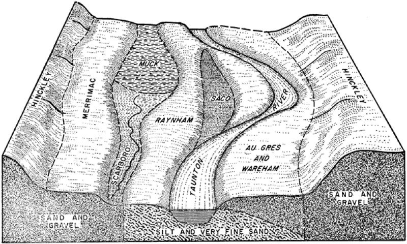
The site consists of deep, coarse-silty, very poorly drained, alluvial soils on low floodplains of variously sized river valleys. These floodplains are subject annual flooding. Water is at or near the surface for much of the growing season. The representative soil is Saco, Sloan, Wallkill, and Wayland.
The reference plant community is considered to be an alluvial shrubland swamp. Alders (Alnus spp.) are the most common shrub but other shrubs such as silky dogwood (Cornus amomum), willows (Salix spp.), highbush blueberry (Vaccinium corymbosum), winterberry (Ilex vericillata), steeplebush (Spiraea tomentosa) and common buttonbush (Cephalanthus occidentalis). Devil’s darning needles (Clematis virginiana) is a vine that may be found tangled over the shrubs. Canada bluejoint (Calamagrostis canadensis), smallspike false nettle (Boehmeria cylindrica), wild rye (Elymus spp.) and tussock sedge (Carex stricta) may also be present. Red maple (Acer rubrum) may occur but tree cover is low due to the very wet conditions.
Associated sites
| F144AY014CT |
Wet Sandy Low Floodplain |
|---|---|
| F144AY015NY |
Wet Silty Low Floodplain |
Similar sites
| F144AY006CT |
High Floodplain Levee |
|---|
Table 1. Dominant plant species
| Tree |
(1) Acer rubrum |
|---|---|
| Shrub |
(1) Alnus serrulata |
| Herbaceous |
(1) Carex stricta |
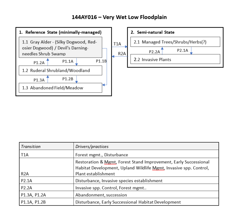
Click on box and path labels to scroll to the respective text.