Natural Resources
Conservation Service
Ecological site F144AY033MA
Shallow Dry Till Uplands
Last updated: 10/04/2024
Accessed: 04/10/2026
General information
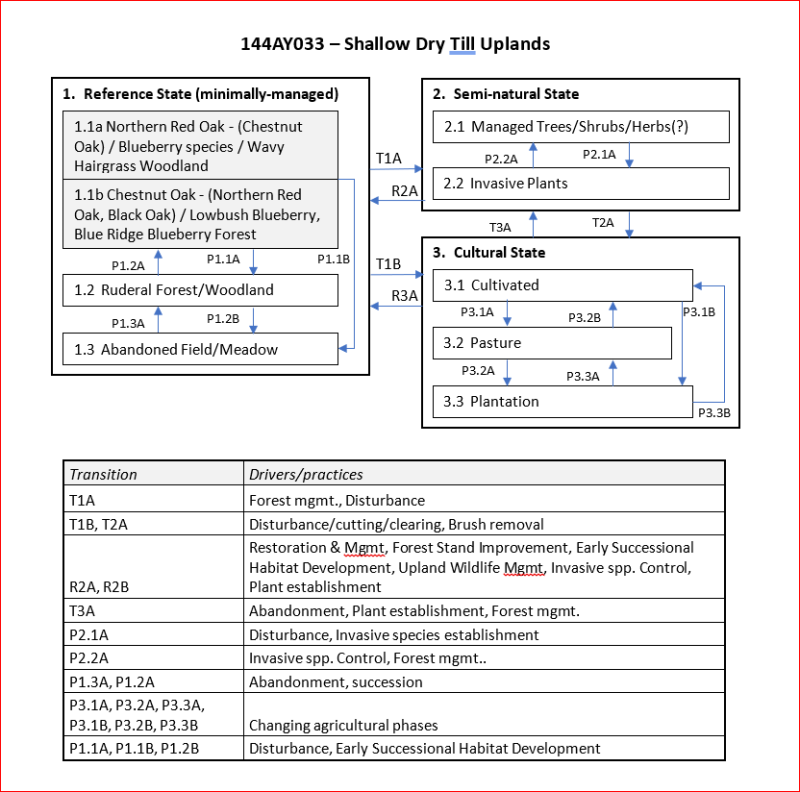
Provisional. A provisional ecological site description has undergone quality control and quality assurance review. It contains a working state and transition model and enough information to identify the ecological site.
MLRA notes
Major Land Resource Area (MLRA): 144A–New England and Eastern New York Upland, Southern Part
MLRA 144A: New England and Eastern New York Upland, Southern Part
The eastern half of the eastern part of this MLRA is in the Seaboard Lowland Section of the New England Province of the Appalachian Highlands. The western half of the eastern part and the southeastern half of the western part are in the New England Upland Section of the same province and division. The northwestern half of the western part is in the Hudson Valley Section of the Valley and Ridge Province of the Appalachian Highlands. This MLRA is a very scenic area of rolling to hilly uplands that are broken by many gently sloping to level valleys that terminate in coastal lowlands. Elevation ranges from sea level to 1,000 feet (0 to 305 meters) in much of the area, but it is 2,000 feet (610 meters) on some hills. Relief is mostly about 6 to 65 feet (2 to 20 meters) in the valleys and about 80 to 330 feet (25 to 100 meters) in the uplands.
This area has been glaciated and consists almost entirely of till hills, drumlins, and bedrock-controlled uplands with a mantle of till. It is dissected by narrow glacio-fluvial valleys. The southernmost boundary of the area marks the farthest southward extent of Wisconsinian glaciation on the eastern seaboard. The river valleys and coastal plains are filled with glacial lake sediments, marine sediments, and glacial outwash. The bedrock in the eastern half of the area consists primarily of igneous and metamorphic rocks of early Paleozoic age. Granite is the most common igneous rock, and gneiss, schist, and slate are the most common metamorphic rocks. In the parts of the MLRA in eastern and southeastern New York, Devonian- to Pennsylvanian-age sandstone, shale, and limestone are dominant. Carbonate rocks, primarily dolomite and limestone, are the dominant kinds of bedrock in the part of this MLRA in northwestern Connecticut.
Classification relationships
USDA-NRCS (USDA 2006):
Land Resource Region (LRR): N—East and Central Farming and Forest Region
Major Land Resource Area (MLRA): 144A— New England and Eastern New York Upland, Southern Part.
USDA-FS (Cleland et al. 2007)
Province: 221 - Eastern Broadleaf Province
Section: 221A - Lower New England
Subsection: 221Aa – Boston Basin
221Ac – Narragansett-Bristol Lowland and Islands
221Ad – Southern New England Coastal Lowland
221Ae – Hudson Highlands
221Ag - Southeast New England Coastal Hills and Plains
221Ah - Worcester-Monadnock Plateau
221Ai – Gulf of Maine Coastal Plain
221Ak - Gulf of Maine Coastal Lowland
Section: 221B – Hudson Valley
Subsection: 221Ba – Hudson Limestone Valley
221Bb - Miami – Taconic Foothills
221Bc – Hudson Glacial Lake Plains
Ecological site concept
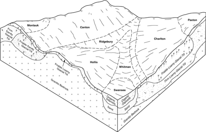
The Shallow Dry Till Uplands ecological site consists of shallow, somewhat excessively drained, coarse-loamy, glacial till derived mostly from gneiss, schist, and granite. Soils are dry and nutrient poor. Slopes range from 0 to 50 percent on hills and ridges. Representative soils are Hollis, Brimfield, and Nassau. The reference plant community is an oak dominated forest or woodland. Representative plant communities are typically dominated by oaks (Quercus spp.) and/or pines (Pinus spp.).
Associated sites
| F144AY007CT |
Well Drained Dense Till Uplands |
|---|---|
| F144AY032NH |
Dry Till Uplands |
Similar sites
| F144AY036NY |
Semi-Rich Well Drained Till Uplands |
|---|---|
| F144AY038NY |
Semi-Rich Moist Till Uplands |
Table 1. Dominant plant species
| Tree |
(1) Quercus velutina |
|---|---|
| Shrub |
(1) Gaylussacia baccata |
| Herbaceous |
(1) Carex pensylvanica |
Click on box and path labels to scroll to the respective text.