Natural Resources
Conservation Service
Ecological site R144AY049RI
Subaqueous Haline Slopes
Last updated: 10/04/2024
Accessed: 04/10/2026
General information
Provisional. A provisional ecological site description has undergone quality control and quality assurance review. It contains a working state and transition model and enough information to identify the ecological site.
MLRA notes
Major Land Resource Area (MLRA): 144A–New England and Eastern New York Upland, Southern Part
MLRA 144A: New England and Eastern New York Upland, Southern Part
The eastern half of the eastern part of this MLRA is in the Seaboard Lowland Section of the New England Province of the Appalachian Highlands. The western half of the eastern part and the southeastern half of the western part are in the New England Upland Section of the same province and division. The northwestern half of the western part is in the Hudson Valley Section of the Valley and Ridge Province of the Appalachian Highlands. This MLRA is a very scenic area of rolling to hilly uplands that are broken by many gently sloping to level valleys that terminate in coastal lowlands. Elevation ranges from sea level to 1,000 feet (0 to 305 meters) in much of the area, but it is 2,000 feet (610 meters) on some hills. Relief is mostly about 6 to 65 feet (2 to 20 meters) in the valleys and about 80 to 330 feet (25 to 100 meters) in the uplands.
This area has been glaciated and consists almost entirely of till hills, drumlins, and bedrock-controlled uplands with a mantle of till. It is dissected by narrow glacio-fluvial valleys. The southernmost boundary of the area marks the farthest southward extent of Wisconsinian glaciation on the eastern seaboard. The river valleys and coastal plains are filled with glacial lake sediments, marine sediments, and glacial outwash. The bedrock in the eastern half of the area consists primarily of igneous and metamorphic rocks of early Paleozoic age. Granite is the most common igneous rock, and gneiss, schist, and slate are the most common metamorphic rocks. In the parts of the MLRA in eastern and southeastern New York, Devonian- to Pennsylvanian-age sandstone, shale, and limestone are dominant. Carbonate rocks, primarily dolomite and limestone, are the dominant kinds of bedrock in the part of this MLRA in northwestern Connecticut.
Ecological site concept
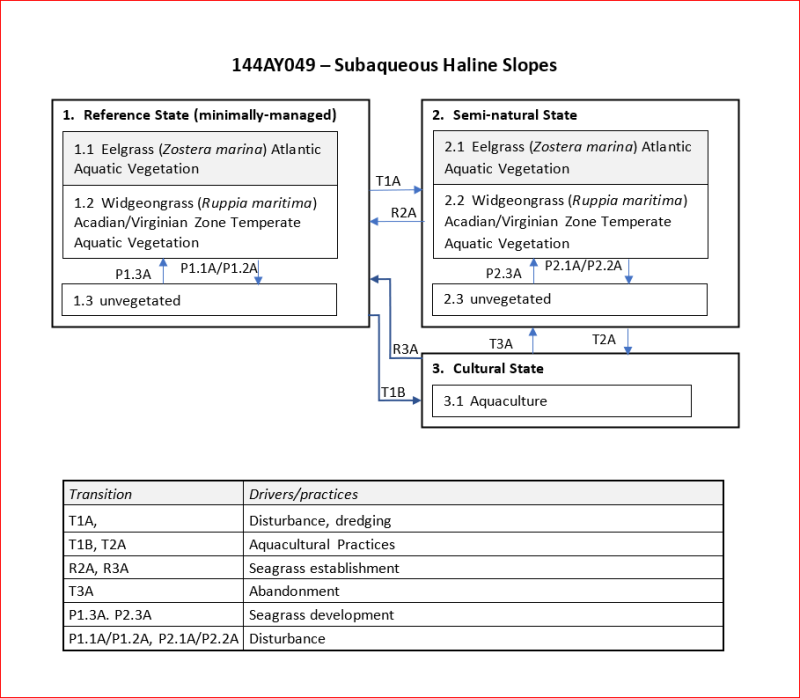
The Subaqueous Haline Slopes ecological site consists of very deep, subaqueous soils permanently submerged beneath 100 through 250 cm of tidal estuarine water on flood tidal delta slopes and slopes in coastal lagoons and bays. Slope ranges from 2 through 15 percent. Representative soils are Marshneck and Nagunt sloping phase. Marshneck soils are formed in coarse loamy marine and estuarine sediments transported by flood tidal currents and estuarine silts. Nagunt soils are formed in sandy marine deposits as a result of washover events, eolian deposition, and tidal flooding. Buried surface horizons and stratification are often identified. Native vegetation includes eelgrass (Zostera marina) and widgeon grass (Ruppia maritma). Vegetation cover ranges from 0 in shallow and intertidal flats through 80 percent on sloping units of this soil. Benthic fauna such as tubeworms, clams, juvenile blue crabs, scallops and juvenile finfish are associated with this soil. Native vegetation includes eelgrass (Zostera marina) and widgeon grass (Ruppia maritma). Vegetation cover ranges from 0 in shallow and intertidal flats through 80 percent on sloping units of this soil. Areas of this soil are used for recreational fishing and boating. Commercial uses include shell fishing and aquaculture.
Associated sites
| R144AY047RI |
Subaqueous Haline Glacial Deposits |
|---|---|
| R144AY048RI |
Subaqueous Haline Low Energy Basins |
| R144AY050RI |
Subaqueous Haline Flats |
Similar sites
| R144AY047RI |
Subaqueous Haline Glacial Deposits |
|---|---|
| R144AY048RI |
Subaqueous Haline Low Energy Basins |
| R144AY050RI |
Subaqueous Haline Flats |
Table 1. Dominant plant species
| Tree |
Not specified |
|---|---|
| Shrub |
Not specified |
| Herbaceous |
(1) Zostera marina |
Click on box and path labels to scroll to the respective text.