Natural Resources
Conservation Service
Ecological site F144BY110ME
Broad Floodplain Riparian Complex
Last updated: 9/27/2024
Accessed: 04/27/2025
General information
Provisional. A provisional ecological site description has undergone quality control and quality assurance review. It contains a working state and transition model and enough information to identify the ecological site.
MLRA notes
Major Land Resource Area (MLRA): 144B–New England and Eastern New York Upland, Northern Part
Major Land Resource Area (MLRA): 144B–New England and Eastern New York Upland, Northern Part
This major land resource area (MLRA) is characterized by plateaus, plains, and mountains. The climate is generally cool and humid with an average annual precipitation of 34 to 62 inches (865 to 1,575 millimeters). The average annual air temperature is typically 40 to 48 degrees F (4 to 9 degrees C). The freeze-free period generally is 130 to 200 days, but it ranges from 110 days in the higher mountains to 240 days in some areas along the Atlantic coast. The soils in this region are dominantly Entisols, Spodosols, and Inceptisols. They commonly have a fragipan. The dominant suborders are Ochrepts, Orthods, Aquepts, Fluvents, and Saprists. The soils in the region dominantly have a frigid soil temperature regime with some cryic areas at higher elevation, a udic soil moisture regime, and mixed mineralogy. Most of the land is forested, and 98 percent is privately owned. Significant amounts of forest products are produced including lumber, pulpwood, Christmas trees, and maple syrup. Principal agricultural crops include forage and grains for dairy cattle, potatoes, apples, and blueberries. Wildlife habitat and recreation are important land uses. Stoniness, steep slopes, and poor drainage limit the use of many of the soils.
Classification relationships
NRCS:
Land Resource Region: R—Northeastern Forage and Forest Region
MLRA: 144B—New England and Eastern New York Upland, Northern PartMLRA resources
Major Land Resource Area (MLRA): 144B–New England and Eastern New York Upland, Northern Part
Ecological site concept
This site occurs next to large rivers and includes a complex of soils and landforms associated with floodplains. Well-drained natural levees occur near the stream bank, with broad, somewhat poorly to moderately well-drained floodplains behind. Side channels often carry water past the levees into the floodplains during high water, the lowest areas of the floodplain, including poorly- and very poorly-drained oxbows and depressions, may be ponded at times. These soils are derived from alluvium, are typically silt loams to fine sands in texture, and may have gravel or sand layers from particular flooding events. Poorly-drained soils are often organic over alluvium.
The variability in microtopography on this site results in a patchy mosaic of plant communities. Silver maple is the most common overstory species, with diverse grasses and herbs indicating differences in soil wetness throughout the site due to slight variability in elevation above the water table. This site is subject to ice scour and flooding, but the most extensive disturbance is cultivation. These broad, flat landforms are nutrient rich with high water-holding capacity. These factors along with their adjacency to rivers made them ideal farming locations for early settlers, much of which continues today. The effects of altered flow regimes from modern dams may also be significant, but require further study.
Similar sites
| F144BY120ME |
Small Floodplain Riparian Complex (reserved) The Small Floodplains site occurs next to small rivers and streams, supports mostly herbaceous species, and has floodplains too small for extensive cultivation; whereas the Broad Floodplains site occurs next to large rivers supporting tree cover and extensive vegetation. |
|---|
Table 1. Dominant plant species
| Tree |
(1) Acer saccharinum |
|---|---|
| Shrub |
Not specified |
| Herbaceous |
Not specified |
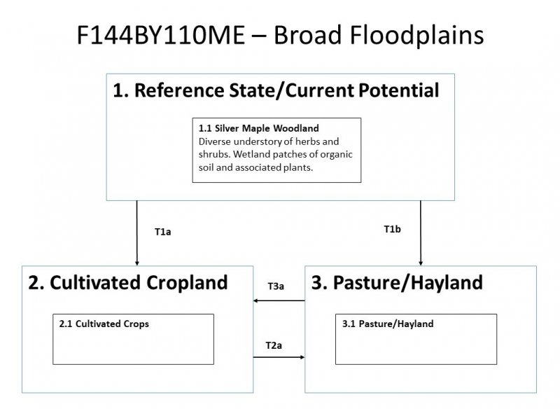
Click on box and path labels to scroll to the respective text.
