Natural Resources
Conservation Service
Ecological site F144BY210ME
Marsh Wetland Complex
Last updated: 5/13/2025
Accessed: 04/04/2026
General information
Provisional. A provisional ecological site description has undergone quality control and quality assurance review. It contains a working state and transition model and enough information to identify the ecological site.
MLRA notes
Major Land Resource Area (MLRA): 144B–New England and Eastern New York Upland, Northern Part
This major land resource area (MLRA) is in Maine (56 percent), New Hampshire (22 percent), Vermont (14 percent), Massachusetts (6 percent), Connecticut (1 percent), and New York (1 percent). It makes up about 22,728 square miles (58,864 square kilometers). The MLRA consists of a relatively young landscape shaped by the Laurentide Ice Sheet, which covered the region from 35,000 to 10,000 years ago. Rolling hills of dense basal till converge on ridges of shallow bedrock that were scoured by glacial ice. River valleys that were flooded by melting glacial water or seawater house large expanses of glacial outwash and stratified drift in inland areas and, to a lesser extent, glaciomarine and glaciolacustrine sediment deposits in coastal areas. Organic bogs, ablation till, and alluvial flood plains make up the remaining portions of the MLRA.
The soils in this region are dominantly Entisols, Spodosols, and Inceptisols. They commonly have a fragipan. The dominant suborders are Ochrepts, Orthods, Aquepts, Fluvents, and Saprists. The soils in the region dominantly have a frigid soil temperature regime with some cryic areas at higher elevation, a udic soil moisture regime, and mixed mineralogy. Most of the land is forested, and 98 percent is privately owned. Significant amounts of forest products are produced including lumber, pulpwood, Christmas trees, and maple syrup. Principal agricultural crops include forage and grains for dairy cattle, potatoes, apples, and blueberries. Wildlife habitat and recreation are important land uses. Stoniness, steep slopes, and poor drainage limit the use of many of the soils.
Classification relationships
NRCS: Land Resource Region: R—Northeastern Forage and Forest Region
Major Land Resource Area (MLRA): 144B–New England and Eastern New York Upland, Northern Part
Ecological site concept
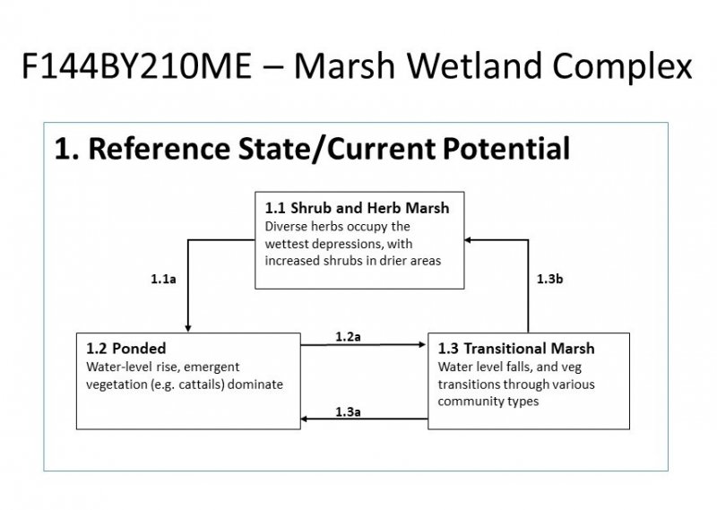
This site occurs in flat, marshy areas characterized by herbaceous and/or shrubby vegetation with very few trees. The soils are very deep, very poorly-drained, and formed in well-decomposed organic deposits (muck), generally lacking rock and grit in the upper 40 inches of the profile.
The primary driver of plant community dynamics are hydrology and associated nutrient dynamics. This ecological site requires further study, particularly with regards to the influence of hydrology for distinguishing between the many distinct plant communities that occur on these open marshland soils. The primary disturbance on these sites is likely the construction of beaver dams or man-made structures which raise or lower the water table, thereby altering the nutrient dynamics that drive species composition and organic matter decomposition in the soil.
Similar sites
| F144BY230ME |
Acidic Peat Wetland Complex The Acidic Peat Wetland Complex is characterized by poorly-decomposed peat rather than highly decomposed muck. The soil oxygen and nutrient levels are much lower than in the Marsh site, and soil pH is less than 4.5, resulting in greater sphagnum moss, pitcher plants, and other acid bog vegetation. |
|---|---|
| F144BY220ME |
Semi-acidic Peat Wetland Complex The Semi-acidic Peat Wetland Complex is characterized by poorly-decomposed peat rather than highly decomposed muck. The soil oxygen and nutrient levels are lower than in the Marsh site, resulting in greater sphagnum moss, heath shrubs, and other bog vegetation. |
Table 1. Dominant plant species
| Tree |
(1) Abies balsamea |
|---|---|
| Shrub |
Not specified |
| Herbaceous |
Not specified |
Click on box and path labels to scroll to the respective text.