Natural Resources
Conservation Service
Ecological site F144BY305ME
Wet Loamy Flat
Last updated: 9/27/2024
Accessed: 04/06/2026
General information
Provisional. A provisional ecological site description has undergone quality control and quality assurance review. It contains a working state and transition model and enough information to identify the ecological site.
MLRA notes
Major Land Resource Area (MLRA): 144B–New England and Eastern New York Upland, Northern Part
This major land resource area (MLRA) is in Maine (56 percent), New Hampshire (22 percent), Vermont (14 percent), Massachusetts (6 percent), Connecticut (1 percent), and New York (1 percent). It makes up about 22,728 square miles (58,864 square kilometers). The MLRA consists of a relatively young landscape shaped by the Laurentide Ice Sheet, which covered the region from 35,000 to 10,000 years ago. Rolling hills of dense basal till converge on ridges of shallow bedrock that were scoured by glacial ice. River valleys that were flooded by melting glacial water or seawater house large expanses of glacial outwash and stratified drift in inland areas and, to a lesser extent, glaciomarine and glaciolacustrine sediment deposits in coastal areas. Organic bogs, ablation till, and alluvial flood plains make up the remaining portions of the MLRA.
The soils in this region are dominantly Entisols, Spodosols, and Inceptisols. They commonly have a fragipan. The dominant suborders are Ochrepts, Orthods, Aquepts, Fluvents, and Saprists. The soils in the region dominantly have a frigid soil temperature regime with some cryic areas at higher elevation, a udic soil moisture regime, and mixed mineralogy. Most of the land is forested, and 98 percent is privately owned. Significant amounts of forest products are produced including lumber, pulpwood, Christmas trees, and maple syrup. Principal agricultural crops include forage and grains for dairy cattle, potatoes, apples, and blueberries. Wildlife habitat and recreation are important land uses. Stoniness, steep slopes, and poor drainage limit the use of many of the soils.
Classification relationships
NRCS:
Land Resource Region: R—Northeastern Forage and Forest Region
MLRA: 144B—New England and Eastern New York Upland, Northern PartMLRA resources
Major Land Resource Area (MLRA): 144B–New England and Eastern New York Upland, Northern Part
Ecological site concept
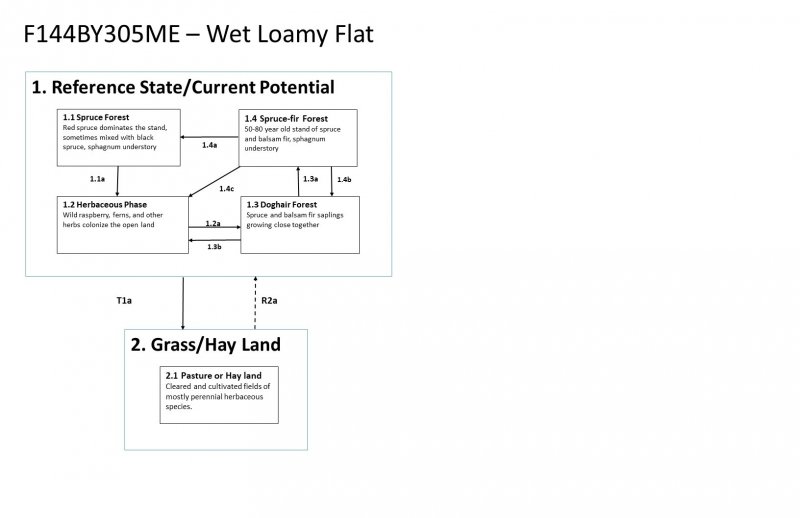
This site occurs in gently sloping areas near the bottom of watersheds where water saturates glacial till deposits for much of the growing season. Soils are poorly-drained with loamy surface textures and till parent materials. The water table is seasonally high (within 18 inches of the surface) and typically dries out in late summer and fall. This site is typically drier than Loamy Till Swamp and Acidic Swamp sites, is not usually ponded, and does not include a major component of very poorly-drained soils. Red spruce and/or black spruce dominate, sometime intermixed with larch, and balsam fir is common in younger patches. Sphagnum mosses, cinnamon fern and other herbs are often abundant in the understory.
Associated sites
| F144BY301ME |
Loamy Till Swamp The Wet Loamy Flat site occurs on poorly-drained flats, which are somewhat drier and may occur upslope from the Loamy Till Swamp. Wet Flats support more spruce and less cedar. |
|---|---|
| F144BY503ME |
Loamy Flat The Loamy Flat site occurs on somewhat-poorly and poorly-drained soil complexes that are somewhat drier and have significantly less understory production than the Wet Loamy Flat site. |
Similar sites
| F144BY302ME |
Mucky Swamp Both the Mucky Peat Swamp and the Loamy Till Swamp are dominated by northern white cedar, but the Mucky Peat Swamp is wetter, has a thicker organic soil surface layer, and typically has a more open canopy, allowing more light to reach the forest floor. As a result, the understory is often more productive in the Mucky Peat Swamp. |
|---|---|
| F144BY301ME |
Loamy Till Swamp While both sites are derived from loamy lodgment till parent materials, the Wet Loamy Flat is drier than the Loamy Till Swamp, with poorly-drained mineral soils rather than very poorly- and very-poorly drained organic soils and mineral soils. Wet Loamy Flat is dominated by spruce rather than northern white cedar. |
| F144BY303ME |
Acidic Swamp The Loamy Wet Flat site is drier than the Acidic Swamp site, with poorly-drained mineral soils rather than very poorly- and very-poorly drained organic soils and mineral soils. Loamy wet flat typically supports more red spruce than black spruce. |
| F144BY503ME |
Loamy Flat The Loamy Flat site occurs on somewhat-poorly and poorly-drained soil complexes that are somewhat drier and have significantly less understory production than the Wet Loamy Flat site. |
Table 1. Dominant plant species
| Tree |
(1) Acer rubrum |
|---|---|
| Shrub |
Not specified |
| Herbaceous |
Not specified |
Click on box and path labels to scroll to the respective text.