Natural Resources
Conservation Service
Ecological site F144BY601ME
Dry Sand
Last updated: 9/27/2024
Accessed: 04/06/2026
General information
Provisional. A provisional ecological site description has undergone quality control and quality assurance review. It contains a working state and transition model and enough information to identify the ecological site.
MLRA notes
Major Land Resource Area (MLRA): 144B–New England and Eastern New York Upland, Northern Part
This major land resource area (MLRA) is in Maine (56 percent), New Hampshire (22 percent), Vermont (14 percent), Massachusetts (6 percent), Connecticut (1 percent), and New York (1 percent). It makes up about 22,728 square miles (58,864 square kilometers). The MLRA consists of a relatively young landscape shaped by the Laurentide Ice Sheet, which covered the region from 35,000 to 10,000 years ago. Rolling hills of dense basal till converge on ridges of shallow bedrock that were scoured by glacial ice. River valleys that were flooded by melting glacial water or seawater house large expanses of glacial outwash and stratified drift in inland areas and, to a lesser extent, glaciomarine and glaciolacustrine sediment deposits in coastal areas. Organic bogs, ablation till, and alluvial flood plains make up the remaining portions of the MLRA.
The soils in this region are dominantly Entisols, Spodosols, and Inceptisols. They commonly have a fragipan. The dominant suborders are Ochrepts, Orthods, Aquepts, Fluvents, and Saprists. The soils in the region dominantly have a frigid soil temperature regime with some cryic areas at higher elevation, a udic soil moisture regime, and mixed mineralogy. Most of the land is forested, and 98 percent is privately owned. Significant amounts of forest products are produced including lumber, pulpwood, Christmas trees, and maple syrup. Principal agricultural crops include forage and grains for dairy cattle, potatoes, apples, and blueberries. Wildlife habitat and recreation are important land uses. Stoniness, steep slopes, and poor drainage limit the use of many of the soils.
Classification relationships
NRCS:
Land Resource Region: R—Northeastern Forage and Forest Region
MLRA: 144B—New England and Eastern New York Upland, Northern Part
Ecological site concept
Additional research and on-site data collection is needed to further develop interpretations for this ecological site.
Table 1. Dominant plant species
| Tree |
(1) Pinus strobus |
|---|---|
| Shrub |
Not specified |
| Herbaceous |
Not specified |
Physiographic features
This site usually occurs on landforms comprised of sandy glacial outwash deposits such as eskers, kame terraces and outwash plains, and can also occur on sandy till deposits such as moraines and till plains. It can be found from sea level to 3810 feet on slopes ranging from 0 to 45 percent, sometimes up to 60 percent.
Table 2. Representative physiographic features
| Landforms |
(1)
Outwash plain
> Outwash delta
(2) Plains > River valley (3) Upland > Kame (4) Upland > Esker (5) Upland > Kame terrace (6) Upland > Moraine (7) Upland > Hill (8) Upland > Ridge (9) Valley > Kame (10) Valley > Outwash plain (11) Valley > Outwash terrace (12) Hillslope (13) Terrace |
|---|---|
| Runoff class | Very low to high |
| Flooding frequency | None |
| Ponding frequency | None |
| Elevation | 3,805 ft |
| Slope | 60% |
| Ponding depth | 6 in |
| Water table depth | 24 – 72 in |
| Aspect | Aspect is not a significant factor |
Climatic features
The climate is humid and temperate and is characterized by warm summers and cold winters. Precipitation generally is evenly distributed throughout the year. Near the coast, it is slightly lower in summer. In inland areas, it is slightly higher in spring and fall. Rainfall occurs during high-intensity, convective thunderstorms in summer. In winter, most of the precipitation occurs as moderate-intensity storms (northeasters) that produce large amounts of rain or snow. Heavy snowfalls commonly occur late in winter. Temperatures and the length of the freeze-free period increase from north to south and closer to the coast.
This major land resource area (MLRA) covers four states and may have substantial climate variability among locations: Maine (56 percent), New Hampshire (22 percent), Vermont (14 percent), Massachusetts (6 percent), Connecticut (1 percent), and New York (1 percent).
Table 3. Representative climatic features
| Frost-free period (characteristic range) | 117-140 days |
|---|---|
| Freeze-free period (characteristic range) | 144-170 days |
| Precipitation total (characteristic range) | 42-48 in |
| Frost-free period (actual range) | 98-146 days |
| Freeze-free period (actual range) | 133-180 days |
| Precipitation total (actual range) | 40-54 in |
| Frost-free period (average) | 126 days |
| Freeze-free period (average) | 159 days |
| Precipitation total (average) | 46 in |
Figure 1. Monthly precipitation range
Figure 2. Monthly minimum temperature range
Figure 3. Monthly maximum temperature range
Figure 4. Monthly average minimum and maximum temperature
Figure 5. Annual precipitation pattern
Figure 6. Annual average temperature pattern
Climate stations used
-
(1) BELFAST [USC00170480], Belfast, ME
-
(2) ACADIA NP [USC00170100], Bar Harbor, ME
-
(3) CORINNA [USC00171628], Corinna, ME
-
(4) DOVER-FOXCROFT WWTP [USC00171975], Dover Foxcroft, ME
-
(5) FARMINGTON [USC00172765], Farmington, ME
-
(6) GARDINER [USC00173046], Gardiner, ME
-
(7) JONESBORO [USC00174183], Addison, ME
-
(8) LEWISTON [USC00174566], Auburn, ME
-
(9) MADISON [USC00174927], Anson, ME
-
(10) NEWCASTLE [USC00175675], Newcastle, ME
-
(11) ORONO [USC00176430], Old Town, ME
-
(12) WATERVILLE TRTMT PLT [USC00179151], Waterville, ME
-
(13) WEST ROCKPORT 1 NNW [USC00179593], Rockport, ME
-
(14) AUGUSTA STATE AP [USW00014605], Augusta, ME
-
(15) BANGOR INTL AP [USW00014606], Bangor, ME
-
(16) PORTLAND INTL JETPORT [USW00014764], Portland, ME
Influencing water features
This site is not influenced by streams or wetlands.
Soil features
The soils of this site are sandy throughout, sometimes with a thin sandy loam surface horizon. They formed in glaciofluvial deposits or meltout till deposited by receding glaciers. Rock fragments may or may not be present on the soil surface and throughout the profile. These soils are well- to excessively-drained.
The representative soils are Colton, Adams, Monadnock, Hermon, Udipsamments, Masardis, Hinckley, Windsor, Merrimac, Champlain, Boscawen, Gloucester, Duxbury, Groton, Stetson, Masardis variant, Teago, Pomfret, Windsor variant, and Caesar.
Table 4. Representative soil features
| Parent material |
(1)
Outwash
(2) Till (3) Supraglacial meltout till – granite and gneiss (4) Glaciofluvial deposits – schist |
|---|---|
| Surface texture |
(1) Loamy sand (2) Sandy loam (3) Fine sandy loam (4) Gravelly sand |
| Drainage class | Moderately well drained to excessively drained |
| Permeability class | Very slow to rapid |
| Soil depth | 60 in |
| Surface fragment cover <=3" | Not specified |
| Surface fragment cover >3" | 2 – 9% |
| Available water capacity (1-6in) |
Not specified |
| Soil reaction (1:1 water) (3.2-7.8in) |
Not specified |
| Subsurface fragment volume <=3" (0-50in) |
Not specified |
| Subsurface fragment volume >3" (0-35in) |
Not specified |
Ecological dynamics
[Caveat: The vegetation information contained in this section and is only provisional, based on concepts, and future projects support validation through field work. *] The vegetation groupings described in this section are based on the terrestrial ecological system classification and vegetation associations developed by NatureServe (Comer et al., 2003) and localized associations provided by the New York Natural Heritage Program (Edinger et al., 2014), Maine Natural Areas Program (Gawler and Cutko, 2010), New Hampshire Natural Heritage Program (Sperduto and Nichols, 2011), and Massachusetts Division of Fisheries and Wildlife (Swain, 2020).
This site is typically dominated by red pine, white pine, and/or red spruce. Hemlock and other softwood species may also be abundant, and scattered hardwoods may be present. The understory is generally sparse.
On gentler slopes, this site has been cleared and cultivated for pasture/hayland or crop production. Blueberries are particularly suited to these sandy soils.
Gravel and sand mining are common on this site, and often accompanied by heavy logging to remove timber prior to soil excavation. Following cutting, early successional species such as fir, white birch, pin cherry, and aspen may enter the community, but they die out as the forest reaches maturity within about 80 years.
Further study is required to understand plant community dynamics on this site.
This site includes the following state natural heritage program types:
• Red and White Pine Forest (Sperduto and Nichols 2004)
• Red and White Pine Forests (Gawler and Cutko 2010)
• White Pine Forests (Gawler and Cutko 2010)
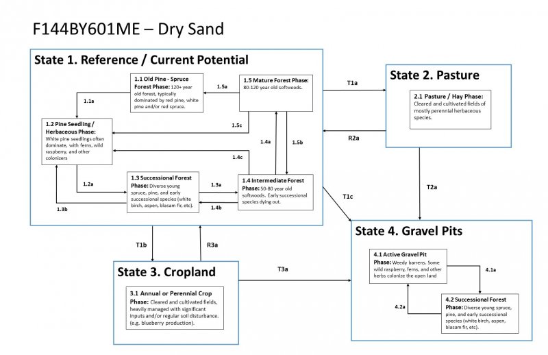
State and transition model
More interactive model formats are also available.
View Interactive Models
More interactive model formats are also available.
View Interactive Models
Click on state and transition labels to scroll to the respective text
State 1 submodel, plant communities
Communities 1, 5 and 2 (additional pathways)
State 2 submodel, plant communities
State 3 submodel, plant communities
State 4 submodel, plant communities
State 1
Reference/ Current Potential
Community 1.1
Old Pine - Spruce Forest Phase: 120+Yrs
120+ year old forest, typically dominated by red pine, white pine and/or red spruce.
Dominant plant species
-
eastern white pine (Pinus strobus), tree
-
red spruce (Picea rubens), tree
Community 1.2
Pine Seedling/ Herbaceous Phase
White pine seedlings often dominate, with ferns, wild raspberry, and other colonizers.
Dominant plant species
-
eastern white pine (Pinus strobus), tree
Community 1.3
Successional Forest Phase
Diverse young spruce, pine, birch, aspen, etc.
Community 1.4
Intermediate Forest Phase: 50 - 80 yrs
50-80 year old softwoods. Early successional species dying out.
Community 1.5
Mature Forest Phase: 80 - 120 yrs
80-120 year old hardwoods and softwoods.
Pathway P1.1-1.2
Community 1.1 to 1.2
clearcutting, blowdown, fire
Pathway P1.2-1.3
Community 1.2 to 1.3
vegetation development (succession)
Pathway P1.3-1.2
Community 1.3 to 1.2
selective cutting, forest management
Conservation practices
| Forest Stand Improvement | |
|---|---|
| Forest Land Management | |
| Forest Management Plan - Written | |
| Forest Management Plan - Applied |
Pathway P1.3-1.4
Community 1.3 to 1.4
vegetation development (succession)
Pathway P1.4-1.2
Community 1.4 to 1.2
selective cutting, forest management
Conservation practices
| Forest Stand Improvement | |
|---|---|
| Forest Land Management | |
| Forest Management Plan - Written | |
| Forest Management Plan - Applied |
Pathway P1.4-1.3
Community 1.4 to 1.3
selective cutting, forest management
Conservation practices
| Forest Stand Improvement | |
|---|---|
| Forest Land Management | |
| Forest Management Plan - Written | |
| Forest Management Plan - Applied |
Pathway P1.4-1.5
Community 1.4 to 1.5
vegetation development (succession)
Pathway P1.5-1.1
Community 1.5 to 1.1
cutting, logging, fire
Conservation practices
| Upland Wildlife Habitat Management | |
|---|---|
| Forest Trails and Landings | |
| Forest Stand Improvement | |
| Record Keeping | |
| Forest Land Management | |
| Forest Management Plan - Written | |
| Forest Management Plan - Applied | |
| Forest stand improvement for habitat and soil quality |
Pathway P1.5-1.2
Community 1.5 to 1.2
selective cutting, forest management
Pathway P1.5-1.4
Community 1.5 to 1.4
selective cutting thinning, forest management
Conservation practices
| Forest Stand Improvement | |
|---|---|
| Forest Land Management | |
| Forest Management Plan - Written | |
| Forest Management Plan - Applied |
State 2
Pasture
Community 2.1
Pasture/Hay Phase
Cleared and cultivated fields of mostly perennial herbaceous species.
State 3
Cropland
Cleared and cultivated fields, heavily managed with significant inputs and/or regular soil disturbance. (e.g. blueberry production).
Community 3.1
Annual or Perennial Crop Phase
: Cleared and cultivated fields, heavily managed with significant inputs and/or regular soil disturbance. (e.g. blueberry production).
State 4
Gravel Pits
Community 4.1
Active Gravel Pit Phase
Weedy barrens. Some wild raspberry, ferns, and other herbs colonize the open land
Community 4.2
Successional Forest Phase
Diverse young spruce, pine, and early successional species (white birch, aspen, blasam fir, etc).
Pathway P4.1-4.2
Community 4.1 to 4.2
abandonment, vegetation development (succession)
Conservation practices
| Tree/Shrub Site Preparation | |
|---|---|
| Tree/Shrub Establishment |
Pathway P4.2-4.1
Community 4.2 to 4.1
clearing and cutting
Conservation practices
| Clearing and Snagging | |
|---|---|
| Land Clearing |
Transition T1-2
State 1 to 2
Cutting and clearing, meadow/pasture establishment
Conservation practices
| Brush Management | |
|---|---|
| Clearing and Snagging | |
| Land Clearing | |
| Upland Wildlife Habitat Management | |
| Early Successional Habitat Development/Management | |
| Record Keeping | |
| Native Plant Community Restoration and Management | |
| Invasive Species Pest Management |
Transition T1-3
State 1 to 3
cutting and clearing, crop establishment
Conservation practices
| Clearing and Snagging | |
|---|---|
| Land Clearing | |
| Land Smoothing | |
| Record Keeping |
Transition T1-4
State 1 to 4
cutting and clearing, sand and gravel mining operations (excavation)
Conservation practices
| Clearing and Snagging | |
|---|---|
| Land Clearing | |
| Monitoring and Evaluation |
Restoration pathway R2-1
State 2 to 1
abandonment, vegetation development (succession), plantings
Conservation practices
| Brush Management | |
|---|---|
| Tree/Shrub Site Preparation | |
| Tree/Shrub Establishment | |
| Upland Wildlife Habitat Management | |
| Record Keeping | |
| Invasive Plant Species Control |
Transition T2-4
State 2 to 4
sand and gravel excavation
Conservation practices
| Land Clearing | |
|---|---|
| Monitoring and Evaluation |
Restoration pathway R3-1
State 3 to 1
abandonment, vegetation development (succession), plantings
Conservation practices
| Tree/Shrub Site Preparation | |
|---|---|
| Tree/Shrub Establishment | |
| Upland Wildlife Habitat Management | |
| Record Keeping | |
| Invasive Plant Species Control |
Transition T3-4
State 3 to 4
sand and gravel excavation
Conservation practices
| Land Clearing | |
|---|---|
| Monitoring and Evaluation |
Restoration pathway R4-1
State 4 to 1
forest re-establishment
Conservation practices
| Tree/Shrub Site Preparation | |
|---|---|
| Land Reclamation, Abandoned Mined Land | |
| Land Reclamation, Currently Mined Land | |
| Spoil Spreading | |
| Tree/Shrub Establishment | |
| Upland Wildlife Habitat Management | |
| Land Grading | |
| Record Keeping | |
| Restoration and Management of Natural Ecosystems | |
| Native Plant Community Restoration and Management | |
| Invasive Plant Species Control |
Additional community tables
Interpretations
Supporting information
Inventory data references
Future work is needed, as described in a future project plan, to validate the information presented in this provisional ecological site description. Future work includes field sampling, data collection and analysis by qualified vegetation ecologists and soil scientists. As warranted, annual reviews of the project plan can be conducted by the Ecological Site Technical Team. A final field review, peer review, quality control, and quality assurance reviews of the ESD are necessary to approve a final document.
Other references
Comer, P., D. Faber-Langendoen, R. Evans, S. Grawler, C. Josse, G. Kittel, S. Menard, M. Pyne, M. Reid, K. Schultz, K. Snow, and J. Teague. 2003. Ecological Systems of the United States: A Working Classification of U.S. Terrestrial Systems. NatureServe, Arlington, Virginia
Edinger, G. J., D. J. Evans, S. Gebauer, T. G. Howard, D. M. Hunt, and A. M. Olivero (editors). 2014. Ecological Communities of New York State. Second Edition. A revised and expanded edition of Carol Reschke’s Ecological Communities of New York State. New York Natural Heritage Program, New York State Department of Environmental Conservation, Albany, NY.
Gawler, S. and A. Cutko. 2010. Natural Landscapes of Maine: A Guide to Natural Communities and Ecosystems. Maine Natural Areas Program, Maine Department of Conservation, Augusta, Maine.
NatureServe. 2021. NatureServe Explorer: An online encyclopedia of life [web application]. NatureServe, Arlington, Virginia. https://explorer.natureserve.org/. (accessed 10 July. 2021).
Soil Survey Staff, Natural Resources Conservation Service, United States Department of Agriculture. 2006. Land Resource Regions and Major Land Resource Areas of the United States, the Caribbean, and the Pacific Basin. Agricultural Handbook 296
Soil Survey Staff, Natural Resources Conservation Service, United States Department of Agriculture. Official Soil Series Descriptions. Available online. (accessed 11 Aug. 2021).
Soil Survey Staff, Natural Resources Conservation Service, United States Department of Agriculture. Soil Climate Research Station Data. Available online. (accessed 23 June. 2021).
Soil Survey Staff, Natural Resources Conservation Service, United States Department of Agriculture. Soil Survey Geographic (SSURGO) Database for [MLRA 141, Maine]. Available online. (accessed 14 Oct. 2021).
Sperduto, D.D. and William F. Nichols. 2011. Natural Communities of New Hampshire. 2nd Ed. NH Natural Heritage Bureau, Concord, NH. Pub. UNH Cooperative Extension, Durham, NH.
Swain, P. C. 2020. Classification of the Natural Communities of Massachusetts. Massachusetts Division of Fisheries and Wildlife, Westborough, MA
USNVC [United States National Vegetation Classification]. 2017. United States National Vegetation Classification Database V2.01. Federal Geographic Data Committee, Vegetation Subcommittee, Washington DC. Available The U.S. National Vegetation Classification (usnvc.org) (accessed 2 July. 2021).
Contributors
Christopher Mann
Approval
Nels Barrett, 9/27/2024
Acknowledgments
Nels Barrett and Nick Butler provided considerable review of this ecological site concept.
Rangeland health reference sheet
Interpreting Indicators of Rangeland Health is a qualitative assessment protocol used to determine ecosystem condition based on benchmark characteristics described in the Reference Sheet. A suite of 17 (or more) indicators are typically considered in an assessment. The ecological site(s) representative of an assessment location must be known prior to applying the protocol and must be verified based on soils and climate. Current plant community cannot be used to identify the ecological site.
| Author(s)/participant(s) | |
|---|---|
| Contact for lead author | |
| Date | 06/29/2020 |
| Approved by | Nels Barrett |
| Approval date | |
| Composition (Indicators 10 and 12) based on | Annual Production |
Indicators
-
Number and extent of rills:
-
Presence of water flow patterns:
-
Number and height of erosional pedestals or terracettes:
-
Bare ground from Ecological Site Description or other studies (rock, litter, lichen, moss, plant canopy are not bare ground):
-
Number of gullies and erosion associated with gullies:
-
Extent of wind scoured, blowouts and/or depositional areas:
-
Amount of litter movement (describe size and distance expected to travel):
-
Soil surface (top few mm) resistance to erosion (stability values are averages - most sites will show a range of values):
-
Soil surface structure and SOM content (include type of structure and A-horizon color and thickness):
-
Effect of community phase composition (relative proportion of different functional groups) and spatial distribution on infiltration and runoff:
-
Presence and thickness of compaction layer (usually none; describe soil profile features which may be mistaken for compaction on this site):
-
Functional/Structural Groups (list in order of descending dominance by above-ground annual-production or live foliar cover using symbols: >>, >, = to indicate much greater than, greater than, and equal to):
Dominant:
Sub-dominant:
Other:
Additional:
-
Amount of plant mortality and decadence (include which functional groups are expected to show mortality or decadence):
-
Average percent litter cover (%) and depth ( in):
-
Expected annual annual-production (this is TOTAL above-ground annual-production, not just forage annual-production):
-
Potential invasive (including noxious) species (native and non-native). List species which BOTH characterize degraded states and have the potential to become a dominant or co-dominant species on the ecological site if their future establishment and growth is not actively controlled by management interventions. Species that become dominant for only one to several years (e.g., short-term response to drought or wildfire) are not invasive plants. Note that unlike other indicators, we are describing what is NOT expected in the reference state for the ecological site:
-
Perennial plant reproductive capability:
Print Options
Sections
Font
Other
The Ecosystem Dynamics Interpretive Tool is an information system framework developed by the USDA-ARS Jornada Experimental Range, USDA Natural Resources Conservation Service, and New Mexico State University.
Click on box and path labels to scroll to the respective text.