Natural Resources
Conservation Service
Ecological site F145XY003CT
Very Wet Inland Lake Plain
Last updated: 9/27/2024
Accessed: 04/10/2026
General information
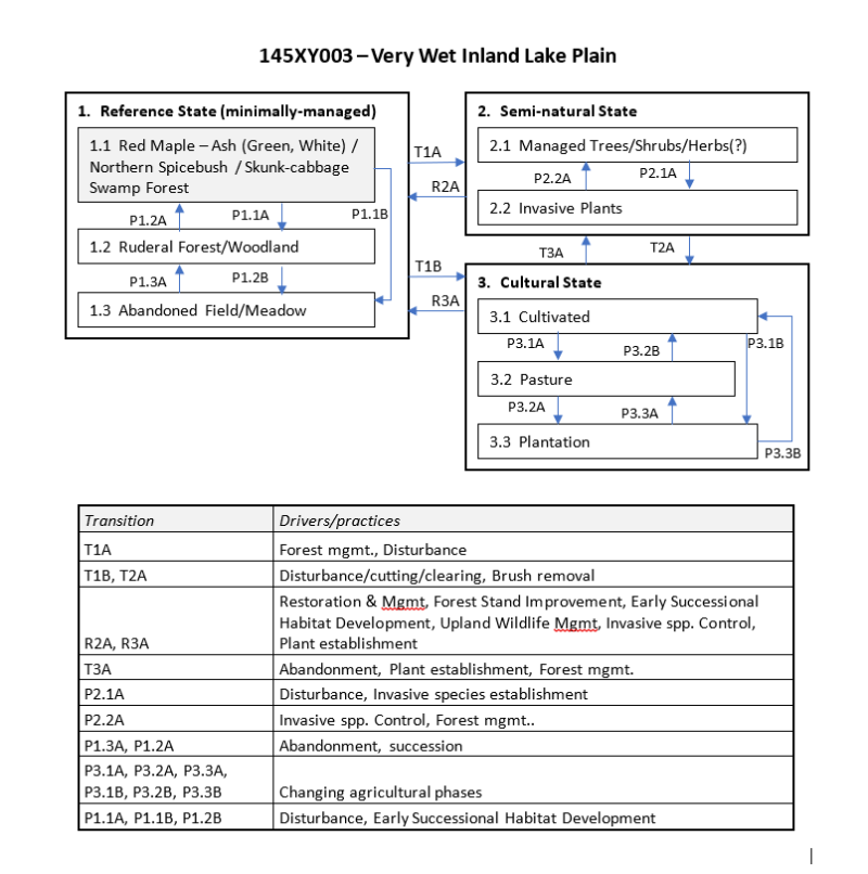
Provisional. A provisional ecological site description has undergone quality control and quality assurance review. It contains a working state and transition model and enough information to identify the ecological site.
MLRA notes
Major Land Resource Area (MLRA): 145X–Connecticut Valley
Major Land Resource Area (MLRA): 145 – Connecticut Valley (USDA-NRCS, 2006).
The nearly level floor of the Connecticut Valley makes up most of the area. Nearly level to sloping lowlands are at the outer edges of the river valley. These lowlands are broken by isolated, north- to south-trending trap-rock ridges that are hilly and steep. Elevation ranges from sea level to 100 meters (330 feet) in the lowlands and from 50 to 100 meters (650 to 1,000 feet) on ridges. The geology of this rift valley is a late Triassic and early Jurassic sandstone, shale, and conglomerate sequence. Tilted basalt flows along rift zones form the trap rock ridges exhibiting the greatest landscape relief. Glaciation accounts for glacial lake deposits, outwash, and till. Following glacial retreat, wind-deposited loess caps some areas. Recent alluvium deposits form well-developed flood plain along the Connecticut River. These deposits created some of the most productive agricultural soils in New England. The dominant soils are entisols and inceptisols with a mesic temperature regime in combination with parent materials such as glacial lakebeds, glacial outwash, glacial till, and recent alluvium. From north-to-south within the Connecticut Valley, the climate transitions from humid-continental to humid temperate with pronounced seasons and frequent storms. The forests are predominately central hardwoods to the south and transition hardwoods to the north. Significant habitats include trap rock ridges, sandplains, and floodplains of the Connecticut River and major tributaries. Much of the area is currently in residential and urban development and agriculture. While much of the areas is also forested, habitat loss and fragmentation are widespread throughout the Connecticut Valley
Classification relationships
USDA-NRCS (USDA, 2006):
Land Resource Region (LRR): R – Northeastern Forage and Forest Region
Major Land Resource Area (MLRA): 145 – Connecticut Valley
USDA-FS (Cleland et al, 2007):
Province: 221 – Eastern Broadleaf Forest
Section: 221A – Lower New England
Subsection: 221Af –Lower Connecticut River Valley
Province: M211 – Adirondack New England Mixed Forest – Coniferous Forest – Alpine Meadow (in part)
Section: M211B– New England Piedmont (in part)
Subsection: 211Bb – Southern Piedmont (in part)
Ecological site concept
The Ver Wet Inland Lake Plain ecological site consists of deep, very poorly drained silty clayey soils formed in glacio-lacustrine sediments and occupy bottomlands and basins. Geographically, these areas were once occupied by former glacial Lake Hitchcock in MA and northcentral CT, as well other former glacial lakes within the CT valley. Representative soil is Maybid derived from inland glaciolacustrine parent materials. The vegetation is often a mosaic of forest, woodland, shrub land, and herbaceous communities. The reference forest community is typified by a red maple – hardwoods swamp forest. These sites may be influenced by seasonal flooding and high water tables or seepage and maybe considered minerotrophic (slightly enriched).
Associated sites
| F145XY004CT |
Wet Lake Plain |
|---|
Similar sites
| F145XY006CT |
Semi-Rich Moist Lake Plain |
|---|---|
| F145XY007MA |
Well Drained Lake Plain |
Table 1. Dominant plant species
| Tree |
(1) Acer rubrum |
|---|---|
| Shrub |
(1) Vaccinium corymbosum |
| Herbaceous |
(1) Symplocarpus foetidus |
Click on box and path labels to scroll to the respective text.