Natural Resources
Conservation Service
Ecological site F145XY013CT
Well Drained Till Uplands
Last updated: 9/27/2024
Accessed: 04/27/2025
General information
Provisional. A provisional ecological site description has undergone quality control and quality assurance review. It contains a working state and transition model and enough information to identify the ecological site.
MLRA notes
Major Land Resource Area (MLRA): 145X–Connecticut Valley
The nearly level floor of the Connecticut River Valley makes up most of the area. Nearly level to sloping lowlands are at the outer edges of the river valley. These lowlands are broken by isolated, north- to south-trending trap-rock ridges that are hilly and steep. Elevation ranges from sea level to 330 feet in the lowlands and from 650 to 1,000 feet on ridges.
Recent alluvium has been deposited on the nearly level flood plain along the Connecticut River since the glacial retreat about 10,000 to 12,000 years ago. These deposits created some of the most productive agricultural soils in New England. Glacial lake deposits, outwash, and recent alluvial deposits dominate.
The area primarily supports central hardwoods. Habitat loss and fragmentation are widespread throughout the lower part of the Connecticut River Valley. The major tree species in the rest of the forested areas are sugar maple, birch,beech, oaks, and hickory. White pine and hemlock are the dominant conifers, but pitch pine and red pine are more common on sandy soils. Red maple grows on the wetter sites.
The most common understory plants are moosewood and hobblebush in the northern part of the area and dogwood in the southern part. Abandoned agricultural land is dominated by white pine and paper birch in the northern part and red cedar and gray birch in the southern part. The important upland habitats include trap-rock ridges and sand plains. Oak woodlands and cedar glades are common on the ridges. Black oak savannas mixed with pitch pine and varying amounts of little bluestem are common on the sand plains. Other habitats of significance include wetlands associated with the Connecticut River freshwater marshes, swamps, flood plains, and lowlands. The dominant trees on the flood plains are black willow, cottonwood, and sycamore.
Classification relationships
USDA-NRCS (USDA, 2006):
Land Resource Region (LRR): R – Northeastern Forage and Forest Region
Major Land Resource Area (MLRA): 145 – Connecticut Valley
USDA-FS (Cleland et al, 2007):
Province: 221 – Eastern Broadleaf Forest
Section: 221A – Lower New England
Subsection: 221Af –Lower Connecticut River Valley
Province: M211 – Adirondack New England Mixed Forest – Coniferous Forest – Alpine
Meadow (in part)
Section: M211B– New England Piedmont (in part)
Subsection: 211Bb – Southern Piedmont (in part)
Ecological site concept
The Well-Drained Till Uplands ecological site consists of well drained, loamy soils formed in ablation till derived mostly from basalt and or sandstone and shale, but occasionally gneiss and schist. The soils are moderately deep and deep to bedrock. They are nearly level to moderately steep soils on hills and ridges. Representative soils are Cheshire and Yalesville, and may occasionally include Cardigan, Dutchess, Narragansett, Watchaug, and Wapping. Representative plant communities are typically dominated by an oak-hickory (Quercus spp. – Carya spp.) dominated forest.
Associated sites
| F145XY011CT |
Well Drained Shallow Till Uplands |
|---|
Similar sites
| F145XY012CT |
Well Drained Dense Till Uplands |
|---|---|
| F145XY014CT |
Moist Dense Till Uplands |
Table 1. Dominant plant species
| Tree |
(1) Quercus rubra |
|---|---|
| Shrub |
(1) Hamamelis virginiana |
| Herbaceous |
(1) Carex pensylvanica |
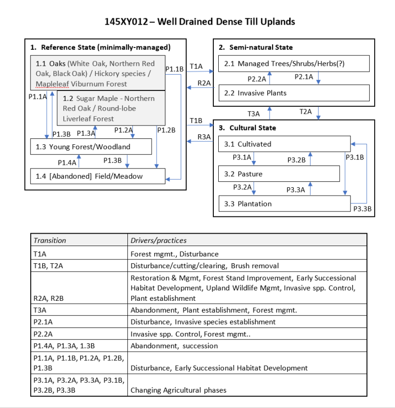
Click on box and path labels to scroll to the respective text.
