Natural Resources
Conservation Service
Ecological site R151XY673TX
INTERMEDIATE Firm MARSH
Last updated: 3/24/2025
Accessed: 02/08/2026
General information
Provisional. A provisional ecological site description has undergone quality control and quality assurance review. It contains a working state and transition model and enough information to identify the ecological site.

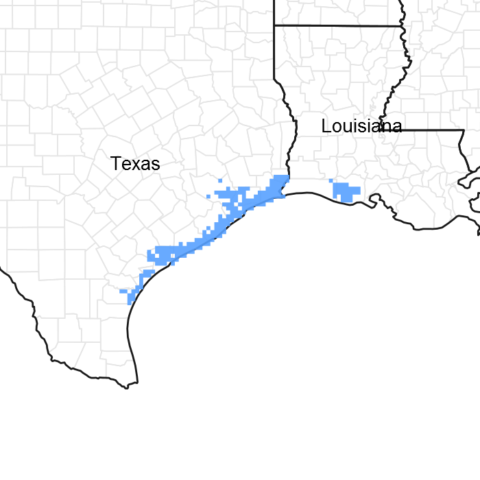
Figure 1. Mapped extent
Areas shown in blue indicate the maximum mapped extent of this ecological site. Other ecological sites likely occur within the highlighted areas. It is also possible for this ecological site to occur outside of highlighted areas if detailed soil survey has not been completed or recently updated.
MLRA notes
Major Land Resource Area (MLRA): 151X–Gulf Coast Marsh
Major land resource area (MLRA)151, Gulf Coast Marsh, is in Louisiana (95 percent), Texas (4 percent), and Mississippi (1 percent). It makes up about 8,495 square miles (22,015 square kilometers). The towns of Gretna, Chalmette, and Marrero, Louisiana, and the city of New Orleans, Louisiana, are in the eastern part of this MLRA. The town of Port Arthur, Texas, is in the western part. Interstate 10 and U.S. Highway 90 cross the area. The New Orleans Naval Air Station is in this MLRA. Fort Jackson, overlooking the mouth of the Mississippi River, and the Jean Lafitte National Historic Park and Preserve are in the MLRA. A number of national wildlife refuges and State parks occur throughout this area. MLRA 151 is a very complex ecosystem with active deltaic development and subsidence with extreme anthropogenic impact by man with construction of flood protection levees and channelization occurring on the eastern portion of the MLRA. The Western portion of the MLRA is more stable in that portions of the landscape is protected naturally by the Chenier's, although there is Anthropogenic affects of the interior due to channelization for navigation.
Classification relationships
Major Land Resource Area (MLRA) and Land Resource Unit (LRU) (USDA-Natural Resources Conservation Service, 2006)
The Natural Communities of Louisiana - (Louisiana Natural Heritage Program - Louisiana Department of Wildlife and Fisheries)
Ecological site concept
The central concept of this site is somewhat isolated from salt water intrusion. The salinity ranges are never high but there is some salinity in the soil that will manifest itself during periods of dry weather. The best indicator plant on this site is seashore Paspalum. Lesser amounts of California bulrush, Olney bulrush, softstem bulrush, marshhay cordgrass, spikesedges, seedbox, Colorado River hemp, and cattails are also found. Elevation, drainage, salinity, water depth, and duration play a major role in the vegetation. Small areas of open water are also included. These areas are important to waterfowl and other wildlife because habitat diversity. Water salinity level varies throughout the year. Fresher water is indicated by the presence of narrowleaf cattail, seedbox, whorled pennywort, and softstem bulrush.
Associated sites
| R151XY676TX |
INTERMEDIATE Fluid MARSH Intermediate Fluid Marsh is more Fluid than the intermediate Firm Marsh Site, similar plant communities. |
|---|
Similar sites
| R151XY009LA |
Fresh Firm Mineral Marsh 60-64 PZ The Fresh Firm Marsh Site is similar in landscape position but the salinity range of the Intermediate Firm Site is higher, therefore the species composition and production will be less. |
|---|---|
| R151XY005LA |
Brackish Firm Mineral Marsh 55-64 PZ The Brackish Firm Marsh Site is similar in landscape position but the salinity range of the Intermediate Firm Site is lower, therefore the species composition and production will be more. |
Table 1. Dominant plant species
| Tree |
Not specified |
|---|---|
| Shrub |
Not specified |
| Herbaceous |
Not specified |
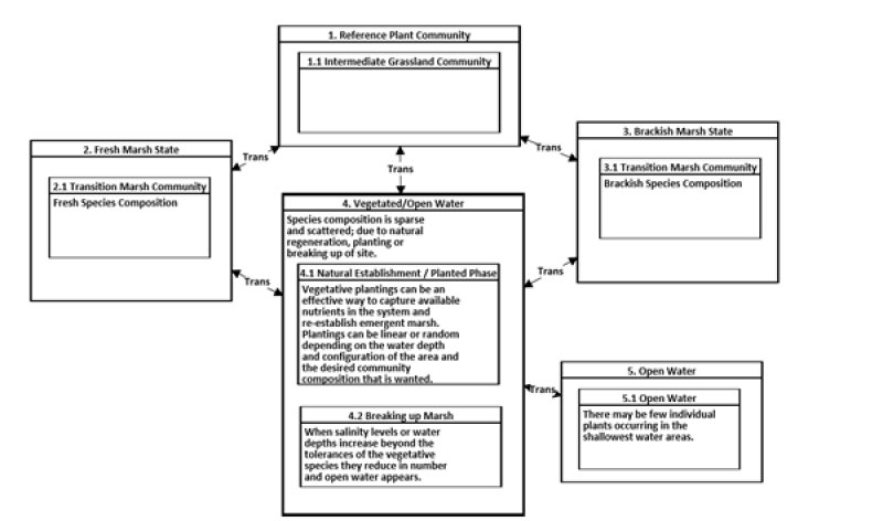
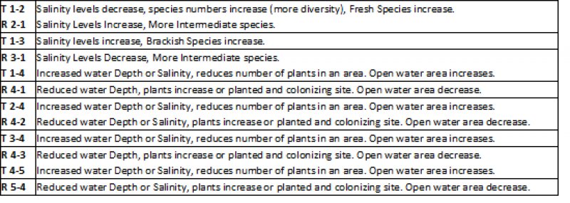
Click on box and path labels to scroll to the respective text.

