Ecological dynamics
The most dominant ecological drivers on this site are hydrology, depth of organic soil, extreme weather, salinization, and fire. Although it is regulated today, artificial drainage has been extensively applied to manage this site. Once applied, the effects of drainage are persistent. Historically, the use of fire by indigenous civilizations may have also been extensive. Some limited wildfire and prescribed fire occur today, but fire suppression has been the norm since the 20th century. Both fire and drainage can impact depth of organic soil.
Persistent and prolonged saturation slows decomposition and allows for the accumulation of organic soil material. Eventually, organic soil materials accumulate to depths great enough that tree roots are no longer able to reach the relatively nutrient rich mineral soil substrate, and the stature of the woody vegetation becomes diminished. In areas where seasonal drying is greater, organic soil materials do not accumulate to such great depths, tree roots are able to reach mineral substrate, and tree stature increases. Drainage of these sites will lower the water table and increase drying of the surface. However, the exposure of organic soils to oxygen will increase organic material decomposition, will decrease organic material thickness, and will ultimately lower the soil surface elevation.
Locations with seasonally drier soils may be more prone to fire, which may also reduce the thickness of the organic soil by consuming it as fuel when dry. Intense fire during drought may consume enough organic soil material to create new open water or marsh areas when the water table returns. The variety of vegetation communities that historically occur on this site are representative of a variety of strategies to adapt to historical fire return intervals. For example, pond pine and Atlantic white cedar are well adapted to stand replacement fire, while bay woodlands are well suited to thrive on this site only in the prolonged absence of fire. (Ashe et al.,1983; FNAI, 2010)
Hurricanes produce winds and rain that can have significant impact. Organic soils decrease the rooting strength of trees and make them more susceptible to windfall. Extreme precipitation can increase and prolong inundation and saturation. The lack of hydrologic gradient between these sites and sea level can further increase and prolong inundation and saturation following an extreme precipitation event.
In this MLRA, intrusion of salt water into the soil profile can have significant impacts on vegetation. Low lying areas dominated by organic soils are at particularly high risk of salinization. Organic soils tend to retain salts more effectively than mineral soils. The organic material has a higher cation exchange capacity and more of the salts are bound to the soil than in a mineral soil. In forested areas, this phenomenon is sufficiently common that ghost forests are increasingly recognized as a widespread example of the impacts of sea level rise and salinization. Extensive ditching across this MLRA increases exposure of the landscape to salinization. As sea level rises, a dense salt-water wedge moves further inland up these ditches exposing more of the landscape to these processes.
In the State and Transition Model below for this site where soils meet hydric criteria, hydrologically driven transitions represent both changes in conditions across space as well as changes in conditions over time. Ideally, transitions would represent only changes over time. As updates to the soil survey allow, individual states within this site may be split into individual distinct sites.
If following the soil survey has brought you to this ESD, but you find yourself in a graminoid marsh community, please refer to the ESD titled Tidal Marsh on Organic Soil, R153BY140NC. Some of the same soils mapped on this ecological site are also mapped on marsh locations, but the complexity of salinity and tidal dynamics make it necessary to describe the marsh systems in a separate ESD.
State 1
Shrub Bog
Shrub bog is found on the edge of swamps, in stream head drainage seeps, and on flat, poorly drained divides between rivers. Shrub bogs occur in areas of poor internal drainage that typically have highly developed organic soils.
Community dynamics are driven by hydrology, especially hydroperiod, accumulation of organic soils, and periodic fire. This site has a long hydroperiod with the water table at or near the soil surface 6 to 12 months of the year. Periodic low intensity surface fire impacts species composition and productivity, but intense fire during droughty conditions can consume significant volumes of organic soil. Periodic low intensity surface fires favor pond pine, but the absence of fire favors bay hardwoods and slash pine. Intense fire can significantly lower soil surface elevation and may cause a state transition with prolonged periods of inundation.
(FNAI, 2010; Schafale et al., 1990; Sharitz et al., 1982)
Community 1.1
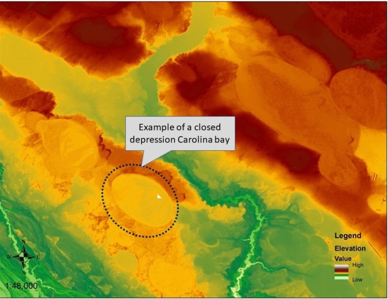
Raised Bog Depression
Shrub bog consists of dense stands of broadleaved evergreen shrubs and vines, with or without an overstory of scattered pine or bay trees, growing in raised mucky soil on a depression. The sponge-like characteristics of a broad expanse of a raised organic soil profile holds the water table at or very near the surface for extended periods of time without creating substantial ponding. These sites may be saturated nearly year around. Their hydrology is quite unique.
Shrub bog is found on the edge of swamps, in stream head drainage seeps, and on flat, poorly drained divides between rivers. Raised bog conditions describe the end-point of ecological succession in these communities when the accumulation of woody organic materials develop deep peaty soils. Thick organic soils limit the access of tree roots to the more nutrient rich mineral soils buried beneath the organics. Tree stature and canopy cover become diminished.
Raised bogs on depressions are handled separately from pocosins which are found specifically on flats. They are treated separately for proper understanding and management of hydrology. Raised bogs in depressions are hydrologically distinct from pocosin flats, because a depression holds more water on the bog for longer hydroperiods. With longer hydroperiods, organic soils more easily accumulate to deeper depths. Depressional hydrology facilitates the prolonged hydroperiod necessary to accumulate sufficient organic material to raise the soil surface above the surrounding mineral soil surface. The results are similar, but the hydrology of a depression is much more facilitative than a flat on an interstream divide. Depressional hydrology facilitates this process much more effectively than flat hydrology.
Dominant plant species
-
pond pine (Pinus serotina), tree
-
loblolly bay (Gordonia lasianthus), tree
-
sweetbay (Magnolia virginiana), tree
-
fetterbush lyonia (Lyonia lucida), shrub
-
swamp titi (Cyrilla racemiflora), shrub
-
wax myrtle (Morella cerifera), shrub
-
inkberry (Ilex glabra), shrub
-
coastal sweetpepperbush (Clethra alnifolia), shrub
-
laurel greenbrier (Smilax laurifolia), shrub
-
coral greenbrier (Smilax walteri), shrub
-
giant cane (Arundinaria gigantea), grass
-
Virginia chainfern (Woodwardia virginica), other herbaceous
-
sphagnum (Sphagnum), other herbaceous
-
pitcherplant (Sarracenia), other herbaceous
-
Walter's sedge (Carex striata), other herbaceous
Community 1.2
Pocosin Flat
Pocosin consists of dense stands of broadleaved evergreen shrubs and vines, with or without an overstory of scattered pine or bay trees, growing in raised mucky soil on a flat or talf. The sponge-like characteristics of a broad expanse of a raised organic soil profile, characteristic of a pocosin, holds the water table at or very near the surface for extended periods of time without creating substantial ponding. These sites may be saturated nearly year around. Their hydrology is quite unique. By virtue of its position on interstream flats, supersaturated pocosin soils may be the source of surface water flows as water leaks out of the organic soil sponge in a slow sheet flow across the shallow organic and mineral soils at the margins of the raised organic soils.
Some naturalists distinguish a “high pocosin” from a “low pocosin” by the stature of the woody cover. High pocosin being dominated by a forest overstory taller than 6 meters, while low pocosin refers to a more shrub-scrub woodland cover less than 6 meters tall. The distinction between the two is the thickness of the organic soil layers, with low pocosin occurring on the thickest. Thicker organic soils limit the access of tree roots to the more nutrient rich mineral soils buried beneath the organics. Tree stature and canopy cover become diminished. Low pocosin is probably the end-point of successional development on pocosin landforms.
Raised bogs on depressions are handled separately from pocosins which are found specifically on flats. They are treated separately for proper understanding and management of hydrology. Raised bogs in depressions are hydrologically distinct from pocosin flats, because a depression holds more water on the bog for longer hydroperiods. With longer hydroperiods, organic soils more easily accumulate to deeper depths. Depressional hydrology facilitates the prolonged hydroperiod necessary to accumulate sufficient organic material to raise the soil surface above the surrounding mineral soil surface. The results are similar, but the hydrology of a depression is much more facilitative than a flat on an interstream divide. Depressional hydrology facilitates this process much more effectively than flat hydrology.
(FNAI, 2010; Schafale et al., 1990; Sharitz et al., 1982)
Dominant plant species
-
pond pine (Pinus serotina), tree
-
loblolly bay (Gordonia lasianthus), tree
-
sweetbay (Magnolia virginiana), tree
-
fetterbush lyonia (Lyonia lucida), shrub
-
swamp titi (Cyrilla racemiflora), shrub
-
wax myrtle (Morella cerifera), shrub
-
inkberry (Ilex glabra), shrub
-
coastal sweetpepperbush (Clethra alnifolia), shrub
-
laurel greenbrier (Smilax laurifolia), shrub
-
coral greenbrier (Smilax walteri), shrub
-
giant cane (Arundinaria gigantea), grass
-
Virginia chainfern (Woodwardia virginica), other herbaceous
-
sphagnum (Sphagnum), other herbaceous
-
pitcherplant (Sarracenia), other herbaceous
-
Walter's sedge (Carex striata), other herbaceous
State 2
Nonriverine Swamp Woodlands
Community 2.1
Pond Pine Woodland
Pond pine woodlands tend to occur on shallower organic soils and can occur on the outer perimeter of a raised bog or domed pocosin. Pond pine woodlands persist well and increasingly dominate this site type in the presence of periodic fire. Bay woodlands and pond pine woodlands are believed to be hydrologically very similar with fire dynamics driving the difference. Pond pine withstands low intensity fire well as it sprouts from epicormic buds. The serotinous cones of pond pine also enable it to reoccupy a site quickly after catastrophic fire.
(FNAI, 2010; Nelson, 1986; Schafale et al., 1990; Sharitz et al., 1982)
Dominant plant species
-
pond pine (Pinus serotina), tree
-
loblolly bay (Gordonia lasianthus), tree
-
sweetbay (Magnolia virginiana), tree
-
red maple (Acer rubrum), tree
-
swamp bay (Persea palustris), tree
-
swamp titi (Cyrilla racemiflora), shrub
-
fetterbush lyonia (Lyonia lucida), shrub
-
maleberry (Lyonia ligustrina), shrub
-
large gallberry (Ilex coriacea), shrub
-
inkberry (Ilex glabra), shrub
-
coastal sweetpepperbush (Clethra alnifolia), shrub
-
laurel greenbrier (Smilax laurifolia), shrub
-
wax myrtle (Morella cerifera), shrub
-
giant cane (Arundinaria gigantea), grass
-
Virginia chainfern (Woodwardia virginica), other herbaceous
-
sphagnum (Sphagnum), other herbaceous
Community 2.2
Bay Woodland (Baygall)
Bay woodland communities tend to occur on shallower organic soils and can occur on the outer perimeter of a raised bog or domed pocosin. Bay woodlands persist well and increasingly dominate this site type in the long term absence of fire. Bay woodlands and pond pine woodlands are believed to be hydrologically very similar with fire dynamics driving the difference. Bay species sprout after low-intensity surface fire, but increasing bay abundance will increase fire intensity. Fires can be expected to be intense in the dense vegetation of a bay woodland, and bay trees do not typically survive high intensity fire.
(FNAI, 2010; Nelson, 1986; Schafale et al., 1990; Sharitz et al., 1982)
Dominant plant species
-
loblolly bay (Gordonia lasianthus), tree
-
sweetbay (Magnolia virginiana), tree
-
swamp bay (Persea palustris), tree
-
red maple (Acer rubrum), tree
-
fetterbush lyonia (Lyonia lucida), shrub
-
large gallberry (Ilex coriacea), shrub
-
swamp titi (Cyrilla racemiflora), shrub
-
wax myrtle (Morella cerifera), shrub
-
coastal doghobble (Leucothoe axillaris), shrub
-
swamp doghobble (Eubotrys racemosus), shrub
-
dahoon (Ilex cassine), shrub
-
Virginia sweetspire (Itea virginica), shrub
-
laurel greenbrier (Smilax laurifolia), shrub
-
coral greenbrier (Smilax walteri), shrub
-
sphagnum (Sphagnum), other herbaceous
State 2.3
Atlantic White Cedar Bog
Dense even aged stands of Atlantic white cedar can establish on deep organic soils following stand replacement fire. Often, they develop following a stand replacement fire that consumes soil and raises the water table. Atlantic white cedar bogs are found on peatlands and in other depressions, swales, or seepages with organic deposits. Cedar is not tolerant of fire, so it will not do well under conditions of periodic low intensity surface fire that is relatively common for many communities of this site. It is also shade intolerant so will only thrive in canopy openings. Loblolly pine is a common overstory associate in these communities. Atlantic white cedar bogs are relatively uncommon.
(Nelson, 1986; Schafale et al., 1990; Sharitz et al., 1982)
Dominant plant species
-
Atlantic white cedar (Chamaecyparis thyoides), tree
-
red maple (Acer rubrum), tree
-
fetterbush lyonia (Lyonia lucida), shrub
-
loblolly bay (Gordonia lasianthus), shrub
-
swamp titi (Cyrilla racemiflora), shrub
-
wax myrtle (Morella cerifera), shrub
-
sweetbay (Magnolia virginiana), shrub
-
inkberry (Ilex glabra), shrub
-
swamp bay (Persea palustris), shrub
-
redbay (Persea borbonia), shrub
State 2.4
Cypress - Gum - Tupelo Swamp
A nonriverine Cypress - Gum - Tupelo swamp is typically a basin wetland vegetated with hydrophytic trees and shrubs that can withstand an extended hydroperiod. These swamps are highly variable in size, shape, and species composition. Historically, these sites were once more strongly dominated by large trees, particularly bald cypress. Small stands of large virgin cypress in nonriverine swamp environments still persist today, but logging has reduced most stands to relatively small sized gum and red maple trees, often with dense shrubs. Depending on the hydrology and fire history, shrubs may be found throughout a basin swamp or they may be concentrated around the perimeter.
Historically, fires were probably rare, but might have occurred in drought periods. Stand killing fires under certain circumstances may have led to development of Atlantic white cedar bog communities. Areas susceptible to more frequent fire probably supported shrub bog communities rather than swamp. It seems likely that most Nonriverine Swamp Forests occur primarily in environments which have more nutrient influx than bogs or are more permanently wet and are protected from fire.
(FNAI, 2010; Nelson, 1986; Schafale et al., 1990)
Dominant plant species
-
bald cypress (Taxodium distichum), tree
-
pond cypress (Taxodium ascendens), tree
-
swamp tupelo (Nyssa biflora), tree
-
water tupelo (Nyssa aquatica), tree
-
red maple (Acer rubrum), tree
-
laurel oak (Quercus laurifolia), tree
-
water oak (Quercus nigra), tree
-
sweetbay (Magnolia virginiana), shrub
-
swamp bay (Persea palustris), shrub
-
swamp titi (Cyrilla racemiflora), shrub
-
fetterbush lyonia (Lyonia lucida), shrub
-
coastal sweetpepperbush (Clethra alnifolia), shrub
-
dahoon (Ilex cassine), shrub
-
wax myrtle (Morella cerifera), shrub
-
common buttonbush (Cephalanthus occidentalis), shrub
-
laurel greenbrier (Smilax laurifolia), shrub
-
coral greenbrier (Smilax walteri), shrub
-
maidencane (Panicum hemitomon), grass
-
chainfern (Woodwardia), other herbaceous
-
sphagnum (Sphagnum), other herbaceous
-
arrowhead (Sagittaria), other herbaceous
-
lizard's tail (Saururus cernuus), other herbaceous
-
smallspike false nettle (Boehmeria cylindrica), other herbaceous
-
beaksedge (Rhynchospora), other herbaceous
-
bladderwort (Utricularia), other herbaceous
-
royal fern (Osmunda regalis), other herbaceous
-
Walter's sedge (Carex striata), other herbaceous
Pathway 2.1.2
Community 2.1 to 2.2
Fire suppression
Pathway 2.1.3
Community 2.1 to 2.3
Stand replacement fire with nearby Atlantic white cedar seed source
Context dependence. This transition is probably uncommon, because stand replacement fire will also benefit pond pine.
Pathway 2.1.4
Community 2.1 to 2.4
Fire suppression and increased inundation
Pathway 2.2.1
Community 2.2 to 2.1
Periodic fire
Pathway 2.2.3
Community 2.2 to 2.3
Stand replacement fire with nearby Atlantic white cedar seed source
Pathway 2.2.4
Community 2.2 to 2.4
Increased inundation
Pathway 2.3.1
Community 2.3 to 2.1
Periodic fire
Pathway 2.3.2
Community 2.3 to 2.2
Undisturbed succession
Pathway 2.3.4
Community 2.3 to 2.4
Undisturbed succession and increased inundation.
Pathway 2.4.1
Community 2.4 to 2.1
Periodic fire and decreased inundation from some natural change to local hydrology.
Pathway 2.4.2
Community 2.4 to 2.2
Decreased inundation and undisturbed succession. Decreased inundation from some natural change to local hydrology.
Pathway 2.4.3
Community 2.4 to 2.3
Stand replacement fire with nearby Atlantic white cedar seed source and decreased inundation. Decreased inundation from some natural change to local hydrology.
State 3
Drained
This is a relatively wet site within a landscape with a persistent and nearly ubiquitous shallow water table across the MLRA. Historically, these sites have been drained frequently to support a variety of land uses including forestry, agriculture, and development. This drained state is included in this STM because this state exists widely today across the landscape. Drainage of wetlands today is significantly regulated. NRCS is required to consider impacts to wetlands according to Federal laws including, but not limited to, the Clean Water Act, the Wetland Conservation provisions of the Food Security Act of 1985, and State, Tribal, and local laws. It is the policy of NRCS to protect and promote wetland functions and values in all NRCS assistance (National Environmental Compliance Handbook (NECH) 610.36).
Community 3.1
Drained Forest
Forests are typically drained to facilitate timber production, especially artificial regeneration. The timber industry in the Southeast has artificially expanded the ecological footprint of Loblolly pine in particular.
Community 3.2
Cultivated Agriculture
Drainage is typically necessary on this site in order to establish cultivated agriculture.
Community 3.3
Managed Grassland
Lands drained in order to support pasture and/or hayland management.
Community 3.4
Urban Development
Lands developed to urban land use conditions.
Pathway 3.1.2
Community 3.1 to 3.2
Land clearing and cultivation
Pathway 3.1.3
Community 3.1 to 3.3
Land clearing and establishment of grassland
Pathway 3.1.4
Community 3.1 to 3.4
Land clearing and urban development
Pathway 3.2.1
Community 3.2 to 3.1
Establishment of trees. The timber industry in the Southeast has artificially expanded the ecological footprint of Loblolly pine in particular, mostly through significant site preparation during stand establishment.
Pathway 3.2.3
Community 3.2 to 3.3
Establishment of grassland
Pathway 3.2.4
Community 3.2 to 3.4
Urban development
Pathway 3.3.1
Community 3.3 to 3.1
Establishment of trees
Pathway 3.3.2
Community 3.3 to 3.2
Establishment of cultivation
Pathway 3.3.4
Community 3.3 to 3.4
Urban development
State 4
Restored
After land on this site has been drained, it is impossible to return fully to reference conditions that existed at that location prior to drainage, especially at locations that remained under active drainage management for long periods of time. Drained organic soils will have a lower soil surface elevation, and thinner organic horizons, than prior to drainage. Restoration efforts might include blocking and removing drainage structures, revegetation, and reintroduction of periodic fire, but redevelopment of organic soil surface elevations will take profoundly long periods of time to achieve, if ever.
Community 4.1
Restored Wet Histosol Flats and Depressions with Moderate Hydroperiods
This community represents restored wet histosol flats and depressions that experience moderate hydroperiods. The soils are saturated and inundated for much of the growing season. The longest saturation event within 30cm of the soil surface during the growing season ranges from 51 – 100 days. Prolonged periods of saturation and reduction reduces microbial decomposition rates, which allows for a significant amount of organic carbon to accumulate in the soils. Sites that have been restored for at least 20 years have facultative, facultative wet, and wetland obligate vegetation that dominate the community. The restored plant community composition is driven both by a species' ability to thrive in these conditions as well as whether or not it was planted at the restoration sites that were studied. (Moritz, 2021)
The species composition presented for this community reflects data collected at Carolina bay restoration locations in MLRA 153A. While there are important differences between these two MLRA, this information is still relevant in MLRA 153B where Histosols are more common.
Community 4.2
Restored Wet Histosol Flats and Depressions with Long Hydroperiods
This community represents restored wet histosol flats and depressions that experience long hydroperiods. The soils are saturated and inundated for much of the year. The longest saturation event within 30cm of the soil surface during the growing season ranges from 101 days to the entire growing season. Prolonged periods of saturation and reduction reduces microbial decomposition rates, which allows for more organic carbon to accumulate in the soils when compared to restored wet histosol flats and depressions that experience moderate hydroperiods. Sites that have been restored for at least 20 years have facultative wet, and wetland obligate vegetation that dominate the community. The restored plant community composition is driven by a species' ability to thrive in these conditions as well as whether or not it was planted at the restoration sites that were studied. (Moritz, 2021)
The species composition presented for this community reflects data collected at Carolina bay restoration locations in MLRA 153A. While there are important differences between these two MLRA, this information is still relevant in MLRA 153B where Histosols are more common.
Pathway 4.1.2
Community 4.1 to 4.2
Increased periods of saturation. The longest saturation event within 30cm of the soil surface during the growing season ranges from 101 days to the entire growing season.
Pathway 4.2.1
Community 4.2 to 4.1
Decreased periods of saturation. The longest saturation event within 30cm of the soil surface during the growing season ranges from 51 days to 100 days.
State 5
Salinized
Any community on this site that has become salinized by the impacts of salt water inundation or intrusion. Saltwater intrusion is the movement of saltwater into freshwater systems. The process occurs mostly by lateral flow into areas adjacent to coastal waters or ditch systems that connect saltwater bodies. These ditch systems are designed to drain freshwater off of a site, but sea level rise and extreme tidal events push saltwater up these ditch systems and expose more of the landscape to salinization processes. Salinization can also occur as storm surge and/or extreme high tides push saltwater flooding and inundation over the top of these terrestrial freshwater systems.
Community 5.1
Salinized Forest
The nature of a salinized forest depends on the level and persistence of salts in the soils. Forest vegetation impacts range from stunted vegetation to forests of standing dead trees. The unique “ghost forest” landform describes coastal organic forests subjected to permanent saltwater inundation from say sea level rise, resulting in loss of organics and die off of the woody species shifting the dominant vegetation to salt marsh.
Community 5.2
Salinized Cropland
Soil salinization converts once verdant farm fields to dead, bare soil areas.
Transition T1A
State 1 to 2
Decreased organic soil depth through either different fire dynamics or different hydrology.
Transition T1B
State 1 to 3
The drained state is included in this STM because this state exists widely today across the landscape. This transition is included to show how we got to where we are today. Drainage of wetlands today is significantly regulated. NRCS is required to consider impacts to wetlands according to Federal laws including, but not limited to, the Clean Water Act, the Wetland Conservation provisions of the Food Security Act of 1985, and State, Tribal, and local laws. It is the policy of NRCS to protect and promote wetland functions and values in all NRCS assistance (National Environmental Compliance Handbook (NECH) 610.36).
Transition T1C
State 1 to 5
Sea level rise, tidal inundation, and soil saltwater intrusion.
Transition T2A
State 2 to 1
Increased organic soil depth through changes in fire or changes in hydrology.
Transition T2B
State 2 to 3
The drained state is included in this STM because this state exists widely today across the landscape. This transition is included to show how we got to where we are today. Drainage of wetlands today is significantly regulated. NRCS is required to consider impacts to wetlands according to Federal laws including, but not limited to, the Clean Water Act, the Wetland Conservation provisions of the Food Security Act of 1985, and State, Tribal, and local laws. It is the policy of NRCS to protect and promote wetland functions and values in all NRCS assistance (National Environmental Compliance Handbook (NECH) 610.36).
Transition T2C
State 2 to 5
Sea level rise, tidal inundation, and soil saltwater intrusion.
Transition T3A
State 3 to 4
Remove, plug, or otherwise restore drainage, revegetate, and reintroduce periodic fire.
Transition T3B
State 3 to 5
Sea level rise, tidal inundation, and soil saltwater intrusion.
Transition T4A
State 4 to 5
Sea level rise, tidal inundation, and soil saltwater intrusion.