Natural Resources
Conservation Service
Ecological site VX161A01X009
Isothermic Ustic Naturalized Grassland
Last updated: 4/17/2025
Accessed: 03/27/2026
General information
Provisional. A provisional ecological site description has undergone quality control and quality assurance review. It contains a working state and transition model and enough information to identify the ecological site.
MLRA notes
Major Land Resource Area (MLRA): 161A–Lava Flows and Rock Outcrops
This MLRA occurs in the State of Hawaii on the Big Island of Hawaii and to a small extent on Maui. Elevation ranges from sea level to 13,796 feet (0 to 4,206 meters), which includes the tops of Mauna Kea, Mauna Loa, Haleakala, Kilauea, and Hualalai volcanoes. Slopes follow the undulating to very steep topography of the lava flows. The terrain includes barren lava flows, rocky cliffs, rock outcrops, and steep cinder cones. Lava flows are basaltic aa or pahoehoe lava. Average annual precipitation ranges from 10 to 100 inches (255 to 2,540 millimeters). Most of the rainfall occurs from October through March in most areas and from May through September in the Kona area of the Big Island. In Kona and isolated areas elsewhere, afternoon fog accumulation at higher elevations adds significant moisture by fog drip and ameliorates evapotranspiration. This effect is cut off sharply at the atmospheric inversion layer at about 6,000 feet (about 2,000 meters) elevation. Average annual air temperatures range from 38 to 76 degrees F (3 to 25 degrees C), with little seasonal variation. Freezing temperatures occur at the highest elevations. Dominant soils are Andisols and Histosols with isohyperthermic to isofrigid soil temperature regimes and ustic to udic soil moisture regimes. Large parts of the MLRA consist of miscellaneous (nonsoil) areas, including lava flows, rock outcrop, and cinder land. Native vegetation varies considerably as temperature, moisture, and soil development vary with elevation and flow age. In the driest areas near sea level, sparse, low-stature shrubs, grasses, and forbs predominate. Vegetation stature and density gradually increase with elevation to typical dry forest species such as lama, wiliwili, and alahee, koa-mamane-sandalwood or mamane-sandalwood forest, open ohia-lovegrass savanna, and finally sparse subalpine vegetation with silversword, shrubs, and grasses. Vegetation is extremely sparse at the highest elevations.
Classification relationships
This ecological site occurs within Major Land Resource Area (MLRA) 161A – Lava Flows and Rock Outcrops.
Ecological site concept
This ecological site occurs on the southeastern side of the island of Hawaii. Most of the ecological site is within Volcanoes National Park. Some is on private ranches.
The central concept of the Isothermic Ustic Naturalized Grassland is of well drained, very shallow to moderately deep soils formed in volcanic ash; most are in the Andisols soil order. Soil temperature regimes are isothermic; soil moisture regimes are ustic and, in some areas, ustic/udic intergrade or udic. Available water holding capacity is low due to ashy or sandy textures, high rock contents, shallow depths, and/or vitric (high volcanic glass content) mineralogy. Mean annual rainfall ranges from 40 to 80 inches (1000 to 2000 mm). Elevations range from 1000 to 4000 feet (310 to 1230 m).
Common introduced grass species are kikuyugrass (Cenchrus clandestinus), common velvetgrass (Holcus lanatus), rose Natal grass (Melinis repens), broomsedge bluestem (Andropogon virginicus), and thatching grass (Hyparrhenia rufa). Common native trees include koa (Acacia koa) and ohia lehua (Metrosideros polymorpha); common native shrubs include pukiawe (Styphelia tameiameiae syn. Leptocophylla tameiameiae), ulei (Osteomeles anthyllidifolia), and aalii (Dodonaea viscosa).
Associated sites
| VX161A01X008 |
Isohyperthermic Ustic Naturalized Grassland ISOHYPERTHERMIC USTIC NATURALIZED GRASSLAND. Both ecological sites occur only on the island of Hawaii. The Isohyperthermic Ustic Naturalized Grassland occurs at lower, warmer elevations than this ecological site. Both ecological sites have shallow soils developed in young volcanic ash fields deposited over young lava flows. Soil water holding capacities are similarly low in both ecological sites. The Isohyperthermic Ustic Naturalized Grassland supports less productive, sparser vegetation than this ecological site and guineagrass rather than the kikuyugrass and cool-season (C3) grasses of this ecological site. |
|---|---|
| VX159B01X500 |
Udic Forest UDIC FOREST. Both ecological sites occur only on the island of Hawaii. The Udic Forest occurs partly at higher elevations that are somewhat cooler and moister than this ecological site. Where the two ecological sites overlap in elevation, temperature, and rainfall, the deeper soils, older substrates, greater soil water holding capacity, and older, more developed vegetation communities have created tall, diverse, multi-canopy rainforest rather than the open forests of this ecological site. |
| VX159A01X500 |
Well Drained Udic and Perudic Forest WELL DRAINED UDIC AND PERUDIC FOREST. Both ecological sites occur only on the island of Hawaii. The Deep and Very Deep Volcanic Ash Forest occurs partly at higher elevations that are somewhat cooler and much moister than this ecological site. Where the two ecological sites overlap in elevation, temperature, and rainfall, the deeper soils, older substrates, greater soil water holding capacity, and older, more developed vegetation communities have created tall, diverse, multi-canopy rainforest rather than the open forests of this ecological site. |
| VX162X01X503 |
Udic Isothermic Forest SHALLOW WET OHIA-OLAPA FOREST. Both ecological sites occur only on the island of Hawaii. The Shallow Wet Ohia-Olapa Forest occurs at similar elevations with similar temperatures but higher rainfall than this ecological site. Landforms and soils are similarly young on both ecological sites, but the much higher weathering rates and vegetation production occurring in the wetter climate creates a dense, mostly low stature rainforest rather than the open forests of this ecological site. |
Table 1. Dominant plant species
| Tree |
(1) Metrosideros polymorpha |
|---|---|
| Shrub |
(1) Dodonaea viscosa |
| Herbaceous |
(1) Andropogon virginicus |
Legacy ID
R161AY009HI
Click on box and path labels to scroll to the respective text.
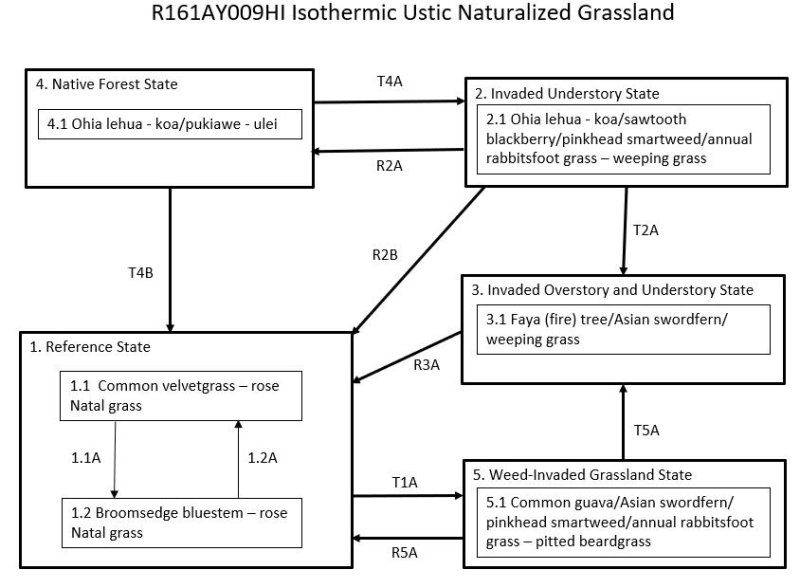
Ecosystem states
States 1 and 5 (additional transitions)
| T1A | - | State 1 Reference transitions to State 5 Weed Invaded Grassland by long-term continuous grazing and lack of weed control measures. Remnant desirable forages have been grazed out and replaced entirely by weedy grasses, forbs, shrubs, and small trees. |
|---|---|---|
| R2B | - | State 2 Invaded Understory can be restored to State 1 Reference by clearing the forest understory with heavy machinery, applying aggressive weed control measures, and replanting desirable forage species. |
| T2A | - | State 2 Invaded Understory transitions to State 3 Invaded Over and Understory through the process of fast-growing weeds inhibiting reproduction of native plants and gradually replacing them. This process is accelerated by feral ungulates directly damaging native plants and promoting the spread of weeds by disturbing the soil and spreading weed seeds. |
| R2A | - | State 2 Invaded Understory may be restored to a facsimile of State 4 Native Forest. Construction of a suitable fence and removal of all ungulates are necessary. Intensive weed control must then be initiated and maintained in the long term. In some cases, large amounts of dead weed biomass must be dealt with by removal or decomposition. Reintroduction of missing native species will be necessary. |
| R3A | - | State 3 Invaded Over and Understory can be converted to State 1 Reference by clearing vegetation using heavy machinery, appropriately dealing with slash piles, applying aggressive weed control measures, and planting desirable forage species. |
| T4B | - | State 4 Native Forest can transition to State 1 Reference by clearing the forest with heavy machinery or fire and planting desirable pasture species. Native forest may be cleared gradually by allowing cattle access to the forest. Cattle eventually eat or destroy understory ferns, forbs, shrubs, and saplings, opening the forest so that introduced grasses will thrive. |
| R5A | - | State 5 Weed Invaded Grassland can be restored to State 1 Reference by brush management, re-establishment of desirable forage species, persistent weed control, and prescribed grazing. |
| T5A | - | State 5 Weed Invaded Grassland transitions to State 3 Invaded Over and Understory due to the presence of fast-growing, introduced tree species; fire may delay this process. |
State 1 submodel, plant communities
| P1.1A | - | Phase 1.1 changes to phase 1.2 by long-term continuous grazing. Remnant high-quality forages have been reduced in abundance and largely replaced by lower-value species. Weedy forbs and shrubs are increasing. |
|---|---|---|
| P1.2A | - | A grazing plan is needed that provides for intensive but temporary grazing of pastures to ensure that cattle consume some low-value forage species along with preferred forages and to allow preferred forages time to recover from defoliation. Kikuyugrass is highly competitive and able to recover with proper management. The grazing plan may require splitting the herd, creating additional water sources, and creating multiple pastures by cross-fencing. Weed control may be necessary to eliminate some species such as inedible shrubs. |