Natural Resources
Conservation Service
Ecological site QX191X01X504
Limestone Plateau Cloud Forest
Last updated: 6/04/2025
Accessed: 04/11/2026
General information
Provisional. A provisional ecological site description has undergone quality control and quality assurance review. It contains a working state and transition model and enough information to identify the ecological site.
MLRA notes
Major Land Resource Area (MLRA): 191X–High Limestone Plateaus of the Mariana Islands
This MLRA consists of the northern half of Guam and the islands of Saipan), Tinian, Rota, and Aguijan. Topography consists mostly of limestone plateaus. The highest elevations are 1,700 feet (520 meters) on Rota, 1,485 feet (450 meters) on Saipan, 655 feet (200 meters) on Tinian, and 860 feet (260 meters) in the northern part of Guam. The limestone plateaus were uplifted by tectonic activity. Deeply weathered volcanic rock is exposed on some ridges and slopes. Average annual rainfall is 100 inches (2,540 millimeters) on northern Guam and 80 inches (2,030 millimeters) on Saipan, Tinian, Aguijan, and Rota. The rainy season occurs from July through November; the dry season occurs from December through June. Trade winds blow from the northeast. Average annual temperature is 79 degrees F (26 degrees C). Typhoons are frequent. Soils are Alfisols, Andisols, Entisols, Mollisols, or Oxisols. The dominant soil moisture regime is ustic. The soil temperature regime is isohyperthermic. Native vegetation consists of mixed tropical hardwoods; introduced white leadtree or tangantangan trees are abundant. Introduced deer, pigs, goats, and water buffalo are common (USDA-NRCS, 2006). The main human disturbance is clearing land for cultivation. Feral pigs, feral cattle, brown tree snakes, stray dogs (Boonie dogs), and introduced deer are destructive to the native forest (Amand, 2000; CNMI SWARS Council, 2010; Donnegan et al., 2011; Liske-Clark, 2015; Willsey et al., 2019).
Classification relationships
This ecological site occurs within Major Land Resource Area (MLRA) 191 – High Limestone Plateaus of the Mariana Islands.
Ecological site concept
This ecological site occurs on the island of Rota in the Marianas Islands. It occurs on nearly level to modserately sloping (0 to 15 percent slopes) limestone plateaus at elevations ranging from 1,310 to 1570 feet (400 to 480 meters) (USDA-SCS, 1989).
Soils are shallow, well drained Entisols (lithic ustorthents) in “moist” phases of Luta series that formed in sediment over porous coralline limestone. Soil temperature regimes are isohyperthermic; soil moisture regimes are ustic. Average annual precipitation is 116 inches (2,945 millimeters) and ranges from 113 to 120 inches (2,870 to 3,050 millimeters) (PRISM, 2006). The area is often shrouded in clouds and fog. Water runoff is very low or low; permeability is moderately rapid. Effective rooting depth is 10 to 16 inches (25 to 40 cm). Available water-holding capacity is very low (1 inch) (USDA-SCS, 1989). Most of the area is vegetated by native forest (Amidon et al., 2017; Falanruw et al., 1989; Fosberg, 1960; Liu and Fischer, 2008; Stone, 1970; Wagner and Grether, 1948; Willsey et al., 2019).
Associated sites
| QX191X01X505 |
Very Low Available Water Capacity Soils on Limestone Plateaus and Escarpments Soils of QX191X01X505 (The Very Low Available Water Capacity Soils on Limestone Plateaus and Escarpments Ecological Site) formed in porous coralline limestone. Effective rooting depth is 2 to 16 inches; available water holding capacity is very low (1). Most of the area is vegetated by native forest. Soils of Q191X01X504 (The Limestone Plateau Cloud Forest Ecological Site) formed in limestone. Effective rooting depth is 10 to 16 inches and available water holding capacity is also very low (1). Most of the area is vegetated by native forest. Moisture is added to the soil by fog drip, which maintains moist soils. |
|---|---|
| QX191X01X002 |
Moderately Deep Alfic Soils on Volcanic Uplands Soils of QX191X01X002 (The Moderately Deep Alfic Soils on Volcanic Uplands Ecological Site) formed in residuum derived from andesitic marine tuff and tuffaceous breccia. They are highly weathered Alfisols that have fairly high base saturation, effective rooting depths of approximately 32 inches, surface pH of 6.2 to 6.5, and low available water holding capacity (4 inches). Most of the area is vegetated by grasses, forbs, and mixed forest of introduced and native species. Pacific Island silvergrass or swordgrass (Miscanthus floridulus) is present in some areas. white lead tree or tangantangan (Leucaena leucocephala) is not abundant. Soils of Q191X01X504 (The Limestone Plateau Cloud Forest Ecological Site) formed in fine materials over porous coralline limestone. Effective rooting depth is about 12 inches, surface pH of 7.0 to 7.2; available water holding capacity is very low (1 inch). Most of the area is vegetated by native forest. This ecological site is limited to an area that is often shrouded in clouds and fog. Moisture is added to the soil by fog drip, which maintains the soils in moist condition most of the time. |
| QX191X01X503 |
Very Shallow to Moderately Deep Soils on Limestone Plateaus Soils of QX191X01X503 (The Very Shallow to Moderately Deep Soils on Limestone Plateaus Ecological Site) formed in fine materials over porous coralline or argillaceous limestone. Effective rooting depth is 2 to 20 inches and available water holding capacity is very low to low (2 to 3 inches). Areas not farmed are vegetated by mostly introduced grass, forb, and tree species, with some areas of native upland forest. Tangantangan (Leucaena leucocephala) is abundant in places. Soils of Q191X01X504 (The Limestone Plateau Cloud Forest Ecological Site) formed in fine materials over porous coralline limestone. Effective rooting depth is about 12 inches, surface pH of 7.0 to 7.2; available water holding capacity is very low (1 inch). Most of the area is vegetated by native forest. This ecological site is limited to an area that is often shrouded in clouds and fog. Moisture is added to the soil by fog drip, which maintains the soils in moist condition most of the time. |
Table 1. Dominant plant species
| Tree |
(1) Hernandia labyrinthica |
|---|---|
| Shrub |
(1) Freycinetia reineckei |
| Herbaceous |
Not specified |
Legacy ID
F191XY504MP
Click on box and path labels to scroll to the respective text.
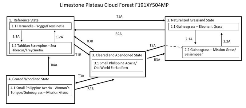
Ecosystem states
| T1A | - | The Reference State (1) may transition to the Naturalized Grassland State (2) by mechanical clearing of the land followed by invasion by or planting of introduced forage species. |
|---|---|---|
| T1B | - | The Reference State (1) may transition to the Cleared and Abandoned State (3) by clearing the forest, temporary cultivation of crops, abandonment, and invasion by mostly introduced species. |
| R2A | - | The Naturalized Grassland State (2) can be restored to a facsimile of the Reference State (1) by suppressing the forage species and replanting native trees. |
| T2A | - | The Naturalized Grassland State (2) will transition to the Cleared and Abandoned State (3) from community phase 2.1 if the forage species are reduced in cover and vitality by heavy grazing before abandonment, allowing invasion of the site by weedy shrub, forb, and vine species. |
| R3B | - | The Cleared and Abandoned State (3) can be restored to a facsimile of the Reference State (1) by brush and weed control followed by replanting of native trees. |
| R3A | - | The Cleared and Abandoned State (3) may be restored to the Naturalized Grassland State (2) by brush control, weed control, reseeding of desired forage species, and cutting back white leadtree to a shorter stature. |
| T3A | - | The Cleared and Abandoned State (3) will transition to the Grazed Woodland State (4) by continued growth and spread of small Philippine acacia, possible invasion by other tree species, and closure of the overstory to shade out most shrubs, forbs, and grasses. |
| R4A | - | The Grazed Woodland State (4) may be restored to a facsimile of the Reference State (1) by brush and weed control followed by replanting of native trees. |
| R4B | - | The Grazed Woodland State (4) may be restored to the Cleared and Abandoned State (3) by clearing and abandoning the site, allowing lower-growing species that require sunlight to invade. |
State 1 submodel, plant communities
| 1.1A | - | Community phase 1.1 may shift to phase 1.2 by damage from powerful storms. |
|---|---|---|
| 1.2A | - | Community phase 1.2 reverts to phase 1.1 by regrowth of the original dominant species if given enough time between strong storm events. Browsing and grazing by introduced ungulates may inhibit this process by destruction of tree seedlings. |
State 2 submodel, plant communities
| 2.1A | - | Community phase 2.1 will shift to phase 2.2 by overgrazing, which allows invasion by unpalatable grass and forb species. |
|---|---|---|
| 2.2A | - | Community phase 2.2 will revert to phase 2.1 with properly managed grazing, which allows desirable species to gradually regain dominance, and possible spot weed control. |