Natural Resources
Conservation Service
Ecological site QX197X01X502
Sandy Littoral Forest
Last updated: 6/12/2025
Accessed: 03/16/2026
General information
Provisional. A provisional ecological site description has undergone quality control and quality assurance review. It contains a working state and transition model and enough information to identify the ecological site.
MLRA notes
Major Land Resource Area (MLRA): 197X–Volcanic Islands of American Samoa
This MLRA consists of the islands of Tutuila, Aunuu, Ofu, Olosega, and Tau. The islands have extremely steep, highly dissected mountains, small valleys, and a narrow coastal plain. More than half of the area has slopes of more than 70 percent. The highest elevations are 3,056 feet (931 meters) on Tau and 2,142 feet (653 meters) on Tutuila. The islands consist of Pleistocene-age, basic igneous rocks, mainly basalt with some andesite and trachyte (USDA-NRCS, 2006).
The climate is moist, warm, and humid. Average annual rainfall ranges from 125 inches (3,175 millimeters) to more than 250 inches (6,350 millimeters). Rainfall varies over short distances due to topography. The driest months are June through September; the wettest months are December through March. Average annual temperature is 81 degrees F (27 degrees C). Relative humidity is 73 to 90 percent throughout the year. Prevailing winds are easterly trade winds. Cyclones occasionally strike the area (USDA-NRCS, 2006).
Soils are Mollisols, Andisols, Entisols, Oxisols, and Histosols. Soil moisture regimes are udic or perudic; the soil temperature regime is isohyperthermic. Natural vegetation is mostly tropical hardwood forest (USDA-NRCS, 2006).
Classification relationships
This ecological site occurs within Major Land Resource Area (MLRA) 197 – Volcanic Islands of American Samoa.
Ecological site concept
This ecological site occurs on the islands of Tutuila, Aunuu, Ofu, Olosega, and Tau in American Samoa. It occurs on nearly level to gently sloping (0 to 15 percent) coastal plains at elevations ranging from 0 to 15 feet (0 to 5 meters) elevation. It is most easily accessible on the southeastern coast of Tutuila.
Soils are Psamments (sandy Entisols) that formed in sand and rubble derived from coral and seashells deposited along the seashore of coastal plains. Soil temperature regimes are isohyperthermic; soil moisture regimes are udic. Average annual rainfall ranges from 120 to 200 inches (300 to 500 centimeters). Water runoff is very slow to slow, but drainage is somewhat excessive to excessive. Effective rooting depth is greater than 60 inches (150 centimeters), but available water-holding capacity is low (about 3.5 inches). Windborne salt spray and occasional, very brief to brief flooding by seawater help determine the vegetation type.
Much of this ecological site is forested, but thin bands of small herbaceous plants, shrubs, and scrub forest typically occupy the zone closest to the ocean. The forest canopy grows up to about 50 feet (15 meters) tall. The forest floor is usually open due to dense shade. Epiphytes and vines are sparse.
Associated sites
| QX197X01X501 |
Mangrove Swamp Mangrove Swamp occurs along partially-protected coastlines where it may adjoin sandy bars and oceanfront areas that support Sandy Littoral Forest. Soils are very poorly drained and flooded twice daily by tides, in contrast with somewhat excessively to excessively |
|---|---|
| QX197X01X505 |
Skeletal Pachic or Fulvic Forest Skeletal Pachic or Fulvic Forest adjoins Sandy Littoral Forest where uplands, talus slopes, and mountain slopes descend to sandy coastlines. It occurs on mountain slopes up to 900 feet in elevation, undergoes no flooding, and has well drained soils, in contrast with Sandy Littoral Forest, which ascends to 15 feet elevation, undergoes occasional, very brief to brief flooding by seawater, and has somewhat excessively to excessively drained soils. |
| QX197X01X506 |
Tuff or Rock Subsurface Forest Tuff or Rock Subsurface Forest can adjoin Sandy Littoral Forest where uplands and mountain slopes come down to coastlines where Sandy Littoral Forest occurs. It occurs on mountain slopes up to 1500 feet in elevation, undergoes no flooding, and has well drained soils, in contrast with Sandy Littoral Forest, which ascends to 15 feet elevation, undergoes occasional, very brief to brief flooding by seawater, and has somewhat excessively to excessively drained soils. |
| QX197X01X509 |
Very Steep Forest Very Steep Forest adjoins Sandy Littoral Forest where very steep mountain slopes descend to sandy coastlines. It occurs on slopes up to 2100 feet in elevation, undergoes no flooding, and has well drained soils, in contrast with Sandy Littoral Forest, which ascends to 15 feet elevation, undergoes occasional, very brief to brief flooding by seawater, and has somewhat excessively to excessively drained soils. |
Similar sites
| QX197X01X507 |
Dry Coastal Forest Dry Coastal Forest is similar to Sandy Littoral Forest in that both ecological sites are exposed to more-or-less salt-laden winds near the coast. They differ in that Dry Coastal Forest occurs to elevations of 400 feet, has well drained soils, and does not undergo flooding, whereas Sandy Littoral Forest occurs to elevations of 15 feet, has somewhat excessively to excessively drained soils, and undergoes occasional, very brief to brief flooding by seawater. |
|---|
Table 1. Dominant plant species
| Tree |
(1) Barringtonia asiatica |
|---|---|
| Shrub |
Not specified |
| Herbaceous |
(1) Asplenium nidus |
Legacy ID
F197XY502AS
Click on box and path labels to scroll to the respective text.
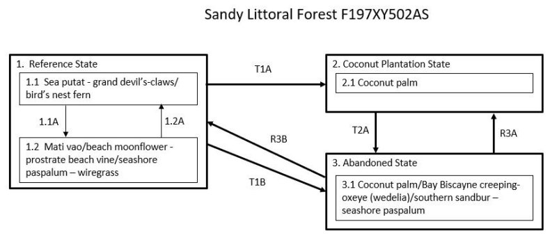
Ecosystem states
| T1A | - | State 1 Reference transitions to State 2 Coconut Plantation by removal of native vegetation and planting coconut palms (Cocos nucifera). |
|---|---|---|
| T1B | - | State 1 Reference transitions to State 3 Abandoned if cleared and abandoned. This allows heliophytes, both native and introduced, to temporarily cover the understory. |
| T2A | - | State 2 Coconut Plantation transitions to State 3 Abandoned with abandonment of coconut plantations, which are quickly invaded by low-statured, native and/or introduced heliophytes. |
| R3B | - | State 3 Abandoned may be restored to State 1 Reference. The intensity of active restoration measures will be determined by the presence or lack of nearby native forest or, at least, some native trees as well as the density and species mix of grasses, vines, shrubs, and trees present on the site, especially if many competitive introduced species are present. |
| R3A | - | State 3 Abandoned may be restored to State 2 Coconut Plantation by land clearing, weed control, and replanting coconut palms. |
State 1 submodel, plant communities
| P1.1A | - | Storms that disturb or kill trees causes a phase change from 1.1, which has all native tree species, to 1.2, which temporarily has an open stand of native trees with an understory of mostly native vines and grasses. |
|---|---|---|
| P1.2A | - | This community phase will revert to phase 1.1 with gradual regrowth of native species when given adequate time to recover after disturbance. However, it is likely that some introduced species will remain. |