Natural Resources
Conservation Service
Ecological site QX197X01X001
Coastal Marsh
Last updated: 6/12/2025
Accessed: 04/11/2026
General information
Provisional. A provisional ecological site description has undergone quality control and quality assurance review. It contains a working state and transition model and enough information to identify the ecological site.
MLRA notes
Major Land Resource Area (MLRA): 197X–Volcanic Islands of American Samoa
This MLRA consists of the islands of Tutuila, Aunuu, Ofu, Olosega, and Tau. The islands have extremely steep, highly dissected mountains, small valleys, and a narrow coastal plain. More than half of the area has slopes of more than 70 percent. The highest elevations are 3,056 feet (931 meters) on Tau and 2,142 feet (653 meters) on Tutuila. The islands consist of Pleistocene-age, basic igneous rocks, mainly basalt with some andesite and trachyte (USDA-NRCS, 2006).
The climate is moist, warm, and humid. Average annual rainfall ranges from 125 inches (3,175 millimeters) to more than 250 inches (6,350 millimeters). Rainfall varies over short distances due to topography. The driest months are June through September; the wettest months are December through March. Average annual temperature is 81 degrees F (27 degrees C). Relative humidity is 73 to 90 percent throughout the year. Prevailing winds are easterly trade winds. Cyclones occasionally strike the area (USDA-NRCS, 2006).
Soils are Mollisols, Andisols, Entisols, Oxisols, and Histosols. Soil moisture regimes are udic or perudic; the soil temperature regime is isohyperthermic. Natural vegetation is mostly tropical hardwood forest (USDA-NRCS, 2006).
Classification relationships
This ecological site occurs within Major Land Resource Area (MLRA) 197 – Volcanic Islands of American Samoa.
Ecological site concept
This ecological site occurs on the islands of Tutuila, Aunuu, Ofu, Olosega, and Tau in American Samoa. It occurs on nearly level (0 to 2 percent) in depressions or basins on coastal plains at elevations ranging from 0 to 20 feet (0 to 6 meters) elevation. It is most easily accessible on the coastal plain or in the crater on Aunuu (USDA-SCS, 1984).
Soils are in the Histosols (Terric Haplosaprists), Mollisols (Cumulic Haplaquolls), and Entisols (Mollic Psammaquents) orders. They consist of mucky sandy loam, mucky clay loam, or peat that formed from organic matter over coral sand and alluvium. Soil temperature regimes are isohyperthermic; soil moisture regimes are aquic. Average annual rainfall ranges from 150 to 200 inches (3750 to 5000 millimeters). Water runoff is slow. Soils are commonly ponded, and flooding is occasional to frequent and of brief duration . Effective rooting depth is 40 to 60 inches (100 to 150 centimeters). Groundwater and surface water are fresh or slightly brackish (USDA-SCS, 1984).
This ecological site is herbaceous marsh dominated by sedges and ferns. It is separated from seawater by low ridges or littoral or alluvial deposits and fed with fresh water by streams (USDA-SCS, 1984; Whistler, 2002).
Associated sites
| QX197X01X505 |
Skeletal Pachic or Fulvic Forest Skeletal Pachic or Fulvic Forest adjoins Coastal Marsh where uplands, talus slopes, and mountain slopes come down to depressions on coastal plains. It occurs on slopes up to 900 feet in elevation and has well drained soils, in contrast with Coastal Marsh, which ascends to 20 feet elevation and has very poorly drained soils. |
|---|---|
| QX197X01X506 |
Tuff or Rock Subsurface Forest Tuff or Rock Subsurface Forest adjoins Coastal Marsh where uplands and mountain slopes descend to depressions on coastal plains. It occurs on slopes up to 1500 feet in elevation and has well drained soils, in contrast with Coastal Marsh, which ascends to 20 feet elevation and has very poorly drained soils. |
Similar sites
| QX197X01X501 |
Mangrove Swamp Like Coastal Marsh, Mangrove Swamp occurs on very poorly drained soils to elevations no greater than 20 feet. However, Mangrove Swamp is open to seawater, making its waters saline rather than fresh, undergoes twice-daily tidal flooding rather than occasional to frequent flooding, and is accessible to mangrove seeds and seedlings. |
|---|
Table 1. Dominant plant species
| Tree |
Not specified |
|---|---|
| Shrub |
Not specified |
| Herbaceous |
(1) Eleocharis dulcis |
Legacy ID
R197XY001AS
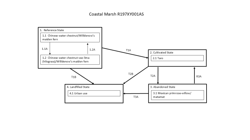
Click on box and path labels to scroll to the respective text.
| T1A | - | State 1 Reference transitions to State 2 Cultivated removal of native vegetation and planting taro (Alocasia macrorrhizos). |
|---|---|---|
| T1B | - | State 1 Reference transitions to State 4 Landfilled by intentional filling of a marsh to create construction sites. |
| T2A | - | State 2 Cultivated transitions to State 3 Abandoned with abandonment of taro fields, which are quickly invaded by mostly introduced species. |
| T2B | - | State 2 Cultivated transitions to State 4 Landfilled by intentional filling of cropland to create construction sites. |
| R3A | - | State 3 Abandoned can be restored to State 2 Cultivated by weed removal and resumption of taro cultivation. |
| T3A | - | State 3 Abandoned transitions to State 4 Landfilled by intentional filling of cropland to create construction sites. |
State 1 submodel, plant communities
| P1.1A | - | This phase change occurs due to damage to native vegetation stands by storms. |
|---|---|---|
| P1.2A | - | This community phase may revert to phase 1.1 with gradual regrowth of native species when given adequate time to recover after disturbance. However, it is likely that some introduced species will remain. |