Natural Resources
Conservation Service
Ecological site QX197X01X504
Alluvial Valley Forest
Last updated: 6/12/2025
Accessed: 04/11/2026
General information
Provisional. A provisional ecological site description has undergone quality control and quality assurance review. It contains a working state and transition model and enough information to identify the ecological site.
MLRA notes
Major Land Resource Area (MLRA): 197X–Volcanic Islands of American Samoa
This MLRA consists of the islands of Tutuila, Aunuu, Ofu, Olosega, and Tau. The islands have extremely steep, highly dissected mountains, small valleys, and a narrow coastal plain. More than half of the area has slopes of more than 70 percent. The highest elevations are 3,056 feet (931 meters) on Tau and 2,142 feet (653 meters) on Tutuila. The islands consist of Pleistocene-age, basic igneous rocks, mainly basalt with some andesite and trachyte.
The climate is moist, warm, and humid. Average annual rainfall ranges from 125 inches (3,175 millimeters) to more than 250 inches (6,350 millimeters). Rainfall varies over short distances due to topography. The driest months are June through September; the wettest months are December through March. Average annual temperature is 81 degrees F (27 degrees C). Relative humidity is 73 to 90 percent throughout the year. Prevailing winds are easterly trade winds. Cyclones occasionally strike the area.
Soils are Mollisols, Andisols, Entisols, Oxisols, and Histosols. Soil moisture regimes are udic or perudic; the soil temperature regime is isohyperthermic. Natural vegetation is mostly tropical hardwood forest.
Classification relationships
This ecological site occurs within Major Land Resource Area (MLRA) 197 – Volcanic Islands of American Samoa.
Ecological site concept
This ecological site occurs on the island of Tutuila in American Samoa. It occurs on nearly level to gently sloping (0 to 6 percent) valley floors and coastal plains at elevations ranging from 0 to 250 feet (0 to 77 meters) elevation. It is accessible on the southern side of Tutuila.
Soils are Cumulic Hapludolls (Mollisols soil order). “Cumulic” means they have a thick mollic epipedon that developed by accumulation of surface material as the soils developed. They formed in alluvium deposited over basic igneous rock. Soil temperature regimes are isohyperthermic; soil moisture regimes are udic. Average annual rainfall ranges from 150 to 250 inches (375 to 625 centimeters). Water runoff is slow. Effective rooting depths are more than 60 inches (150 centimeters). The soils in this ecological site are somewhat poorly drained and undergo occasional, brief flooding.
This forest type has a stratified canopy. The upper canopy grows up to 100 feet (30 meters) tall. Ground cover is moderate to dense; epiphytes and lianas are common.
Associated sites
| QX197X01X501 |
Mangrove Swamp Mangrove Swamp adjoins Alluvial Valley Forest where valley floors and coastal plains descend to partially-protected coastal salt water. Mangrove Swamp differs from Alluvial Valley Forest in being very poorly drained rather than somewhat poorly drained, having salt water rather than fresh water, and by undergoing twice-daily tidal flooding rather than occasional, brief flooding. |
|---|---|
| QX197X01X503 |
Lavaflow Forest Lavaflow Forest adjoins Alluvial Valley Forest in the few locations where alluvial valleys descend to young aa lava flows near the coast. Alluvial Valley Forest has somewhat poorly drained, mineral soils; Lavaflow Forest has well drained, organic soils in the interstices between aa rocks. |
| QX197X01X507 |
Dry Coastal Forest Dry Coastal Forest adjoins Alluvial Valley Forest where sloping uplands, side slopes, and mountain slopes descend to alluvium-filled valleys near the coast. Dry Coastal Forest has well drained Andisols with limited rooting depth formed from volcanic ash deposited over hard tuff, or, in one case, in the interstices between aa rocks; Alluvial Valley Forest has somewhat poorly drained Cumulic Mollisols with very deep rooting depth and formed in alluvium. |
| QX197X01X505 |
Skeletal Pachic or Fulvic Forest Skeletal Pachic or Fulvic Forest adjoins Alluvial Valley Forest where uplands, talus slopes, and mountain slopes descend to alluvium-filled valleys near the coast. It occurs on mountain slopes up to 900 feet in elevation, undergoes no flooding, and has well drained soils, in contrast with Alluvial Valley Forest, which ascends to 250 feet elevation, undergoes occasional brief flooding, and has somewhat poorly drained soils. |
| QX197X01X509 |
Very Steep Forest Very Steep Forest adjoins Alluvial Valley Forest where very steep mountain slopes descend to alluvium-filled valleys near the coast. It occurs on slopes up to 2100 feet in elevation, undergoes no flooding, and has well drained soils, in contrast with Alluvial Valley Forest, which ascends to 250 feet elevation, undergoes occasional brief flooding, and has somewhat poorly drained soils. |
Table 1. Dominant plant species
| Tree |
(1) Dysoxylum |
|---|---|
| Shrub |
Not specified |
| Herbaceous |
(1) Lomagramma cordipinna |
Legacy ID
F197XY504AS
Click on box and path labels to scroll to the respective text.
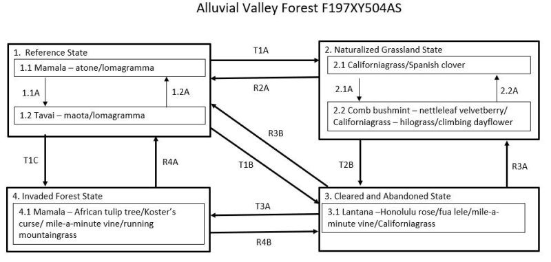
Ecosystem states
| T1A | - | State 1 Reference transitions to State 2 Naturalized by removal of native vegetation and planting, or allowing colonization by, introduced grass species. |
|---|---|---|
| T1B | - | State 1 Reference transitions to State 3 Cleared and Abandoned if previously cleared of forest and then abandoned. This allows heliophytes, both native and introduced, to temporarily cover the ground. |
| T1C | - | State 1 Reference transitions to State 4 Invaded Forest by wind damage to the forest when there is a nearby source of seeds of invasive species or, more gradually, by damage to the forest understory by ungulates, especially feral pigs, when there is a source of seeds of invasive species. |
| R2A | - | State 2 Naturalized Grassland could theoretically be restored to State 1 Reference by suppression of grassland vegetation and replanting with native species. Natural reseeding by native forest species can be expected if there is a nearby stand of suitable species |
| T2B | - | State 2 Naturalized Grassland transitions to State 3 Cleared and Abandoned occurs with abandonment of grasslands, which are invaded by low-statured, native and/or introduced heliophytes. |
| T3A | - | State 3 Cleared and Abandoned transitions to State 4 Invaded Forest by growth of an overstory of trees with an understory of shade-tolerant shrubs, vines, ferns, forbs, and grasses. The species mix is variable but may be mostly introduced species or a combination of native and introduced species. |
| R4A | - | State 4 Invaded Forest can be restored to State 1 Reference. The difficulty, cost, and likelihood of success will depend on the species composition and amount and competitiveness of introduced species present on a given site. |
| R4B | - | State 4 Invaded Forest can be restored to State 3 Cleared and Abandoned. After this “restoration,” State 3 is likely to rapidly transition back to State 4 due to presence of an abundant tree seed bank in the soil. |
State 1 submodel, plant communities
| P1.1A | - | Storms or fires that damage or kill trees causes a phase change from 1.1 to 1.2 typified by a partial, temporary change in dominant tree species and a temporary increase in ground level vegetation. |
|---|---|---|
| P1.2A | - | This community phase will revert to phase 1.1 with gradual regrowth of native species when given adequate time to recover after disturbance. |
State 2 submodel, plant communities
| P2.1A | - | Community phase 2.1 will change to 2.2 by invasion of the site by shrubs and forbs. This process is facilitated by excessive grazing, which reduces the competitive advantage of Californiagrass. |
|---|---|---|
| P2.2A | - | Community phase 2.2 can shift back to phase 2.1 by reducing grazing pressure on Californiagrass and, when necessary, performing spot weed control on shrubs and vines |