Natural Resources
Conservation Service
Ecological site QX197X01X508
Cinder Subsurface Forest
Last updated: 6/12/2025
Accessed: 04/10/2026
General information
Provisional. A provisional ecological site description has undergone quality control and quality assurance review. It contains a working state and transition model and enough information to identify the ecological site.
MLRA notes
Major Land Resource Area (MLRA): 197X–Volcanic Islands of American Samoa
This MLRA consists of the islands of Tutuila, Aunuu, Ofu, Olosega, and Tau. The islands have extremely steep, highly dissected mountains, small valleys, and a narrow coastal plain. More than half of the area has slopes of more than 70 percent. The highest elevations are 3,056 feet (931 meters) on Tau and 2,142 feet (653 meters) on Tutuila. The islands consist of Pleistocene-age, basic igneous rocks, mainly basalt with some andesite and trachyte.
The climate is moist, warm, and humid. Average annual rainfall ranges from 125 inches (3,175 millimeters) to more than 250 inches (6,350 millimeters). Rainfall varies over short distances due to topography. The driest months are June through September; the wettest months are December through March. Average annual temperature is 81 degrees F (27 degrees C). Relative humidity is 73 to 90 percent throughout the year. Prevailing winds are easterly trade winds. Cyclones occasionally strike the area.
Soils are Mollisols, Andisols, Entisols, Oxisols, and Histosols. Soil moisture regimes are udic or perudic; the soil temperature regime is isohyperthermic. Natural vegetation is mostly tropical hardwood forest.
Classification relationships
This ecological site occurs within Major Land Resource Area (MLRA) 197 – Volcanic Islands of American Samoa.
Ecological site concept
This ecological site occurs on the islands of Tutuila and Tau in American Samoa. It occurs on gently sloping to steep (6 to 40 percent) mountain side slopes at elevations ranging from 900 to 3000 feet (0 to 923 meters) elevation. Access is difficult in most areas.
Soils are in the Andisols order. They formed in volcanic ash overlying cinders. Soil temperature regimes are isohyperthermic; soil moisture regimes are perudic. Average annual rainfall ranges from 175 to 300 inches (438 to 750 centimeters), and cloud cover and fog occur frequently at the higher elevations of the ecological site. There is no dry season and soils are usually very moist. Water runoff is slow to medium, although it is rapid on a few slopes. Air temperatures for the most part is slightly cooler than those in other areas of American Samoa. Effective rooting depths are greater than 60 inches (150 centimeters). Rock fragment contents range from none to 10 percent gravel.
This is the most diverse forest type in American Samoa. Ground cover is dense, and epiphytes and climbing plants are abundant.
At the very highest elevations of this ecological site, two distinct vegetation types have been described in the literature. They are usually name “Summit Scrub” and “Montane Scrub.” Due to extreme accessibility problems, there are no distinct soils mapped in these areas that would account for these two vegetation types in the ecological site system. Further information can be found in Whistler (2002).
Associated sites
| QX197X01X505 |
Skeletal Pachic or Fulvic Forest Skeletal Pachic or Fulvic Forest adjoins Cinder Subsurface Forest where high-elevation (>900 feet) uplands and mountainsides descend to lower elevation (up to 900 feet) uplands, mountainsides, and talus slopes. Its soils are Mollisols and Andisols with high organic carbon and rock contents that overlie lava rock. Cinder Subsurface Forest consists of Andisols with little or no rock content that overlie weathered cinders. |
|---|---|
| QX197X01X509 |
Very Steep Forest Very Steep Forest adjoins Cinder Subsurface Forest where very steep slopes border on less-steep slopes on mountainsides at high elevations. Very Steep Forest has slopes of 70 to 130 percent and occurs at elevations of 0 to about 2100 feet. Cinder Subsurface Forest has slopes of 6 to 40 percent and occurs at elevations of 900 to 3000 feet. |
Table 1. Dominant plant species
| Tree |
(1) Dysoxylum huntii |
|---|---|
| Shrub |
(1) Cyrtandra |
| Herbaceous |
(1) Hymenophyllum |
Legacy ID
F197XY508AS
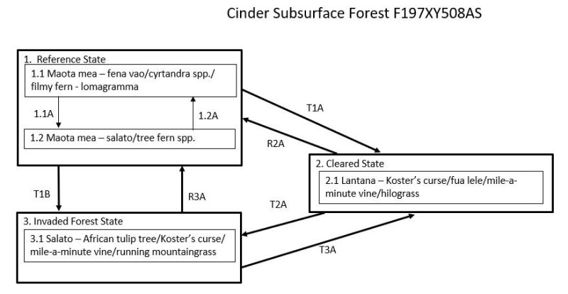
Click on box and path labels to scroll to the respective text.
Ecosystem states
| T1A | - | State 1 Reference transitions to State 2 Cleared by large landslides, very severe storms, or removal of native vegetation and allowing colonization by weedy, introduced plant species when a nearby seed source for these invaders is present. |
|---|---|---|
| T1B | - | State 1 Reference transitions to State 3 Invaded Forest by landslide or wind damage to the forest when there is a nearby source of seeds of invasive species or, more gradually, by damage to the forest understory by ungulates, especially feral pigs, when there is a source of seeds of invasive species. |
| R2A | - | State 2 Cleared may be restored to State 1 Reference. The intensity of active restoration measures will be determined by the presence or lack of nearby native forest or, at least, some native trees as well as the density and species mix of grasses, vines, shrubs, and invasive trees present on the site, especially if many competitive introduced species are present. |
| T2A | - | State 2 Cleared transitions to State 3 Invaded Forest by growth of an overstory of trees with an understory of shade-tolerant shrubs, vines, ferns, forbs, and grasses. The species mix is variable but may be mostly introduced species or a combination of native and introduced species. |
| R3A | - | State 3 Invaded Forest can be restored to State 1 Reference. The difficulty, cost, and likelihood of success will depend on the species composition and amount and competitiveness of introduced species present on a given site. |
| T3A | - | State 3 Invaded Forest can transition back to State 2 Cleared due to damage by landslide, a severe storm, or clearing by humans. State 2 is likely to rapidly transition to State 3 due to presence of an abundant tree seed bank in the soil. |
State 1 submodel, plant communities
| P1.1A | - | Storms or landslides that damage or kill trees, or clearing of small plots by humans, when there is no significant source of invasive introduced plant species nearby causes a phase change from 1.1 to 1.2 typified by a partial, temporary change in dominant tree species and a temporary increase in ground level vegetation. |
|---|---|---|
| P1.2A | - | This community phase will revert to phase 1.1 with gradual regrowth of native species when given adequate time to recover after disturbance. |