Ecological dynamics
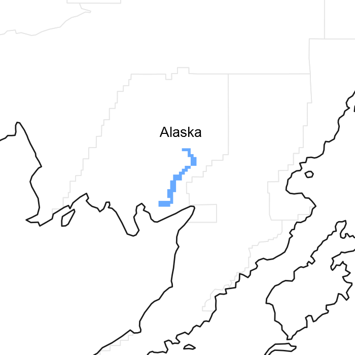
This boreal ecological site is on levees of lowland flood plains. Elevation typically ranges from sea level to 220 feet above sea level, and slopes are 0 to 5 percent. Slope aspect does not influence the plant community dynamics of this site.
This ecological site is correlated to D36-Boreal grass loamy levees. This soil has a cryic temperature regime and a udic moisture regime. The saturated hydraulic conductivity is moderately high to a depth of 40 inches. The upper mineral horizon is slightly acid to very strongly acid (pH 6.1 to 4.9), and it has an organic matter content of 8 to 12 percent. The soil typically is moderately well drained. The annual precipitation is 24 to 35 inches, and the annual frost-free period is 85 to 140 days. The parent material is sandy and silty alluvium over sandy alluvium.
The reference community phase is typified by a bluejoint grass (Calamagrostis canadensis) meadow that has some low and dwarf shrubs and abundant forbs. Medium and regenerating paper birch (Betula papyrifera) and white spruce (Picea glauca) trees may be present. As compared to other ecological sites on boreal flood plains, this ecological site is unique because it is on levees. The levees are subject to periods of flooding that vary in duration, frequency, and strength from those in low, mid, and high positions of flood plains. The resulting dissimilarities in reference states and community phases makes use of unique ecological sites necessary.
Flooding is the major disturbance regime for this ecological site; it is considered natural and typically is unmanaged. This site is subject to flooding because of the low elevation, minimal slope, and position on the lowland flood plains. Occasional, very brief periods of flooding occur in April through October. During the peak period of snowmelt (May and June), the water table typically is at a depth of 16 to 37 inches. The available background information suggests that the intensity of flooding and period since flooding occurred are critical in the distribution and abundance of vegetation in Alaskan riverine systems (Wohl, 2007). Flooding allows for plant succession by creating barren, moist areas for colonization, burying organic layers, adding nutrients to the soil, and depositing seed banks (Rood et al., 2007; Yarie et al., 1998). Flooding of the levees creates an early community phase. The reference community phase rarely may not be flooded for a long period, and trees such as paper birch (Betula papyrifera) and white spruce (Picea glauca) may colonize and create a woodland community. When flooding occurs again, the post-reference community phase is expected to transition to the early flooding community phase.
Slight browsing of forbs and willow by moose may occur in this ecological site, but it does not appear to affect the ecological processes significantly enough to alter the communities.
State 1
Reference State
The reference state supports three community phases, which are grouped by the structure and dominance of the vegetation (e.g., trees, graminoids, and forbs) and by their ecological function and stability. The presence of these community phases is temporally dictated by occasional periods of flooding. The reference community phase is characterized by grassland interspersed with forbs and some shrubs. A transition to a post-reference community phase may occur when the reference community phase is not flooded for a longer period than normal. No alternate states have been observed.
Community 1.1
Bluejoint grass/northern bedstraw-horsetails-fireweed/arctic raspberry grassland
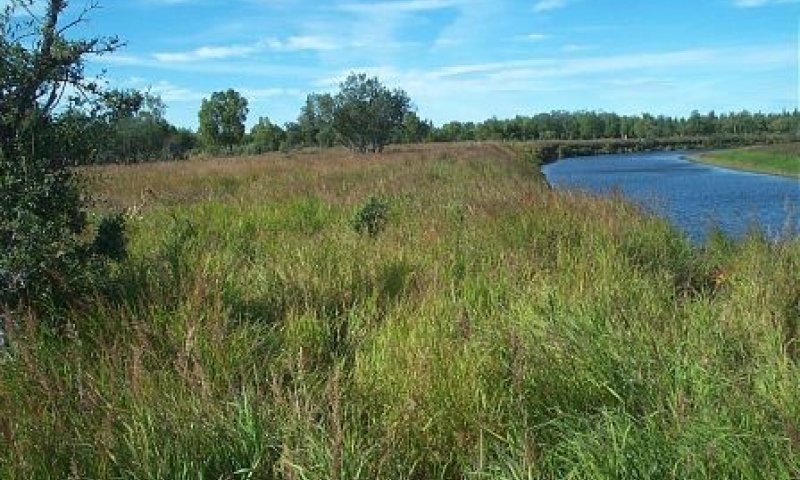
Figure 2. Typical area of community 1.1.
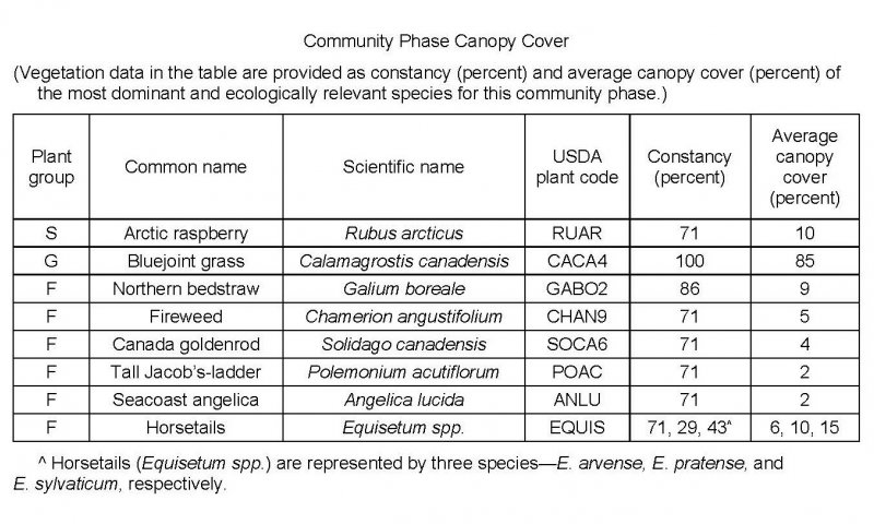
Figure 3. Constancy and canopy cover of plants in community 1.1.
The reference community phase is characterized by grassland that includes various forbs and scattered shrubs. Typically, this community consists mainly of bluejoint grass (Calamagrostis canadensis) and scattered northern bedstraw (Galium boreale), horsetails (Equisetum spp.), fireweed (Chamerion angustifolium), Canada goldenrod (Solidago canadensis), and arctic raspberry (Rubus arcticus). Other species may include tealeaf willow (Salix pulchra), purple marshlocks (Comarum palustre), common cowparsnip (Heracleum maximum), and Canadian burnet (Sanguisorba canadensis). Mosses typically are in the ground cover (about 20 percent total mean cover). Other ground cover commonly includes herbaceous litter (about 85 percent) and woody litter (about 2 percent). About 2 percent is bare soil.
Community 1.2
Tall Jacob’s-ladder–goldenrod–horsetails–fireweed/woodrush meadow
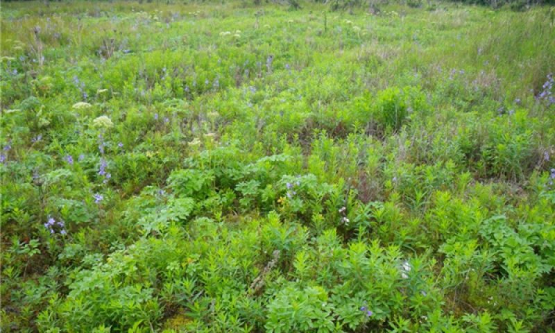
Figure 4. Typical area of community 1.2.
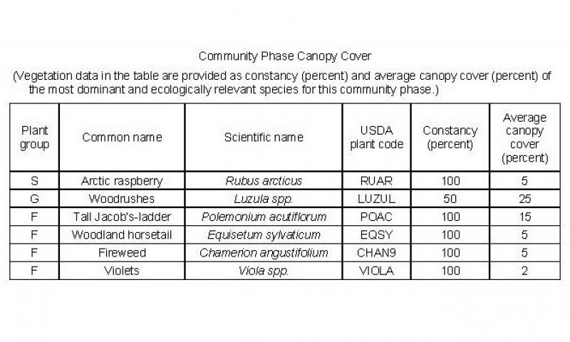
Figure 5. Constancy and canopy cover of plants in community 1.2.
The early flooding community phase is characterized by a forb meadow. Typically, this community consists tall Jacob’s-ladder (Polemonium acutiflorum), horsetails (Equisetum spp.), fireweed (Chamerion angustifolium), violets (Viola spp.), arctic raspberry (Rubus arcticus), and woodrushes (Luzula spp.). Other species include Bering chickweed (Cerastium beeringianum), goldenrod (Solidago spp.), tealeaf willow (Salix pulchra), and bedstraws (Galium spp.). Mosses commonly are in the ground cover (about 25 percent total mean cover). Other ground cover commonly includes herbaceous litter (about 80 percent cover) and woody litter (about 1 percent). About 1 percent is bare soil.
Note: The vegetation and soils for this community were sampled at two locations. Due to the limited data available, personal field observations were used to aid in describing this plant community.
Community 1.3
Paper birch/bluejoint grass/horsetails-fireweed-spreading woodfern woodland
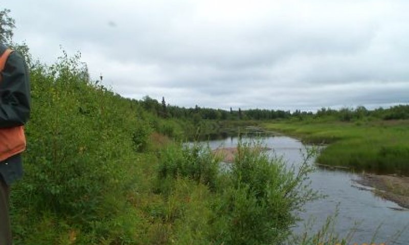
Figure 6. Typical area of community 1.3.
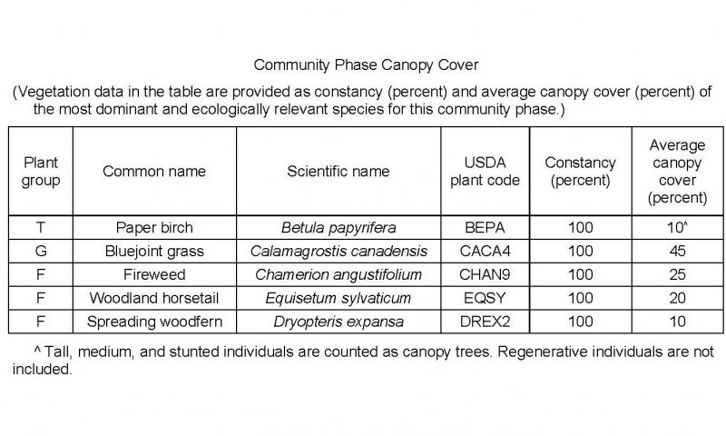
Figure 7. Constancy and canopy cover of plants in community 1.3.
The post-reference community phase is characterized by open woodland that has graminoids and forbs in the understory and in open areas. Typically, this community consists mainly of paper birch (Betula papyrifera). Bluejoint grass (Calamagrostis canadensis) and diverse forbs, including fireweed (Chamerion angustifolium), spreading woodfern (Dryopteris expansa), and horsetails (Equisetum spp.), are in the understory and in non-treed areas. Various other species may include boreal yarrow (Achillea millefolium var. borealis), Rocky Mountain goldenrod (Solidago multiradiata), western water hemlock (Cicuta douglasii), Northern bedstraw (Galium boreale), Lapland cornel (Cornus suecica), and Barclay’s willow (Salix barclayi). The ground cover is dominantly herbaceous litter (about 90 percent total mean cover) and some woody litter (about 20 percent) and mosses (about 10 percent).
Note: The vegetation and soils for this community were sampled at one location. Due to the limited data available, personal field observations were used to aid in describing this plant community.
Pathway 1.1a
Community 1.1 to 1.2
Bluejoint grass/northern bedstraw-horsetails-fireweed/arctic raspberry grassland
Tall Jacob’s-ladder–goldenrod–horsetails–fireweed/woodrush meadow
Flooding.
Major flooding can inundate the natural levees, scouring the vegetation and soil and depositing sediment and a new seed bank. The resulting lack of competition for light and space allows for establishment of pioneer (disturbance-loving), hydrophilic forbs and graminoids, particularly species that have seeds that can be dispersed by wind or water. Very brief, occasional periods of flooding occur in April through October. The specific frequency and duration of flooding required to initiate a transition currently is unknown.
Pathway 1.1b
Community 1.1 to 1.3
Bluejoint grass/northern bedstraw-horsetails-fireweed/arctic raspberry grassland
Paper birch/bluejoint grass/horsetails-fireweed-spreading woodfern woodland
Rare, prolonged periods without flooding.
If the reference community phase is not flooded for long periods, slower growing, less hydrophilic species such as shrubs and trees may colonize. This transition likely is rare, because the more common frequent periods of flooding prevent tall shrubs and trees from colonizing and reproducing.
Pathway 1.2a
Community 1.2 to 1.1
Tall Jacob’s-ladder–goldenrod–horsetails–fireweed/woodrush meadow
Bluejoint grass/northern bedstraw-horsetails-fireweed/arctic raspberry grassland
Natural succession: Normal time and growth without disruptive flooding.
Over time, competitive graminoids will colonize in the meadow and may outcompete forbs for space and light. Shrubs may also colonize but generally at a much slower rate than graminoids. The period needed for this transition currently is unknown. It likely depends at least partially on the rates of colonization and growth of graminoids, particularly bluejoint grass (Calamagrostis canadensis).
Pathway 1.3a
Community 1.3 to 1.2
Paper birch/bluejoint grass/horsetails-fireweed-spreading woodfern woodland
Tall Jacob’s-ladder–goldenrod–horsetails–fireweed/woodrush meadow
Flooding.
The normal flooding regime, which consists of occasional, brief periods of flooding, may result in scouring and drowning of extant vegetation. The lack of competition for light and space may allow fast-growing, hydrophilic, pioneer graminoids and forbs to colonize and thrive. The period needed for this transition is unknown.


